Showing 527 items
matching panoramas
-
 Warrnambool and District Historical Society Inc.
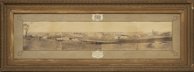
Photograph - Framed photograph of Warrnambool 1887, Town Panorama. Warrnambool Queen's Jubilee 1887, 1887
This is a framed photograph of a panoramic section of the Warrnambool township taken in 1887 to commemorate the Jubilee of the reign of Queen Victoria (1837-1887). The photograph is taken from Booval Hill (Liebig Street north) and shows the fencing in that area with groups of people in the foreground posing for the photograph. The panorama covers Liebig Street and Raglan Parade and includes private houses, a windmill and three tanks, St. John's Church, St. Joseph's Church, Tattersalls Hotel and the Saleyards.This photograph provides us with historical information on a section of the Warrnambool township in 1887 and is a valuable resource for researchers.This is a black and white photograph in a brown wooden frame and enclosed in glass. The photograph has a gilt metal edging outlined with ornate kite-shaped pieces on the corners and depicts a section of a town from an elevated position. At the top of the photograph is a crest in a shield shape and at the bottom is another shield shape containing the title of the photograph. The left centre section of the photograph is splotched or water-stained.Warrnambool Queen's Jubilee 1887warrnambool 1887, queen victoria's jubilee -
 Ballarat Tramway Museum
Photograph - Digital image Set of 4, Paul Mong, 21/09/2019 12:00:00 AM
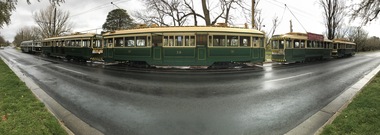
Set of four digital images of the 2019 Tramcar Showcase by Paul Mong on 21/9/2019. .1 - a view of the trams lined up at St Aidans Drive prior to the Cavalcade using a mobile phone panorama feature with tram 38 in the centre. .2 - as above but with tram 13 in the centre. .3 - Group photo of the traffic staff and helpers on the day. .4 - Line of up of trams prior to the Cavalcade.trams, tramways, btm, tramcar showcase, events, cavalcade, wendouree parade, tram 13, tram 38, tram 26 -
 Ballarat Tramway Museum
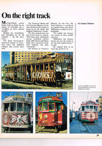
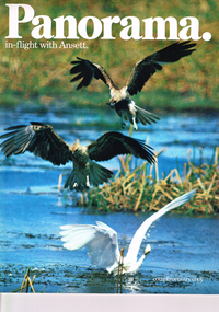
Magazine, Ansett Airlines, "Panorama in-flight with Ansett", "On the right track", Apr. 1982
Pages 29 and 30 of the March / April 1982 issue of "Panorama in-flight with Ansett", No. 4 with an item titled "On the right track" featuring eight Transport Art trams with photos and text. Written by Stephen Gilfedder. Trams: 567 (Peter Corrigan - slightly modified from the original - see Electric Traction August 1979 for notes on modification of paintwork.), 243, 607, 525, 504, 384, 336 and 497.trams, tramways, transporting art, decorated trams -
 Lorne Historical Society
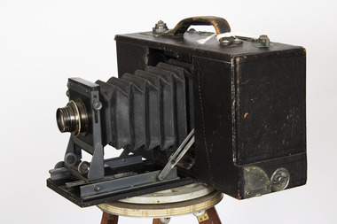
Tool - Cirkut Panoramic Camera Number 5, Circa 1915
This camera was designed by William Johnston in 1904. Production began in 1905. There were many versions, the number indicated the length of film which corresponds to the width of the panorama. Originally designed for photography of large groups of people. Later it was used for landscapes. This camera was used by the local Lorne photographer William Anderson who took photographs of visitors and local scenes. William purchased Norman Brown’s photographic business in December 1899 and worked in Lorne until his death in 1948It is a large format rotating panoramic camera. A concertinaed fine leather tube with the adjustable lens is contained in a black wooden leatherette covered rectangular box. On the top is a metal winding handle, a series of weights and a carrying handle. The lens is a Gundlach - Manhattan rapid recto graph. The camera rotates on a geared tripod through 360 degrees with the film driven past the exposure slot by a clock work motor.cameras, lorne, william anderson, -
 Glenelg Shire Council Cultural Collection
Photograph - Photographs - Hand Coloured, various Portland landmarks, c. 1940
Identification numbers 9200 a-g Folder containing Valentine's Snapshots - 8 hand-coloured photographs of Portland 9200 - folder grey green card, black print 9200 a-g a) Path in gardens, Portland b) Looking towards lighthouse, Portland c) View along beach, Portland d) Post office and Mac's Hotel e) The famous Portland Lifeboat of 1859 f) Edward Henty memorial g) Panorama of Portland -
Glenelg Shire Council Cultural Collection
Photograph - Photograph - Portland Harbour, n.d
Panoramic black and white photo o Portland Bay, showing ocean Pier, Public baths, Harbour, Battery Point and Bentinck street. Gold frame and gold mount.Front: Bottom left of photo: Panorama of Portland Victoria (Length of ocean Pier 2880 ft) - white Bottom right of photo: The Valentine Publishing 10 PTY, LTD Melbourne - white Sticker: L. Frith Picture From Manufacturer 17 Paisley Street Street, Footscray -
 Warrnambool and District Historical Society Inc.
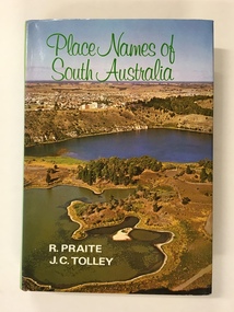
Book, Place Names of South Australia, 1970
This book gives information on the place names of South Australia and the origins of the names. It was compiled by Ronald Praite and John Tolley in 1970 and so is somewhat out of date as more place names would have to be added today. European settlement began in South Australia in 1836.This book is of minor interest to those in the Warrnambool area and may be useful for those researchers whose families have some connection to early South Australian history. This is a hard cover book of 208 pages. The cover is dark red with the names of the book and the authors on the spine. The dust cover has a colour photograph of a South Australian panorama on the front and a plain green back cover. The book has a Foreword, Sources of Reference, Acknowledgements, Introduction and an alphabetical listing of South Australian place names and the origins of the names. There are many black and white photographs supplied by the South Australian Tourist Bureau. There is some colour fading on the dust cover.Front Cover: ‘Place Names of South Australia’ ‘R.Praite’ ‘J.C.Tolley’ history of south australia, place names of south australia, ronald praite, john tolley -
 Bendigo Historical Society Inc.
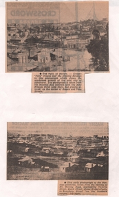
Newspaper - NEWSPAPER CLIPPINGS EARLY PHOTOGRAPHS OF BENDIGO STREETSCAPE, Unknown
Two Black & White Early Photographs of Bendigo. (Photograph 1) Panorama is taken from the Masonic Hall location with the Rifle Brigade Hotel on the corner of Rowan and View Streets and Knipe's Folly in top right of image. (Photograph 2) An early photograph of the Bendigo Goldfields the suburb of Ironbark taken from the vicinity of Mt. Korong Road, overlooking Victoria Street and Quick Street. Image shows Knipe's Castle in Boundary Street ''on the Ironbark Ranges'' top right.bendigo, streetscape, rowan & view st, mt korong rd -
 Bendigo Historical Society Inc.
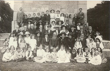
Photograph - PETHARD COLLECTION: FAMILY PORTRAIT, 5.9.1915
Photograph - Postcard - Black & white - family portrait.Written on back of postcard. ' Liverpool 5.9.15. Leaving today for Australia via Canada with evergreen memories of our visit to England and the Continent - a panorama of delightful scenes and varied experiences - crowned with glorious weather and many good wishes. G.A.P. It is addressed to Miss L.Pethard, Golden Square. Also a penny stamp.-In the 2nd row from bottom, you can see George (snr) Pethard and wife Mirim to his left.person, family, pethard family, photograph. pethard family. 5.9.1915 in liverpool. -
 Melbourne Tram Museum
Magazine, Ansett Airlines, "Panorama in-flight with Ansett", "On the right track", Apr. 1982
Full colour, 52 pages, printed on gloss paper magazine - "Panorama in-flight with Ansett", No. 4, March / April 1982 featuring on pages 29 and 30 an item "On the right track" featuring eight Transport Art trams with photos and text. Written by Stephen Gilfedder. Trams: 567 (Peter Corrigan - slightly modified from the original - see Electric Traction August 1979 for notes on modification of paintwork.), 243, 607, 525, 504, 384, 336 and 497.trams, tramways, transporting art, decorated trams, tram 243, tram 607, tram 525, tram 504, tram 384, tram 336, tram 497 -
 Eltham District Historical Society Inc
Document - Series Listing, Fraser Faithfull et al, Series 21: Eltham Library construction, 300 photographs, sketch plans, 2000
Series consists of I) 7 sepia toned photographs or Librarian Linda McConnell inspecting work on the site orthe new library. 2) 11 B& W, sepia and colour photographs or work on the site. 3) 3 laminated colour sketches: floor plan, roor plan & exterior 4) A set or approximately 280 colour snapshots documenting work on the construction site, arranged chronologically month-by-month. There are also 5 "panorama" panels or between 2-4 snapshots taped together. These have been mounted on acid-free card.shire of eltham archives, series listing -
Kew Historical Society Inc
Plan - Camberwell Panorama Estate, 1923
Subdivision plans and real estate flyers/brochures reveal a number of aspects of urban development and history. The Kew Historical Society's collection of these plans, as well as advertisements extracted from magazines, cover key aspects of community development and architectural history of Kew and Kew Eat as well as surrounding suburbs. While most of the plans in the collection were gifted to the Society by the former City of Kew, a number of other plans and advertisements have been donated by individuals, of which this is an example.Promotional brochure for the Camberwell Panorama Estate. The four page bifold handout advertises 216 home sites bounded by Bulleen Road, The Nook, Fortuna Avenue, and Doncaster Road. Other streets in the subdivision include: Sunburst Avenue, The Moor, and Macedon Avenue. The brochure has been damaged at some time in the past and so masking tape obscures the tram on page 1. Page 2 includes the plan of the subdivision, page 3 information about the site and a locality plan, while page 4 includes photographs and terms of sale. subdivision plans -- balwyn north (vic.), camberwell panorama estate -
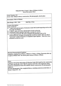
 Bendigo Military Museum
Photograph - ANZAC DAY PHOTOS BRSL, C. 1950 - 51
The photo in .2) cylinder is an original of the top photo in .1) in front of the Soldiers Memorial Institute. Even though it says 1951 this is not a certainty for both. It has not been taken out for proper photography due to its fragile state. There are a few that have been identified in both who were well known. Top photo. Standing 2nd from the left is Jack Swatton, next to him is George Lansell, further along standing at rear is a tall man Les Morey with black hair and greyish suit. Bottom photo. On the far right standing is Jack Swatton, in the front row sitting central is possibly George Lansell, two men to his right are looking at him, in the rear 8th from the left is Les Morey. There is one very tall man in the rear central which his identity is being checked. Refer also Cat No 8229P. .1) Photographs B & W panorama, two laminated together. The top photo shows a large group of men and some ladies lined up in front of the Soldiers memorial Institute Pall Mall Bendigo, there are 5 large wreaths and a big white Cross central. The bottom photo shows a larger group of men and 3 young lads on the "Upper Reserve" in Bendigo. .2) Shows a cardboard photo cylinder with address paper around with text showing a section the rolled photo out at one end of the cylinder.On .1) written over in black is hand written, "1951 ANZAC DAY", on .2) hand written, "G.B. ... 541 High S.....et Bendigo"brsl, smirsl, anzac day -
 Eltham District Historical Society Inc
Photograph - Aerial Photograph, Landata, Lower Plenty, Vic, Apr. 1963
Centred on present day Old Eltham Road near Araluen Centre, Lower Plenty bounded by Cromwell Street to north, Yarra River to south, Main Road at Mount Pleasant Road to east and Panorama Avenue to west. Historic Aerial Imagery Source: Landata.vic.gov.au Aerial Photo Details: Project No :486 Project : MELBOURNE (1963) PROJECT Run : 7 Frame : 231 Date : 04/1963 Film Type : B/W Camera : RC8 Flying Height : 5100 Scale : 9600 Film Number : 1805 GDA2020 : 37°44'03"S, 145°07'56"E MGA2020 : 335420, 5822027 (55) Melways : 21 F10 (ed. 42)aerial photo, neil webster collection, 1963-04, araluen, cromwell street, eltham, lower plenty, main road, melway 21f10, mount pleasant road, old eltham road, panorama avenue, yarra river -
 Melbourne Tram Museum
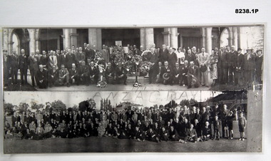
Ephemera - Real estate sale, Cranny Sambell & Co, "Camberwell Panorama Estate", Oct. 1923
Pamphlet advertising the sale of land at the "Camberwell Panorama Estate" - Doncaster and Bulleen Road 13-10-1923. Gives terms of sale, photos showing the views and a nearby shopping centre. Has a large photo of MMTB No. 20 on the front cover. The tramcar is of the Hawthorn Tramways Trust four-door bogie type. MMTB No 20 was an ex-Prahran and Malvern single trucker or small tram A class. Gives details of the 110 lots to be sold, terms, location, and that the tram was proposed to be extended to the corner. This extension took place in 1937. The locality plan shows proposed plans for tram lines in Belmore Road and Burke Road north of Whitehorse Road. Demonstrates the style of land sale pamphlet including the availability of tram services to prospective purchasers.Pamphlet - folded - printed in two colours of cream coloured paper with photographs and plans.has pencil notes on the top of the front page.sale of land, trams, real estate, camberwell panorama estate, east camberwell, doncaster road, bulleen road, tram 20 -
 Bendigo Historical Society Inc.
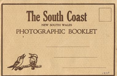
Document - J W SWATTON COLLECTION: PHOTOGRAPHIC BOOKLET
The South Coast New South Wales Photographic Booklet has a light brown rippled cover with dark brown printing and frame with two kookaburras in the bottom left corner. 1940 written in the bottom right corner. On the back it has From and Published by the Valentine Publishing Co. Pty. Ltd., Sydney and Melbourne. The inside has a panorama view from Sublime Point and smaller views of the South Coast, Mt Kiera Raod, Wollongong, Bulli Pass, the Harbour Wollongong, Austinmer, The Blowhole Kiama, near Sublime Point, The Bridge Shoalhaven river Nowra,person, receipts, j w swatton, j w swatton collection, the south coast nsw, the valentine publishing co pty td, sublime point, stanwell park, wollongong, bulli pass, thirroul, austinmer, the blowhole kiama, nowra -
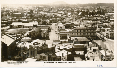 Ballarat Tramway Museum
Photograph - Digital image, Rose Stereograph Co, c1929
Yields information the buildings, and the general scene from the Post Office looking over Ballarat East towards Mount Warrenheip.Digital image from the Wal Jack Ballarat Album of a postcard - titled "Panorama of Ballarat East Vic. The Rose Series Postcard No. P 3164. Two ESCo trams are in the west end of Bridge St at Grenville St. Photo looks east from the Post Office tower, has the Alfred Hall, the Drill Hal and many other major buildings in the view. Wal has dated the photo in ink in the bottom right hand corner 1928, and about 1930 on the rear and 1929 in his album notes. For rear of postcard - see image i2.trams, tramways, esco, ballarat east, alfred hall -
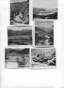 Kiewa Valley Historical Society
Photos - Kiewa Hydro Electric Scheme - Kiewa Valley x2
The SECV constructed the Kiewa Hydro Electric SchemePhotos showing the development and history of the Kiewa Hydro Electric Scheme2 copies of 8 small b & w photos. All with titles including "Kiewa Hydro Electric Project". They are in an envelope titled "Valentine's / Snapshots / Eight Real Photographs / Kiewa Valley / Published by /The Valentine Publishing Co. Pty. Ltd / Melbourne and Sydney 1. Kiewa Valley Panorama 2.The East Kiewa River 3. Road to Bogong High Plains 4. Mt Beauty Village 5. Snowfall Bogong Village 6. Bogong Village 7. Junction Dam Spillway, Lake Guy Bogong 8. No 3 Power Station mt beauty, bogong village, bogong high plains, junction dam, power station -
 Alfred Hospital Nurses League - Nursing Archive
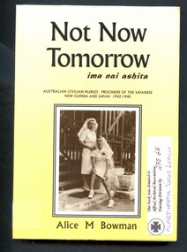
Book - Illustrated Book, Alice M. (Alice Mary) Bowman 1912-2000, Not now tomorrow=ima nai ashita, 1996
A true story of a civilian nurse from the Government Hospital in Rabaul, who was held prisoner in New Britain (six months) and Japan (3 years) following the Japanese attack of Rabaul in 1942Illustrated book with dust jacket. Book has a yellow cover with title and author's name printed in white on front and spine. Dust jacket has a pale-yellow background, title and author's name printed in brown on front and spine. The front of the dustjacket also has a black and white photograph of the author (Alice Bowman) (seated) and Joyce McGahan (standing) they are wearing Sisters uniforms; a building of the Namanalu Hospital, Rabaul is behind them (1939). On the back cover is another black and white photograph: Rabaul panorama, and a summary of the book in brown print. non-fictionA true story of a civilian nurse from the Government Hospital in Rabaul, who was held prisoner in New Britain (six months) and Japan (3 years) following the Japanese attack of Rabaul in 1942world war 1939-1945, prisoners of war-papua new guinea, prisoners of war-japan, nurses -
 Lara RSL Sub Branch
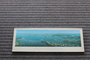
Framed Print of Naval Review,Sydney Harbour, 1st October,1988, Naval Review,Sydney Harbour, 1st October,1988, 12/01/1990
The bicentenary of Australia was celebrated in 1988. It marked 200 years since the arrival of the First Fleet of British convict ships at Sydney in 1788. This aerial photo shows naval and pleasure craft in Sydney Harbour for the bicentennial celebrations.The bicentennial year marked Captain Arthur Phillip's arrival with the 11 ships of the First Fleet in Sydney Harbour in 1788, and the founding of the city of Sydney and the colony of New South Wales. 1988 is considered the official bicentenary year of the founding of Australia. Rectangular shaped glass covered picture frame showing photo of Naval Review, Sydney Harbour, 1st October,1988Naval Review, Sydney Harbour, 1st October,1988 This 140 degree panoramic photograph was taken from a helicopter by Phil Gray. It shows the visiting warships in the harbour including the USS New Jersey, FNS Colbert and HMS Ark Royal in the foreground.This print is the fourth in the Sydney Harbour Panorama series by Phil Gray who uses Kodak film.Printed in Australia.prints, naval photos, hms ships, sydney harbour, lara r.s.l. -
 Eltham District Historical Society Inc
Slide, Main Road, Lower Plenty, 25 Jul 1973
This section of Main Road was known by locals as the "Windy Mile" due to its many little wists and turns. It was also the setting for Billy Cart derbies held on special occassions such as the Eltham Easter Gymkhana at Eltham Lower Park. Contestants would line up and race each other down the hill to the finish line at Bolton Street. Main Road, Lower Plenty underwent substantial changes when it was duplicated with the road becoming two lanes each way and split level due to the cross gradient. This particular section running down the hill from Panorama Avenue to Bolton Street with its twists and turns had many of them straightened out during the road widening constuction work.35 mm colour positive transparency Mount - Agfacolor Service (Blue)main road, infrastructure, lower plenty, roads, windy mile -
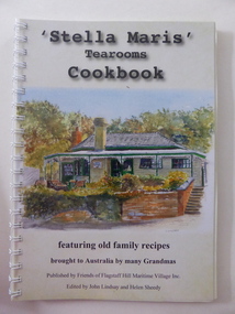 Warrnambool and District Historical Society Inc.
Book, Stella Maris tearooms FSH, 2016
This cook book has been published by the Friends of Flagstaff Hill Maritime Village Inc. This group do volunteer work at Flagstaff Hill, publicize the activities and historical collection at the Village and raise funds to carry out improvements and new installations. Flagstaff Hill Maritime Village was established in 1975, initially as a private venture sponsored by a group of businessmen in Warrnambool but it was later taken over by the Warrnambool City Council. It operates as an historical park and a tourist venture every day of the year except Christmas Day and has a night Sound and Light Show called ‘Shipwrecked’. The historical collection at the Village features many important shipwreck relics from the area, with the most important being the ‘Loch Ard’ ceramic peacock. The cook book is a tribute to the local women of the past and there are many recipes collected from the ‘Grannies’ of yesteryear. The tea rooms at Flagstaff Hill Maritime Village are called ‘Stella Maris’ (Latin for ‘Star of the Sea’) and call to mind both the maritime heritage of the area and the name of the Australian Catholic Missions to Seamen which still operates. This book is of interest as a product of Flagstaff Hill Maritime Village. It has been edited by John Lindsay who was one of the founders of Flagstaff Hill in 1975 and is today a Life Member and Helen Sheedy who has also been connected with the administration of the Village in the past. The book also features art works from many artists from Warrnambool and district. This is a soft cover book of 100 pages. The cover has a white background with a colour sketch of the Flagstaff Hill Maritime Village Stella Maris Tea Rooms on the front cover and a colour photograph of a Flagstaff Hill panorama on the back cover. The book contains an introduction, some information related to food, cooking and diet, recipes from the past and present, some local historical material and some information on the artists whose work is featured in the book. Many colour sketches and photographs are scattered throughout the text. The book is bound with plastic spiral rings and the front is covered with a sheet of clear plastic. stella maris tea rooms, warrnambool, flagstaff hill maritime village, history of warrnambool -
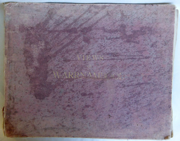 Warrnambool and District Historical Society Inc.
Album - Views of Warrnambool by J Jordan, C 1901
Joseph Jordan was born in 1841 in Leicester England and spent over a decade in India with his regiment. In 1867 he gained first prize for his views of Indian scenery. He followed the same profession when he came to Victoria in 1884 and set up a professional photographic studio in Warrnambool He became very well known in the Western District for family photographs as well as official photographs of local councillors and groups as well as views of local scenery. This album is one which was advertised in 1901. Of the two albums in the collection they seem to consist of a core number of the same photographs with others included in the selection. The business was taken over by his son Arthur around 1917. This album includes a number of professionally taken photographs which give a high quality view of Warrnambool and the popular spots around the district at the turn of the century.Faded Maroon cloth over card cover with title in gold lettering on front cover. Advertisements for local businesses inside front and back covers. The album contains a number of black and white photographs from around Warrnambool, including the Titan crane at the Breakwater, banks of the Hopkins, Stephens Coachbuilders, Grand Annual Show, panorama of Warrnambool and Suspension Bridge on the Merri. All are mounted on card. It includes advertisements of J J O Mullane, Bay View Hotel, Hopkins Hotel, T Redford, Royal Hotel, Robinson and Morse, H D Stewart & Co, F Uren.2142 in grey lead inside front cover.warrnambool, joseph jordan, views of warrnambool, photograph album of warrnambool, views of warrnambool 1891 -
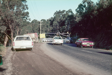
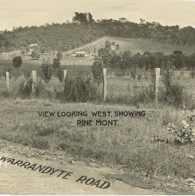 Ringwood and District Historical Society
Document - Property Titles, Transfer of Land Act - "Pinemont", Ringwood, Victoria
Folder containing copies of LANDATA documents relating to "Pinemont", Panorama Avenue, Ringwood, Victoria, compiled for potential real estate sales background information purposes. Title Vol 965 Fol 923 Allotment 27B Parish of Warrandyte - James Forbes, dated 30th August, 1876. Title Vol 5236 Fol 1947157 Lots 294 and 370 on Plan of Subdivision no.11392 - Anthony Loughnan, dated 4th March, 1927. Title Vol 6415 Fol 1282937 Lot 294 on Plan of Subdivision no.11392 - Jessie McCracken Rothwell Woodard, dated 9th September, 1940. -
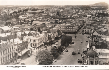 Ballarat Tramway Museum
Postcard, Rose Stereograph Co, "Panorama showing Sturt Street, Ballarat Vic.", 1940s
The photo is a Panorama showing Sturt Street, taken from the Town Hall, looking north east with Mount Warrenheip and Black Hill in the view. Shows the buildings east of Lydiard St, including Bridge St, Camp St and part of Victoria St. One tram is westbound, about to cross Lydiard St. Rose Series P4500. Has signs for the "Mail Echo", Plume petrol, ANA, the Mechanics Institute, and Longhurs Bread. On the rear Wal Jack has written extensive notes for Ken Magor noting the streets in the view and the Ballarat East loco depot and Goods shed. Wal has dated the photo 1940 to 1944, though the trams do not have white bumper bars that featured from 1941 to 1945.Yields information about Ballarat during the 1940sPostcard black and white, divided back, with a handwritten note on rear.See image 2 for details of the handwritten note by Wal Jack on the rear. tramways, trams, bridge st, sturt st, ballarat east, rose postcards -
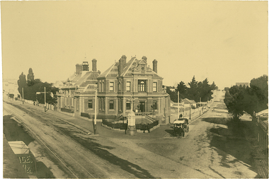 Kew Historical Society Inc
Photograph, J F C Farquhar, The Post Office, 1891
At the beginning of the 1890s, the Kew businessman and Town Councillor, Henry Kellett, commissioned J.F.C. Farquhar to photograph scenes of Kew. These scenes included panoramas as well as pastoral scenes. The resulting set of twelve photographs was assembled in an album, Kew Where We Live, from which customers could select images for purchase.The preamble to the album describes that the photographs used the ‘argentic bromide’ process, now more commonly known as the gelatine silver process. This form of dry plate photography allowed for the negatives to be kept for weeks before processing, hence its value in landscape photography. The resulting images were considered to be finely grained and everlasting. Evidence of the success of Henry Kellett’s venture can be seen today, in that some of the photographs are held in national collections.It is believed that the Kew Historical Society’s copy of the Kellett album is unique and that the photographs in the book were the first copies taken from the original plates. It is the first and most important series of images produced about Kew. The individual images have proved essential in identifying buildings and places of heritage value in the district.A panoramic photograph of the junction of High Street and Cotham Road. The photographer centres the point-of-view on the Kew Post Office and adjacent Court House. These were designed in the Queen Anne style by the Public Works Department's architect J Harvey and completed in 1888. The complex is important because it demonstrates a departure from the contemporaneously favoured High Victorian Classical to the Queen Anne style in the design of civic buildings. The earlier Jubilee Fountain in front of the Post Office was erected by the Kew Borough Council to commemorate the Golden Jubilee of Queen Victoria in 1887. It was created to a design of the architects Reed, Henderson and Smart. The fountain was later relocated to the Alexandra Gardens to make way for the Kew War Memorial. The tram tracks in High Street were used by the horse tram, which ran from the Victoria Street Bridge to the Boroondara General Cemetery. The tram was replaced by an electrified service in 1915.The Post Officekew post office, kew illustrated, kew where we live, photographic books, henry kellett -
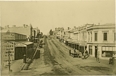 Kew Historical Society Inc
Photograph, J F C Farquhar, High Street, Kew, 1891
At the beginning of the 1890s, the Kew businessman and Town Councillor, Henry Kellett, commissioned J.F.C. Farquhar to photograph scenes of Kew. These scenes included panoramas as well as pastoral scenes. The resulting set of twelve photographs was assembled in an album, Kew Where We Live, from which customers could select images for purchase.The preamble to the album describes that the photographs used the ‘argentic bromide’ process, now more commonly known as the gelatine silver process. This form of dry plate photography allowed for the negatives to be kept for weeks before processing, hence its value in landscape photography. The resulting images were considered to be finely grained and everlasting. Evidence of the success of Henry Kellett’s venture can be seen today, in that some of the photographs are held in national collections.It is believed that the Kew Historical Society’s copy of the Kellett album is unique and that the photographs in the book were the first copies taken from the original plates. It is the first and most important series of images produced about Kew. The individual images have proved essential in identifying buildings and places of heritage value in the district.In 1891, High Street was the centre of commercial activity in the Borough of Kew. It was unpaved and edged with deep bluestone gutters, which were designed to channel the significant flow of storm water down the hill to and beyond the Junction. On either side of the entrance to the shopping strip are two cast iron gas lamps that provided the only public street lighting before the Post Office was reached. Most shops, including the Nicholas Brothers’ Junction Store featured cast iron verandas. Further up the hill, Dougherty’s Greyhound Hotel was by this stage a local institution. Apart from the horse-drawn tram, the main form of personal and commercial transport in this period remained the horse, horse and cart, or buggy.The panoramic view predates the widening of High Street in the 20th century, and thus includes the original alignment of buildings on the south side. These included Henry Kellett’s shop.High Street, Kewkew illustrated, kew where we live, photographic books, henry kellett, high street - kew (vic) -
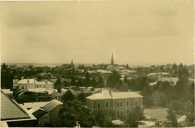
 Kew Historical Society Inc
Photograph, J F C Farquhar, Bird's Eye View Looking West, 1891
At the beginning of the 1890s, the Kew businessman and Town Councillor, Henry Kellett, commissioned J.F.C. Farquhar to photograph scenes of Kew. These scenes included panoramas as well as pastoral scenes. The resulting set of twelve photographs was assembled in an album, Kew Where We Live, from which customers could select images for purchase.The preamble to the album describes that the photographs used the ‘argentic bromide’ process, now more commonly known as the gelatine silver process. This form of dry plate photography allowed for the negatives to be kept for weeks before processing, hence its value in landscape photography. The resulting images were considered to be finely grained and everlasting. Evidence of the success of Henry Kellett’s venture can be seen today, in that some of the photographs are held in national collections.It is believed that the Kew Historical Society’s copy of the Kellett album is unique and that the photographs in the book were the first copies taken from the original plates. It is the first and most important series of images produced about Kew. The individual images have proved essential in identifying buildings and places of heritage value in the district.Before true aerial photography became possible, photographers such as J.F.C. Farquhar were compelled to shoot their images from the highest vantage point. Here, it is presumed to be the roof of Xavier College, from which the panoramic view extends west towards the rise of Studley Park. The houses in the foreground face the southern end of Gellibrand Street. Wellington Street is at an angle to the camera with the Queen Street intersection on the near right. The wooden building behind the large horse paddock on the other side of Gellibrand Street is the Kew Recreation Hall, built 1888, demolished 1960. It was reputed to have one of the finest dancing floors in or around Melbourne. The Bowling Green at the rear of the Hall belonged to the Kew Bowling Club. Further west is the Kew Railway Station on Denmark Street, opened to the public in 1887. At this period, much of Studley Park was locked up in large landholdings, dominated by large mansions such as ‘Byram’. Bird's Eye View Looking Westkew illustrated, kew where we live, photographic books, henry kellett, denmark street, kew recreation hall, kew bowling club, wellington street -
 Kew Historical Society Inc
Photograph, J F C Farquhar, Bird's Eye View Looking North, 1891
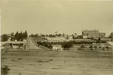
At the beginning of the 1890s, the Kew businessman and Town Councillor, Henry Kellett, commissioned J.F.C. Farquhar to photograph scenes of Kew. These scenes included panoramas as well as pastoral scenes. The resulting set of twelve photographs was assembled in an album, Kew Where We Live, from which customers could select images for purchase.The preamble to the album describes that the photographs used the ‘argentic bromide’ process, now more commonly known as the gelatine silver process. This form of dry plate photography allowed for the negatives to be kept for weeks before processing, hence its value in landscape photography. The resulting images were considered to be finely grained and everlasting. Evidence of the success of Henry Kellett’s venture can be seen today, in that some of the photographs are held in national collections.It is believed that the Kew Historical Society’s copy of the Kellett album is unique and that the photographs in the book were the first copies taken from the original plates. It is the first and most important series of images produced about Kew. The individual images have proved essential in identifying buildings and places of heritage value in the district.This panoramic view was probably taken from the roof of Xavier College. It invites the viewer to look down on the buildings and streets of Kew, and across to the distant horizon. Mansions and solid bourgeois villas dominate the view of Charles and Wellington Streets. The imposing spires of the Presbyterian and Methodist Churches, built in one of the highest areas of Kew, can be seen in the distance. In the foreground, the photographer includes three significant mansions: Molina, Roxeth and Elsinore. Molina, in the foreground, and the group of weatherboard buildings in its yard was used at this stage for the privately operated ‘Kew High School’ (founded 1872). Roxeth, the home of Herbert Henty can be identified by its distinctive four-sided tower. All three buildings are now part of Trinity Grammar. Other built structures observable in the photograph include Wilton (now the Kew RSL), designed by Guyon Purchas for Dr William Walsh in 1886, and the only known image of the Prospect Hill Hotel prior to the renovation of 1935. Bird's Eye View Looking Northkew illustrated, kew where we live, photographic books, henry kellett -
 Kew Historical Society Inc
Photograph, J F C Farquhar, Wellington Street From High Street, 1891
At the beginning of the 1890s, the Kew businessman and Town Councillor, Henry Kellett, commissioned J.F.C. Farquhar to photograph scenes of Kew. These scenes included panoramas as well as pastoral scenes. The resulting set of twelve photographs was assembled in an album, Kew Where We Live, from which customers could select images for purchase.The preamble to the album describes that the photographs used the ‘argentic bromide’ process, now more commonly known as the gelatine silver process. This form of dry plate photography allowed for the negatives to be kept for weeks before processing, hence its value in landscape photography. The resulting images were considered to be finely grained and everlasting. Evidence of the success of Henry Kellett’s venture can be seen today, in that some of the photographs are held in national collections.It is believed that the Kew Historical Society’s copy of the Kellett album is unique and that the photographs in the book were the first copies taken from the original plates. It is the first and most important series of images produced about Kew. The individual images have proved essential in identifying buildings and places of heritage value in the district.Very few of the natural or built features in this panoramic photograph of Wellington Street remain. The open land between High Street South and Denmark Street, then known as O’Shannessy’s Paddock, was to become a residential subdivision at the beginning of the 20th Century. On the far side of Denmark Street, bordered by a picket fence, is the Kew Railway Station (demolished 1957). Further east, the large building with the flagpole is the Kew Recreation Hall (demolished 1960), which was the centre of civic life for almost a century. The building was used for dances, civic functions and exhibitions. A bowling green, tennis courts, and a cricket ground surrounded the Hall. The dominant building in the photograph is Xavier College, founded in 1872 by the Society of Jesus. The first classes for pupils were held in 1878. It is presumed that Farquhar used its roof for two of his bird’s eye views.Wellington Street from High Streetkew illustrated, kew where we live, photographic books, henry kellett