Showing 348 items
matching panoramic
-
 Lakes Entrance Regional Historical Society (operating as Lakes Entrance History Centre & Museum)
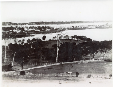
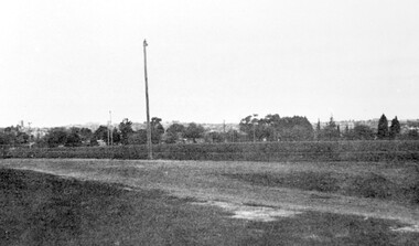
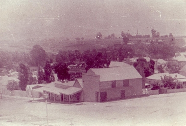
Photograph - Lakes Entrance, 1935c
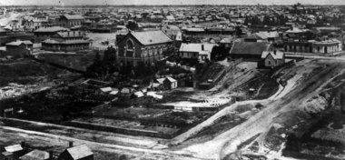
Enlarged from postcard produced for Mrs Allen to advertise Allen's Tearoom at the brow of Myer St hill, known as Allen's Hill to locals.|This is the paired before photograph showing the left hand side on Butchers paddock in the panoramic views, the right hand side number 01715. This photograph used in the 150 year Lakes Entrance 1858-2008 display.Black and white photograph of the township, taken from Allen's Hill, Myer St. It shows the town between Cunninghame Arm and North Arm, cleared and fenced paddocks in foreground, New Works village and sand hummocks in distance. Lakes Entrance Victoria township, waterways, topography -
 Federation University Historical Collection
Photograph (black & white), M.B. John Brass Foundry Workers, 1927
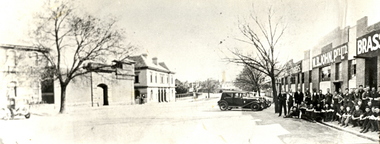
In 1896 M.B. John started the Ballarat Brass Foundry in Armstrong Street South on land leased from the Welsh Church. See http://bih.ballarat.edu.au/index.php/Ballarat_Brass_Foundry#BackgroundTwo black and white photographs of MB John Brass Foundry Workers at their Armstrong Street factory. When joined together one large panoramic view is made, which also includes the gates of the Ballarat Gaol. Three men standing to the far right are members of the John family. john valves, mb john, tom bawden, ballarat gaol, m.b. john, morgan b. john, morgan bevan john, valves, engineering, lydiard street south, ballarat -
 Lakes Entrance Regional Historical Society (operating as Lakes Entrance History Centre & Museum)
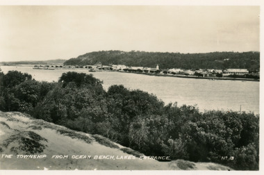
Postcard - Township, 1935c
Black and white small format postcard of town, taken from south shore of the lake. It shows a panoramic view of Esplanade and buildings, jetties, Great War Memorial cypress trees, Jemmys Point and Kalimna Heights in background. Vegetation of sand hummocks in foreground. Lakes Entrance VictoriaThe Township from Ocean Beach Lakes Entrance No 13memorials, vegetation, waterfront, township -
 Port Melbourne Historical & Preservation Society
Photograph - Port Melbourne, Pat Grainger, 1996
Four panoramic black&white photos taken c1996 .01 View toward city of Nott Street and the school .02 View toward city of Nott Street, vertical .03 Pedestrian crossing in front of the 1910 post office .04 View north of Bay Street footpath, west sidebuilt environment, nott street, bay street -
 South Gippsland Shire Council
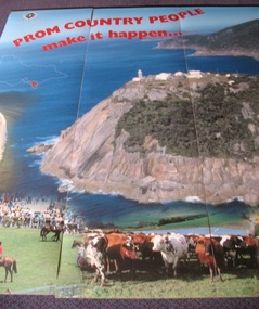
Panel, Panorama, Prom Country People Make it Happen
5 large vinyl panels featuring a colour panoramic photograph of Wilsons Promotory. Red text and images of people and food overlaid on surface. Text reads: "PROM COUNTRY PEOPLE MAKE IT HAPPEN" Includes fold out aluminium hanging frame, brackets and red plastic storage cannister on wheels. -
 Surrey Hills Historical Society Collection
Photograph, Corner of Braemar and Melrose Streets, Box Hill North
Reproduced by permission of Mr John Arnold from his book: "The Riversdale Golf Club - a history, 1892-1977." Copyright to book: Riversdale Golf Club. Surrey Hills Golf Club operated from 1892-1908 then moved and became Riversdale Golf Club. The game was played across paddocks from Trafalgar Street, Mont Albert to Whitehorse Road and down Victoria Crescent to where Box Hill TAFE is now located in Elgar Road. There were problems with cows eating the tee flags! The clubhouse still exists as 30 Trafalgar Street.Black and white panoramic photo taken from the corner of Braemar and Melrose Streets, Box Hill North. There is a large area of ground in the front. A fence and hedge traverse the photo in the middle distance in front of which is a tall light pole. Behind the hedge mature trees and houses can be made out.Caption: "Bottom: The same view today taken from the corner of Braemar and Melrose Streets, Box Hill North, or, from the position of the threesome to the left in the above photograph." + in grey lead pencil in Jocelyn Hall's hand (No 290)sports grounds, surrey hills golf club, riversdale golf club, melrose street, braemar street, surrey hills, john arnold -
 Eltham District Historical Society Inc
Photograph, Peter Bassett-Smith, Former Brinkkotter Poultry Farm, Main Road, Research, April 1988, 1988
Four colour photographs of the former Brinkkotter Poultry Farm, Main Road, Research depicting the 'Regency Acres' real estate development of 22 lots advertised for auction 19 April 1988. The four photographs are shot by Peter Bassett-Smith in a panoramic sweep of the estate from Eltham College to the Research Primary School.poultry farm, main road, research vic., brinkkotter -
Port Melbourne Historical & Preservation Society
Photograph - Former Port Theatre centre window restored, Bay Street, Port Melbourne, David Thompson, Oct 1996
Record shots were taken over a three year period; stage in renovations by owner Despinis Kapogiannis and tenant Ian WilsonB&W photo of former Port Theatre October 1996: Original centre window restored. From set of five panoramic photos showing stages of development, former Port Theatre - restored in 1996 as shops and offices. This picture is 1993 from Liardet st across Bay st and the building is still unrenderedbuilt environment - commercial -
 Bendigo Military Museum
Poster - POSTER, FRAMED, "The Family Herald and The Weekly Star", Montreal Canada, " CANADA RALLY TO THE EMPIRE - ANSWERING THE CALL OF THE MOTHERLAND", 1914
From relevant information - "The poster was sent to my Grandmother's father (John Garriock) from Canada. It was a giveaway in a Canadian farming magazine of the time. My Grandmother (Barbara Ross) and Grandfather (Robert Heddle Ross) kept the poster and it eventually came to me. I wish to donate it as a way of remembering them".Poster - panoramic poster, paper, black and white, depicts the "Canadian Army setting sail to join British Forces operating against Germany in the War of Nations". Collection of ships setting sail. Print below illustration. Frame - timber, brown/black stain/paint, cardboard backing to poster, cardboard backing. Glass front.framed item, poster, canada, 1914 -
 Clunes Museum
Photograph
ORIGINAL PHOTOGRAPH ON LOAN FOR COPYING FROM MRS. MARSHALLSEA..1 BLACK AND WHITE PHOTOGRAPH PANORAMIC VIEW FROM BAILEY STREET CLUNES LOOKING NORTH TOWARDS CLUNES HIGHER ELEMENTARY SCHOOL NO 1552, CANTERBURY STREET. TURNBULL'S PRODUCE STORE IN FOREGROUND CORNER BAILEY AND TEMPLETON STREET. .2 .3 BLACK AND WHITE COPIES OF THE ABOVE PHOTOGRAPH PRINTED ON GLOSS PHOTOGRAPHIC PAPERphotography, shops turnbulls produce store, buildings -
 Warrnambool and District Historical Society Inc.
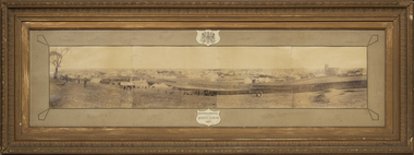
Photograph - Framed photograph of Warrnambool 1887, Town Panorama. Warrnambool Queen's Jubilee 1887, 1887
This is a framed photograph of a panoramic section of the Warrnambool township taken in 1887 to commemorate the Jubilee of the reign of Queen Victoria (1837-1887). The photograph is taken from Booval Hill (Liebig Street north) and shows the fencing in that area with groups of people in the foreground posing for the photograph. The panorama covers Liebig Street and Raglan Parade and includes private houses, a windmill and three tanks, St. John's Church, St. Joseph's Church, Tattersalls Hotel and the Saleyards.This photograph provides us with historical information on a section of the Warrnambool township in 1887 and is a valuable resource for researchers.This is a black and white photograph in a brown wooden frame and enclosed in glass. The photograph has a gilt metal edging outlined with ornate kite-shaped pieces on the corners and depicts a section of a town from an elevated position. At the top of the photograph is a crest in a shield shape and at the bottom is another shield shape containing the title of the photograph. The left centre section of the photograph is splotched or water-stained.Warrnambool Queen's Jubilee 1887warrnambool 1887, queen victoria's jubilee -
 Ringwood and District Historical Society
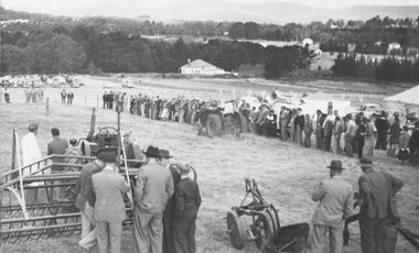
Photograph, Ford Industry Field Day - Loughnan's Hill, Ringwood - April, 1952
Black and white photographWritten on backing sheet- "Mail 10 April 1952. Ford Industry comes to Ringwood. Panoramic view of field day organised and arranged by Allan Coffey Motors showing tractors in operation slashing grass." Included with image- Copy of article in Ringwood Mail dated April 10, 1952,agriculture -
 Ithacan Historical Society
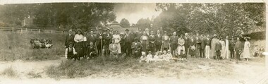
Photograph, Picnic Group, 1920s
From the outset the Ithacan Philanthropic held at least one family picnic a year. They either took place at a popular seaside locations or at popular picnic sites in the nearby hills around Melbourne. The first annual picnic was held in 1918. The Ithacan Greeks worked long hours in family food and restaurant businesses in Melbourne. On Sundays the shops were closed so it was seen as an opportunity to relax outdoors away from the city. The Ithacan Philanthropic Society continues this tradition holding an annual picnic in late summer.A black and white panoramic photograph of a large picnic group of men, women and children standing in an open area with trees around the perimeter. Eight children are sitting on the ground in front of the adults and a group of ladies are sitting on a bench to the left of the group. Some of the party are holding long walking sticks which must have been used when they went on a hike or walk.families, picnics, leisure time. -
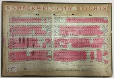 Kew Historical Society Inc
Plan - Subdivision Plan, Jas R Mathers Son & McMillan, Camberwell City Heights, 1922
"Following the 1919 amalgamation of suburban tramway trusts, an electrified tram service extended along Doncaster Road. Housing estates such as the 1919 Balwyn Park Estate, 1922 Hillcrest Estate and the Camberwell City Heights Estate, also 1922, quickly followed. These estates were built over by expansive suburban villas, set in fine gardens and along tree-lined streets. North Balwyn, largely constructed since 1933, was typified by even grander houses, many of them in the 'ocean liner' style and seen at their most distinctive in the Riverview Estate." (Source; 'Balwyn' in eMelbourne)Portions of subdivision plan mounted on both sides of cardboard sheet. Coloured pink, probably to show allotments sold. Area covered: Doncaster Road, Mountainview Road, Panoramic Road, Cityview Road, Longview Road, Riverview Road, Hillview Road, Bulleen Road. Includes location diagram showing railway lines and existing and proposed tram routes.Cardboard backing has advertisement for "Tillock's soluble coffee"subdivision plans -- camberwell (vic.), camberwell city heights subdivision -
 Kew Historical Society Inc
Plan - Subdivision Plan, Pointed Firs Estate, 1936
The Kew Historical Society collection includes almost 100 subdivision plans pertaining to suburbs of the City of Melbourne. Most of these are of Kew, Kew East or Studley Park, although a smaller number are plans of Camberwell, Deepdene, Balwyn and Hawthorn. It is believed that the majority of the plans were gifted to the Society by persons connected with the real estate firm - J. R. Mathers and McMillan, 136 Cotham Road, Kew. The Plans in the collection are rarely in pristine form, being working plans on which the agent would write notes and record lots sold and the prices of these. The subdivision plans are historically significant examples of the growth of urban Melbourne from the beginning of the 20th Century up until the 1980s. A number of the plans are double-sided and often include a photograph on the reverse. A number of the latter are by noted photographers such as J.E. Barnes.An almost identical plan of the ‘Pointed Firs Estate’ is in the State Library of Victoria. The plan unusually uses a photograph to show the panoramic views from the Estate. A prospective purchaser could expect to look across the Yarra Valley to Eaglemont and Heidelberg. The 36 lots advertised for sale faced Doncaster Road, Houghton Street, Maud Street and Thackray Street in Balwyn North.subdivision plans - balwyn, pointed firs estate -
 Kew Historical Society Inc
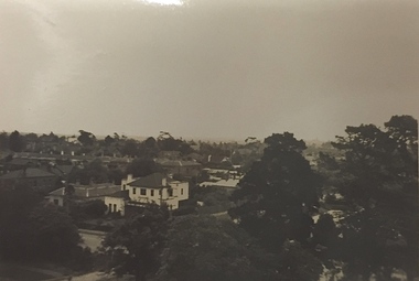
Photograph - Studley Park (Kew), c.1949
An item forming part of a collection of costumes, photographs and documents relating to the Weir family who lived in a mansion, originally named Illapa, at 84 Princess Street, Kew, from c.1917 to 1950. This historically significant collection includes items relating to both George Weir (1866-1937), his wife Edith Mary Weir (1867-1948) and their children. George Weir attained national prominence in the mining industry, becoming General Manager of the North Broken Hill Silver Mining Company in 1903 (later renamed North Broken Hill Mining Company 1905-12, and North Broken Hill Ltd 1912-1988), and subsequently President of the Mine Owners Association. He was to remain General Manager of North Broken Hill Ltd until his retirement in 1926.Small black and white photograph of a panoramic view from the tower of 84 Princess Street, Kew during the occupation of the house by the Weir family during the years 1918-1950. The house and garden had formerly been named Illapa and then Parcnacilla. In 1950 the family sold the house to a religious order who renamed the house 'The Towers'. It now forms part of 'Rylands'.illapa -- 84 princess street -- kew (vic.), aerial photographs -- kew (vic.), studley park (kew) -1930s -
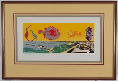 Glenelg Shire Council Cultural Collection
Print, Portland Pier, 1983
CEMA Art Collection Part of "A Community View" 150 years in Portland Screenprint Exhibition. Part of Angela Gee Residency 1983 and 1984.Screenprint depicting a panoramic view of Portland Harbour and coastline in lower half. Top half of work features five enlarged sea creatures on a yellow background. The creatures are (from left to right): two seahorses; a side view of a fish; a bug; and a front view of a fish. Mounted on yellow matt with purple highlight and sage edging. Wooden and gold frame with glass glazingFront: Portland Pier 30/70 (lower left) A Gee 83 (lower right) (pencil) -
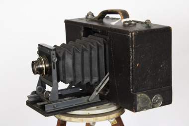 Lorne Historical Society
Tool - Cirkut Panoramic Camera Number 5, Circa 1915
This camera was designed by William Johnston in 1904. Production began in 1905. There were many versions, the number indicated the length of film which corresponds to the width of the panorama. Originally designed for photography of large groups of people. Later it was used for landscapes. This camera was used by the local Lorne photographer William Anderson who took photographs of visitors and local scenes. William purchased Norman Brown’s photographic business in December 1899 and worked in Lorne until his death in 1948It is a large format rotating panoramic camera. A concertinaed fine leather tube with the adjustable lens is contained in a black wooden leatherette covered rectangular box. On the top is a metal winding handle, a series of weights and a carrying handle. The lens is a Gundlach - Manhattan rapid recto graph. The camera rotates on a geared tripod through 360 degrees with the film driven past the exposure slot by a clock work motor.cameras, lorne, william anderson, -
 Federation University Historical Collection
Photograph, Ballarat Looking Towards the Wesleyan Church
Panoramic view of Lydiard Street South in Ballarat from the intersection of Lydiard Street and Dana Street. The view shows the former Ballarat Supreme Court (later the Ballarat School of Mines), the Lydiard Street Wesleyan Church (later the Ballarat School of Mines Museum), the site of the Ballarat School of Mines Botanical Gardens, George Smith's Nursery, Ballarat Gaol. Details of the image are also depicted.ballarat school of mines, ballarat gaol, ballarat school of mines museum, ballarat school of mines botanical gardens, george smith, museum, ballarat wesleyan church, ballarat methodist church, lydiard street wesleyan church, c.smith nursery -
 National Wool Museum
Photograph - The Australian Eleven, 1935
"The Australian Eleven", from the display board which hung in the Geelong Wool Exchange, Corio St, Geelong until the building was sold in 1985. Sheep were from the "Wanganella" station in Victoria.Panoramic black and white photograph of eleven merino rams in full fleece, standing in a row in front of a wire fence. The photograph has a dark, tree-lined background and each side has been blackened out. Photograph is glued to cream cardboard. Bands of glue are visible where photograph has been fixed to mounting board. Grey paper pieces glued to the back of the cream board.merino sheep, sheep australian, pastoral industry history, geelong woolbrokers' association geelong wool exchange, western district, victoria, 'wanganella' victoria, sheep - australian, pastoral industry - history -
 Bendigo Military Museum
Letter - LETTERCARD WW1, c.1916
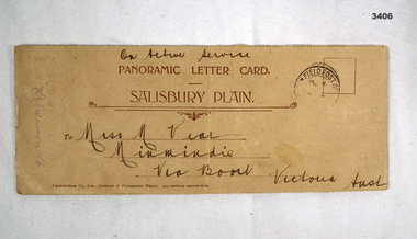
N Graham No 551, refer Cat No 266 for his service details.Cream, light cardboard covered booklet containing black & white photos of army camps & scenes around Salisbury. On front - "Black stamp RHS: Field Post Office" Brown printing: "PANORAMIC LETTER CARD SALISBURY PLAIN" Black handwriting: "On Active Service Miss M Vear Minmindie Via Boort Victoria Australia" Handwritten inside: "Best Wishes from N Graham Lark Hill Salisbury Plains 7/10/16"paorama, letter card, salibury, 38th -
 Ringwood and District Historical Society
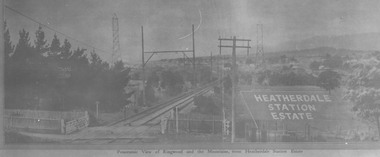
Photograph, View from where Heatherdale railway station is now situated, looking towards Ringwood - 2/2/1924. Land between Heatherdale Rd. and Madden St., sold 2nd Feb. 1924. J.B. McAlpin - agent"
Typed at bottom of photograph, "Panoramic view of Ringwood and the mountains, from Heatherdale Station Estate". Typed below photograph on mounting sheet, "View from where Heatherdale railway station is now looking towards Ringwood - 2/2/1924". "Between Heatherdale Rd. and Madden St., sold 2nd Feb. 1924. J.B. McAlpin - agent". -
 Kew Historical Society Inc
Photograph, Garden of 'Rockingham', Kew, c.1870
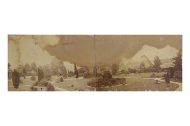
Built by John Bournane, Rockingham had a number of occupants before the newspaper magnate David Syme purchased it in 1902. The house in the 1860s and ‘70s was comprised of nine rooms, and was surrounded by a veranda on the front and sides. It was approached from the Kew road by the curve in front of the Hon. S.G. Henty’s mansion of ‘Findon’.In 1955, the Syme family sold Rockingham to the Red Cross Society to be used as a convalescent home for returned servicemen. The house was sold, demolished, and the land subdivided in 1966.An early panoramic photograph of an early Kew mansion (now demolished), dating from the 1870s.A rare, panoramic photograph (c.1870) of the garden of ‘Rockingham’, during the occupation of the house by W. Gardiner Esq. Rockingham was located beside and above the Barkers Road cutting. The view of the garden in the photograph is of the terraces leading down to the Yarra River. At the time the photograph was taken, the property covered an area of “…nine acres of beautifully laid-out grounds, interspersed with numerous terraces leading down the sloping bank of the river”.rockingham, david syme, kew -
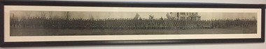 The 5th/6th Battalion Royal Victoria Regiment Historical Collection
Photograph - Panoramic, Framed
Large black and white panoramic photograph showing 124 French and 213 Australian Soldiers and officers formed up in front of a large house, presumably in France during the later part of the First World War. Centrally there are 2 Australian flags and a French Guidon to each flank there are two French guidons. There is a fold in the left side of the photo. The photograph is mounted behind white mounting board and is in a dark wooden frame.nilsoldiers, wwi, first world war, great war, french, france -
Port Melbourne Historical & Preservation Society
Sign, Alison KELLY, Vintage Port Worth Preserving, c.. 1984
Sign believed to have been made c.1984 as part of the campaign against amalgamation. Large oblong sign with 'Vintage Port' in white and "Worth Preserving' in red on a blue background. Top left has an image of a red topped shipping beacon. The sign has eyelet holes an each corner & in the centre to enable it to be hung. The reverse side has copies of two panoramic views from the late 1900's which were added at a later date & show the view from Station Pier to the city & the reverse.built environment - industrial, built environment - domestic, centenary bridge, commonwealth government engine works, beacon, piers and wharves - princes pier, piers and wharves - station pier, amalgamation -
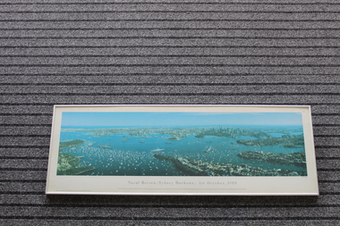 Lara RSL Sub Branch
Framed Print of Naval Review,Sydney Harbour, 1st October,1988, Naval Review,Sydney Harbour, 1st October,1988, 12/01/1990
The bicentenary of Australia was celebrated in 1988. It marked 200 years since the arrival of the First Fleet of British convict ships at Sydney in 1788. This aerial photo shows naval and pleasure craft in Sydney Harbour for the bicentennial celebrations.The bicentennial year marked Captain Arthur Phillip's arrival with the 11 ships of the First Fleet in Sydney Harbour in 1788, and the founding of the city of Sydney and the colony of New South Wales. 1988 is considered the official bicentenary year of the founding of Australia. Rectangular shaped glass covered picture frame showing photo of Naval Review, Sydney Harbour, 1st October,1988Naval Review, Sydney Harbour, 1st October,1988 This 140 degree panoramic photograph was taken from a helicopter by Phil Gray. It shows the visiting warships in the harbour including the USS New Jersey, FNS Colbert and HMS Ark Royal in the foreground.This print is the fourth in the Sydney Harbour Panorama series by Phil Gray who uses Kodak film.Printed in Australia.prints, naval photos, hms ships, sydney harbour, lara r.s.l. -
 Eltham District Historical Society Inc
Document, Prospectus: Kinloch Gardens, Eltham Victoria, 1998c
“Kinloch Gardens at Eltham, Victoria is planned as a comprehensively designed and cohesive residential environment.” “Only twelve innovatively designed houses ,will be situated within the established gardens and grounds of this historic Eltham estate. Building design and development will be under the control of the Kinloch Gardens design and construction team.” “Kinloch Gardens is situated on one of the highest points in Eltham and enjoys panoramic views in all directions.” “Kinloch Gardens lies hidden from the outside world behind high stone retaining walls, terraced embankments and extensive landscaping. The existing buildings, amongst the most significant of the Eltham / Montsalvat domestic building tradition are set in park like surrounds and enjoy panoramic views of the ranges to the north east and the city sky line to the west. New houses combined with sensitive landscaping will blend immediately into the established garden environment and will share the amenity and ambience of a very private and unique estate. The central theme of the landscape master plan is a garden reserve and a planted avenue terminating in a -small square.” “Houses vary in size from 120m2 (12.9 squares) to 210m2 (22.6 squares) (or larger) and include an extensive range of planning options. House types include: The Studio House The Tower House The Pergola House The Gallery House 'The Barn' is one of the existing buildings of Kinloch Gardens and is situated on the premium Lot 11.” Developer: Kinloch Pty Ltd. Project Managers: Creative Block Design Pty Ltd. Architects: Graeme Gunn and Ian Jelbart. Landscape Architect: Suzy Boyd. Builder: Vizarje Homes Pty Ltd. Surveyors and Engineers: Miller Merrigan.Digital file only; created from scan undertaken by EDHSarthur street, creative block design pty ltd., eltham, graeme gunn, houses, ian jelbart, kinloch gardens, kinloch pty ltd, miller merrigan, real estate, suzy boyd, vizarje homes pty ltd.