Showing 836 items
matching parish map
-
 Bendigo Historical Society Inc.
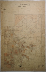
Map - NEILBOROUGH, 6/12/1882
... Map: Parish of Neilborough, County of Bendigo. Parish plan...MAP Bendigo parish plan Neilborough J A Morrison Jr. Harvey ...Map: Parish of Neilborough, County of Bendigo. Parish plan. J A Morrison Junior June 1877. Examined by ? Harvey 21/8/1877. Additions made by J V Walshe24/10/82. Examined by E D 39/10/82.map, bendigo, parish plan, neilborough, j a morrison jr., harvey, j v walshe -
 Bendigo Historical Society Inc.
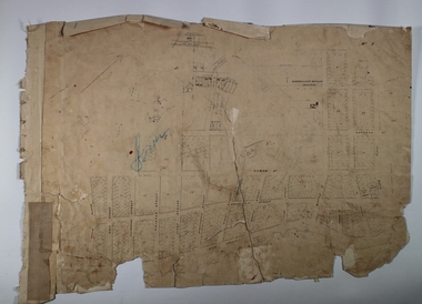
Map - BENDIGO (PART), No date visible
... of High St. between Ophir St. and View Place. Parish plan. Older...MAP Bendigo city streets Bendigo City Streets Sandhurst ...Map:Part of Sandhurst City streets, showing west side of High St. between Ophir St. and View Place. Parish plan. Older unidentifiable map on the reverse side.map, bendigo, city streets, bendigo city streets, sandhurst city streets -
 Bendigo Historical Society Inc.
Map - CAMPBELL COLLECTION: BENDIGO AND DISTRICT MAPS
... Map. Ellesmere, Parish of Ellesmere. Scale 20 chains to 1... Bendigo agricultural lands Map. Ellesmere, Parish of Ellesmere ...Map. Ellesmere, Parish of Ellesmere. Scale 20 chains to 1 inch. Total area 3926 acres. Prepared in W.P.B. from A and P plans. (number 354 in map cupboard 1)map, bendigo, agricultural lands -
Bendigo Historical Society Inc.
Map - PARISH OF STRATHFIELDSAYE : COUNTY OF BENDIGO, 1-10-19
... Map. Parish of Strathfieldsaye, County of Bendigo.... Map. Parish of Strathfieldsaye, County of Bendigo, Wellsford ...Map. Parish of Strathfieldsaye, County of Bendigo, Wellsford, Sandhurst, Sedgwick, Eppalock, Axedale. Photo-Lithographed at the Department of Lands and Survey, Melbourne by W.J.Butson, 1-10-19. Price 1/-. By authority A.J. Mullett, Government Printer, Melbourne. (number 34 in map cupboard 1)A.J. Mullett, Govt. Printer, Melbourne.map, bendigo, strathfieldsaye -
 Bendigo Historical Society Inc.
Map - CAMPBELL COLLECTION: BENDIGO AND DISTRICT MAPS
... Map. Parishes and suburbs : North of Bendigo, Parish...MAP Bendigo parishes Map. Parishes and suburbs : North ...Map. Parishes and suburbs : North of Bendigo, Parish of Huntly, Parish of Nerring, Parish of Sandhurst, Sydney Flat, Myers Flat, Borough of Eaglehawk, Sailors Gully, Jobs Gully, Harvey Town, California Gully, Maiden Gully, Long Gully, St.Just's Point, Iron Bark.map, bendigo, parishes -
 Linton and District Historical Society Inc
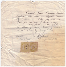
Receipt, Receipt for Payment for a Block of Land near Linton, 1918
... the Geelong Road (Linton-Naringhil Road). See map of Parish of Argyle... the Geelong Road (Linton-Naringhil Road). See map of Parish of Argyle ...Note that the block of land which was traded was not the block in Sussex Street, Linton on which the Sandows had a shop and house, but a block just outside the town boundary, near the Geelong Road (Linton-Naringhil Road). See map of Parish of Argyle for clarification.Photocopy of original handwritten receipt, which was for payment in full for a block of land situated just outside of Linton - Section A, Crown Allotment 1, Parish of Argyle. This land was purchased by Rubina (Ruby) Sandow from George Bolte in 1918. Receipt is for fifteen pounds, it is made out to "Rubinia Norwood Sandow" and is signed by Alf J. Smith, "for Geo. Bolte". Two Victorian Stamp Duty stamps are attached to the original document.rubina (ruby) sandow, george bolte, receipts, sale of land -
Bendigo Historical Society Inc.
Map - PARISH OF SHELBOURNE : COUNTY OF BENDIGO, 11-12-15
... Map. Parish of Shelbourne, County of Bendigo, Marong..., Melbourne. Map. Parish of Shelbourne, County of Bendigo, Marong ...Map. Parish of Shelbourne, County of Bendigo, Marong, Lockwood, Ravenswood, Bradford, Laanecoorie, Woodstock. Photographed at the Department of Lands and Survey, Melbourne by W.J.Butson, 11-12-15. Price 1/-. By authority Albert J. Mullett, Government Printer, Melbourne. (number 32 in map cupboard 1)Albert J. Mullett, Government Printer, Melbourne.map, bendigo, shelbourne -
Bendigo Historical Society Inc.
Map - CAMPBELL COLLECTION: BENDIGO AND DISTRICT MAPS, 12-2-29
... Map. Axedale, Parish of Ellesmere and Axedale, Total area... Bendigo agricultural lands W.J.Galbraith Map. Axedale, Parish ...Map. Axedale, Parish of Ellesmere and Axedale, Total area 4156 acres, Prepared in W.P.B. from A. and P. Plans by W.J. Galbraith 12-2-29. (number 383 in map cupboard 1)W.J.Galbraithmap, bendigo, agricultural lands -
Bendigo Historical Society Inc.
Map - CAMPBELL COLLECTION: BENDIGO AND DISTRICT MAPS, 15-2-29
... Map. Nerring, Parish of Nerring, scale 20 chains to 1 inch... Bendigo agricultural lands W.J.Galbraith Map. Nerring, Parish ...Map. Nerring, Parish of Nerring, scale 20 chains to 1 inch. Prepared in W.P.B. from A. and P. Plans by W.J. Galbraith. 15-2-29. (number 379 in map cupboard 1)W.J.Galbraithmap, bendigo, agricultural lands -
Bendigo Historical Society Inc.
Map - CAMPBELL COLLECTION: BENDIGO AND DISTRICT MAPS, 15-2-29
... Map. Nerring, Parish of Nerring, scale 20 chains to 1 inch... Bendigo parish plan W.J.Galbraith Map. Nerring, Parish of Nerring ...Map. Nerring, Parish of Nerring, scale 20 chains to 1 inch. Prepared in W.J.B. from A and B plans by W.J. Galbraith 15-2-29. (number 356 in map cupboard 1)W.J.Galbraithmap, bendigo, parish plan -
Bendigo Historical Society Inc.
Map - CAMPBELL COLLECTION: BENDIGO & DISTRICT MAPS, 2-2-29
... Map. Wellsford, Parishes of Wellsford and Axedale. Scale 20... Bendigo country lands W.J.Galbraith Map. Wellsford, Parishes ...Map. Wellsford, Parishes of Wellsford and Axedale. Scale 20 chains to 1 inch. Total area 4994 acres. Prepared in W.P.B. from A. and P. Plans by W.J.G. (number 377 in map cupboard 1)W.J.Galbraithmap, bendigo, country lands -
Bendigo Historical Society Inc.
Map - CAMPBELL COLLECTION: BENDIGO & DISTRICT MAPS, 16-5-29
... Map. Egerton, Parishes of Egerton and Whirrakee, scale 20... Bendigo agricultural lands W.J.Galbraith Map. Egerton, Parishes ...Map. Egerton, Parishes of Egerton and Whirrakee, scale 20 chains to 1 inch. Total area 5401 acres. Prepared in W.P.B. from A. and C.L. Plans by W.J. Galbraith (number 376 in map cupboard 1)W.J.Galbraithmap, bendigo, agricultural lands -
Bendigo Historical Society Inc.
Map - CAMPBELL COLLECTION: BENDIGO & DISTRICT MAPS, 5-4-28
... Map. Sedgwick, Parishes of Strathfieldsaye, Lyell... Bendigo agricultural lands W.J.Galbraith Map. Sedgwick, Parishes ...Map. Sedgwick, Parishes of Strathfieldsaye, Lyell and Sedgwick. Scale 20 chains to 1 inch.Total area 5372 acres. Prepared in W.P.B. from C.l. and A. Plans by W.J. Galbraith. (number 374 in map cupboard 1)W.J.Galbraithmap, bendigo, agricultural lands -
Bendigo Historical Society Inc.
Map - CAMPBELL COLLECTION: BENDIGO AND DISTRICT MAPS
... Map. Mandurang, Parish of Mandurang, Scale 20 chains to 1... Bendigo allotments Map. Mandurang, Parish of Mandurang, Scale 20 ...Map. Mandurang, Parish of Mandurang, Scale 20 chains to 1 inch. Total area 5993 acres, Northern Railway to left of map, Water Reserve (Spring Gully). (number 363 in map cupboard 1)map, bendigo, allotments -
Bendigo Historical Society Inc.
Map - CAMPBELL COLLECTION: BENDIGO AND DISTRICT MAPS
... Map. Lockwood, Parishes of Lockwood and Shelbourne, scale... Bendigo allotments Map. Lockwood, Parishes of Lockwood ...Map. Lockwood, Parishes of Lockwood and Shelbourne, scale 20 chains to 1 inch. Spring Creek centre of map and Bullock Creek to the right. Total area 4405 acres. (number 358 in map cupboard 1)map, bendigo, allotments -
Bendigo Historical Society Inc.
Map - CAMPBELL COLLECTION: BENDIGO AND DISTRICT MAPS
... Map. Eaglehawk, Parishes of Huntly and Nerring. Scale 20... Bendigo allotments Map. Eaglehawk, Parishes of Huntly and Nerring ...Map. Eaglehawk, Parishes of Huntly and Nerring. Scale 20 chains to 1 inch. Total area 6211 acres. Eaglehawk Kerang Railway, to Epsom 2 miles. Manure Depot. (number 390 in map cupboard 1)map, bendigo, allotments -
Bendigo Historical Society Inc.
Map - CAMPBELL COLLECTION: BENDIGO AND DISTRICT MAPS, 9-4-29
... Map. Campaspe, Parish of Kimbolton, Scale 20 chains to 1... Bendigo agricultural lands W.J.Galbraith Map. Campaspe, Parish ...Map. Campaspe, Parish of Kimbolton, Scale 20 chains to 1 inch. Total area 4117 acres, Campaspe River, Prepared in W.P.B. by W.J.Galbraith from Parish and Assessment Plans. (number 384 in map cupboard 1)W.J.Galbraithmap, bendigo, agricultural lands -
![Map, [Coornmill land area available for leasing for grazing, Parish of Coornmill]. Circa 1904](/media/collectors/5e461d8021ea67224c82f2a1/items/677cde147f2053f3e5d277c3/item-media/677cdeea7f2053f3e5d27bb4/item-fit-380x285.jpg) Bacchus Marsh & District Historical Society
Bacchus Marsh & District Historical SocietyMap, [Coornmill land area available for leasing for grazing, Parish of Coornmill]. Circa 1904
... in the Larderderg State Park area known as the Parish of Coornmill.The map... in the Larderderg State Park area known as the Parish of Coornmill.The map ...This map shows an area of land north of Bacchus Marsh in the Larderderg State Park area known as the Parish of Coornmill.The map indicates an area of land which was to be made available by public tender for grazing leaseholders. The plan to do this was discussed in the Bacchus Marsh Express newspaper on the 16 July, 1904, page 2, column 7. The area reserved for grazing leases is identified by red lines on the map. The Express described the area available for grazing was 12,000 acres.A single page paper map showing an area of land in the Parish of Corrnmill to be made available for grazing leases. A photo lithographed Lands Department Map. No scale indicated. The map is pasted into a bound volume containing 76 maps or plans in total. High resolution digital image stored on BMDHS computer network. coornmill parish maps, lerderderg state park maps, agriculture bacchus marsh area -
Bendigo Historical Society Inc.
Map - CAMPBELL COLLECTION: BENDIGO AND DISTRICT MAPS, 16-4-29
... Map. Kennington, Parishes of Sandhurst, Mandurang... Bendigo allotments W.J.Galbraith Map. Kennington, Parishes ...Map. Kennington, Parishes of Sandhurst, Mandurang and Strathfieldsaye. Scale 20 chains to 1 inch. Total area 2918 acres. Prepared in W.P.B. from A. and C.L. Plans by W.J.Galbraith, 16-4-29. (number 394 in map cupboard 1)W.J.Galbraithmap, bendigo, allotments -
Bendigo Historical Society Inc.
Map - CAMPBELL COLLECTION: BENDIGO & DISTRICT MAPS, 22-3 29
... Map. Marong, Parishes of Marong, Lockwood and Mandurang... Bendigo allotments G.W.L Map. Marong, Parishes of Marong, Lockwood ...Map. Marong, Parishes of Marong, Lockwood and Mandurang. Scale 20 chains to an inch. Total area 5106 acres. Crusoe Reservoir on right. Compiled in W.P.B. from Field Survey and Parish Plans (number 373 in map cupboard 1)G.W.Lmap, bendigo, allotments -
Bendigo Historical Society Inc.
Map - CAMPBELL COLLECTION: BENDIGO AND DISTRICT MAPS
... Map. Marong, Parishes of Marong, Lockwood and Mandurang... Bendigo parish plan Map. Marong, Parishes of Marong, Lockwood ...Map. Marong, Parishes of Marong, Lockwood and Mandurang. Scale 20 chains to an inch. Total 5106 acres. Compiled in W.P.B. from Field Survey and Parish Plans. Crusoe Reservoir to the right of map. (number 362 in map cupboard 1)map, bendigo, parish plan -
Bendigo Historical Society Inc.
Map - CAMPBELL COLLECTION: BENDIGO AND DISTRICT MAPS, 6-4-28
... Map. Sedgwick, Parishes of Strathfieldsaye, Lyell... Bendigo agricultural lands W.J.Galbraith. Map. Sedgwick, Parishes ...Map. Sedgwick, Parishes of Strathfieldsaye, Lyell, and Sedgwick. Scale 20 chains to 1 inch. Total area 5372 acres. Prepared in W.P.B. from C.L.and A. Plans by W.J.Galbraith 6-4-28. (number 400 in map cupboard 1)W.J.Galbraith.map, bendigo, agricultural lands -
Bendigo Historical Society Inc.
Map - DIGGORRA : COUNTY OF BENDIGO, 26-6-36
... Map. Parish of Diggorra, County of Bendigo, Parish... Bendigo diggorra H.J. Green, Govt. Printer. Map. Parish ...Map. Parish of Diggorra, County of Bendigo, Parish of Ballendella, Parish of Pannoobamawm, Pannoomilloo, Rochester West, Warragamba, Minto, Egerton, Elmore, Northern Railway to Echuca, Elmore and Cohuna Railway, Township of Elmore. By authority H.J. Green, Govt. Printer. Photo-Lithographed at the Deptartment of Lands and Survey, Melbourne. 26-5-36. (number 58 in map cupboard 1)H.J. Green, Govt. Printer.map, bendigo, diggorra -
Bendigo Historical Society Inc.
Map - CAMPBELL COLLECTION: BENDIGO AND DISTRICT MAPS, 11-4-29
... Map. Huntly, Parishes of Huntly Nerring and Neilborough... Bendigo agricultural lands W.J.Galbraith Map. Huntly, Parishes ...Map. Huntly, Parishes of Huntly Nerring and Neilborough. Scale 20 chains to 1 inch. Total area 4738 acres. Eaglehawk. Prepared in W.J.B. from A. and C.L. Plans by W.J.Galbraith 11-4-29. (number 396 in map cupboard 1)W.J.Galbraithmap, bendigo, agricultural lands -
Bendigo Historical Society Inc.
Map - CAMPBELL COLLECTION: BENDIGO AND DISTRICT MAPS, 14-6-29
... Map. Terricks, Parish of Terrick Terrick West, scale 20... Bendigo agricultural lands W.J.Galbraith Map. Terricks, Parish ...Map. Terricks, Parish of Terrick Terrick West, scale 20 chains to 1 inch, total area 6318 acres, prepared in W.P.B. from Assessment and Parish Plans by W.J.G. 14-6-29. (number 388 in map cupboard 1)W.J.Galbraithmap, bendigo, agricultural lands -
Bendigo Historical Society Inc.
Map - CAMPBELL COLLECTION: BENDIGO AND DISTRICT MAPS
... Map. Kimbolton, Parishes of Kimbolton and Lyell, scale 20... Bendigo allotments Map. Kimbolton, Parishes of Kimbolton and Lyell ...Map. Kimbolton, Parishes of Kimbolton and Lyell, scale 20 chains to 1 inch. Area by Planimeter 6258 acres. Knowsley. 10 1/2 miles to Strathfieldsaye. Campaspe River at bottom right of map. (number 365 in map cupboard 1)map, bendigo, allotments -
Bendigo Historical Society Inc.
Map - CAMPBELL COLLECTION: BENDIGO AND DISTRICT MAPS, 8-2-29
... Map. Bagshot, Parishes of Wellsford, Ellesmere, and Bagshot... Bendigo agricultural lands .W.J.Galbraith Map. Bagshot, Parishes ...Map. Bagshot, Parishes of Wellsford, Ellesmere, and Bagshot. Huntly 4 miles, Fosterville 3 miles. Total area 5037 acres, Prepared in W.P.B. from A.C.L and D.B. Plans, by W.J.Galbraith 8-2-29. (number 382 in map cupboard 1).W.J.Galbraithmap, bendigo, agricultural lands -
Bendigo Historical Society Inc.
Map - CAMPBELL COLLECTION: BENDIGO AND DISTRICT MAPS, 30-1-29
... Map. Ellesmere, Parish of Ellesmere, scale 20 chains to 1... Bendigo agricultural lands W.J.Galbraith Map. Ellesmere, Parish ...Map. Ellesmere, Parish of Ellesmere, scale 20 chains to 1 inch. Total area 3926 acres. Prepared in W.P.B. from A. and P. Plans, by W.J. Galbraith, 30-1-29, to Bendigo along Fosterville. (number 381 in map cupboard 1)W.J.Galbraithmap, bendigo, agricultural lands -
Bendigo Historical Society Inc.
Map - CAMPBELL COLLECTION: BENDIGO AND DISTRICT MAPS, 16-5-29
... Map. Egerton, Parishes of Egerton and Whirrakee. Scale 20... Bendigo allotments W.J.G.(W.J.Galbraith) Map. Egerton, Parishes ...Map. Egerton, Parishes of Egerton and Whirrakee. Scale 20 chains to 1 inch. Total area 5401 acres. Prepared in W.P.B. from A. and C.L. Plans by W.J.G. 16-5-29. To Rochester 12 miles. (number 366 in map cupboard 1)W.J.G.(W.J.Galbraith)map, bendigo, allotments -
Bendigo Historical Society Inc.
Map - CAMPBELL COLLECTION: BENDIGO AND DISTRICT MAPS, 8-2-29
... Map. Bagshot, Parishes of Wellsford, Ellesmere and Bagshot... Bendigo agricultural lands W.J.Galbraith Map. Bagshot, Parishes ...Map. Bagshot, Parishes of Wellsford, Ellesmere and Bagshot. Scale 20 chains to 1 inch. Total area 5037 acres. Prepared in W.P.B. from A.C.l. and D.B. Plans, W.J. Galbraith, 8-2-29 (number 353 in map cupboard 1)W.J.Galbraithmap, bendigo, agricultural lands