Showing 247 items
matching public garden reserve
-
 Friends of Ballarat Botanical Gardens History Group
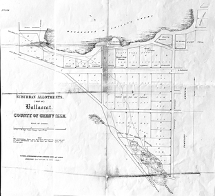
Work on paper - Suburban Allotments (west of) Ballaarat, Wendouree or Yuille's Swamp, County of Grenville 30/4/1856, 30/4/1856. No date given for photocopy
This map of the 1856 survey shows the numbered suburban allotments and the boundaries surrounding this area including Wendouree or Yuilles's Swamp close to where the Ballarat Botanical Gardens and the Lake exist today. This map gives a clear idea of an early survey of this western area and directions to areas of Ballarat surrounding these allotments.2 pages of the same map, except p.2 shows the Township Reserve on the lefthand side of the page. On the back of p.2, righthand corner is the Public Records Stamp.P2, righthand corner is the citation in pencil.john garner, doctor john garner, ballarat botanical gardens, friends of ballarat botanical gardens, map of western suburban allotments 1856, county of grenville, public record office of victoria, john garner collection, gardens, ballarat -
 City of Kingston
Photograph - Colour, 6 March 1993
Edithvale is a suburb in the City of Kingston. It is located between Aspendale and Chelsea on the Port Phillip Bay and built within remnant areas of the Carrum Carrum swamp. The foreshore precinct comprises a wide sandy beach, with low sand dunes and numerous historic boat sheds. The suburb consists of older style dwellings and former holiday houses, combined with mid-century housing and newer homes. The large blocks are increasingly subdivided and the existing dwellings demolished to accommodate units and townhouses, thus changing the landscape of the area and reducing the tree canopy.The beachside suburb of Edithvale was previously part of the extensive Carrum Carrum Swamp. The area was once a source of fish and eels for the Mayone-Bulluk clan of the Bunurong people. Over time the area was drained and predominantly devoted to dairy farming and holiday houses. The farms were gradually sold and subdivided with a large number of homes built after World War II and in the 1960s. Edithvale is mainly residential with a shopping strip along Nepean Highway but little significant industry was ever established in the area apart from a plaster works and confectionary factory, both now closed.Laminated aerial colour photograph of Edithvale as viewed from Alexandra Avenue in the north to Ella Grove Chelsea/Edithvale in the south. regents Park Aspendale can be seen in the top left. The area is built-up with residential housing and facilities including Edithvale Primary School, numerous churches and the Edithvale Railway station. Large sections depict the remnant Carrum Carrum swamp. Edithvale Common and the former "Duck Inn" (Melbourne Water/Friends of Edithvale Seaford Wetlands) can be seen. Edithvale Recreational reserve, the valodrome and Edithvale Public Golf Course are prominent. The image shows vacant land in the area now known as Aspendale Gardens and the newer residential section of Chelsea Heights is not developed. A bike path has been established to cover the secondary drain. The Golf Links Court residential development located off Hughes Avenue is a large vacant block.Black type on white adhesive label: 6-3-93 Black type on white adhesive label: 25/9211, 6/3/93, 11.20 am Black type on white adhesive label: 9211 Yellow circular adhesive sticker Black pencil: 9211 6-3-93 arrow pointing Nedthvale, carrum carrum swamp, aspendale, chelsea -
 Bendigo Historical Society Inc.
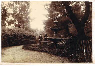
Photograph - FOUNTAIN IN ROSLIND PARK
Photograph - black and white. Written on back of photo -' Fountain in Rosalind Park, old camp reserve. Violet and Mr Baker'. The photo shows a three tier fountain, water emitting from top, surrounded by a simple metal fence. Man and woman standing alongside fence looking at fountain, presumably Violet and Mr. Baker.place, public gardens, rosalind park, fountain in roslind park. bendigo. violet and mr baker. -
Federation University Historical Collection
Book - Report, Ballarat School of Mines Conservation Management Plan, 2016, 2016
The Ballarat School of Mines was the first school of mines in Australasia, and is a predecessor institution of Federation University Australia.CD-ROM of the SMB Campus Conservation Management plan, and a printout of the 390 page Draft report on the Federation University SMB Campus. Contents include: Establishment of the Wesleyan church Reserve Selection of a Site for the Ballarat Gaol and Court House Building the Court of Mines The Gaol Culvert The Ballarat School of Mines Establishment Ballarat iron Workers' Association Ballarat Technical Art School Ballarat School of Mines Museum Acquisition of Lewin's Land The Ballarat School of Mines site in c1970 Master Planning Flecknoe Biulding The Ballarat School of Mines in 1988 Architectects Caselli, Figgus, Molloy and Smith. Public Work Department Architects Ballarat School of Mines Botanical Garden Former Ballarat Junior Technical School Administration Building - Building A W.J. Gribble Building (Ballarat Technical Art School) - Building B Old Chemistry Building Building C Amenities Building, Governor's Quarters, Gaol Gatehouse and Watch Tower and Gaol Walls - Building D Courthouse Theatre (Former Ballarat Supreme Court) - Building F A.W. Steane Building (Former Ballarat Junior Technical School) - Building J Flecknoe Building and E.J. Barker Building (Building N) Old Plumbing Building - Builidng ) Unistyle Haridressing Building (Formerly Ballarat School of Mines Museum and Wesleyan Church) - Building P david rowe, wendy jacobs, ballarat school of mines conservation management plan, ballarat school of mines, buildings, wesleyan church reserve, former ballarat gaol, court of mines, circuit courthouse, gal culvert, ballarat school of mines museum, ballarat technical art school, x-rays, ballarat junior technical school, motor mechanics, wool classing, former governor's quarters, library, flecknoe building, former supreme court, architects, henry richards caselli, figgis, molloy and smith, public work department architects, ballarat school of mines botanic garden, former ballarat junior technical school commemorative gardem, w.j. gribble building, old chemistry building, amenities building, former warden's quarters, courthouse theatre, a.w. steane building, old plumbing building, unistyle hairdressing building, former ballarat post office, post office gallery, former ballarat government offices, cmp, conservation management plan, ballarat school of mines campus, smb campus -
City of Kingston
Photograph - Colour, Circa 1993
Edithvale is a suburb in the City of Kingston. It is located between Aspendale and Chelsea on the Port Phillip Bay and built within remnant areas of the Carrum Carrum swamp. The foreshore precinct comprises a wide sandy beach, with low sand dunes and numerous historic boat sheds. The suburb consists of older style dwellings and former holiday houses, combined with mid-century housing and newer homes. The large blocks are increasingly subdivided and the existing dwellings demolished to accommodate units and townhouses, thus changing the landscape of the area and reducing the tree canopy.The beachside suburb of Edithvale was previously part of the extensive Carrum Carrum Swamp. The area was once a source of fish and eels for the Mayone-Bulluk clan of the Bunurong people. Over time the area was drained and predominantly devoted to dairy farming and holiday houses. The farms were gradually sold and subdivided with a large number of homes built after World War II and in the 1960s. Edithvale is mainly residential with a shopping strip along Nepean Highway but little significant industry was ever established in the area apart from a plaster works and confectionary factory, both now closed.Aerial colour photograph of Edithvale as viewed from Alexandra Avenue in the north to Ella Grove Chelsea/Edithvale in the south. The area is built-up with residential housing and facilities including Edithvale Primary School, numerous churches and the Edithvale Railway station. Large sections depict the remnant Carrum Carrum swamp. Edithvale Common and the former "Duck Inn" (Melbourne Water/Friends of Edithvale Seaford Wetlands) can be seen. Edithvale Recreational reserve, the velodrome and Edithvale Public Golf Course are prominent. The image shows vacant land in the area now known as Aspendale Gardens and the newer residential section of Chelsea Heights is not developed. A bike path has been established to cover the secondary drain. The Golf Links Court residential development located off Hughes Avenue is a large vacant block.Yellow circular adhesive sticker on plastic Black ink (marker): * (asterisk) Black type on white adhesive sticker: P000108edithvale, aspendale, chelsea, carrum carrum swamp -
Bendigo Historical Society Inc.
Postcard - BENDIGO POSTCARDS x 5
Five sepia postcards of Bendigo - St. Paul's Church, Bendigo; Queen's Reserve, Bendigo; St. Andrew's Presbyterian Church and School, Bendigo; The Orphanage, Bendigo; and Conservatory Gardens, Bendigo. 'C & L Series' and 'Semco Series', Bendigo. Early 1900's. Unused, and no writing on the reverse of the postcards. May have been connected with the Waterworth family. St. Paul's Church: St Paul's Cathedral, Bendigo was built in stages. The nave was built in 1868, the tower in 1872-73 and the transepts and sanctuary in 1926-27. Robert Love was the architect, although the final stage was supervised by architects Gawler and Drummond. Cathedral status was transferred from the original cathedral All Saints to St Paul's in 1981. The Gothic style cathedral is constructed of red brick with stone dressings. It has a simple cruciform plan comprising a six bay nave, transepts and sanctuary. A tall tower centrally located at the west end dominates the exterior. The peal of eight bells was cast by Meares and Co of London and installed in 1873. The interior features elaborately cusped roof principals; an organ by Alfred Fuller built in 1883 with a console and pipes added later from St Andrew's Cathedral, Sydney; and notable stained glass by Ferguson, Urie and Lyon. St Paul's Rectory was built in 1885 to a design by the architect W C Vahland. The Parish Office and Hall was built as a Sunday School in 1898 to a design by F W Lehmann. Queen's Reserve: Now known as part of the Bendigo Botanic Gardens, Rosalind Park, Pall Mall. In 1851, the gold rush transformed the area and eventually the mullock heaps became the most prominent public park in Bendigo. Rosalind Park was added to the Victorian Heritage Register in 2000 for its historic, archaeological, aesthetic, scientific (botanical) and architectural significance to the state of Victoria. The statue of Queen Victoria dates to 1903. St. Andrew's Presbyterian Church: Opened in 1859 as part of the Presbyterian Church, St. Andrew's. Union of the Presbyterian, Methodist and Congregational Churches in 1977 saw this church join the Uniting Church. Located in Myers Street, Bendigo. The Orphanage: The Convent of the Good Shepherd, Bendigo was established in 1905. It was established at the request of the Bishop to cater for children in the diocese of Bendigo (although it housed children from other areas as well). It was also known as St Aidan’s Orphanage, and was the only Good Shepherd Convent in Australia to care for boys. The section named St Aidan’s accommodated girls aged up to around 16 years, as well as boys aged up to around 11. Maryfields housed girls and women aged from around 15 years. The Convent ceased to operate as a residential facility for children in 1981. A number of women with disabilities remained at the Convent until it closed in 1984. Conservatory Gardens: Now known as part of the Bendigo Botanic Gardens, Rosalind Park, Pall Mall. In 1851, the gold rush transformed the area and eventually the mullock heaps became the most prominent public park in Bendigo. Rosalind Park was added to the Victorian Heritage Register in 2000 for its historic, archaeological, aesthetic, scientific (botanical) and architectural significance to the state of Victoria. The Conservatory Gardens feature an ornate 19th century Conservatory building, erected in 1897 - this was the last building of its type in a public park in Victoria. bendigo, gardens, buildings, chinese, church -
 University of Melbourne, Burnley Campus Archives
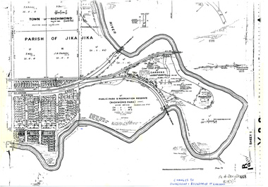
Plan, Allan & Tuxen et al, Public Park & Recreation Reserve (Richmond Park), 1886-1996
Shows changes in ownership of various parts of Richmond Park and Burnley Gardens including University of Melbourne, Amrad, Melbourne City Link, etc. from gazettal in 1873 to 1996Photocopy of plan of Richmond Park and Burnley Gardens with University of Melbourne land acquisition 13.10.1994 hand drawn on it, dates Act revoked and Gazette numbers. Based on plan of Parish of Jika Jika R 19 (3)"Changes to ownership & boundaries of Gardens" in inkpublic parks, recreation reserve, richmond, parish if jika jika, burnley gardens, horticultural society of victoria