Showing 798 items
matching rural road
-
 Greensborough Historical Society
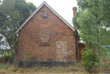
Photograph - Digital Image, Bundoora Primary School Bu1915 (old building) 4, 18/03/2014
Bundoora Primary School No.1915 was constructed in 1877 of brick on a bluestone base with an iron roof and small porch. The school consisted of a single room with the dimensions 30 feet by 18 feet. It was a small rural school and in use for over 100 years. Today it sits abandoned at the intersection of Plenty Road and the Metropolitan Ring Road. The School has a Victorian Heritage Overlay (no H062) Photograph by Marilyn Smith 2014. Update: The old building has been incorporated into a childcare facility.Digital copy of colour photograph. bundoora primary school, bundoora state school -
 Greensborough Historical Society
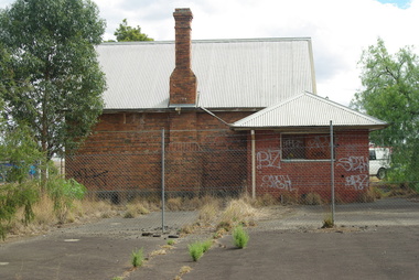
Photograph - Digital Image, Bundoora Primary School Bu1915 (old building) 5, 18/03/2014
Bundoora Primary School No.1915 was constructed in 1877 of brick on a bluestone base with an iron roof and small porch. The school consisted of a single room with the dimensions 30 feet by 18 feet. It was a small rural school and in use for over 100 years. Today it sits abandoned at the intersection of Plenty Road and the Metropolitan Ring Road. The School has a Victorian Heritage Overlay (no H062) Photograph by Marilyn Smith 2014. Update: The old building has been incorporated into a childcare facility.Digital copy of colour photograph. bundoora primary school, bundoora state school -
 Greensborough Historical Society
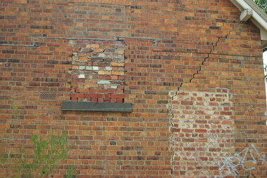
Photograph - Digital Image, Bundoora Primary School Bu1915 (old building) 6, 18/03/2014
Bundoora Primary School No.1915 was constructed in 1877 of brick on a bluestone base with an iron roof and small porch. The school consisted of a single room with the dimensions 30 feet by 18 feet. It was a small rural school and in use for over 100 years. Today it sits abandoned at the intersection of Plenty Road and the Metropolitan Ring Road. The School has a Victorian Heritage Overlay (no H062) Photograph by Marilyn Smith 2014. Update: The old building has been incorporated into a childcare facility.Digital copy of colour photograph. bundoora primary school, bundoora state school -
 Greensborough Historical Society
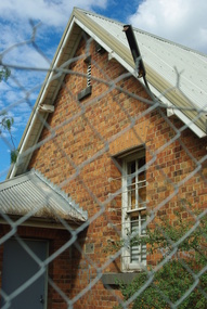
Photograph - Digital Image, Bundoora Primary School Bu1915 (old building) 7, 18/03/2014
Bundoora Primary School No.1915 was constructed in 1877 of brick on a bluestone base with an iron roof and small porch. The school consisted of a single room with the dimensions 30 feet by 18 feet. It was a small rural school and in use for over 100 years. Today it sits abandoned at the intersection of Plenty Road and the Metropolitan Ring Road. The School has a Victorian Heritage Overlay (no H062) Photograph by Marilyn Smith 2014. Update: The old building has been incorporated into a childcare facility.Digital copy of colour photograph. bundoora primary school, bundoora state school -
 Greensborough Historical Society
Notebook - Digital Image, David Medhurst's notebook, 1930s, 1930-1932
David Medhurst (senior) ran a fruit shop in Grimshaw Street Greensborough and also reported on local events for the Hurstbridge "Advertiser" during the 1930s. This notebook, in the collection of his descendants, contains newspaper clippings of his articles and handwritten notes detailing payment for his work. The page shown is an example only; there are 54 similar pages in the collection.The importance of these clippings lies in their clarity as some copies on the Trove database are almost illegible.They also provide a snapshot of life in the 'rural' township of Greensborough in the 1930s.Scanned copy of 54 pages of handwritten notes and pasted newspaper clippings.Hand written notes throughout.david medhurst, hurstbridge advertiser -
 Greensborough Historical Society
Map, Saxam Heritage Overlay, 2011_
"Saxam" was the home of the Kaye family (1886-1888) then William Santon, a former councillor and Mayor of Heidelberg. Saxam Homestead is a distinctive and substantial timber homestead built in the late 1880s as one of the notable rural properties in the St Helena area. In 2014 the house still stands but is in poor condition with most interior features removed. The site had a heritage overlay as shown. The overlay was reduced in 2014 to protect the house while allowing residential development on the site.Saxam is one of the only remaining farmhouses in the Greensborough area.Copy of map and planning scheme.saxam -
 Greensborough Historical Society
Plan, Plan of Manatunga Circuit Greensborough subdivision, 1970_
Plan of Manatunga Circuit subdivision. Prepared by O'Connor and Beveridge (land surveyors) for Development Underwriting (developers). Plan of subdivision. Part of Crown Portion 3. Parish of Nillumbik, County of Evelyn.An original example of a subdivision plan in the expanding suburb of Greensborough. The 1960s and 1970s saw this area develop from a rural farming area to a suburb.Plan of subdivision. Printed on buff paper, hand coloured. Mounted on cardboard. Includes 2 small cards attached.Various handwritten comments. Small cards from Survey Branch, Office of Titles.greensborough, manatunga circuit, diamond creek road, plenty river drive -
 Greensborough Historical Society
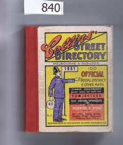
Book, Collins' Street Directory: Melbourne & suburbs 1951, 1951_
This 1951 street directory covers many Melbourne suburbs but not Greensborough. In the 1950s Greensborough was still a rural settlement. This directory is interesting for anyone wanting to check mid-20th century developments.A comprehensive coverage of suburban, inner city streets.Street directory. 411 pages, maps.melbourne, street directories -
 Greensborough Historical Society
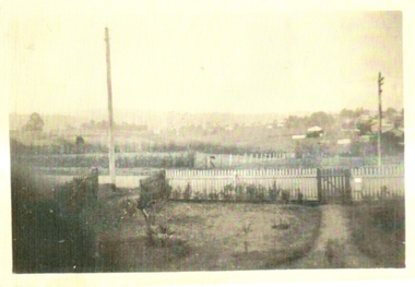
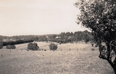
Photograph, Greensborough from the Godwill home, 1935c
This was taken by Gordon Godwill in the mid 1930s.The photograph was taken from the Godwill home in Williams Street Greensborough. It shows a rural view of the area where the Greensborough Plaza now stands.A black and white photograph.Nilgodwill, williams st, greensborough plaza, 1930's -
 Greensborough Historical Society
Oral History, John Gibson et al, The Big Paddock: Eric Barclay / as told to John Gibson, 1940o
Eric Barclay relates his life in Greensborough from the 1940s, living in Grace Park. The story was written from an interview by John Gibson. Photographs courtesy of Eric Barclay.A primary source relating to life in rural Greensborough mid-20th Century.10 pages, text and colour and black and white photos.eric barclay, grace park -
 Greensborough Historical Society
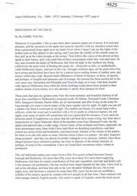
Article, The Argus, Procession of the fruit, by Blamire Young, 02/02/1907
This article, written by noted artist Blamire Young, is a lyrical description of carts bringing produce from the Greensborough area to market. Young lived in Greensborough 1906-1908A description of Greensborough as a rural area in the early 20th centuryTypescript transcription of article in the Argus, Saturday 2 February 1907. 4 p. text and photographdiamond valley, horticulture, blamire young -
 Greensborough Historical Society
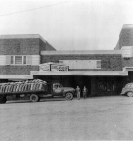
Photograph - Digital image, Stubley's Hay and Grain Store, 1937c
Stubley's Hay and Grain Store circa 1950. The Stubley Group began in 1946 when Purcell Stubley purchased a site with petrol bowsers in Main Street from 'Snowy' Jessop. In 1948 Purcell began building the new Stubley Motors, working round the old site to keep the business operating. It was completed in 1951. The Group expanded into other areas such as this Hay and Grain Store, to serve the semi-rural area of Greensborough and surrounds.Digital copy of black and white photographpurcell stubley, stubley motors, stubley group greensborough -
 Greensborough Historical Society
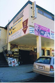
Photograph - Digital image, Frank Solomon, Greensborough Grain Store, rear Main Street, 04/06/2010
Greensborough Grain Store, rear Main Street. This business is one of the last examples of Greensborough's rural past.Digital copy of colour photographmain street greensborough, greensborough grain store -
 Greensborough Historical Society
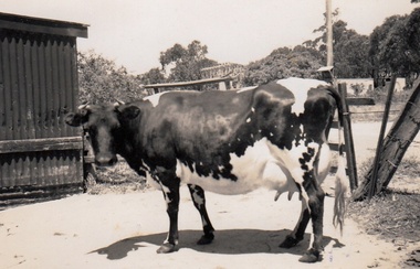
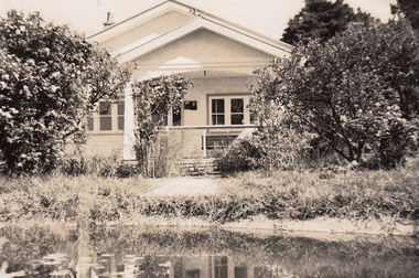
Photograph - Digital Image, Cherel Sartori, Cows at Kell's Cottage 1956, 01/01/1956
Photograph of a cow at Kell's Cottage in the 1940s. The house was built 1917, at 112 Henry Street Greensborough by William Mitchell on the 60 acre dairy farm owned by Ethel and Walter Kell. This collection of photographs was copied by Cherel Sartori (who owned the house from 1990-2000), following a visit by Claude Amiet who lived in the house as a child in the early 20th century.An indication of the rural aspect of this area in the mid-20th century.Digital copy of black and white photographkell's cottage, claude amiet, cherel sartori -
 Greensborough Historical Society
Photograph - Digital Image, Cherel Sartori, Looking east from Henry Street to the river 1956, 01/01/1956
Looking from Henry Street east to the Plenty River, 1956. The house was built 1917, at 112 Henry Street Greensborough by William Mitchell on the 60 acre dairy farm owned by Ethel and Walter Kell. This collection of photographs was copied by Cherel Sartori (who owned the house from 1990-2000), following a visit by Claude Amiet who lived in the house as a child in the early 20th century.An indication of the rural aspect of this area in the mid-20th century.Digital copy of black and white photographkell's cottage, claude amiet, cherel sartori -
 Greensborough Historical Society
Photograph - Digital Image, Cherel Sartori, Electricity connected in Henry Street, 1950s, 1956c
Kell's Cottage with electricity connected 1950s. The house was built 1917, at 112 Henry Street Greensborough by William Mitchell on the 60 acre dairy farm owned by Ethel and Walter Kell. This collection of photographs was copied by Cherel Sartori (who owned the house from 1990-2000), following a visit by Claude Amiet who lived in the house as a child in the early 20th century.An indication of the rural aspect of this area in the mid-20th century.Digital copy of black and white photographkell's cottage, claude amiet, cherel sartori -
 Greensborough Historical Society
Photograph - Digital Image, Cherel Sartori, Paddock and gates in Henry Street, 1950s, 1956c
Paddock and driveway at Kell's Cottage 1950s. The house was built 1917, at 112 Henry Street Greensborough by William Mitchell on the 60 acre dairy farm owned by Ethel and Walter Kell. This collection of photographs was copied by Cherel Sartori (who owned the house from 1990-2000), following a visit by Claude Amiet who lived in the house as a child in the early 20th century.An indication of the rural aspect of this area in the mid-20th century.Digital copy of black and white photographkell's cottage, claude amiet, cherel sartori -
 Glenelg Shire Council Cultural Collection
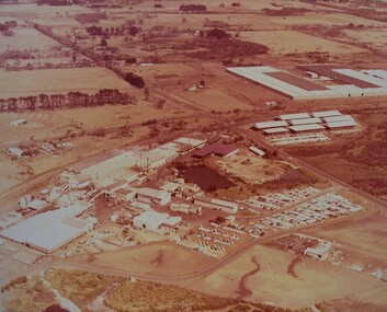
Photograph - Photograph - Borthwicks, 1960s
Glenelg Shire Council records.Aerial photograph of Thomas Borthwick and Sons abattoir, Portland.Back: Photographers stamp - not complete.borthwicks, abattoir, rural, industry -
Glenelg Shire Council Cultural Collection
Photograph - Photograph - Rural Scene two men standing on bank of waterway, n.d
Black and white photo attached to heavy card. Lighter area around print. Rural scene, two men standing on bank of waterway.Back: 'largo/fargo Class 1' - black ink -
 Glenelg Shire Council Cultural Collection
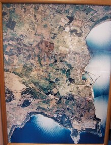
Photograph - Photograph - aerial view of Portland, 1988
Census Project No. 1995. Portland Dec. 1988.Aerial view of the "City of Portland" and surrounding rural area to a scale of 1:10,000 Aerial Photomosaic of Portland Bay, 1988Front: (no inscriptions) Back: (no inscriptions)aerial photography, central portland, portland harbour -
Glenelg Shire Council Cultural Collection
Booklet - Tourist Guide, VICTORIAN RAILWAYS PRINTING WORKS LAURENS STREET NORTH MELBOURNE VIC, Where to go in Victoria, c. 1935
Promotional booklet produced by the Victorian Government Tourist Bureau and published and printed by the Australian Railways Advertising Division and Printing Works. 'Where to go in Victoria' hotel and guesthouse guide, soft cover, full colour depiction of a steam train with carriages travelling through rural scene. Booklet and pictures black and white.tourism, visitor economy, travel -
Glenelg Shire Council Cultural Collection
Photograph - Photograph - stone cottage, n.d
... Cliff Street Portland great-ocean-road cottage photography rural ...Black and white photograph, old stone cottage, tin roof; wooden building beside it, wooden paling fenceBack: '14' crossed out, '15' in pencilcottage, photography, rural -
Glenelg Shire Council Cultural Collection
Sign - Sign - Portland Pure Creamery, n.d
... Cliff Street Portland great-ocean-road dairy industry rural ...Metal sign for Portland Pure Creamerydairy industry, rural, cream, creamery, advertising -
Glenelg Shire Council Cultural Collection
Map - Map - Glenelg River, 1975
Laminated map, Glenelg River - Casterton, proposed flood level and lines to be designated. Photograph of map taken in 1975. Produced by Rural Water Commission to Shire Engineer, Casterton, attached to reverse of map.flood, flood levels, casterton -
Glenelg Shire Council Cultural Collection
Photograph - Photograph - Heywood Show, n.d
Black and white photo of the Heywood Show at the Heywood Reserve.Back: 'Heywood Show' - handwritten in pencilheywood, glenelg shire, heywood show, rural show, agricultural show -
Glenelg Shire Council Cultural Collection
Photograph - Photograph - rural scene, Glenelg Shire, n.d
... Cliff Street Portland great-ocean-road photography rural scene ...Coloured photograph of a road, car in foreground, trees and houses on sides of road - unidentifiedphotography, rural scene, landscape -
Glenelg Shire Council Cultural Collection
Photograph - Photograph - Road bridge over a creek, n.d
... a creek, rural setting. Photograph Photograph - Road bridge over ...Black and white photo of road bridge over a creek, rural setting.Front: '1903' - handwritten, blue pen -
Glenelg Shire Council Cultural Collection
Photograph - Photograph - Heywood Show, n.d
... Cliff Street Portland great-ocean-road rural show agricultural ...Black and white photo of the Heywood Show at the Heywood ReserveFront: 'Heywood Show' - handwritten, pencilrural show, agricultural show, heywood -
Glenelg Shire Council Cultural Collection
Document - Charity Ball Ticket - Portland Benevolent Asylum and Hospital, n.d
Benevolent asylums were places that housed anyone who could not support themselves; these were usually the aged, infirm, disabled and destitute. Benevolent Asylums also served as immigrants' homes, blind asylums, orphanages, lying-in hospitals and lunatic asylums. Benevolent asylums were often associated with hospitals in rural towns; they have evolved into aged care homes and hospitals in larger towns. Portland Benevolent Asylum and Hospital was founded in 1849.Pale blue card ticket, rounded corners, gold edge, black print and script Charity ball in aid of the Bazaar fund on behalf of the Portland Benevolent Asylum and hospital. Double ticket 7s. 6dBack: '75' - black penportland benevolent asylum and hospital, social care, welfare -
Glenelg Shire Council Cultural Collection
Document - Ticket - Charity Ball, Portland Benevolent Asylum and Hospital, n.d
Benevolent asylums were places that housed anyone who could not support themselves; these were usually the aged, infirm, disabled and destitute. Benevolent Asylums also served as immigrants' homes, blind asylums, orphanages, lying-in hospitals and lunatic asylums. Benevolent asylums were often associated with hospitals in rural towns; they have evolved into aged care homes and hospitals in larger towns. Portland Benevolent Asylum and Hospital was founded in 1849.Pale blue card ticket, rounded corners, gold edge, black print, and script Charity Ball in aid of the Bazaar Fund on behalf of the Portland benevolent Asylum and hospital Double 7s6dBack: '80' black penasylum, social care, benevolent, charity, fundraising