Showing 281 items
matching service street bridge
-
 Kew Historical Society Inc
Journal, The Kewriosity Sheet Vol.3 No.3 : September 1981
Home tutors for migrants [Jill Manton] / p1. Harp, Browse and Buy [Harp Browse and Buy Shop; Victoria Schizophrenia Fellowship] / p1. East Kew Uniting Church / p1. Spring-time Fair [East Kew Uniting Church] /p2. Do you know? [Parents of Disabled Persons] / p2. What's doing in Kew for September / p2&3 Women's Recreation Program /p3. Guest to preach at Kew Baptist Church [Rev. Brian Willersdorf] / p3. Minibus drivers and jockeys [Meals on Wheels] / p3. Hyde Park Fellowship [Hyde Park Church] / p3. Mission Spring Fair [Missionary Sisters of St Peter Claver / p3. The gateway to Kew [Charles Grimes Expedition; Johnston Street Bridge; Studley Park Road; Raheen; Campion Hall; Burke Hall; Studley House; Villa Alba] / Elizabeth Mackie p4. Council News - Family and Community Services (FACS) Programme; Community Service Grants; Deafness Awareness Week; ] / p4.The Kewriosity Sheet (1979-83) was first published in the City of Kew (Victoria) in June 1979 as a two-sided 'community newssheet'. It aimed to: 'share news about Kew happenings and Kew people, and to exchange ideas about living in Kew'. Later issues gradually evolved into a 4-page, quarto sized publication. The Kewriosity Sheet was superseded by the Kew Council publication 'Kewriosity' (1983-1994).non-fictionHome tutors for migrants [Jill Manton] / p1. Harp, Browse and Buy [Harp Browse and Buy Shop; Victoria Schizophrenia Fellowship] / p1. East Kew Uniting Church / p1. Spring-time Fair [East Kew Uniting Church] /p2. Do you know? [Parents of Disabled Persons] / p2. What's doing in Kew for September / p2&3 Women's Recreation Program /p3. Guest to preach at Kew Baptist Church [Rev. Brian Willersdorf] / p3. Minibus drivers and jockeys [Meals on Wheels] / p3. Hyde Park Fellowship [Hyde Park Church] / p3. Mission Spring Fair [Missionary Sisters of St Peter Claver / p3. The gateway to Kew [Charles Grimes Expedition; Johnston Street Bridge; Studley Park Road; Raheen; Campion Hall; Burke Hall; Studley House; Villa Alba] / Elizabeth Mackie p4. Council News - Family and Community Services (FACS) Programme; Community Service Grants; Deafness Awareness Week; ] / p4. community publications --- kew (vic.), the kewriosity sheet, newsletters - kew (vic.) -
 Kew Historical Society Inc
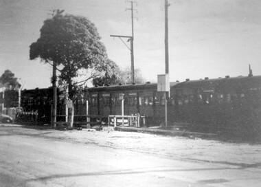
Photograph - The last train at Barker Station, 1952
The Kew railway was opened in 1887, and diverged from the main (Box Hill–Lilydale) line about half-way between Hawthorn and Glenferrie. From the point of divergence the line was slightly less than one mile long, and it had only one intermediate station — Barker. There were four road over-bridges and two level crossings, including one over the busy Barkers Road. The line supported a passenger and goods service, and was electrified in December 1922, at the same time as the main line to Box Hill. There were a number of peak hour services which ran from Flinders Street station (Melbourne) to Kew, but in 1938 all but one of these were diverted to the Ashburton line, where traffic was growing. This had an adverse effect on Kew traffic, as passengers from Kew needed to cross over a footbridge at Hawthorn to change trains, and the main line trains were usually already crowded by the time they reached Hawthorn. At about the same time the off-peak trains were replaced by road buses. In 1952 all passenger trains were withdrawn, but the road bus service continued for many years. Goods trains were finally withdrawn in 1957, and the railway was dismantled in 1958-59. (Source: Frank Stamford, 'The Hawthorn - Kew Railway')Small black and white snapshot of the last passenger train at Barker Railway Station in 1952. The photograph, one of 12, is part of a larger album of newspaper clippings, timetables, tickets and photos relating to the Kew Railway Line, taken and compiled by Lachlan Richardson, while a resident of Kew. The album dates from the 1950s. The album is part of a larger subject file on the Kew Line, compiled over time by members of the Kew Historical Society."Last train at Barker Station / 1 August 1952"kew railway line, transport -- railways -- kew (vic.), barker railway station, kew branch line -
 Kew Historical Society Inc
Photograph - Barker Station, August 1952
The Kew railway was opened in 1887, and diverged from the main (Box Hill–Lilydale) line about half-way between Hawthorn and Glenferrie. From the point of divergence the line was slightly less than one mile long, and it had only one intermediate station — Barker. There were four road over-bridges and two level crossings, including one over the busy Barkers Road. The line supported a passenger and goods service, and was electrified in December 1922, at the same time as the main line to Box Hill. There were a number of peak hour services which ran from Flinders Street station (Melbourne) to Kew, but in 1938 all but one of these were diverted to the Ashburton line, where traffic was growing. This had an adverse effect on Kew traffic, as passengers from Kew needed to cross over a footbridge at Hawthorn to change trains, and the main line trains were usually already crowded by the time they reached Hawthorn. At about the same time the off-peak trains were replaced by road buses. In 1952 all passenger trains were withdrawn, but the road bus service continued for many years. Goods trains were finally withdrawn in 1957, and the railway was dismantled in 1958-59. (Source: Frank Stamford, 'The Hawthorn - Kew Railway')Small black and white snapshot of the last passenger train at Barker Railway Station in 1952. The photograph, one of 12, is part of a larger album of newspaper clippings, timetables, tickets and photos relating to the Kew Railway Line, taken and compiled by Lachlan Richardson, while a resident of Kew. The album dates from the 1950s. The album is part of a larger subject file on the Kew Line, compiled over time by members of the Kew Historical Society."Barker Station / August 1952"kew railway line, transport -- railways -- kew (vic.), barker railway station, kew branch line -
 Kew Historical Society Inc
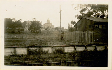
Photograph - Kew Railway Station: Denmark Street entrance, 1952
The Kew railway was opened in 1887, and diverged from the main (Box Hill–Lilydale) line about half-way between Hawthorn and Glenferrie. From the point of divergence the line was slightly less than one mile long, and it had only one intermediate station — Barker. There were four road over-bridges and two level crossings, including one over the busy Barkers Road. The line supported a passenger and goods service, and was electrified in December 1922, at the same time as the main line to Box Hill. There were a number of peak hour services which ran from Flinders Street station (Melbourne) to Kew, but in 1938 all but one of these were diverted to the Ashburton line, where traffic was growing. This had an adverse effect on Kew traffic, as passengers from Kew needed to cross over a footbridge at Hawthorn to change trains, and the main line trains were usually already crowded by the time they reached Hawthorn. At about the same time the off-peak trains were replaced by road buses. In 1952 all passenger trains were withdrawn, but the road bus service continued for many years. Goods trains were finally withdrawn in 1957, and the railway was dismantled in 1958-59. (Source: Frank Stamford, 'The Hawthorn - Kew Railway')Small black and white snapshot of the entrance to Kew Station from Denmark Street in 1952. The photograph, one of 12, is part of a larger album of newspaper clippings, timetables, tickets and photos relating to the Kew Railway Line, taken and compiled by Lachlan Richardson, while a resident of Kew. The album dates from the 1950s. The album is part of a larger subject file on the Kew Line, compiled over time by members of the Kew Historical Society.kew railway line, transport -- railways -- kew (vic.), kew branch line, kew railway station -
 Kew Historical Society Inc
Photograph - Kew Station 22/4/51, F3
The Kew railway was opened in 1887, and diverged from the main (Box Hill–Lilydale) line about half-way between Hawthorn and Glenferrie. From the point of divergence the line was slightly less than one mile long, and it had only one intermediate station — Barker. There were four road over-bridges and two level crossings, including one over the busy Barkers Road. The line supported a passenger and goods service, and was electrified in December 1922, at the same time as the main line to Box Hill. There were a number of peak hour services which ran from Flinders Street station (Melbourne) to Kew, but in 1938 all but one of these were diverted to the Ashburton line, where traffic was growing. This had an adverse effect on Kew traffic, as passengers from Kew needed to cross over a footbridge at Hawthorn to change trains, and the main line trains were usually already crowded by the time they reached Hawthorn. At about the same time the off-peak trains were replaced by road buses. In 1952 all passenger trains were withdrawn, but the road bus service continued for many years. Goods trains were finally withdrawn in 1957, and the railway was dismantled in 1958-59. (Source: Frank Stamford, 'The Hawthorn - Kew Railway')Small black and white snapshot of Kew Railway Station, looking south to Barker Station. The photograph, one of 12, is part of a larger album of newspaper clippings, timetables, tickets and photos relating to the Kew Railway Line, taken and compiled by Lachlan Richardson, while a resident of Kew. The album dates from the 1950s. The album is part of a larger subject file on the Kew Line, compiled over time by members of the Kew Historical Society.kew railway line, transport -- railways -- kew (vic.), kew branch line, kew railway station -
 Kew Historical Society Inc
Photograph - Kew Branch Line : The Hawthorn Grove crossing, August 1952
The Kew railway was opened in 1887, and diverged from the main (Box Hill–Lilydale) line about half-way between Hawthorn and Glenferrie. From the point of divergence the line was slightly less than one mile long, and it had only one intermediate station — Barker. There were four road over-bridges and two level crossings, including one over the busy Barkers Road. The line supported a passenger and goods service, and was electrified in December 1922, at the same time as the main line to Box Hill. There were a number of peak hour services which ran from Flinders Street station (Melbourne) to Kew, but in 1938 all but one of these were diverted to the Ashburton line, where traffic was growing. This had an adverse effect on Kew traffic, as passengers from Kew needed to cross over a footbridge at Hawthorn to change trains, and the main line trains were usually already crowded by the time they reached Hawthorn. At about the same time the off-peak trains were replaced by road buses. In 1952 all passenger trains were withdrawn, but the road bus service continued for many years. Goods trains were finally withdrawn in 1957, and the railway was dismantled in 1958-59. (Source: Frank Stamford, 'The Hawthorn - Kew Railway')Small black and white snapshot of the Hawthorn Grove crossing, August 1952. The photograph, one of 12, is part of a larger album of newspaper clippings, timetables, tickets and photos relating to the Kew Railway Line, taken and compiled by Lachlan Richardson, while a resident of Kew. The album dates from the 1950s. The album is part of a larger subject file on the Kew Line, compiled over time by members of the Kew Historical Society.kew railway line, transport -- railways -- kew (vic.), kew branch line, hawthorn grove -- hawthorn (vic.), railway crossings -
 Kew Historical Society Inc
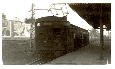
Photograph - Seven Carriage Train at Barker Station
The Kew railway was opened in 1887, and diverged from the main (Box Hill–Lilydale) line about half-way between Hawthorn and Glenferrie. From the point of divergence the line was slightly less than one mile long, and it had only one intermediate station — Barker. There were four road over-bridges and two level crossings, including one over the busy Barkers Road. The line supported a passenger and goods service, and was electrified in December 1922, at the same time as the main line to Box Hill. There were a number of peak hour services which ran from Flinders Street station (Melbourne) to Kew, but in 1938 all but one of these were diverted to the Ashburton line, where traffic was growing. This had an adverse effect on Kew traffic, as passengers from Kew needed to cross over a footbridge at Hawthorn to change trains, and the main line trains were usually already crowded by the time they reached Hawthorn. At about the same time the off-peak trains were replaced by road buses. In 1952 all passenger trains were withdrawn, but the road bus service continued for many years. Goods trains were finally withdrawn in 1957, and the railway was dismantled in 1958-59. (Source: Frank Stamford, 'The Hawthorn - Kew Railway')Small black and white snapshot of a seven carriage train approaching Barker Railway Station. The photograph, one of 12, is part of a larger album of newspaper clippings, timetables, tickets and photos relating to the Kew Railway Line, taken and compiled by Lachlan Richardson, while a resident of Kew. The album dates from the 1950s. The album is part of a larger subject file on the Kew Line, compiled over time by members of the Kew Historical Society."Seven Carriage Train at Barker Station"kew railway line, transport -- railways -- kew (vic.), barker railway station, kew branch line -
 Kew Historical Society Inc
Photograph - Farewell to 'Our Lady of Fatima'. Xavier College 22/4/51
The Kew railway was opened in 1887, and diverged from the main (Box Hill–Lilydale) line about half-way between Hawthorn and Glenferrie. From the point of divergence the line was slightly less than one mile long, and it had only one intermediate station — Barker. There were four road over-bridges and two level crossings, including one over the busy Barkers Road. The line supported a passenger and goods service, and was electrified in December 1922, at the same time as the main line to Box Hill. There were a number of peak hour services which ran from Flinders Street station (Melbourne) to Kew, but in 1938 all but one of these were diverted to the Ashburton line, where traffic was growing. This had an adverse effect on Kew traffic, as passengers from Kew needed to cross over a footbridge at Hawthorn to change trains, and the main line trains were usually already crowded by the time they reached Hawthorn. At about the same time the off-peak trains were replaced by road buses. In 1952 all passenger trains were withdrawn, but the road bus service continued for many years. Goods trains were finally withdrawn in 1957, and the railway was dismantled in 1958-59. (Source: Frank Stamford, 'The Hawthorn - Kew Railway')Small black and white snapshot of a train leaving Kew Station with the Xavier Chapel on the hill in the background, hence the ironic title provided by the photographer. The photograph, one of 12, is part of a larger album of newspaper clippings, timetables, tickets and photos relating to the Kew Railway Line, taken and compiled by Lachlan Richardson, while a resident of Kew. The album dates from the 1950s. The album is part of a larger subject file on the Kew Line, compiled over time by members of the Kew Historical Society."Farewell to 'Our Lady of Fatima'. Xavier College 22/4/51"kew railway line, transport -- railways -- kew (vic.), kew branch line, xavier college, kew railway station -
 Kew Historical Society Inc
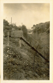
Photograph - Kew Branch Line: Looking along cutting towards Barker Station 22/4/51
The Kew railway was opened in 1887, and diverged from the main (Box Hill–Lilydale) line about half-way between Hawthorn and Glenferrie. From the point of divergence the line was slightly less than one mile long, and it had only one intermediate station — Barker. There were four road over-bridges and two level crossings, including one over the busy Barkers Road. The line supported a passenger and goods service, and was electrified in December 1922, at the same time as the main line to Box Hill. There were a number of peak hour services which ran from Flinders Street station (Melbourne) to Kew, but in 1938 all but one of these were diverted to the Ashburton line, where traffic was growing. This had an adverse effect on Kew traffic, as passengers from Kew needed to cross over a footbridge at Hawthorn to change trains, and the main line trains were usually already crowded by the time they reached Hawthorn. At about the same time the off-peak trains were replaced by road buses. In 1952 all passenger trains were withdrawn, but the road bus service continued for many years. Goods trains were finally withdrawn in 1957, and the railway was dismantled in 1958-59. (Source: Frank Stamford, 'The Hawthorn - Kew Railway')Small black and white snapshot looking along cutting towards Barker Station 22/4/51. The photograph, one of 12, is part of a larger album of newspaper clippings, timetables, tickets and photos relating to the Kew Railway Line, taken and compiled by Lachlan Richardson, while a resident of Kew. The album dates from the 1950s. The album is part of a larger subject file on the Kew Line, compiled over time by members of the Kew Historical Society."Looking along cutting towards Barker Station 22/4/51"kew railway line, transport -- railways -- kew (vic.), barker railway station, kew branch line -
 Kew Historical Society Inc
Photograph - The last train at Kew Station, August 1952
The Kew railway was opened in 1887, and diverged from the main (Box Hill–Lilydale) line about half-way between Hawthorn and Glenferrie. From the point of divergence the line was slightly less than one mile long, and it had only one intermediate station — Barker. There were four road over-bridges and two level crossings, including one over the busy Barkers Road. The line supported a passenger and goods service, and was electrified in December 1922, at the same time as the main line to Box Hill. There were a number of peak hour services which ran from Flinders Street station (Melbourne) to Kew, but in 1938 all but one of these were diverted to the Ashburton line, where traffic was growing. This had an adverse effect on Kew traffic, as passengers from Kew needed to cross over a footbridge at Hawthorn to change trains, and the main line trains were usually already crowded by the time they reached Hawthorn. At about the same time the off-peak trains were replaced by road buses. In 1952 all passenger trains were withdrawn, but the road bus service continued for many years. Goods trains were finally withdrawn in 1957, and the railway was dismantled in 1958-59. (Source: Frank Stamford, 'The Hawthorn - Kew Railway')Small black and white snapshot of the last passenger train at Kew Railway Station in 1952. The photograph, one of 12, is part of a larger album of newspaper clippings, timetables, tickets and photos relating to the Kew Railway Line, taken and compiled by Lachlan Richardson, while a resident of Kew. The album dates from the 1950s. The album is part of a larger subject file on the Kew Line, compiled over time by members of the Kew Historical Society."The last train at Kew Station, August 1952"kew railway line, transport -- railways -- kew (vic.), kew branch line, kew railway station -
 Kew Historical Society Inc
Photograph - Kew Branch Line: Weeds at Kew Station 14/51
The Kew railway was opened in 1887, and diverged from the main (Box Hill–Lilydale) line about half-way between Hawthorn and Glenferrie. From the point of divergence the line was slightly less than one mile long, and it had only one intermediate station — Barker. There were four road over-bridges and two level crossings, including one over the busy Barkers Road. The line supported a passenger and goods service, and was electrified in December 1922, at the same time as the main line to Box Hill. There were a number of peak hour services which ran from Flinders Street station (Melbourne) to Kew, but in 1938 all but one of these were diverted to the Ashburton line, where traffic was growing. This had an adverse effect on Kew traffic, as passengers from Kew needed to cross over a footbridge at Hawthorn to change trains, and the main line trains were usually already crowded by the time they reached Hawthorn. At about the same time the off-peak trains were replaced by road buses. In 1952 all passenger trains were withdrawn, but the road bus service continued for many years. Goods trains were finally withdrawn in 1957, and the railway was dismantled in 1958-59. (Source: Frank Stamford, 'The Hawthorn - Kew Railway')Small black and white snapshot of how the Kew Branch Line was allowed to run down. The photograph, one of 12, is part of a larger album of newspaper clippings, timetables, tickets and photos relating to the Kew Railway Line, taken and compiled by Lachlan Richardson, while a resident of Kew. The album dates from the 1950s. The album is part of a larger subject file on the Kew Line, compiled over time by members of the Kew Historical Society.kew railway line, transport -- railways -- kew (vic.), barker railway station, kew branch line -
 Kew Historical Society Inc
Photograph - Kew Railway Station, May 1950
The Kew railway was opened in 1887, and diverged from the main (Box Hill–Lilydale) line about half-way between Hawthorn and Glenferrie. From the point of divergence the line was slightly less than one mile long, and it had only one intermediate station — Barker. There were four road over-bridges and two level crossings, including one over the busy Barkers Road. The line supported a passenger and goods service, and was electrified in December 1922, at the same time as the main line to Box Hill. There were a number of peak hour services which ran from Flinders Street station (Melbourne) to Kew, but in 1938 all but one of these were diverted to the Ashburton line, where traffic was growing. This had an adverse effect on Kew traffic, as passengers from Kew needed to cross over a footbridge at Hawthorn to change trains, and the main line trains were usually already crowded by the time they reached Hawthorn. At about the same time the off-peak trains were replaced by road buses. In 1952 all passenger trains were withdrawn, but the road bus service continued for many years. Goods trains were finally withdrawn in 1957, and the railway was dismantled in 1958-59. (Source: Frank Stamford, 'The Hawthorn - Kew Railway')Small black and white snapshot of Kew Railway Station inMay 1950. The photograph, one of 12, is part of a larger album of newspaper clippings, timetables, tickets and photos relating to the Kew Railway Line, taken and compiled by Lachlan Richardson, while a resident of Kew. The album dates from the 1950s. The album is part of a larger subject file on the Kew Line, compiled over time by members of the Kew Historical Society."Kew Railway Station, May 1950"kew railway line, transport -- railways -- kew (vic.), kew branch line, kew railway station -
 Kew Historical Society Inc
Photograph - Kew Railway Station, 1951
The Kew railway was opened in 1887, and diverged from the main (Box Hill–Lilydale) line about half-way between Hawthorn and Glenferrie. From the point of divergence the line was slightly less than one mile long, and it had only one intermediate station — Barker. There were four road over-bridges and two level crossings, including one over the busy Barkers Road. The line supported a passenger and goods service, and was electrified in December 1922, at the same time as the main line to Box Hill. There were a number of peak hour services which ran from Flinders Street station (Melbourne) to Kew, but in 1938 all but one of these were diverted to the Ashburton line, where traffic was growing. This had an adverse effect on Kew traffic, as passengers from Kew needed to cross over a footbridge at Hawthorn to change trains, and the main line trains were usually already crowded by the time they reached Hawthorn. At about the same time the off-peak trains were replaced by road buses. In 1952 all passenger trains were withdrawn, but the road bus service continued for many years. Goods trains were finally withdrawn in 1957, and the railway was dismantled in 1958-59. (Source: Frank Stamford, 'The Hawthorn - Kew Railway')Small black and white snapshot of Kew Railway Station in 1950. The photograph, one of 12, is part of a larger album of newspaper clippings, timetables, tickets and photos relating to the Kew Railway Line, taken and compiled by Lachlan Richardson, while a resident of Kew. The album dates from the 1950s. The album is part of a larger subject file on the Kew Line, compiled over time by members of the Kew Historical Society."Kew Station / 14/51 / 22/4/51 F5"kew railway line, transport -- railways -- kew (vic.), kew branch line, kew railway station -
 Kew Historical Society Inc
Postcard, R McGeehan, The Effect of Storm. Train Passing Through Flood Waters, South Yarra, 25-1-07, 1907
SHARP DOWNPOUR. ONE INCH IN 45 MINUTES. SOUTHERN SUBURBS DELUGED. TRAIN STOPPED AT SOUTH YARRA. One of the sudden downpours of rain which occasionally fall in Melbourne occurred yesterday afternoon, when nearly an inch of rain fell in the course of three quarters of an hour, and caused a flood for an hour or two in certain localities. During the early part of the day, the sky had been clouded over, but there was nothing to indicate a storm of such intensity as that which followed. At about half-past 1 o'clock residents of South Yarra, South Melbourne, Prahran, and St. Kilda noticed a few drops of rain. Still, it appeared unlikely that there would be anything exceptional, until with startling suddenness at about 10 minutes to 1 o'clock, one of the heaviest downpours within the memory of residents burst upon those suburbs. A strange feature of the storm was that it was practically confined to an area of about three miles square. The city was but little affected, though at a spot as close as the Observatory 86 points of rain were recorded in three-quarters of an hour. Thunder and lightning accompanied the downpour, which was cyclonic in character, the rain driving heavily from all points of the compass as the cyclone passed. It was in South Yarra and Prahran that the rain fell heaviest. Within a few minutes after it commenced, the low-lying portions of Toorak-road and practically the whole length of Chapel-street were under water. The depression at the intersection of Toorak-road and Darling-street speedily filled to the dimensions of a small lake. Several shops were inundated, while the water from the higher levels rushed down like a mountain torrent, and in several in-stances swept through the rear of houses and shops, carrying furniture in a floating mass against the further walls. In one case a footbridge was carried bodily away and dashed to pieces. Darling-street itself Great Davis-street, and other low-lying and flat thoroughfares in the vicinity became flooded from kerb to kerb, while on the other side of the railway-bridge the valley between Kensington-road and River-street became filled for some minutes to a depth of several feet. Meanwhile the waters from South Yarra hill, seeking a lower level, found it in the railway cutting, and the excavations from South Yarra station to Prahran on the one line, and to the Chapel-street bridge on the other, were converted into a couple of canals. At the platforms at South Yarra the water was two feet deep on the permanent way, and towards Hawksburn, at the sudden depression under Chapel-street bridge, it was at one time deep enough to cover a tall man's head. Into this swirling mass of water the 1:50 p.m. train from Oakleigh plunged on its way to Melbourne. The impact caused a mighty fountain of water to rise to a height of about 20 feet above the level of Chapel-street and send clouds of spray in all directions. Under the belief that a terrible explosion had occurred residents braved the rain and rushed to the spot, only to find that the train had been brought to a stand-still in the middle of what seemed to be a river. The water was so high that it had entered the fire-box from below, extinguishing the fires and cutting off the steam supply. In the meantime the officials at the South Yarra station had been preparing for emergencies. Inspectors were on duty at intervals along the line, and the moment the alarm was given an extra engine was backed carefully down and continued on to connect with the stranded train without losing its own power. There was a delay of about ten minutes in the service for an hour or two, but by 5 o'clock all the trains were running on time again, and the water had run off all but the spot beneath the Chapel-street bridge. Here the water remained about four feet deep until nightfall, and throughout the afternoon several hundreds of people including biograph operators and photographers, were gathered around watching each train pass through. Even with the water two feet lower, this was a work attended with considerable difficulty. Each train had to absolutely force its way through the weight of water, almost enveloped by the spray thrown up, and it was only just able to negotiate the "ford" by using every ounce of steam. ... The Argus, 26 January 1907, p19.The item forms part of the Laurie Bennett collection of thirty-six postcards and photographs of Kew and early Melbourne, donated to the Kew Historical Society in 1980. The postcards in the Bennett collection, like other images in the Society's holdings date from the 1890s to the present and comprehensively indicate points-of-view or scenes considered historically, aesthetically or socially significant in the period in which they were produced.Postcard depicting a flood at South Yarra Station in 1907. The title and photographer's name are identified on the front of the postcard. Donated by L. Bennett, 1980flood - south yarra, trains - melbourne, postcards, r mcgeehan - prahran -
 Surrey Hills Historical Society Collection
Photograph - Black and White Photograph, Last train to cross the grade level crossing at Elgar Road
The last swing door train was withdrawn from service in 1973. The third track on this line was commissioned in 1971. The overpass bridge was built at this time. These dates place the photo as pre-1971. More research needed.A black and white photo taken from street view of a swing door train crossing a roadway with a simple boom gate barrier. The bonnet of a car can be seen at the LHS of the photo.elgar road, trains, alfred noack, boom gates, swing door trains -
 Lilydale RSL Sub Branch
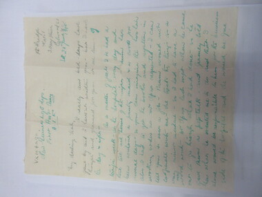
Letter - Letter relating to Service of Lieutenant Colonel H G Bridge Vx104290 written by P.C. Bridge, P.C. Bridge, 23-6-1948
Letter (Handwritten) -
 Wodonga & District Historical Society Inc
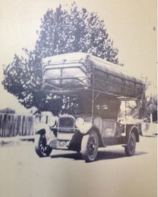
Photograph - John Stanley Cruickshank - The Wodonga Gas Man
This utility truck was one of two used by the Albury Gas Co, from the Gas Works in Kiewa Street, Albury to service the coal gas supply system in Albury during the war years from 1939-1945. The gas bags were installed as petrol was in short supply. One of the trucks was driven by John (Jack) Stanley Cruickshank, also known as Wodonga's Gas Man. Jack became foreman for the Wodonga Branch of the Albury Gas Co. An 80 millimetre galvanised steel pipeline was installed from the Albury Gas Co. in Kiewa Street, Albury, to 26 Church Street, Wodonga. A 40 horsepower pump pushed the gas to holding tanks. Sections of the gas pipeline to Wodonga can still be observed under some of the bridges from Albury to Wodonga. Jack also supervised the laying of the gas pipes in the streets of Wodonga, being hand dug by a gang of 15- 20 men. He was Wodonga's first Gas Fitter, both fitting gas appliances and overseeing their maintenance. Jack Cruickshank passed away in 1979 and is buried at the Wodonga Cemetery.This image is significant because it represents the installation of gas supply to Wodonga, Victoria.A black and white photo of a large van with a gas-filled bag on top of it and also a portrait of Jack Cruickshank. Photos are mounted together with text in a wooden frame.jack cruickshank, wodonga gas supply co. -
 Melbourne Legacy
Postcard, Postcards of Europe
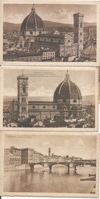
Postcards were a common form of souvenirs for soldiers who were travelling either during World War 1, or just after, or while returning to Australia. These postcard scenes include the Cathedral and a bridge in Florence, and church and the Pantheon in Rome, a view of Lausanne and a fountain in Versailles and an interior from Brussels. These were with other World War 1 memorabilia that has come from Private John Basil McLean, 2nd Reinforcements, 37th Battalion, A.I.F. There was a large collection of postcards so he may have been collecting them as souvenirs. J.B. McLean (Service No. 13824) was from near Maffra, Victoria and enlisted on 22 January 1916. He embarked on 16 December 1916 for Europe. His full war record is available from AWM. He spent time with the Australian Field Artillery (Pack Section). At the end of the war he worked for a year at the A.I.F. Headquarters in London before returning to Australia on the 'Ceramic', arriving Portsea in 1920.Postcards were a very common form of communication in the first World War. Postcards as souvenirs or as correspondence would have been familiar to the first Legatees as they had served in World War 1. Postcards x 12 with images from Rome and Florence in Italy, Lausanne in Switzerland, a fountain in Versailles, France, and an interior in Brussels.01138.1 Firenze - La Cattedrale (the Cathedral in Florence) 01138.2 Firenze - La Cattedrale vista in panorama di sopra ad Or. S. Michele (Alnolfa di Lapo, Brunelleschi ed altri Maestri) 01138.3 Firenze - Ponte S. Trinità 01138.4 Firenze - Piazza delia Signoria, Loggia dei Priori detta dei Lanzi 01138.5 Roma - Il Pantheon 01138.6 Roma - Via Appia Anitca - Tombe. 01138.7 Roma - Via Appia - Aquedotti 01138.8 Capella S. Petri Claver, Romae 01138.9 Lausanne - Ochy 01138.10 Lausanne - Hotel Victoria 01138.11 Parc de Versailles - Bassin des Domes 01138.12 Bruxelles Each one has the word POST CARD on the reverse with room for an address and an area for Correspondence. Different makers.souvenir, world war one -
Port Melbourne Historical & Preservation Society
Book, Public Works Committee, Borough of Sandridge, Municipal Council of Sandridge - Public Works Committee Minutes, 18560 - 1862
Volume of minutes of Public Works Committee of Sandridge Council dated 20.9.1860Title on labellocal government - borough of sandridge, engineering - roads streets lanes and footpaths, engineering - fences, engineering - canals and drainage, engineering - bridges, fishermans bend, built environment - civic, transport - horse, utilities - gas, sandridge lagoon, mission to seafarers, emerald hill, fire and fire services, william morley, joseph weaver allen, thomas swallow, samuel george isaacs, frederick poolman, robert byrne, john murphy -
Port Melbourne Historical & Preservation Society
Book - Borough of Sandridge, Charles Clay, Borough Surveyor, Surveyor's Reports, 1877
Surveyor Charles CLAY's reports to Council March 1877 to June 1882, handwritten. 176pp volume bound in maroon linen with red spine; sticker on front: MINUTE BOOK; 'Surveyor's Reports' hand printedThree names/addresses noted on first page. Two printed Agendas 1881 and 1882 pasted in front.local government - borough of sandridge, engineering - roads streets lanes and footpaths, port melbourne town hall, transport - tramways, engineering - canals and drainage, celebrations fetes and exhibitions, business and traders, fishermans bend, fire and fire services, flood, engineering - bridges, utilities, health - general health, built environment - domestic, industry - manufacturing, livestock, transport - railways, charles clay, sandridge lagoon, business and traders - hotels -
 Port Melbourne Historical & Preservation Society
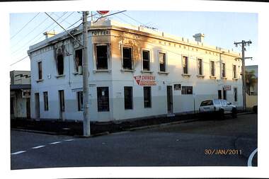
Photograph - Various Port Melbourne locations, Jack Bolt, 2011
Photographed Jan/Feb 2011 by Jack BOLTFrom a series of colour photos taken by Jack Bolt in January/February 2011 .01 - Hibernian Hotel 30.01.2011 after the second fire on 28 November 2010 .02 to .09 - Eight photos of route109 tram tracks being replaced between 29.01.2011 to 2.02.2011 (Graham St stop) .10 - view from upper floor of Woodruff Terrace .11 - air shaft Farrer & Ross Sts. Latter two photos are of work on the Melbourne Main Sewer, Ross and Bridge Streetstransport - tramways, engineering - canals and drainage, fire and fire services, hibernian hotel, jack bolt, business and traders - hotels -
 Port Melbourne Historical & Preservation Society
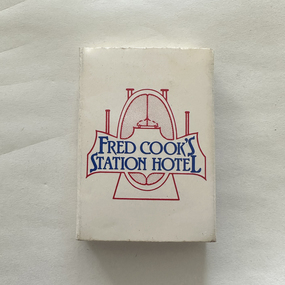
Memorabilia - Matchbox, Fred Cook's Station Hotel, c.1990
The Station Hotel was converted into three townhouses in 1995.The small white matchbox from the Station Hotel situated on the corner of Bridge & Station Streets, Port Melbourne. It was owned by well-known Port Melbourne footballer, Fred Cook from 1982. The background of the front cover logo depicts a stylised football with the four goalposts and 'Fred Cook's Station Hotel' in dark blue. The original Station Hotel was built in 1872 and a second story was added at a later date. The back cover lists the hotel's attractions as Bistro & Piano Bar, A La Carte Menu, Cocktail Bar, Friendly Atmosphere and excellent service as well as the address, 116 Station Street.fred cook, station hotel, built environment - commercial, port melbourne football club, business and traders - hotels -
 Stawell Historical Society Inc
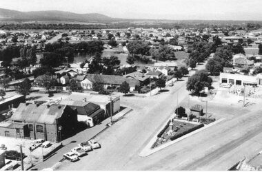
Photograph, Aerial photo of Stawell Lower Main Street looking towards the Grampians 1950's
Aerial shot 1950's, Caltex Service Station, Cato Lake, War Memorial and Weights Bridge, Salvation Army Building and McClure's used Car yard. -
 Eltham District Historical Society Inc
Photograph - Digital Photograph, Marguerite Marshall, Sutherland Home for Children, Diamond Creek, 27 September 2007
The Sutherland Homes for Children on Yan Yean Road, Diamond Creek cared for thousands of children from when it was opened in 1912. The site closed for this purpose in 1991 and was sold and later developed for commercial and office purposes. Covered under Heritage Overlay, Nillumbik Planning Scheme. Published: Nillumbik Now and Then / Marguerite Marshall 2008; photographs Alan King with Marguerite Marshall.; p107 The Sutherland Homes for Children at 14 Yan Yean Road, Diamond Creek, cared for thousands of children since they opened in 1912, after beginning at La Trobe Street, Melbourne in 1908. In 1994 Sutherland Homes (then called Sutherland Child, Youth and Family Services) amalgamated with Berry Street Child and Family Welfare. Together as Berry Street Victoria, they formed Victoria’s largest independent provider of support and accommodation services for children, young people and families in crisis.1 However with the move from institutional to community care, the Diamond Creek site had not been used since 1991 and was sold to private purchasers in 1999. More than 2000 former residents, staff, neighbours and friends attended a farewell in February, 2000.2 The Sutherland Homes red-brick and stuccoed building in Diamond Creek (a rare design in the Eltham Shire), was opened in 1929 by Lord Somers, the Governor of Victoria. Destitute children lived in dormitories bathed in natural light through large windows. However in 1958 as the cottage–parent system replaced the dormitory system, the first of eight residential cottages accommodating ten to 12 children was built. The site also included Special School 3660 and a farm, and the children were able to form relationships with people outside Sutherland, by staying with holiday hosts. Children were originally placed at Sutherland because of extreme poverty, or because single parents could not cope. However later, most placements occurred due to family violence, abuse or neglect. The property was originally bought from the Crown in 1869 by Timothy Mahony. Later owner, Augusta Meglin, ran a 40-acre (16ha) farm there. In 1909 she bequeathed this, including the house, orchards, vegetable gardens, vineyards and the balance of her income to The Sutherland Homes for Neglected Children. Sutherland Homes’ founder, Selina Sutherland, was known as ‘New Zealand’s Florence Nightingale’. In 1888 she became Victoria’s first licensed ‘child rescuer’3 and was to rescue around 3000 waifs from Victoria’s streets and slums.4 Born in Scotland in 1839, Sutherland joined her sister, who had emigrated with her husband to New Zealand. Sutherland trained as a nurse and led the establishment of a public hospital at Masterton. In 1881, while holidaying in Melbourne, Sutherland was so touched by seeing young people living under Princes Bridge, that this determined her future work. Meanwhile Sutherland instigated the Melbourne District Nursing Society, (now Royal District Nursing Service). She also led the founding of The Victorian Neglected Children’s Aid Society (now Oz Child) and the Presbyterian Neglected Children’s Aid Society (now Kildonan). From 1894 Miss Sutherland was Melbourne’s best known woman and cut a distinctive figure, wearing an alpine hat with a prominent feather. In 1906 Prime Minister Alfred Deakin named her Melbourne’s most successful philanthropic worker. However she was to face some difficult times. That year she suffered severely from an injured shoulder and dizzy turns and was pressured to resign as Superintendent of The Victorian Neglected Children’s Aid Society. In 1908 the committee of management offered her 12 months leave with pay. Sutherland declined – but soon after, was dismissed. However she continued her work from Latrobe Street, Melbourne, with the help of Sister Ellen Sanderson and several committee members. Sutherland attempted to register her new organisation but the Victorian Neglected Children’s Aid Society objected to the government, alleging that Sutherland, because of increasing infirmity, was unable to satisfactorily carry out such duties. They accused her of cruelty and of intoxication. However the charges were not proven, so The Sutherland Homes for Neglected Children was registered.5 Sadly, in 1909 Sutherland died, the day she was to move the children to the ‘country property’ at Diamond Creek. At her death she owned less than £10. Today Berry Street recognises Sutherland’s enormous contribution to child welfare with a memorial and an annual Selina Sutherland Award, presented to an outstanding volunteer.This collection of almost 130 photos about places and people within the Shire of Nillumbik, an urban and rural municipality in Melbourne's north, contributes to an understanding of the history of the Shire. Published in 2008 immediately prior to the Black Saturday bushfires of February 7, 2009, it documents sites that were impacted, and in some cases destroyed by the fires. It includes photographs taken especially for the publication, creating a unique time capsule representing the Shire in the early 21st century. It remains the most recent comprehenesive publication devoted to the Shire's history connecting local residents to the past. nillumbik now and then (marshall-king) collection, diamond creek, sutherland home for children -
 Melbourne Tram Museum
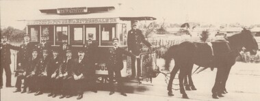
Photograph - Sepia-toned - Hawthorn horse tram
Photo shows one of the horse trams and staff that operated the line that ran from Hawthorn Bridge via Burwood Road, Power Street, and Riversdale Road to Auburn Road, opening in 1890. There are 9 uniformed men and three officers in the photograph. The tramway operated until 1916 when it was replaced by an electric tram. See item 7446 for a black and white print with more detail in the background. Yields information about the crews that worked the Hawthorn Bridge to Auburn Road horse tram service.Photo part of a sepia-toned postcard showing a Hawthorn horse tram.Has a "Club 89" image on the rear which was the image used for the 1989 Australia Post stamp show and in handwriting on rear "Horse Drawn tram - 1889 to 1916"trams, tramways, horse trams, crews, australia post, stamp show -
 Melbourne Tram Museum
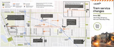
Pamphlet, Public Transport Victoria (PTV), Tram Service Changes, 2022
Pamphlet provided at tram stops giving details of the works and bus services for: .1 - route 72 track reconstruction between Chapel St and Orrong Road, in Malvern Road including the Orrong Road over rail line bridge - 29-4-2022 to 14-5-2022 .2 - All Collins and William St routes for the installation of a super stop in William St at Collins St - - 2-2-2022 to 6-2-2022Shows the methods that Yarra Trams and Public Transport Victoria customers are advised of changes due to track replacement works..1 - Pamphlet - DL, five fold DL - Tram service changes - route 72 - 29-4-2022 to 14-5-2022 .2 - Pamphlet - DL, four fold DL - changes in Collins and William Streets - 2-2-2022 to 6-2-2022tram works, track work, yarra trams, ptv, bridges, trams, tramways, route 72, malvern road, orrong road, super stops, collins st, william st -
 Melbourne Tram Museum
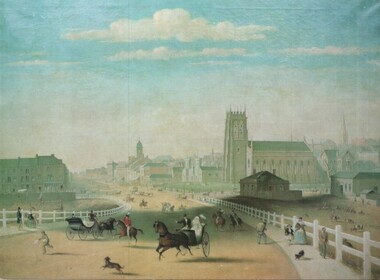
Artwork, other - Swanston Street from Princes Bridge c1861
Colour print of Reproduction of an oil painting - Swanston Street from Princes Bridge c1861 showing Johnson's Bridge Hotel, later Young and Jacksons, the first St Paul's church building, original Town Hall building and the tower of Scots church. Shows pedestrians and horse drawn carriages before the introduction of public omnibus services in 1869. Not known who produced the card.Yields information about early Melbourne after the start of the gold rush.Reproduction of an oil painting - Swanston Street from Princes Bridge c1861 by Henry BurnIn ink on the rear Keith Kings stamp and the initials RG and "Melbourne"melbourne, princes bridge, horse drawn vehicles, st pauls cathedral, hotels -
 Melbourne Tram Museum
slide - Colour - Melbourne trams - Collins St, David Verrier, 7-11-2002
1 - C1 3032 at Collins and King St. Note the Collins St over bridge and the tram stops at King St intersection. 2 - City Circle car 925 at corner of Spencer and Collins Sts 3 - C1 3024 westbound at corner of King and Collins St. 4 - W7 1021 (Route 12) in Collins StYields information about Collins Street services and the City Circle tram.Set of four colour Sides - white Kodak KodachromeSlide marked with date and details.tramways, trams, tram 3032, king street, spencer street, c1 class, tram 3024, tram 1021, route 12, tram 925, city circle, collins st -
 Melbourne Tram Museum
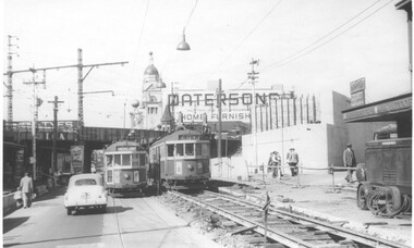
Photograph - Black and White - Swan Street track lowering, John Alfred, 1957
Photo shows - works in Swan Street Richmond to lower the tram tracks under the Railway bridge which were later replaced by an open web girder truss bridge. The track on the left has been completed while on the right, the original road surface can be seen as well as the temporary track. Shows the abutment for a new railway bridge on the right, for the six tracks to South Yarra. Tram W2 330 (left, Camberwell Depot, route 76) and 339 (City, route 77) are passing each other. In the background is a large advertisement for Pattersons home furnishings. Photo dated 1957.Yields information about alterations to tram services during road reconstruction project.Photograph - Black and White - Swan Street track lowering Has details handwritten on rear, date stamp and John Alfred Stamp. tramways, tramcars, swan street, richmond, route 77, railways, bridges, tram 330, tram 339 -
 Ballarat Tramway Museum
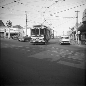
Photograph - Set of four black and white negatives of Ballarat trams, Warren Doubleday, 20-4-1968
Photos 25-4-69, of: .1 - Ballarat 17 at Stones Corner with Caltex Service Station in the background. Tram leaving Main Road before joining Bridge St. .2 - No. 28 running from Bridge Street into Sturt Street with a "Trotting at Bray Raceway Tonight" Auxillary board. Tram has the destination of Gardens via Sturt St West. In the background are the Big W and the Dickins Store. .3 - Tram 43 on "0" road at the SEC Ballarat Depot. .4 - Tram 13 at the Gardens Loop in Wendouree Parade. Tram has an ANA Hospital and Medical Benefits (Australian Natives Association) Advertising Board.Yields information about the operation of the Ballarat tramway system that was operated by the State Electricity Commission of Victoria.Set of four black and white negatives of Ballarat Tramways, 120 size. ballarat, trams, tramways, sturt street, tram 17, main road, bridge street, tram 28, bray raceway, dickins, big w, tram 13, ana health, wendouree parade, gardens loop, depot, tram 43, stones corner, caltex