Showing 19371 items matching "shipwreck-coast"
-
 Lakes Entrance Historical Society
Book, M Holding, Fishing Industry Wrecks and Drownings
A folder of some information on fishing industry boats shipwrecks and deaths associated with the work place Lakes Entrance Victoriaboats and boating, ships and shipping, shipwrecks -
 Flagstaff Hill Maritime Museum and Village
Document - Navigation Chart, Admiralty Office, Lady Bay and Warrnambool Harbour, 03/04/1871
This Chart titled “Lady Bay and Warrnambool Harbour” was surveyed by Nav. Lieut. H.J. Stanley, of Britain's Royal Navy, in 1870 and printed in April 1871. The chart was made before the Warrnambool Breakwater was built (construction had begun in 1874 and was completed in 1890). The chart includes Directions for entering Lady Bay, Warrnambool Harbour. These are "Vessels entering Warrnambool Harbour must bring the Red Light in sight and steer in with it in line with the upper white Light bearing North, until the Green Light on the Jetty is opened, when steer towards it and anchor. The best anchorage is in 2 ¼ fms [fathoms)] of water, about a cable from ledge off Breakwater rock. Or where convenient, according to draught of water, only endeavouring to anchor as close as possible to Breakwater rock. It is not safe to enter or leave the Harbour in south westerly or Southerly gales.” This chart is significant for its strong connection to the maritime history of Warrnambool Harbour and Lady Bay, and eventually to the Warrnambool Breakwater. The Warrnambool Breakwater is registered as a place of significance on the Victorian Heritage Database (VHR H2024). A copy of the same chart was used to plan several submissions for future changes to the jetty and breakwater. The chart is a historical record of structures existing in 1870; the Warrnambool Jetties, Lady Bay, the leading lights (lighthouses), streets, roads, bridges and many buildings. It also shows the lay of the land and seabed.Canvas chart of Australia, South Coast, Victoria Title: Lady Bay and Warrnambool Harbour Surveyed by Nav. Lieut. H.J. Stanley, R.N., 1870. Magnet Variation, 1870 Published April 3, 1871, by the Admiralty, London. Directions for vessels entering Warrnambool Harbour are printed on the chart. The chart has a lacquer or seal over it.Top of chart has logo "HYDROGRAPHER OFFICE" "Price Eighteen Pence". "Engraved by Edward Weller" Along bottom of Chart: “London… Published at the Admiralty, 3rd April 1871, under the Superintendence of Rear Admiral G.H. Richards, F.R.S. Hydrographer, Corrections July 71” Bottom of chart “Australia South Coast Victoria Lady Bay and Warrnambool Harbour. 2494”flagstaff hill, warrnambool, chart of lady bay warrnambool 1870, warrnambool harbour, cartography, navigation, warrnambool breakwater, 1871, australia – south coast / victoria, lady bay, 1870, nav. lieut. h.j. stanley, r.n, directions for entering warrnambool harbour, hydrographer office, rear admiral g.h. richards, edward weller, port of warrnambool, flagstaff hill maritime museum & village, maritime museum, maritime village, shipwreck coast, map, chart, navigation chart, admiralty chart, breakwater, jetty, pier, vhr h2024 -
 Flagstaff Hill Maritime Museum and Village
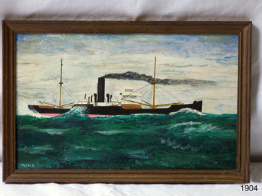
Painting - Vessel, Steamship, Mike McCrea (artist), ca 1985
... shipwreck-coast ...This is one of a pair of paintings by artist Mike McCrea, created when he was in Warrnambool in 1985. The painting was framed and sold by Patana Galleries, Paton Place, Manly Vale, NSW. It was later purchased by athe company of Master Mariners of Australia and who donated the pair to Flagstaff Hill. The pair of paintings are significant for their association with steamships and the Master Mariners of Australia group. The paintings represent a time in local history when many steamships were sailing the coast and transporting passengers and goods.Painting; timber framed oil painting with the image of a cargo steamship off the coast of Warrnambool. Artist is Mike McCrea. Framed by Patana Galleries, Manly Vale, NSW. Hand written, "Red. No. 390 A" Sticker "61"flagstaff hill, warrnambool, shipwrecked-coast, flagstaff-hill, flagstaff-hill-maritime-museum, maritime-museum, shipwreck-coast, flagstaff-hill-maritime-village, painting, mic mccrea, patana galleries, master mariners of australia, steamship -
 Flagstaff Hill Maritime Museum and Village
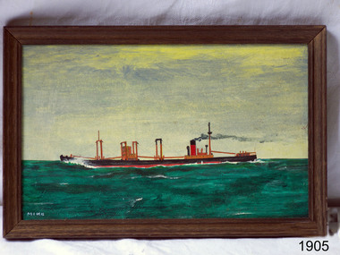
Painting - Vessel, Steamship, Mike McCrea (artist), ca 1985
... shipwreck-coast ...This is one of a pair of paintings by artist Mike McCrea, created when he was in Warrnambool in 1985. The painting was framed and sold by Patana Galleries, Paton Place, Manly Vale, NSW. It was later purchased by athe company of Master Mariners of Australia and who donated the pair to Flagstaff Hill. The pair of paintings are significant for their association with steamships and the Master Mariners of Australia group. The paintings represent a time in local history when many steamships were sailing the coast and transporting passengers and goods.Painting, framed oil on board; cargo steamship off the coast of Warrnambool by artist Mike McCrea. Framed by Patana Galleries, Manly Vale, N.S.W. Signed by artist.Signed; "MIKE" "J15/62 McCrea" "Red. No. 390 A" Sticker with "62" "PATANA GALLERIES / PATON PLACE, MANLY VALE / PHONE 949-1535"flagstaff hill, warrnambool, shipwrecked-coast, flagstaff-hill, flagstaff-hill-maritime-museum, maritime-museum, shipwreck-coast, flagstaff-hill-maritime-village, painting, mike mccrea, steamship, master mariners of australia, patana galleries -
Glenelg Shire Council Cultural Collection
Letter - Letter - Invitation 'Shipwrecks' Part of Admella 150 Festival, Aug-09
Invitation, black print on bluecard, from Portland Bay Press, exhibition titled 'Shipwrecks' Part of Admella 150 Festival. -
Lakes Entrance Historical Society
Book, Holding M, Shipwrecks, 2010
Information on shipwrecks drownings and shipping adjacent to the entrance to the lakes also various other unrelated information gipplsand Lakes Victoriashipwrecks, fishing industry -
Glenelg Shire Council Cultural Collection
Poster - Poster - Admella 150 Festival, c. 2009
Laminaterd A3 poster promoting Admella 150 festival events in the limestone coast and Discovery coast regions. Posters shades of blue with black and white printing. Admella 150 logo top left corner. Gold sponsors logo's top right. -
 Flagstaff Hill Maritime Museum and Village
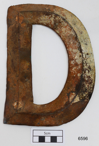
Plaque - Nameplate, Circa 1886
The brass letter “D” is from the starboard bow of the FALLS OF HALLADALE, a 2085 ton iron-hulled and four-masted sailing ship that was wrecked near Peterborough on 14 November 1908. Two companion pieces, the letters “S” and “A”, are also in the Flagstaff Hill Maritime Village collection of shipwreck artefacts (as registered numbers 748 and 6595). The ship’s name originally appeared in these impressively large brass letters across the stern and both port and starboard bows of the vessel. The FALLS OF HALLADALE was built in 1886 by Russell & Co at their Greenock shipyards on the River Clyde. She was the seventh of nine similar cargo carriers produced for the owners of the Falls Line, Wright, Breakenridge & Co of Glasgow. All nine ships were named after waterfalls in Scotland. First was the FALLS OF CLYDE in 1878, then the FALLS OF BRUAR in 1879 (lost in 1887), the FALLS OF DEE in 1882 (sunk in 1917), the FALLS OF AFTON in 1882, the FALLS OF FOYERS in 1883 (disappeared in 1898), the FALLS OF EARN in 1884 (wrecked in 1892), the FALLS OF HALLADALE in 1886 (wrecked in 1908), the FALLS OF GARRY in 1886 (wrecked in 1911), and the last of the fleet, the FALLS OF ETTRICK (lost in 1906). The FALLS OF CLYDE is still afloat as an exhibit at the Hawaii Maritime Center in Honolulu. Russell & Co delivered the owners full-bottomed, economical ships of 1800 to 2000 tons, practically designed to minimise loss of speed while increasing seaworthiness and carrying capacity. The sturdily constructed FALLS OF HALLADALE had iron masts and wire rigging, allowing her to maintain full sail even in gale conditions, and square “warehouse-type” bilges to accommodate maximum bulk cargo on her long-haul voyages. This class of ship remained commercially competitive into the twentieth century despite the advantages of coal-fired steamships. When the 22 years old FALLS OF HALLADALE finally foundered on Victoria’s Shipwreck Coast in 1908, the Melbourne Court of Marine Inquiry found it was entirely due to Captain D.W. Thomson’s navigational error, rather than any technical failure of the Clyde-built ship. The shipwreck of the FALLS OF HALLADALE is of state significance — Victorian Heritage Register No. S255. The Falls of Halladale shipwreck is listed on the Victorian Heritage Register (No. S255). She was one of the last ships to sail the Trade Routes. She is one of the first vessels to have fore and aft lifting bridges. She is an example of the remains of an International Cargo Ship and also represents aspects of Victoria’s shipping industry. The wreck is protected as a Historic Shipwreck under the Commonwealth Historic Shipwrecks Act (1976).Large brass letter “D”, from the shipwreck FALLS OF HALLADALE, dented but in generally good unrestored condition. Front face of dull grey-green metal showing reddish oxide stain and some cream-coloured concretisation. Rear face has not been brushed clean and displays more encrustation.The four bolt collars for fixing letter to ship are filled with sediment.warrnambool, shipwreck coast, flagstaff hill, shipwrecked coast, flagstaff hill maritime village, flagstaff hill maritime museum, shipwreck artefact, maritime museum, great ocean road, brass lettering, falls of halladale, 1908 shipwreck, russell & co., ship nameplate, nameplate, letter, letter d -
 Phillip Island and District Historical Society Inc.
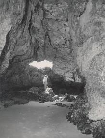
Photograph, Bryant West
One of a collection of over 400 photographs in an album commenced in 1960 and presented to the Phillip Island & Westernport Historical Society by the Shire of Phillip IslandPhotograph inside Forrest Caves South Coast Phillip Island. Man inside looking out. local history, photography, photographs, coastline, caves, phillip island, forrest caves phillip island, john jenner, bryant west -
Glenelg Shire Council Cultural Collection
Souvenir - Keyring - Portland Coast Region Water Authority, n.d
Key ring - Portland Coast Region Water Authority, gold coloured metal, enamelled designsouvenir, advertising -
Glenelg Shire Council Cultural Collection
Accessory - Badge - Bridgewater Sports, n.d
Metal badge, Bridgewater Sports New Year's Day with image of Cape Bridgewater and coast; roundcelebration, new years day, badge, cape bridgewater -
 Bendigo Historical Society Inc.
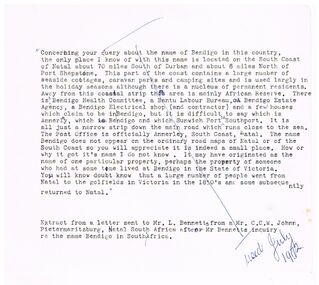
Document - BENDIGO - NATAL, 07/1972
Typed notes about a query about the name of Bendigo on the South Coast of Natal, South Africa.document, bendigo - natal, mr l bennetts, mr c c w johnn -
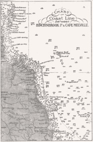 Queenscliffe Maritime Museum
Map - B & W coastal map of Hinchinbrook Island to Cape Melville in Queensland, Coastal map Queensland Hinchinbrook Is to Cape Melville, Before donation in 1987
Australian coastal mapsAustralian coastal mapsMap from unknown book of Queensland coast Hinchinbrook Island to Cape Melville, pre 1987Reverse " NIL "old maps of australian coast -
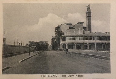 Kew Historical Society Inc
Postcard, The Cairo Postcard Trust, Port-Said - The Lighthouse, c.1918
One of a number of 'real photo' and commercial postcards created by or owned by members of the Christian and Washfold families of Kew. The postcards are part of a larger collection of photographs, postcards and publications donated to the collection in May 2021.Sepia postcard of Lighthouse at Port Said, located on the north east coast of Egypt on the Mediterranean Sea.The Cairo Postcard Trust Cairo 957 / Serle 632washfold family, postcards -- port said, christian family, christian-washfold collection -
Lakes Entrance Historical Society
Booklet, Ronald Parsons, Australian Coastal Passenger Ships, 1981
The details and a brief outline of the career of every steam and motor ship that carried passengers on the Australian coast.ships and shipping -
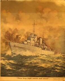 Ringwood RSL Sub-Branch
Printed Display item, Circa WW2
Coloured print of the HMAS Sydney which was lost with all hands of the Western Australian Coast in WW2"They keep high watch and ward" The HMAS Sydney in action by John Allcot. -
Tatura Irrigation & Wartime Camps Museum
Photograph, 2001
Jack Sharpley lived in Erica Av. Tatura. His father was a P.M.G. Linesman c.1939. Jack attended Tatura Convent & Shepparton High School. Joined staff of State Savings Bank, and attended Melbourne University. Entered Air Force in Air Training Corps 1941. Trained in Canada as a Flight Observer. Posted to a Sunderland Flying Boat Squadron in England. Killed 04.02.1943 in a flying accident off the coast of Wales. A brillian pupil and an outstanding athlete.Photograph of Jack Sharpley who lived in Erica Av. Tatura. His father was on the P.M.G. line staff at Tatura c.1939-41. Jack entered the RAAF through the Air Training Corps. Trained in Canada, flew in Sunderland Flying Boats. Died in crash on duty off the coast of Wales.sharpley, jack, raaf, photograph, people -
 Flagstaff Hill Maritime Museum and Village
Lithograph
... shipwreck-coast ...Lithographs of various types pertaining to Suez Canal, shipwrecks and marine art of the 1800s. Also included in this collection are lithographs connected with cable laying done during this particular period. These woodcut lithographs appeared in "The Illustrated London News"flagstaff hill, warrnambool, shipwrecked-coast, flagstaff-hill, flagstaff-hill-maritime-museum, maritime-museum, shipwreck-coast, flagstaff-hill-maritime-village, lithographs, woodcut lithographs, illustrated london news, 19th century lithographic art -
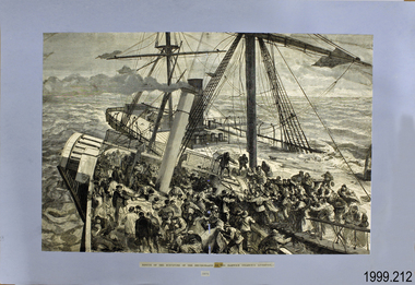
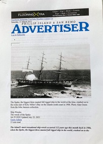 Phillip Island and District Historical Society Inc.
Article, The wreck of the Speke - The Advertiser July 2021
The Speke was wrecked in Kitty Miller Bay, Phillip Island in 1906. This account by Donald Cameron was later challenged by local historians.HistoricalA4 printed copy of an article from The Advertiser on shipwrecks and The Speke. It contains recollections of local, Donald Cameron. July 25, 2021The Advertiser. Ship Wrecks. The Wreck of the Speke. Jul 29 2020 Updated July 25, 2021the speke, shipwrecks, the advertiser, sailing ships, donald cameron, kitty miller bay phillip island, figurehead of the "speke" -
Glenelg Shire Council Cultural Collection
Souvenir - Keyring - Portland, n.d
Key ring, rubber 'Portland Birth Place of Victoria'. Raised montage of lighthouse, cable tram, southern right whale, shipwrecks.tourism, souvenir of portland -
Queenscliffe Maritime Museum
Geological specimen - Copper ore
The Empress of the Sea was a magnificent three masted, square rigged, wooden sailing clipper ship built in Boston, USA. The Empress of the Sea is historically and archaeologically significant as it was one of Donald Mackay's famous wooden clipper ships, i.e. representative of a particular design or type. It was also associated with both the Black Ball and White Star Lines of Australian Packets, which carried thousands of immigrants from Britain to Australia. The Empress of the Sea caught fire at Queenscliff at 4 am on 19 December 1861. When the officer of the watch attempted to extinguish the fire they found fire pump handles missing and buckets ineffective. Fire became out of control and the ship was sailed from anchorage and ran ashore at Point Nepean. Ship rolled over onto starboard side by force of the tide and the shifting ballast. The port side was burnt to the copper. The Empress of the Sea lies in 5 metres (16 feet) to 7 metres (23 feet) of water, 700 metres (2,297 feet) offshore from Nepean Bay, Port Phillip. The site covers an area 150 metres (492 feet) long and 50 metres (164 feet) wide. The bow lies towards the south-west. Piece of copper ore, possibly part of ships cargo, recovered from the site of the Empress of the Sea shipwrecked in Nepean Bay 1861shipwrecks, nepean bay, empress of the sea -
Lakes Entrance Historical Society
Book, Love Don, Shipwrecks around Port Phillip Heads, 2007
Well documented stories of the shipwrecks around Port Phillip Heads Victoria 1840-1900 with references photographs location Map and sketches.ships and shipping, history -
 Phillip Island and District Historical Society Inc.
Photograph - Post Card, 1920's
One of a collection of photographs donated by Steve Stefan, Archivist, St Frances Church, MelbourneBlack & White postcard showing the rugged coastline at San Remo."The Rose Series, P. 710" "The picturesque coast, San Remo, Victoria"san remo coastline, coastline, steve stefan -
Glenelg Shire Council Cultural Collection
Photograph - Photograph - Tohoku Paper Co., Ltd., Akita Mill, n.d
Glenelg Shire Council RecordsAerial view of a factory on the coast. Jetties and piers in background. Framed in aluminium frame with thin plastic glazing.Front: Tohoku Paper Co., Ltd, Akita Millpaper and pulp industries, japan, maritime industry -
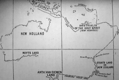 Ballarat Heritage Services
Photograph - Map, A Sketch from Dalyrmples Map of 1767, 1767
Copy of a map showing the coast that was known during the voyge of the Endeavour, and the first map that marks Torres track.map, new holland, hollandia nova, isaac de graaff, new guinea, australia of the holy spirit, papua, new hebrides, new zealand, nuyts land, van dieman's land, tasman's track, torres -
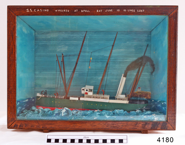 Flagstaff Hill Maritime Museum and Village
Craft - Ship Model, S.S. Casino
Ship model of coastal trader SS Casino in glass fronted case with stained wood frame. Ship has both steam and sail. Background of lighthouse on cliff, sea and sky. Ship painted green, 3 flags flying. Details (incorrect) of ship painted in white across top frame of case. The S.S. Casino was a passenger and freight steamer built in Dundee, Scotland, in 1882 for the Newcastle and Hunter River Steam Navigation Company of N.S.W. She weighed 425 tons gross with a length of 160.4 feet, beam of 24.1 feet and depth of 10.2 feet. She had saloon accommodation for 35 people, forecabin for 25 more people, and she carried 300 tons of cargo. While on her delivery journey on May 30th 1882 the S.S. Casino called in at the Port of Warrnambool for coal ., narrowly escaping going ashore in gale force winds due to the quick action of the pilot. At that time, still at anchor, she impressed the directors of the Belfast and Koroit Steam Navigation Company so much that they bought her immediately; she was ideal for trade in along the West Coast of Victoria. (Belfast is the original name for Port Fairy, South West Victoria. The Belfast and Koroit Steam Navigation Company was first managed by Messers. Saltau and Osburne and after the passing of Mr. Osburne, by produce merchants Messers H. Sautau and Sons, whose had a hay and corn store and shipping agency was on the corner of Liebig and Koroit Streets in Warrnambool. ) The S.S. Casino became “the most famous steamer to operate in Victorian waters along the West Coast” by author Jack Loney. Captain Boyd was her first Master, followed by Captain Chapman, who stayed with her 1890 until 1924. Captain W. Robertson followed for a short term, then Captain Middleton then took command 1925 - 1932. The S.S. Casino had several mishaps during her life. One was on 3rd January 1898 when she collided with the S.S. Flinders in Apollo Bay with minor damage. Another was on 24th October 1924 when she grounded on a reef at Point Hawdon near Grey River and most of her cargo (of Christmas goods) had to be dumped into the sea. Then in February 1929 she was ‘holed’ when she struck a submerged object as she entered Lady Bay, Warrnambool. On the morning of 10th July 1932, after attempting to berth at Apollo Bay jetty in heavy seas, Captain Middleton decided to take her out into the bay and wait until the seas abated. It was not realised that the anchor used to steady her as she manoeuvred to her berth had pierced her hull. She put about and headed for the beach but sank. Captain Middleton and nine others lost their lives; nine people were rescued including the two female passengers . Captain Middleton had been in charge of the S.S. Casino for seven years. He was the first ship’s Master to lose his life through shipwreck in the West Coast trade. In the years following the turn of the century the S.S. Casino remained the only regular trader with normal passenger accommodation along the West Coast. From 1882 she had made at least 2,500 voyages on the one run. Flagstaff Hill’s collection has a photograph of a portrait of Captain Chapman, , a ship model of the S.S. Casino that shows both forms of power under which she sailed, steam and sail. The ship is painted green and flies three flags. The inscription across the case of the ship model, incorrectly dated, tells the sad story of the wreck of the ship and the loss of lives on July 10th 1932 at Apollo Bay. A print in the Collection show S.S. Casino underway in heavy sea off Point Lonsdale, another two photographs show her at the Port of Warrnambool, leaving from the Breakwater in Lady Bay and another identifies the S.S. Casino as a ship from the Belfast and Koroit Steam Navigation Company. (Belfast is the original name for the township of Port Fairy). This ship model is significant because of its association with the coastal trader S.S. Casino 1882-1932 and its significance to trade along Victoria's West Coast in the late 19th and early 20th century. The wreck of the S.S. Casino is considered an important part of Victorian and Australian cultural heritage and as such has been declared and protected as an Historic Shipwreck under State and Commonwealth Law in the Commonwealth Historic Shipwrecks Act (1976). Ship model SS Casino in glass fronted case with stained wood frame. Ship has both steam and sail. Background of lighthouse on cliff, sea and sky. Ship painted green, 3 flags flying. Details of ship painted in white across top frame of case. NOTE: Correct details for shipwreck is 10 July 1932, at Apollo BayPainted in white on wood across top of case "SS CASINO WRECKED AT APOLL BAY JUNE 10 10 LIVES LOST".flagstaff hill, warrnambool, shipwrecked coast, flagstaff hill maritime museum, maritime museum, shipwreck coast, flagstaff hill maritime village, great ocean road, newcastle and hunter river steam navigation company, belfast and koroit steam navigation company, h. sautau and sons, s.s. casino, west coast trader s.s. casino, victorian coastal trader, captain boyd, captain w. robertson, captain chapman, captain middleton, apollo bay shipwreck, s.s. casino at lady bay warrnambool, ship model s.s. casino, saltau and osburne -
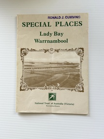 Warrnambool and District Historical Society Inc.
Pamphlet - Special Places Lady Bay Warrnambool, Philprint Warrnambool, 1989
This pamphlet was produced for the Warrnambool Branch of the National Trust of Australia (Victoria) for Heritage Week, April 16-23, 1989 and contains information written by Warrnambool residents about their locality. This was a co-operative venture by people with a common interest in protecting the natural environment near their home. Areas covered in the written information include: Formation of the Coast, Archaeological survey, Gunditjmara History, vegetation, history and recreational uses of the Lady Bay area. The map shows special places of interest including past and present navigational aids, sites of shipwrecks and other historical places of interest. The Warrnambool Branch of the National Trust was originally formed in March 1969 and merged with the Port Fairy Branch in late 1970. In October 1979, the Warrnambool Branch was reformed and operated into the late 1990's. This is an example of a publication produced by the Warrnambool Branch of the National Trust Australia (Victoria). It provides historical information and perspectives of the recreational uses in and around Lady Bay Warrnambool.An A2 piece of buff coloured thick paper folded into eight to make an A5 pamphlet. The front cover has green printing with the National Trust symbol of three eucalyptus leaves in green. There is a brown sepia photograph showing a view across Lady Bay with the suspension bridge across the Merri River in the foreground, Viaduct Road in the middle ground and the breakwater in the background. There is a purple inked stamp on the top right hand corner. The rear cover has brown writing and includes logos of bodies who assisted with the publication. There is a brown line drawing of the viaduct and pier at the Warrnambool Breakwater. The inside of the unfolded pamphlet contains a map of Lady Bay and adjacent area showing places of interest and shipwrecks marked in red circlesFront cover: Special Places Lady Bay Warrnambool National Trust of Australia (Victoria) Warrnambool Branch Ronald J. Cummingwarrnambool, lady bay warrnambool, national trust australia victoria warrnambool branch, heritage week 1989, lady bay shipwrecks -
 Phillip Island and District Historical Society Inc.
Photograph, Bryant West
One of a collection of over 400 photographs in an album commenced in 1960 and presented to the Phillip Island & Westernport Historical Society by the Shire of Phillip IslandPhotograph of a Map of Phillip Island. The first to show Fort Dumaresq, track to beach and beginning of road to South coast. local history, photography, photographs, exploration, maritime, documents, maps, phillip island, john jenner, bryant west -
 Lakes Entrance Historical Society
Photograph, 1975
Also three same size similar photographsColour photograph of the Hippolite Rocks on the south east coast of Tasmania, taken from the fishing boat Minawie. Tasmaniafishing industry, boats and boating, topography, ocean -
Lakes Entrance Historical Society
Book, Gardner P D, Names of Bass Strait, 1996
Some of the place names of the Bass Strait coasts, and Bass Strait Islands, and explanations of their meanings. Illustrated with maps and photographs.township, social history, topography