Showing 8618 items matching "south road"
-
 City of Moorabbin Historical Society (Operating the Box Cottage Museum)
Newsletter, City of Moorabbin Historical Society Feb 2009, February 2009
... south road brighton... 1851 point nepean road south road brighton thomas street ...The City of Moorabbin Historical Society was formed c 1960 by a group of Moorabbin residents who were concerned that the history of the area should be preserved. A good response to a call for items related to the historical area of Moorabbin Shire brought donations of a wide variety of artefacts which are now preserved by the current members of CMHS at Box Cottage Museum . Helen Stanley, Secretary of CMHS, began producing a Newsletter for members in April 2007 to provide current information and well researched items of historical interest.Helen Stanley has produced a bi-monthly Newsletter, 2007 - 2013, for the members of the City of Moorabbin Historical Society that contains well researched interesting historical items, notification of upcoming events, current advice from Royal Australian Historical Society , Museums Australia Victoria and activities of Local Historical Societies. The Newsletter is an important record of the activities of the CMHS. Tom Sheehy, past President of CMHS, was an Historian and Author of ‘Battlers Tamed the Sandbelt’. 2 x A4 paper printed on 3 sides Issue 10 of the bi-monthly, City of Moorabbin Historical Society Newsletter produced by Society member and Secretary, Mrs Helen Stanley in February 2009. The Victorian Bushfire tragedy around Marysville is still unfolding as this Newsletter is written. The first meeting for the year is February 22nd and subscriptions are due. An excerpt is transcribed from the City of Moorabbin Historical Society Newsletter October 1962, “A Piece of History in Ormond” by an unknown eyewitness author, describing the original “Box Cottage” situated in Mr J. Reitman’s cement products factory at 306 Jasper Road, Ormond prior to demolition. The current Editor gives information obtained from further recent research . An Article by Tom Sheehy, past President and Historian, February 1979 “The Vineyards of Moorabbin”. The ‘Brighton Estate” began when Henry Moor brought Vine cuttings from Camden NSW 1848 and they were productive after 3 years. Many Vineyards then appeared from Port Phillip Bay to East Boundary Road and produced 2/3 of the annual Victorian grape crop. Disease or insect caused failure in1858 and the land reverted to market gardens. A coloured photocopied photo of Box Cottage 2005. CITY of MOORABBIN HISTORICAL SOCIETY / FEBRUARY 2009 NEWSLETTERcity of moorabbin historical society, stanley helen, sheehy tom, melbourne, moorabbin, brighton, cheltenham, ormond, bentleigh, vineyards, fruit growing, vine diseases, winemaking, grapes, market gardeners, pioneers, early settlers, moorabbin shire, box cottage museum, dairy, port phillip bay, brighton estate, moor henry, cambden estate, reitman j., reitman w., cement, pottery, jasper road ormond, east boundary road brighton, dendy’s special survey 1851, point nepean road, south road brighton, thomas street brighton, north road brighton, county of bourke, box h., box william, bruton william, brighton brewery, parish of moorabbin, parish of prahran, markets, shingle roof, weather-board, downward mr., mckinnon -
 City of Moorabbin Historical Society (Operating the Box Cottage Museum)
Newsletter, City of Moorabbin Historical Society Apr 2009, April 2009
... south road brighton... brighton dendy’s special survey 1851 point nepean road south road ...The City of Moorabbin Historical Society was formed c 1960 by a group of Moorabbin residents who were concerned that the history of the area should be preserved. A good response to a call for items related to the historical area of Moorabbin Shire brought donations of a wide variety of artefacts which are now preserved by the current members of CMHS at Box Cottage Museum . Helen Stanley, Secretary of CMHS, began producing a Newsletter for members in April 2007 to provide current information and well researched items of historical interest.Helen Stanley has produced a bi-monthly Newsletter, 2007 - 2013, for the members of the City of Moorabbin Historical Society that contains well researched interesting historical items, notification of upcoming events, current advice from Royal Australian Historical Society , Museums Australia Victoria and activities of Local Historical Societies. The Newsletter is an important record of the activities of the CMHS.2 x A4 paper printed on 4 sides Issue 11 of the bi-monthly, City of Moorabbin Historical Society Newsletter produced by Society member and Secretary, Mrs Helen Stanley in April 2009. Notice that Mr Travis Sellars, Friends of Cheltenham and Regional Cemeteries, will talk about ‘The Tragic 20’s’ at the meeting April 26th . Volunteers are needed to show visitors around on Open Days each month and a Roster will be made on April 26th . Suggestions are requested for the Community Grant Application to be submitted by CMHS. Historical details are condensed from ‘ The Living Harvest’ by W.T Dobson, describing the establishment of St. Peter’s Catholic School East Bentleigh 1865 on land donated by Fred Quinn , in Centre Road, East Brighton ( East Bentleigh). A photo copy of Parts of Country Portion 39 of Dendy’s Special Survey or Brighton Estate showing the Land Sales of Lot 2, & 3 North Road and Jasper Road 1841 – 1869. Interesting note on the origin of ‘Jasper Road’. 3 photocopied photographs of St Peter’s School building 1903, School Children at East Brighton Railway Station, 1903, A Lorry in the parade 1903. CITY of MOORABBIN HISTORICAL SOCIETY / APRIL 2009 NEWSLETTERcity of moorabbin historical society, stanley helen, dobson w.t., melbourne, moorabbin, brighton, friends of cheltenham and reional cemeteries, cheltenham, ormond, bentleigh, market gardeners, irish immigrants c1850pioneers, early settlers, moorabbin shire, box cottage museum, port phillip bay, brighton estate, jasper road ormond, east boundary road brighton, dendy’s special survey 1851, point nepean road, south road brighton, thomas street brighton, north road brighton, county of bourke, box h., box william, parish of moorabbin, parish of prahran, markets, shingle roof, weather-board, mr., mckinnon, were jonathan, niall rev. fr. patrick, quinn fred, elsternwick, catholic church directory 1878, hibernian society melbourne, brady peter., kennedy mr., boland mr., leary mr., gahan mr., archbishop carr, rev. fr. gough., presentation convent gardenvale, sister mary vincent, charlston john, bavarian dress band, hales jasper -
 City of Moorabbin Historical Society (Operating the Box Cottage Museum)
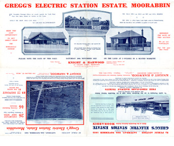
Flyer - Gregg's Electric Station Estate, Moorabbin, 1925
... South Road... of the progress of the Municipality of Moorabbin South Road Barry Street ...The train line from the city to Frankston was electrified which intensified the sale in the municipality of Moorabbin, particularly land which was in the vicinity of the railway stations.Example of the progress of the Municipality of MoorabbinAdvertising flyer for auction of real estate sales - plan of building blocks for saleGregg's Electric Station Estate, Moorabbin 26 business site and 46 home sites - Knight & Harwood pictures of local sites and buildingssouth road, barry street, south avenue, plym street, moorabbin, moorabbin station, gregg, real estate, auction -
 City of Moorabbin Historical Society (Operating the Box Cottage Museum)
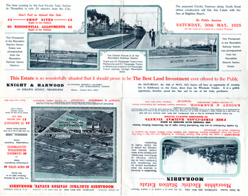
Flyer - Moorabbin Electric Station Estate, Moorabbin, 1925
... South Road... Cottage Museum) Joyce Park Jasper Road Ormond melbourne The train ...The train line from the city to Frankston was electrified which intensified the sale in the municipality of Moorabbin, particularly land which was in the vicinity of the railway stations.Example of the progress of the Municipality of MoorabbinAdvertising flyer for auction of real estate sales - plan of building blocks for saleMoorabbin Electric Station Estate, Moorabbin - Auction Saturday 30 May 1925 - 65 Residential allotments Auctioneer Knight & Harwoodmoorabbin station, south road, station street, jasper street (now redholme street), central avenue, moorabbin, real estate, auction -
 City of Moorabbin Historical Society (Operating the Box Cottage Museum)
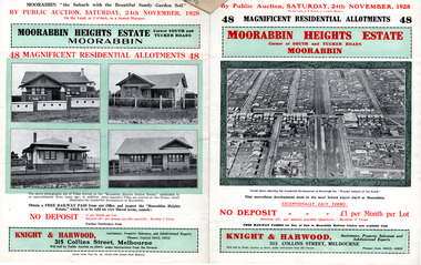
Flyer - Moorabbin Heights Estate, Moorabbin, 1928
... South Road... Bentleigh South Road Tucker Road Hinkler Avenue Real Estate Auction ...The train line from the city to Frankston was electrified which intensified the sale in the municipality of Moorabbin, particularly land which was in the vicinity of the railway stations.Example of the progress of the Municipality of MoorabbinAdvertising flyer for auction of real estate sales - plan of building blocks for saleMoorabbin Heights Estate, Moorabbin - 48 residential allotments - Auction Saturday 24 November 1928moorabbin, bentleigh, east bentleigh, south road, tucker road, hinkler avenue, real estate, auction -
 City of Moorabbin Historical Society (Operating the Box Cottage Museum)
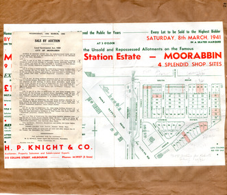
Flyer - Moorabbin Electric Station Estate, Moorabbin, 1941
... South Road... of the progress of the Municipality of Moorabbin South Road Station Street ...The train line from the city to Frankston was electrified in 1922 which intensified the sale in the municipality of Moorabbin, particularly land which was in the vicinity of the railway stations. Moorabbin Electric Station Estate Sale of unsold and repossessed Allotments, the original sale was on Saturday 30 May 1925.Example of the progress of the Municipality of MoorabbinAdvertising flyer for auction of real estate sales - plan of building blocks for saleMoorabbin Electric Station Estate, Moorabbin. Auction Saturday 8 March 1941 - 9 villa units 4 shop sitessouth road, station street, taylor street, healey street, jasper street (now redholme street), central avenue, moorabbin, real estate -
 Whitehorse Historical Society Inc.
Document, Land Subdivision, cnr Springvale and Burwood Roads, n.d
... South Springvale Road Vermont South Stanley Road Vermont South ...Hand drawn document of land subdivision,Hand drawn document of land subdivision, Springvale Road & Burwood Road, together with notes of various sales from 1857 to 1957.Hand drawn document of land subdivision, burwood road, vermont south, springvale road, vermont south, stanley road, vermont south, vermont south, mayne, alexander, mayne, james alexander, craig, silas gordon, fankhauser, frederick william, fankhauser, mervyn william, burrell, charles, donaldson, john -
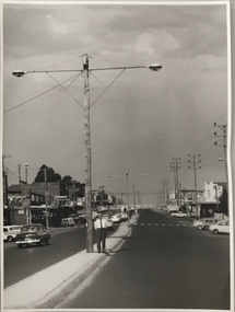
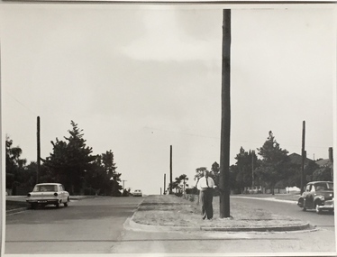
 Kew Historical Society Inc
Photograph, Stuart Tompkins Studio, Electricity Supply Poles, North Road, Ormond, 1965
... stuart tompkins studio, street lighting, south road... lighting, south road (moorabin) 1965 public infrastructure -- city ...Research provided by Stuart Tompkins Studio, Box Hill, into alternatives for median strip street lighting to be used in Burke Road, Kew. The photographers identified variants in different suburbs appropriate to Kew's needs.The series from which the photograph is drawn provides a snapshot by a commercial photographic studio of each named vicinity in 1965 as well as providing examples of public works infrastructure being commissioned by local government in the 1960s. The photos originally formed part of the Engineering Department's files in the City of Kew before being donated to the kew Historical Society.Electricity Supply Poles, North Road, Ormond, 1965. Electricity supply poles photographed for the Kew City Council by Stuart Tompkins Studio. The photograph of North Road, Ormond west of Jasper Road, looking east depicts wooden poles carrying two lamps in a median strip and with two on each side alternately. It was noted that the supply wires were from one side only. The poles were described as 3′ above ground and 11.25″ in diameter. The plan was to use this approach for Burke Road, Kew. [There are three copies of this photograph in the Collection.] Typed inscription on reverse: "Electricity Supply Poles. Photographed for Kew City Council 8/2/65. No.1 North Road - Ormond, west of Jasper Road, looking east. Wooden poles carrying two lamps in median strip and two on each side alternately just as is proposed for Burke Road, Kew. Supply wires from one side only. Poles 3' above ground 11 1/4" dia." Studio stamp: "Stuart Tompkins Studio. 547 Station Street, Box Hill. WX1439."stuart tompkins studio, street lighting, south road (moorabin) 1965, public infrastructure -- city of kew, city of kew -- engineer's department -
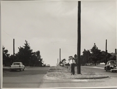
 Kew Historical Society Inc
Photograph, Stuart Tompkins Studio, Electricity Supply Poles, North Road, Ormond, 1965
... stuart tompkins studio, street lighting, south road... lighting, south road (moorabin) 1965 Typed inscription on reverse ...Research provided by Stuart Tompkins Studio, Box Hill, into alternatives for median strip street lighting to be used in Burke Road, Kew. The photographers identified variants in different suburbs appropriate to Kew's needs.The series from which the photograph is drawn provides a snapshot by a commercial photographic studio of each named vicinity in 1965 as well as providing examples of public works infrastructure being commissioned by local government in the 1960s. The photos originally formed part of the Engineering Department's files in the City of Kew before being donated to the kew Historical Society.Electricity Supply Poles, North Road, Ormond, 1965. Electricity supply poles photographed for the Kew City Council by Stuart Tompkins Studio. The photograph of North Road, Ormond west of Jasper Road, looking east depicts wooden poles carrying two lamps in a median strip and with two on each side alternately. It was noted that the supply wires were from one side only. The poles were described as 3′ above ground and 11.25″ in diameter. The plan was to use this approach for Burke Road, Kew. [There are three copies of this photograph in the Collection.] Typed inscription on reverse: "Electricity Supply Poles. Photographed for Kew City Council 8/2/65. No.1 North Road - Ormond, west of Jasper Road, looking east. Wooden poles carrying two lamps in median strip and two on each side alternately just as is proposed for Burke Road, Kew. Supply wires from one side only. Poles 3' above ground 11 1/4" dia." Studio stamp: "Stuart Tompkins Studio. 547 Station Street, Box Hill. WX1439."stuart tompkins studio, street lighting, south road (moorabin) 1965 -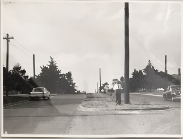
 Kew Historical Society Inc
Photograph, Stuart Tompkins Studio, Electricity Supply Poles, Burke Road, Kew, 1965
... stuart tompkins studio, street lighting, south road... lighting, south road (moorabin) 1965 Typed inscription on reverse ...Research provided by Stuart Tompkins Studio, Box Hill, into alternatives for median strip street lighting to be used in Burke Road, Kew. The photographers identified variants in different suburbs appropriate to Kew's needs.The series from which the photograph is drawn provides a snapshot by a commercial photographic studio of each named vicinity in 1965 as well as providing examples of public works infrastructure being commissioned by local government in the 1960s. The photos originally formed part of the Engineering Department's files in the City of Kew before being donated to the kew Historical Society.Electricity Supply Poles, Burke Road, Kew, 1965. This photograph of Burke Road, Kew was taken just north of Kilby and Doncaster Roads looking north. Stuart Tompkins Studio provided the photograph for the Kew City Council. In the photograph are a number of electricity supply poles that have been erected in the median strip, in addition to some new poles on each footpath. The nearest wooden pole is stated to be 13.5″ in diameter. The electricity poles in Burke Road required Kew Council to investigate comparable designs in other Melbourne municipalities. [There are three copies of this photograph in the Collection.] Typed inscription on reverse: "Electricity Supply Poles. Photographed for Kew City Council 8/2/65. No.5 Burke Road - Kew, just north of Kilby and Doncaster Roads looking north. Some of seven poles already erected in median strip. Shows also some new poles erected on each footpath. Nearest wooden pole 13 1/2" dia." Studio stamp: "Stuart Tompkins Studio. 547 Station Street, Box Hill. WX1439."stuart tompkins studio, street lighting, south road (moorabin) 1965 -
Glen Eira Historical Society
Letter - Rosstown Railway
... South Road... East Brighton Railway Station South Road Railway Routes Railway ...This file contains four items: 1/A black and white photocopy of a letter dated either 07/08/1889 or 09/08/1889, from Robert Lundon to an unidentified recipient discussing an agreement reached between the author – on behalf of the recipient – and Soon Hang Hi in regard, in regards to the allotment known as Webber’s. The agreement is outlined in the letter in what appears to be Chinese characters, and includes the marks of Robert Lundon and Soon Hang Hi. File note from Joy Wu states that the calligraphy is not Mandarin or traditional Chinese. 2/Three sheets of hand-written working notes with information taken from the Victorian Government Gazette on THE ROSSTOWN AND MURRUMBEENA LAND COMPANY LIMITED, THE ROSSTOWN JUNCTION RAILWAY AND PROSPERITY COMPANY LIOMITED, and THE ROSSTOWN JUNCTION, ELSTERNWICK, AND OAKLEIGH RAILWAY COMPANY LIMITED, covering dates between 1887 and 1894. The notes concern meetings and creditors claims relevant to the companies, with reference numbers for the information source. Date and author of the notes are not recorded. 3/A black and white photocopy of the a partial map of the Rosstown Railway and surrounding area, undated. The map includes the names of landholders in the areas of Brighton, Garden Vale and Elsternwick, as well as other railway lines present in the region. 4/A fold-out map and guide of the Rosstown Rail Trail, including a brief general history of Caulfield as well as a more extensive biography of William Murray Ross and the Rosstown Railway. The map marks and describes significant sites along the trail, including photographs of some of these sites, provided by DF Jowett.documents, correspondence, webber’s, lundon robert, chinese characters, ethnic communities, signatures, text, settlements, taxes, fraser john grieves, lovell r.h., price davies, meetings, communication activities, soon hang hi, commercial events and activities, the rosstown and murrumbeena land company limited, victorian government gazette, bulmer richard, parry john, osment henry, shareholders, creditors claims, the rosstown junction railway and property company limited, finch and best, lawyers, the rosstown junction elsternwick and oakleigh railway company limited, cameron w.c., phillips p.d., garden vale, elsternwick, elsternwick railway station, rosstown, rosstown railway, thomas street, bay street, kooyong road, melbourne and brighton railway, hawthorn road, bambra road, caulfield and frankston railway, booran road, grange road, koornang road, murrumbeena road, north road, north road railway station, east brighton railway station, south road, railway routes, railway lines, railways, land transport, murphy j., caulfield, hamilton t.f., dane p., holloway, webb, ailee john, payne t.b., brodie chas, dane john, o’neil h., mccombie john, mcmillane a., smyth c.d., cooper, ebden, landholders, jeffrey j.d., gill j., balcombe a.e., cooper h., mcnab j., white j., sutherland j., greeves a.f.a., newton m.c., chamley f.b., fowler j., inglis p., grant t., stooke j., swanson g., cochrane c., adams e.b., mccombie thas, keyes robert, brighton cemetery, burials grounds and graveyards, war-ein road, were j.b., holland j., mcmahon c., winter t.l.m., dendy henry, mitchell w., jackson s., were j.e., wickham francis dawe, bryant jane, east brighton railway station, railway stations, maps, allotments, land titles, roads and streets, rosstown rail trail, city of glen eira, tourism, trains, tourism information bureaus, tours, pamphlets, elsternwick railway park, oakleigh junction, princes park, ee gunn reserve, packer park, sites, jowett d.f., weickhardt i.g., return to rosstown: railways land sales and sugar beet ventures in caulfield, land sales, walking trails, ross william murray, transport objects, locomotion, walking, cycling, driving, sports, country mansions, people, caulfield john, builders, construction and demolition workers, occupations, careers, professionals, topography, geology, landforms, horticulture, market gardens, primary industry workers, city of caulfield, mood kee, pennington harold, annual general meetings, caulfield town hall, glen eira city council, carnegie, carnegie station, rosstown station, people by circumstance, migrants, sugar beet, sugar beet mill, sugar beet industry, mills, factories, sea beach lines, bent thomas, parliamentary representatives, neville street, miller street, lemann’s swamp reserve, koornang park, cane sugar industry, breweries, rabbit processing plants, health establishments, hospitals, food production establishments, abattoirs, thieves, social problems, vagrants, theft, squatting, financial economics, debt, finance industry, insurance companies, company managers, bentleigh, ross leila, the grange, leila road, wild cherry road, financial trouble, mortgages, gisborne street, archibald street, riddell parade, victoria railways, glen huntly road, clarence street, college street, gladstone parade, parrell street, aileen avenue, seaview street, land subdivisions, dover street, sussex street, landfill, marara road, booran road, woodville avenue, dorothy avenue, ormond park, royal avenue, ormond railway station, oakleigh road, melten avenue, miller street, munro avenue, lord reserve, neerim road, toolambool road, the rosstown hotel, rosanna street, murrumbeena crescent, commercial establishments, the national bank, rosstown road, kangaroo road, poath road, freda street, hughesdale kindergarten, oakleigh council, hughesdale community centre, civic establishments, galbally reserve, plaques, warrigal road, out and about brochures, orion estate -
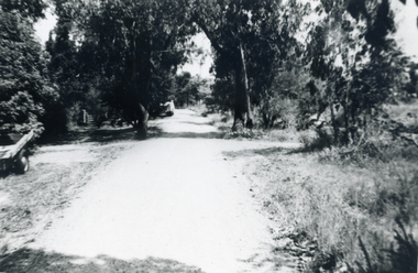
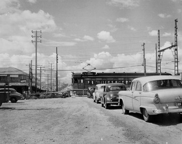 City of Kingston
Photograph - Black and white, c. 1957
... at South Road, Moorabbin. There is a 'Red Rattler' passenger train... depicting the railway crossing at South Road, Moorabbin ...This image depicts the increasing urbanisation of Moorabbin. While there are several cars in line waiting for the train to go through the crossing and the gates to open, in the distance there is a lot of activity on the road, with many cars.Black and white photograph depicting the railway crossing at South Road, Moorabbin. There is a 'Red Rattler' passenger train going through the level crossing travelling towards the city.Handwritten in blue ink on reverse: 57-4078 Handwritten in red ink on reverse: 82% Handwritten in black ink on reverse: Ch. 6moorabbin, trains, cars, urbanisation, suburbs -
 Queenscliffe Maritime Museum
Painting - Water colour painting of the schooner Argosy Lemal, Argosy Lemal, c. 1930's
... Albert Road South Melbourne established by his father G F Gregory...326 Albert Road, South Melbourne, Victoria, Australia... studio at 326 Albert Road South Melbourne established by his ...Arthur V Gregory b.1867, d.1957 worked from studio at 326 Albert Road South Melbourne established by his father G F Gregory in 1852. As Argosy Lemal the ship served as one of the early United States Army communications ships from 1942–1949.Water colour painting in painted gilt frameArgosy Lemal off Cape Otway A.V. Gregorya.v. gregory, water colour, argosy lemal -
 City of Moorabbin Historical Society (Operating the Box Cottage Museum)
Photograph - Map of Dendy's Special Survey, 1852 Map of Henry Dendy's Special Survey of 1841, 19th Century
... miles south from Melbourne, bounded by North Road, East Boundary... by North Road, East Boundary Road, South Road and to the west... miles south from Melbourne, bounded by North Road, East Boundary ...A Map drawn in 1852 that shows the 5,120 acres that formed Dendy's Special Survey of 1841. In 1840 Henry Dendy, a farmer in Surrey, England acquired a "Special Survey" from the Commissioners for Land and Emigration which gave Dendy the right to choose land in Port Phillip for the "bargain basement" price of only £1 per acre for 5120 acres, (an area of 8 square miles). The Special Survey also included the right to "the shipment of a worker for every £20 spent on land, whose free passage was paid by the Crown, equalling a total of 100 workers ". Accordingly Dendy sold his English holdings and paid the required £5120 and arrived in Melbourne in February 1841. However by this time land in the new colony was selling for £5 - £40 per acre. Because Henry Dendy possessed the order from the Colonial Office in London he was able to successfully oppose Governor LaTrobe's attempts to alter the price of the land. Dendy appointed Jonathan Were, (an entrepreneur, who had arrived in 1839), as his Manager and who later became a partner. Together, Dendy and Were decided on an area 5 miles south from Melbourne, bounded by North Road, East Boundary Road, South Road and to the west by Port Phillip Bay. Were and Dendy pitched their tents in the area now known as ' Park St, Brighton' and sank a well near the corner of 'St Andrew's St and Wells St'. By 1845 J.B Were and Company had bought almost half of Dendy's land and Were built himself "Moorabbin House" in Were St Brighton made from stone, quarried from local cliffs. It was still standing in 1924. Legend records Moorabbin is named after the Aboriginal word for ' Mother's Milk ' The soil is very fertile and well supplied with water especially in the area called 'East Brighton' - now known as Bentleigh and East Bentleigh - By 1850 the area had developed with numerous market gardens, dairy farms, fruit gardens and vineyards supplying food for the growing population of Melbourne.This Map shows the birth of the Brighton and Moorabbin area. On 18th January1859 Brighton was proclaimed a Municipality and a Borough by October 1863. Meanwhile, following a Petition, the area of East and South Brighton, incorporating Mordialloc, Cheltenham, Mentone, Sandringham and Oakleigh separated from Brighton to form the Moorabbin District Roads Board becoming the first Local Government Authority. Col. William Mair was elected as the first Chairman of the Moorabbin Roads Board. Moorabbin Shire 1871 developed further and was declared a City in1934. The City of Moorabbin was the largest Municipality in Melbourne before the Amalgamation of Councils in 1994 when it was divided in the south to City of Kingston and in the north to City of Glen Eira A Photo-lithographed 1852 Map showing the 5,120 acres that formed Dendy's Special Survey of 1841. Henry Dendy & Jonathan Were chose an area 5 miles south from Melbourne, bounded by North Road, East Boundary Road, South Road and to the west by Port Phillip Bay. Moorabbin County of Bourke / Photo-Lithographed at the department of Lands and Survey. /Melbourne. / Price 1/- brighton, moorabbin, bentleigh, cheltenham, dendy henry, bent thomas, were jonathan, special survey -
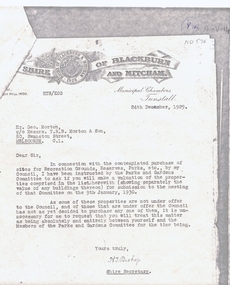 Whitehorse Historical Society Inc.
Legal record - Correspondence, Public Open Spaces, 24/12/1929 12:00:00 AM
... blackburn south canterbury road whitehorse road nunawading glendale ...Letter from H.T. Bishop, Shire Secretary, Shire of Blackburn and Mitcham to Mr Geo. Morton requesting valuation of landLetter from H.T. Bishop, Shire Secretary, Shire of Blackburn and Mitcham to Mr Geo. Morton requesting valuation of land for sale for the Parks and Gardens Committee, dated 24 / 12 / 1929. Valuations provided by Geo. Martin dated 6/ 1 / 1930.Letter from H.T. Bishop, Shire Secretary, Shire of Blackburn and Mitcham to Mr Geo. Morton requesting valuation of land land values, shire of blackburn and mitcham, bishop, herbert thomas., morton, george, main street, blackburn, gardenia street, husband road, forest hill, surrey road, holland road, blackburn south, canterbury road, whitehorse road, nunawading, glendale street, williams road, south parade, tunstall -
 Lakes Entrance Historical Society
Photograph, Punt Road Metung Victoria, 1/06/1999 12:00:00 AM
... Also a colour photograph looking South from Punt Road... Victoria. Also a colour photograph looking South from Punt Road...Also a colour photograph looking South from Punt Road ...Also a colour photograph looking South from Punt Road Metung 04460.1 10 x 15 cmColour photograph looking Northwest from Punt Road Metung Victoria. Also a colour photograph looking South from Punt Road Metung township, waterways, boats and boating, boardwalk -
Whitehorse Historical Society Inc.
Article, Livingstone School Has Schedule, 21/10/1976 12:00:00 AM
... in Livingstone Road, Vermont South, due to open in 1978...Plans for the new Primary School in Livingstone Road... Mitcham melbourne in Livingstone Road, Vermont South, due to open ...Plans for the new Primary SchoolPlans for the new Primary School in Livingstone Road, Vermont South, due to open in 1978, on display.Plans for the new Primary Schoolprimary schools, walton, trevor, vermont south primary school -
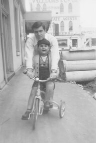 Ithacan Historical Society
Photograph, Cousins, c
... business located on the corner of Osborne Street and Toorak Road...Toorak Road, South Yarra, Victoria, Australia... of Osborne Street and Toorak Road, South Yarra. Hector's father ...Hector Sikiotis (Skiotis) was supervising his cousin, young Jim Morris when he was riding his tricycle outside the family business located on the corner of Osborne Street and Toorak Road, South Yarra. Hector's father established in China where Hector was born. They later returned to Ithaca and migrated to Australia in the 1950s where together with his brother Denis studied at RMIT. For more information of the Skiotis family story go to www.ithaca.org.au/images/Historical_Stories/Ed_192_Art_2_Skiotis_of_China.pdfA black and white photograph of a young man helping a little boy, who is riding a tricycle on a footpath. -
 Whitehorse Historical Society Inc.
Photograph, Canterbury Road, C.1967
... Black and white photo of Service Road on south side... and white photo of Service Road on south side of Canterbury Road ...Black and white photo of Service Road on south side of Canterbury Road.canterbury road vermont, service roads -
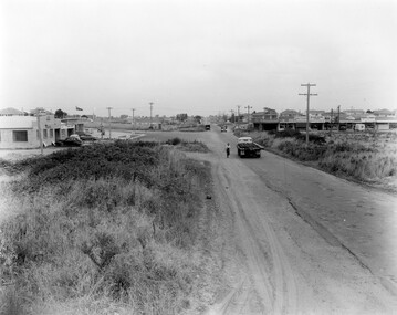 City of Kingston
Photograph - Black and white, 1957
... Black and white photograph of the intersection of South... of the intersection of South Road and Chesterville Road, Moorabbin. A service ...This image shows the increasing urbanisation of the formerly rural area of Moorabbin.Black and white photograph of the intersection of South Road and Chesterville Road, Moorabbin. A service station is visible on the left hand side, a truck is travelling along the road and shops are under construction on the right hand side.Handwritten in blue ink on reverse: 57-523B Handwritten in red ink on reverse: 100%moorabbin, shopping strip, paddocks, roads, cars -
Whitehorse Historical Society Inc.
Map, Mitcham, 1880s?
... Hand drawn map of area north and south of Whitehorse Road... Canterbury Road Mitcham Hand drawn map of area north and south ...Hand drawn map of area north and south of Whitehorse Road and South of Canterbury Road c.1880-1900.Hand drawn map of area north and south of Whitehorse Road and South of Canterbury Road c.1880-1900. Probably sketched by a McClare descendant. Includes locations and names of settlers of that time.Hand drawn map of area north and south of Whitehorse Road and South of Canterbury Road c.1880-1900. whitehorse road, mitcham, mitcham road, mitcham, l l vale road, vermont, canterbury road, mitcham -
Glen Eira Historical Society
Plan - Clarinda Street, 27, Caulfield South
... Sycamore Road South Caulfield Glenhuntly Road Plan Clarinda Street ...A one page typed letter from Plante and Henty Solicitors on behalf of the Executor of the will of the late Grace Ellen Gillespie, to W V Scott of S P Simmonds and Co, dated 04/03/1957, requesting valuation of 27 Clarinda Street, Caulfield South for Probate purposes. The letter is accompanied by the Certificate of Title for the property which includes a map (87mm x 67mm) of the property. It is also accompanied by a floor plan (300mm x 205mm) of the house. The file also includes a two page copy of correspondence from W V Scott to Plante and Henty, dated 22/03/1957, providing the valuation of 27 Clarinda Street. The file also includes three pages of handwritten working notes for the purposes of the valuation which provide dimensions and estimated value of the property.scott w v, gillespie grace ellen, clarinda street, solicitors, s p simmonds and co estate agents, property values, land values, plans, architectural features, land titles, certificates, caulfield south, prahran east, elsternwick county of bourke, sycamore road, south caulfield, glenhuntly road -
Whitehorse Historical Society Inc.
Document - Report, Frank Isaac White, 01/06/1997
... menin road south military cemetry... and buried in the Menin Road South Cematery at Ypres. Photographs... white frank isaac menin road south military cemetry ww1 war ...Photocopy of a Luther Collage assignment on visits to war memorials and an investigation of Frank Isaac White, a name on the Mitcham War Memorial. White served in Egypt and France,. Maps show the route of his journeys including a period in hospital in England. Information is given about soldiers living conditions and his role as a artillery man. He was killed in Belgium on 20th September 1917 and buried in the Menin Road South Cematery at Ypres. Photographs of the cemetary are included and of his grave.white, frank isaac, menin road south military cemetry, ww1, war memorials -
Glen Eira Historical Society
Document - Grange Road, 77, Glen Huntly
... Road, south west corner with Neerim Road, then in the suburb...Grange Road, south west corner of Neerim Road, Glen Huntly... Road, south west corner with Neerim Road, then in the suburb ...This file contains one item about the sale and history of the then unnumbered property and the first owners of the home at 77 Grange Road, south west corner with Neerim Road, then in the suburb of Carnegie: 1/ A typed sheet with the details and documents that were given to the society in 1987. These are biographical details provided by the son of Hulbert Gorrie, a Chemist who worked at Rankin and Eyval Chemists shop at 165 Glenhuntly Road (from around 1920 to 1957). Hulbert and his wife Gertrude Gorrie purchased the vacant block and built the first house at the address in 1936. The photo mentioned of Hulbert at the shop is held in our file 1080A Glenhuntly Road Elsternwick. gorrie gertrude, gorrie hulbert hopetoun, barnard ernest franklin, hobart john bertram, grange road, neerim road, elsternwick, contract of sale of land, dwelling, land, e.j & h amos, hintons nursery, real estate agents, builder, glen huntly, coorigil road, murrumbeena, emma st, caulfield, parish of prahran, caulfield county of bourke, legal document, chemist, rankin and eyval shop, glenhuntly road, carnegie, glen huntly road -
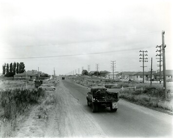 City of Kingston
Photograph - Black and white, c. 1957
... Black and white photograph looking west along South Road... photograph looking west along South Road. There is a truck ...This image shows the urbanisation of a formerly rural area of Moorabbin.Black and white photograph looking west along South Road. There is a truck in the foreground, travelling along the sealed South Road. A car is waiting to exit from Rowan Road. People are walking along the left hand side of the road, and a young person a bike is riding along the right side. They are all going in the same direction as the traffic. The left hand side of the image shows paddocks in the foreground, which houses further back. The right hand side of the image shows suburban houses with electricity poles running the length of the road. Handwritten in blue ink on reverse: 57-523A Handwritten in red ink on reverse: 85% Handwritten in black ink or grey lead: Ch. 6moorabbin, cars, roads, housing -
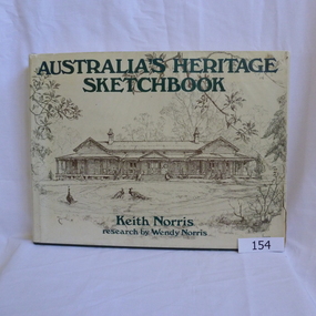 Greensborough Historical Society
Book, Paul Hamlyn Pty Limited, Australia's Heritage Sketchbook: by Keith Norris and Wendy Norris, 1976_
... 176 South Creek Road, Dee Why West, NSW, 2099 ...Sketches of historic building from around AustraliaRecords notable Australian buildings358pages. Illustrated with line sketches. Hard cover, green. Dust jacket contains sketch of old house near Toowoomba Qld on front and sketch of old jewellery shop in Charters Towers Qld on back cover.Name and address of owner on two pages (W. A. Partington/Alan Partington)partington-family historic-buildings wendy-norris keith-norris -
 Anglesea and District Historical Society
Book, Paul Hamlyn Pty Ltd, My First Pet: by Beverley R Eggins. Illustrated by Gillian Tomblin, 1974
... 176 South Creek Road, Dee Why West, New South Wales ...A Paul Hamlyn Learning Bookpaul hamlyn, pet, guinea pigs