Showing 1537 items
matching state primary school
-
 Kew Historical Society Inc
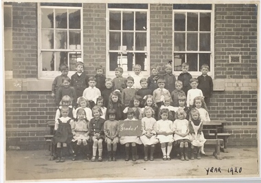
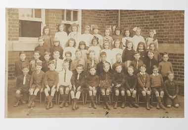
Photograph, Grade 1, Kew State School, 1920
... schools - kew (vic.) primary schools -- kew (vic) kew state school ...Kew Primary School is the oldest school in Kew and was established on November 1, 1870. It predates the commencement of State education with its genesis lying in the year the colony was founded, namely, 1851. Nicholas Fenwick was recognized as the founder of Kew when he purchased an area of 122 acres (Lot 87) on which Kew Primary School now stands.Photograph of 35 children in Grade 1, Kew State School, 1920. Inscription on front "Year 1920"; on reverse: "KH-285. Kew S. School. Donated by Mr Heward, 1978. Grade 1 1920." This photo, unlike 1978.0019 is on a cardboard mount.schools -- kew (vic.), government schools - kew (vic.), primary schools -- kew (vic), kew state school, kew primary school -
 Kew Historical Society Inc
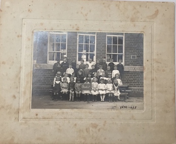
Photograph, J F Armstrong, Grade 6, Kew State School, 1926
... kew state school, kew primary school... Primary School now stands. kew state school, kew primary school ...Kew Primary School is the oldest school in Kew and was established on November 1, 1870. It predates the commencement of State education with its genesis lying in the year the colony was founded, namely, 1851. Nicholas Fenwick was recognized as the founder of Kew when he purchased an area of 122 acres (Lot 87) on which Kew Primary School now stands.Grade 6, Kew State School, 1926. Inscription on front: "Year 1926." and reverse: "KH-283. Kew State School. Donated by Mr Heward 1978." On mount - Photographer: "J Armstrong / 4 Armadale St., Northcote"kew state school, kew primary school, schools -- kew (vic.), government schools -- kew (vic.), primary schools -- kew (vic.) -
 Kew Historical Society Inc
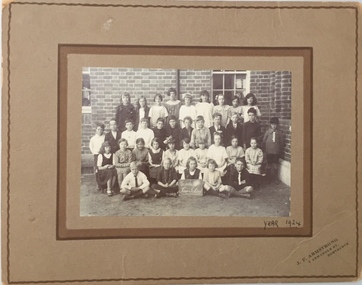
Photograph, Grade 5, Kew State School, 1925
... kew state school, kew primary school... state school, kew primary school Inscription on front: "Year ...Grade 5, Kew State School, 1925. Inscription on front: "Year 1925." and reverse: "KH-282. Grade 5, Kew State School. Donated by Mr Heward 1978."kew state school, kew primary school -
 Kew Historical Society Inc
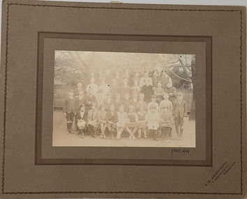
Photograph, J F Armstrong, Grade 4, Kew State School, 1924
... kew state school, kew primary school... Primary School now stands. kew state school, kew primary school ...ew Primary School is the oldest school in Kew and was established on November 1, 1870. It predates the commencement of State education with its genesis lying in the year the colony was founded, namely, 1851. Nicholas Fenwick was recognized as the founder of Kew when he purchased an area of 122 acres (Lot 87) on which Kew Primary School now stands.Grade 4, Kew State School, 1924. Inscription on front: "Year 1924." and reverse: "KH-284. Grade IV, Kew State School. Donated by Mr Heward 1978."kew state school, kew primary school, government schools -- kew (vic), primary schools -- kew (vic) -
 Kew Historical Society Inc
Photograph, Grade 1, Kew State School, 1920
... kew state school, kew primary school... Primary School now stands. kew state school, kew primary school ...Kew Primary School is the oldest school in Kew and was established on November 1, 1870. It predates the commencement of State education with its genesis lying in the year the colony was founded, namely, 1851. Nicholas Fenwick was recognized as the founder of Kew when he purchased an area of 122 acres (Lot 87) on which Kew Primary School now stands.Grade 1, Kew State School, 1920. Inscription on front: "Year 1920". See similar 1978.0015.kew state school, kew primary school, primary schools -- kew (vic), government schools-- kew (vic.) -
 Kew Historical Society Inc
Photograph, Grade 2, Kew State School 1075, 1921
... kew state school, kew primary school... Primary School now stands. kew state school, kew primary school X ...Kew Primary School is the oldest school in Kew and was established on November 1, 1870. It predates the commencement of State education with its genesis lying in the year the colony was founded, namely, 1851. Nicholas Fenwick was recognized as the founder of Kew when he purchased an area of 122 acres (Lot 87) on which Kew Primary School now stands.Grade 2, Kew State School, 1075, 1921. Xkew state school, kew primary school -
 Kew Historical Society Inc
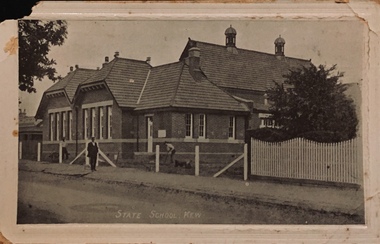
Postcard, State School, Kew
... -- schools -- kew (vic.) kew state school kew primary school ...One of a number of 'real photo' and commercial postcards created by or owned by members of the Christian and Washfold families of Kew. The postcards are part of a larger collection of photographs, postcards and publications donated to the collection in May 2021.Sepia postcard of Kew State School and what appears to be the building of a new fence. Note the fleche towers on the roof at right. postcards -- schools -- kew (vic.), kew state school, kew primary school, christian-washfold collection -
 Port Fairy Historical Society Museum and Archives
Photograph, c.1999
... primary state school... Street consolidated school primary state school port fairy pupils ...Former pupils of Port Fairy Consolidated School 1874/1979 "125 Years Back To Celebrations"125 years of the Port Fairy State School/Consolidated School Polding StreetColoured photographconsolidated school, primary state school, port fairy, pupils, reunions -
 Canterbury History Group
Photograph - Canterbury State School, c1918
... melbourne Canterbury Canterbury State School Primary Schools ...Black and white photograph of students (in Infant Grade?) Canterbury State School approx 1918. Boy 4th from the left was George Cottell.Girl 1st on the right in front Edna? Tollcanterbury, canterbury state school, primary schools, students, cottell family, toll family -
Canterbury History Group
Photograph - Infant Grade Canterbury State School 3572, 1920
... melbourne Canterbury Canterbury State School Primary Schools ...Infant grade of Canterbury State School in 1920. 70 children in the photo including Dr. Allan Williams. 4 teachers. sepia photograph.canterbury, canterbury state school, primary schools, students, teachers, williams> allan(dr.) -
Canterbury History Group
Photograph - Grade 4b Canterbury State School 3572, 1924
... melbourne Canterbury Canterbury State School Primary Schools ...Grade 4b of Canterbury State School, 3572 in 1924. 52 children, some named on the back of the photograph. sepia photocanterbury, canterbury state school, primary schools, students, williams> allan (dr.), caffin family -
Canterbury History Group
Photograph - Balwyn State School no 1026 Grade.4, 1900-2
... melbourne Canterbury Balwyn State School Primary Schools Balwyn Road ...Photo taken about 1900-2 during the Boer War of Grade 4 at Balwyn State School Headmaster was Mr Bennett father of Major General Gordon Bennett. Gordon Bennett appears in the photograph in cadet uniform, another student is Ruby Kathleen Butler mother of Marion Millett (nee Spiller)canterbury, balwyn state school, primary schools, balwyn road, bennett> gordon (major general), spiller family, boer war -
 Linton and District Historical Society Inc
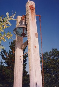
Photograph, Linton Primary School Bell, 1988, 1988
... Linton State School Linton Primary School Colour photograph ...Taken April 23-24 1988, during Heritage Week.Colour photograph of bell at Linton Primary School. Bell has long chain attached and is mounted between two high posts.school bell, linton state school, linton primary school -
 Buninyong Visitor Information Centre
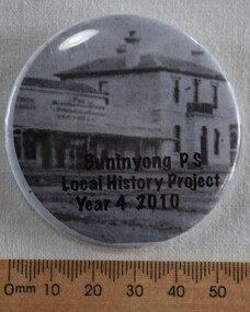
Ceremonial object - Badge, Badge-a-Minit, Buninyong PS Local History Project Year 4 2010, 2010
... State School Buninyong Primary School Education Badges Buninyong ...A badge made to celebrate a history project conducted by Year 4 at Buninyong Primary School in 2010Large round badge in grey tones showing the old bank and shops in centre of Buninyong.Buninyong PS Local History Project Year 4 2010buninyong state school, buninyong primary school, education, badges -
 Buninyong Visitor Information Centre
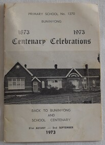
Document - Programme, Primary School No. 1270 Buninyong Centenary Celebrations 1873 - 1973, 1973
... and Bus Tour. Buninyong State School Buninyong Primary School ...Printed programme of events celebrating the school centenary including a Debutante Ball, Procession, School Roll Call, School Dinner, Concert, Church Service, Luncheon and Bus Tour. White single folded card with photograph of Buninyong Primary School, No. 1270 and the programme of activities from 31 August to 2 September, 1973buninyong state school, buninyong primary school, education, community, celebrations -
 Ballarat Heritage Services
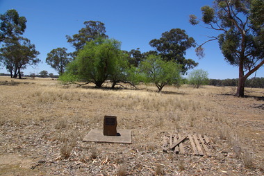
Photograph - School site, Site of the former Kurting State School, 2016, 10/01/2016
... kurting primary school Site of Kurting State School N0. 2026 1878 ...The Kurting State School No 2353 opened in 1881. The name changed to Hope Creek State School in 1893 and then in 1928 became the Powlett State School. The school burnt down in 1944 with school being held in the hall until the end of 1945. In 1946, the children of the area were bused to Inglewood. [Kurting - 808, Kurting - 2026 and Kurting - 2353]A plaque indicating the site of the Kurting Primary School. Site of Kurting State School N0. 2026 1878 - 1947 Project of Loddon Shire Council 2-4-2000kurting, kurting state school, kurting primary school -
 Greensborough Historical Society
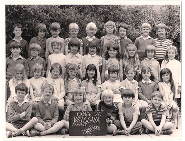
Photograph - School Photograph - Digital Image, Watsonia Primary School Wa4838 1972 Grade 2C, 1972_
... 2C watsonia state school watsonia primary school Black ...Class photograph from Watsonia Primary School, 1972 Grade 2CBlack and white photograph of school classwatsonia state school, watsonia primary school -
 Halls Gap & Grampians Historical Society
Photograph - B/W
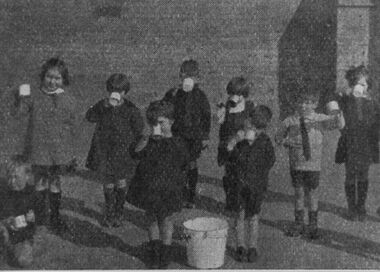
... During the 1940's and 1950's, all State Primary Schools... and 1950's, all State Primary Schools gave students fresh milk ...During the 1940's and 1950's, all State Primary Schools gave students fresh milk during the 'summer' months. In the Hall's Gap/Stawell area hot cocoa was given to the students in 'winter' months.The photo shows a group of nine primary school students drinking from mugs. Eight children are standing and one is squatting down. They are in a yard and there is a light coloured pail in the centre.education, schools -
 Kinglake Historical Society
Kinglake State School
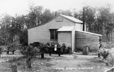
... kinglake, state, school, primary, building..., school, primary, building Photograph of KInglake State School ...kinglake, state, school, primary, buildingPhotograph of KInglake State School original building with teachers residence attached, opened in October 1879 and burnt down in February 1927 -
 Eltham District Historical Society Inc
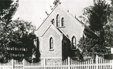
Photograph, Eltham Methodist Church, 1909, 1909
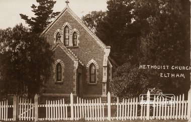
... Primary School (No. 209) building which collapsed in 1874 and were... Primary School (No. 209) building which collapsed in 1874 and were ...Situated at 810 Main Road on the corner of John Street. The Church was surrounded by a picket fence and tall pine trees. The Church was built by George Stebbings in the 1850s and is an example of fine craftmanship. Formerly Wesleyan, Methodist then Uniting church; the foundations of the church building were constructed with stone from the walls of the first Eltham State Primary School (No. 209) building which collapsed in 1874 and were purchased by Robert David Taylor. REVISED STATEMENT OF SIGNIFICANCE, CONTEXT, 2010 via Victorian Heritage Database What is significant? The 1880 bichromatic brick church and the surrounding site to the title boundaries. How is it significant? The church is architecturally, historically, socially and spiritually significant to the Shire of Nillumbik. Why is it significant? The church is architecturally significant as a finely detailed example of a brick 19th century rural community church, one of only four in the Shire (Criteria E & B). The church is historically significant as an important link with the time when Eltham was a small, insular country settlement. Also for the historical evolution visible in the complex, with the modest 1880s church and larger red brick rear hall from the early 20th century as a reflection of population growth in the area (Criterion A). The church is historically, spiritually and socially significant because it has played, and continues to play, an important part in the spiritual and social life of the community (Criterion G).Sepia postcard of Eltham Methodist Church, 1909eltham, methodist church, church, state school no. 209, eltham state school, robert david taylor, eltham uniting church, uniting church, wesleyan church -
 Sunbury Family History and Heritage Society Inc.
Photograph, Bulla Primary School
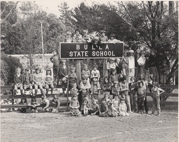
... state school to primary school and former high schools.... The title for schools from Prep to Grade 6 changed from state school ...In the mid 1980s the names of all government schools were changed. The title for schools from Prep to Grade 6 changed from state school to primary school and former high schools, with a few exceptions, became known as secondary colleges. This photograph was taken before the school's name was changed from Bulla State School to Bulla Primary School. A black and white photograph of children at the Bulla State School with their teachers photographed at the school gate and standing around the school sign. bulla primary school, schools -
 Bendigo Historical Society Inc.
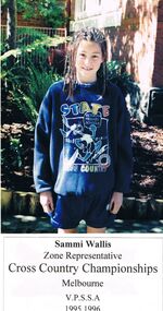
Photograph - GOLDEN SQUARE LAUREL STREET P.S. COLLECTION: PHOTOGRAPH - SAMMI WALLIS
... Victorian Primary Schools Cross Country Championships... shorts and a blue windcheater with State Victorian Primary ...Coloured photograph of Sammi Wallis. Zone Representative. Cross Country Championships, Melbourne. V.P.S.S.A. 1995 1996. Sammi is wearing blue shorts and a blue windcheater with State Victorian Primary Schools Cross Country Championships. There is a rabbit dressed in t shirt and shorts running between the rows of words.education, primary, golden square laurel st p.s., golden square laurel street p.s. collection - photograph - sammi wallis -
 Bacchus Marsh & District Historical Society
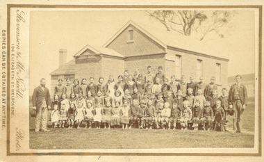
Photograph, Coimadai State School teachers and students 1883
... year in 1893. This school still operates as a state primary... year in 1893. This school still operates as a state primary ...Coimadai is a rural community located 10km north of Bacchus Marsh. The Coimadai School was opened in 1862. It was at first entirely funded by the local residents in the area. In these early years it was known as the Pyrete School after the nearby creek of that name. The building shown in this 1883 image was constructed in 1872 and replaced an earlier wooden structure. Over time the Coimadai School became a government funded and administered school. A famous pupil to attend the school was John Cain Senior, Premier of Victoria in the 1940s and 1950s, who attended the school for one year in 1893. This school still operates as a state primary school.Small sepia unframed photograph on card with gold border framing photograph. Housed in the album, 'Photographs of Bacchus Marsh and District in 1883 by Stevenson and McNicoll'. The image is a large group portrait of the pupils of the Coimadai State School and their two male teachers. There are about 60 pupils. The older children are standing in rows and a younger group of pupils is seated on forms or benches in front of them. One teacher stands on the right of the group of pupils and the other is on the left. The School building can be seen in the background.On the front: Stevenson & McNicoll. Photo. 108 Elizabeth St. Melbourne. COPIES CAN BE OBTAINED AT ANY TIME. On the back: LIGHT & TRUTH inscribed on a banner surmounted by a representation of the rising sun. Copies of this Portrait can be had at any time by sending the Name and Post Office Money Order or Stamps for the amount of order to STEVENSON & McNICOLL LATE BENSON & STEVENSON, Photographers. 108 Elizabeth Street, MELBOURNE schools, schools coimadai vic., stevenson and mcnicoll 1883 photographs of bacchus marsh and district -
 Bendigo Historical Society Inc.
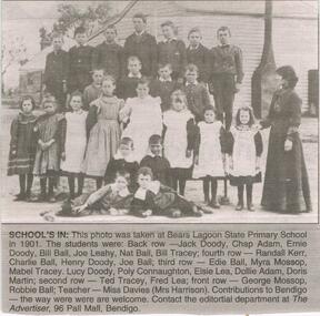
Newspaper - JENNY FOLEY COLLECTION: SCHOOL'S IN
... , 2004. School's in: photo taken at Bears Lagoon State Primary... taken at Bears Lagoon State Primary school in 1901. The students ...Bendigo Advertiser "The way we were" from Friday, July 30, 2004. School's in: photo taken at Bears Lagoon State Primary school in 1901. The students were, back row: Jack Doody, Chap Adam, Ernie Doody, Bill Ball, Joe Leahy, Nat Ball,Bill Tracey. Fourth row: Randall Kerr, Charlie Ball, Henry Doody, Joe Ball. Third row: Edie Ball, Myra Mossop, Mabel Tracey, Lucy Doody, Poly Connaughton, Elsie Lea, Dollie Adam, Doris Martin. Secon row: Ted Tracey, Fred Lea. Front row: George Mossop, Robbie Ball, Teacher Miss Davies (Mrs Harrison).newspaper, bendigo advertiser, the way we were -
 Eltham District Historical Society Inc
Photograph, Tom Prior, Methodist Church, Eltham
... Primary School (No. 209) building which collapsed in 1874 and were... Primary School (No. 209) building which collapsed in 1874 and were ...Situated at 810 Main Road on the corner of John Street. The Church was surrounded by a picket fence and tall pine trees. The Church was built by George Stebbings in the 1850s and is an example of fine craftmanship. Formerly Wesleyan, Methodist then Uniting church; the foundations of the church building were constructed with stone from the walls of the first Eltham State Primary School (No. 209) building which collapsed in 1874 and were purchased by Robert David Taylor. The Reynolds/Prior Photograph Collection, Presented to the Eltham District Historical Society, 14 June 2006 by Ross McDonald. A second copy was also presented to the Andrew Ross Museum, Kangaroo Ground The Reynolds family were early settlers in Research. Reynolds Road is named after this family. RERVISED STATEMENT OF SIGNIFICANCE, CONTEXT, 2010 What is significant? The 1880 bichromatic brick church and the surrounding site to the title boundaries. The church is architecturally, historically, socially and spiritually significant to the Shire of Nillumbik. Why is it significant? The church is architecturally significant as a finely detailed example of a brick 19th century rural community church, one of only four in the Shire (Criteria E & B). The church is historically significant as an important link with the time when Eltham was a small, insular country settlement. Also for the historical evolution visible in the complex, with the modest 1880s church and larger red brick rear hall from the early 20th century as a reflection of population growth in the area (Criterion A). The church is historically, spiritually and socially significant because it has played, and continues to play, an important part in the spiritual and social life of the community (Criterion G). - Victorian Heritage Database The Reynolds family were early settlers in Research. The Reynolds/ Prior collection of photographs were taken by Tom Prior, the maternal uncle of Ivy Reynolds, around 1900 and the 60 photos in the album give a fine overview of many of the landmarks of Research and Eltham over 100 years ago. lvy lived in the family home for many years at 106 Thompson Cres Research. Ivy's father, Ernst Richard Reynolds and grandfather, Richard Reynolds, lived at the same address. Ivy's father Richard worked for Mr. Trail on his property in Research. Reynolds Road is named after the family. Mr Tom Prior (wife Eva) worked at the Melbourne zoo. He was very innovative and made his own camera, using the black cloth hood to exclude the light. The photographs are a reminder of the rural nature of Research and Eltham and its rich heritage. Black and white photograph mounted in an album, the Reynolds/Prior Photograph Collection, this being one of 53 reproduced black and white images of early Eltham."Methodist Church" reynolds prior collection, eltham, methodist church -
 Kew Historical Society Inc
Plan - Subdivision Plan, Belford Heights Estate, Kew, ca. 1925
... . The plan includes the original location of East Kew State (Primary... includes the original location of East Kew State (Primary) School ...Pru Sanderson, in her groundbreaking ‘City of Kew Urban Conservation Study : Volume 2 - Development History’ (1988), summarised the periods of urban development and subdivisions of land in Kew. The periods that she identified included 1845-1880, 1880-1893, 1893-1921, 1921-1933, 1933-1943, and Post-War Development. These periods were selected as they represented periods of rapid growth or decline in urban development. An obvious starting point for Sanderson’s groupings involved population growth and the associated economic cycles. These cycles also highlighted urban expansion onto land that was predominantly rural, although in other cases it represented the decline and breakup of large estates. A number of the plans in the Kew Historical Society’s collection can also be found in other collections, such as those of the State Library of Victoria and the Boroondara Library Service. A number are however unique to the collection.The Kew Historical Society collection includes almost 100 subdivision plans pertaining to suburbs of the City of Melbourne. Most of these are of Kew, Kew East or Studley Park, although a smaller number are plans of Camberwell, Deepdene, Balwyn and Hawthorn. It is believed that the majority of the plans were gifted to the Society by persons connected with the real estate firm - J. R. Mathers and McMillan, 136 Cotham Road, Kew. The Plans in the collection are rarely in pristine form, being working plans on which the agent would write notes and record lots sold and the prices of these. The subdivision plans are historically significant examples of the growth of urban Melbourne from the beginning of the 20th Century up until the 1980s. A number of the plans are double-sided and often include a photograph on the reverse. A number of the latter are by noted photographers such as J.E. Barnes.The Belford Heights Estate was a subdivision in Kew East, even though the title of the plan indicates that it was located in Kew. The subdivision had been approved by 1915, and included 105 lots facing Strathalbyn, Kitchener, Hamilton and Beresford Streets, as well as Balfour and Belford Roads. Those lots hand coloured with red probably represent blocks that had been sold. The additional information provided on the plan is also of interest. The plan includes the original location of East Kew State (Primary) School in Strathalbyn Street, which opened in 1892. The inset Locality Plan also includes the route of the Outer Circle Railway and the location of the Wilsmere and East Kew Stations. The location of the landmark Harp of Erin Hotel is also marked on the Locality Plan.belford heights estate, subdivision plans - kew -
Ringwood and District Historical Society
Report book, Department of Education, Ringwood State School 2997 Inspector's Report Book Feb 1923-May 1933, 1923-1933
... Collected from Ringwood Primary State School No.2997 when... State School No.2997 when it closed in 1998. The handwritten 80 ...Collected from Ringwood Primary State School No.2997 when it closed in 1998. The handwritten 80 pages cover assessment of the subjects taught, discipline and classroom layouts.Inspector's report book labelled 7 orange invoices for Victorian Reading Books - grey covers with cream cloth spine, 80 pages all used -
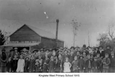 Kinglake Historical Society
Kinglake West Primary School
... Photograph of original Kinglake West Primary (State) School... of original Kinglake West Primary (State) School building ...Photograph of original Kinglake West Primary (State) School building with children and families. School built in 1896 by the pioneering families as Education Department would not build a school. Built on land selected by the Snell family.Only known photograph of the original school buildingPhotograph of original Kinglake West Primary School building education, school, pioneers, kinglake west -
 Federation University Historical Collection
Photograph - Photographs - Black and White, Ballarat Teachers' College
... at different locaitons. .1) Dana Street Primary School (State School... primary school ballarat east library gillies street State College ...These images were hung in the corridor of the University of Ballarat School of Education (Mount Helen). It most probably dates from around the time of the transfer of the College. The Ballarat Teachers' College was established after the Victorian State Government and the State Education Department decided to establish two provincial teachers' colleges, at Ballarat and Bendigo. On 04 May 1926 W.H. Ellwood (Principal), Miss A. Bouchier, and Mr A.B. Jones, welcomed the first enrolment of 61 students to undertake the one year course. In 1927 the College moved to the former Ballarat East Town Hall in Barkly Street, which was remodelled for their use. It closed in December 1931 due to the Great Depression. In 1946 Ballarat Teachers' College reopened and relocated to the Dana Street State School. The building used by the Teachers' College was the original bluestone building facing Doveton Street South. It was originally planned to open as a women's college, for whom the residence at 130 Victoria Street was purchased, but the decision was made to admit resident men from Ballarat. Mr T.W. Turner was appointed as Principal in 1951 and directed the introduction of a two year course for the Trained Primary Teachers' Certificate. The former one year course was terminated at the end of 1951. In 1958 the College was relocated to a custom built facility at Gillies Street, in close proximity to the Ballarat Botanical Gardens. Numbers increased with the introduction of the Trained Infant Teachers' Certificate course under the guidance of Mary Egan. With the introduction of a three year Diploma Course in 1968 accommodation became cramped. The introduction of the Diploma of Teaching (Primary) led to the Trained Infant Teachers' Certificate being discontinued in 1969, and the end of the Trained Primary Teachers' Certificate in 1969. Secondary Art and Craft students began studies at Ballarat Teachers' College in 1969 under Mr Ted Doney. In 1971 Mr D. Watson was appointed Principal. The State College of Victoria was proclaimed by Order in Council on 24 July 1973, and Ballarat Teachers' College became a constituent college of the State College of Victoria, and was known as State College of Victoria, Ballarat. By 1975 the College moved to Mount Helen as part of the Ballarat College of Advanced Education. Pre service teachers currently undertake their studies on the Mount Helen Campus of Federation University. ("Ruffians Attempted to Carry of the School Tent: A History of State Education in Ballarat", 1974, p73-4.)Three photographs of the Ballarat Teachers' College, all at different locaitons. .1) Dana Street Primary School (State School) .2) Barkly Street - former Ballarat East Town Hall .3) Gillies StreetBrass plaque on each framed photograph .1) Ballarat Teachers' College Doveton Street 1926, 1946-1957 (Part of Dana Street Primary School No. 33) .2) Ballarat Teachers' College Barkly Street 1927-1931 (Formerly Ballarat East Town Hall) .3) Ballarat Teachers' College State College of Victoria at Ballarat Gillies Street 1958-1976ballarat teachers' college, dana street primary school, ballarat east library, gillies street, state college of victoria, state college of victoria at ballarat -
City of Kingston
Photograph - Colour, 29 January 1993
... . Urban growth began after World War II. State primary and high.... Urban growth began after World War II. State primary and high ...Bonbeach is a small beachside suburb located between Chelsea and Carrum. The station was opened in 1926 and was the last to be established in the group from Aspendale to Carrum. Urban growth began after World War II. State primary and high schools were opened in 1958 on land in Breeze Street that was once occupied by The Australian Glass Manufacturers. Immediately east of the school sites is the Patterson River Golf Club. The Bonbeach sports reserve has five ovals and is home to the Bonbeach football and baseball clubs. The suburb borders the Edithvale-Seaford Wetlands which is the remnant site of the Carrum Carrum swamp, once the home of the Bunurong people.Bonbeach was originally a seaside destination for holidaymakers and the housing comprised of holiday homes and gradually more permanent residents. It was not until 1926 that Bonbeach had its own railway station. From 1906 until the late 1940s sand was quarried on the east side of the railway line and used in the manufacture of glass. The Australian Glass Manufacturers sold this land in residential blocks and Bonbeach's permanent population spread from the coastal strip across to the other side of the railway line. Laminated colour aerial photograph of the suburb of Bonbeach and also the southern section of neighbouring Chelsea within the City of Kingston. The extent of this 1993 aerial image includes: Top left - Maury Road at the south end of the Chelsea shopping Centre; Top right - Scotch Parade Chelsea Bottom left - Monica Avenue in Bonbeach; Bottom right - Patterson River Golf Club. Landmarks include St Joseph's Church and Primary School, Chelsea Primary School, Bonbeach Station, Bonbeach Fotball Club sports playing fields and Bonbeach Life Saving Club. The Edithvale Wetlands is featured prominently to the right-hand side of the image. Black typed writing on white adhesive label: No. 6662 Black typed writing on white adhesive label: 26E/6662, 29/1/93, 4.25 pm Black typed writing on white adhesive label: 29-1-93 Black typed writing on white adhesive label: P000109 Circular yellow adhesive sticker bonbeach, chelsea