Showing 270 items
matching stawell map
-
 Stawell Historical Society Inc
Map, Plan of Agricultural Areas of Western Districts, 1865
Plan of Agricultural Areas of Western Districtsstawell -
Stawell Historical Society Inc
Map, The Township of Elmhurst, Parish of Glenpatrick, Wimmera District
The Township of Elmhurst, Parish of Glenpatrick, Wimmera Districtstawell -
Stawell Historical Society Inc
Map, Plan of Apsley Co. Prospectus Apsley Gold Mining Company, 1895
Plan of Apsley Co. Prospectus Apsley Gold Mining Companystawell -
Stawell Historical Society Inc
Map, Whitehead's Map of Victoria, with Alphabetical Key, 1869
... grampians Stawell Whitehead's Map of Victoria, with Alphabetical Key ...Whitehead's Map of Victoria, with Alphabetical Keystawell -
Stawell Historical Society Inc
Map, Land Map of Victoria 1898, Supplement to "The Leader", 1898
... grampians Stawell Land Map of Victoria 1898, Supplement ...Land Map of Victoria 1898, Supplement to "The Leader"stawell -
Stawell Historical Society Inc
Archive - CD/DVD, Historical Survey Maps of Ararat & Stawell - BMP's of all Images Scan of Book, 1/12/2005 12:00:00 AM
... grampians Stawell Historical Survey Maps of Ararat & Stawell - BMP's ...stawell -
 Federation University Art Collection
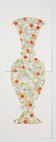
Artwork, other - Handcut & Collaged maps on paper, 'Survey Vessel I' by Carole Wilson, 2008
Carole WILSON (1960- ) Born Canberra, Australia Carole Wilson undertook undergraduate studies at the Canberra School of Arts and Phillip Institute of Technology. She completed a Graduate Diploma in Education at the University of Ballarat in 1987, and a Doctor of Philosophy in 2000. She has chosen central motifs in her work, which she incorporates throughout a series. The urn has been a unifying motif in Wilson's map work and testifies to the way in which function drives form across cultures. Carole's work is held in many public collections including the National Gallery of Australia, the Powerhouse Museum, State Library of Victoria and a number of regional Victorian galleries. Her posters are in museum collections in Finland, Moscow and Poland. In 2001 Dr Wilson was awarded a Doctor of Philosophy (Visual Art) from the University of Ballarat (Now Federation University). She graduated with a Graduate Diploma in Education from University of Ballarat in 1987, and a Diploma of Art from the Phillip Institute of Technology (RMIT) in 1984. Carole Wilson lectures at Federation University Australia: 2010- Senior Lecturer in Visual Arts, Honours and Research Degrees Co-ordinator 2009-2011 Lecturer in Studio Practice and Postgraduate Co-ordinator 1999-2008 Lecturer in Visual Arts (Sessional) This item is part of the Federation University Art Collection. The Art Collection features over 2000 works and was listed as a 'Ballarat Treasure' in 2007. Donated through the Australian Government's Cultural Gifts Program by Anne M. Drum, 2011art, artwork, carole wilson, maps, urn, alumni, available, staffmember -
 Federation University Art Collection
Work on paper - artwork, Susanna Castledon, 'Untitled' by Susanna Castledon
Susanna CASTLEDON (1968 - ) Born London, England Arrived Australia 1977 This item is part of the Federation University Art Collection. The Art Collection features over 2000 works and was listed as a 'Ballarat Treasure' in 2007.parallel prints, printmaking, map, susanna castledon -
 Federation University Art Collection
Print, 'Collagraph 3' by Carole Wilson, 2007
Carole WILSON (1960- ) Born Canberra, Australia Carole Wilson undertook undergraduate studies at the Canberra School of Arts and Phillip Institute of Technology. She completed a Graduate Diploma in Education at the University of Ballarat in 1987, and a Doctor of Philosophy in 2000. She has chosen central motifs in her work, which she incorporates throughout a series. The urn has been a unifying motif in Wilson's map work and testifies to the way in which function drives form across cultures. Carole's work is held in many public collections including the National Gallery of Australia, the Powerhouse Museum, State Library of Victoria and a number of regional Victorian galleries. Her posters are in museum collections in Finland, Moscow and Poland. In 2001 Dr Wilson was awarded a Doctor of Philosophy (Visual Art) from the University of Ballarat (Now Federation University). She graduated with a Graduate Diploma in Education from University of Ballarat in 1987, and a Diploma of Art from the Phillip Institute of Technology (RMIT) in 1984. Carole Wilson lectures at Federation University Australia: 2010- Senior Lecturer in Visual Arts, Honours and Research Degrees Co-ordinator 2009-2011 Lecturer in Studio Practice and Postgraduate Co-ordinator 1999-2008 Lecturer in Visual Arts (Sessional) This item is part of the Federation University Art Collection. The Art Collection features over 2000 works and was listed as a 'Ballarat Treasure' in 2007. Carole Wilson lectures at Federation University Australia: Framed collograph by Carole Wilson. art, artwork, wilson, carole wilson, available -
 Federation University Art Collection
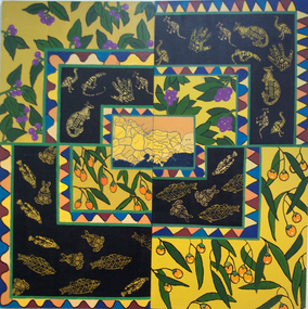
Painting - Artwork, [Untitled]
Under the direction of lecturer Raymond Thomas five students of Koorie Studies at the Gippsland Centre for Art and Design created this work. The were Vickie Turvey, Robyn Yates, Kellie Parsons, Melissa Fenton, Deanna Mobourne.A large canvas with indigenous plants, and Aboriginal animal motifs. If you can assist with information about this artwork, or the artist, please use the comment box below. artwork, artist, gippsland campus, aboriginal, kangaroo, emu, fish, clan map, vickie turvey, robyn yates, kellie parsons, melissa fenton, deanna mobourne, koorie studies -
Federation University Art Collection
Printmaking - Collograph, Fusea, Janine, The Map is in the Brain
This item is part of the Federation University Art Collection. The Art Collection features over 1000 works and was listed as a 'Ballarat Treasure' in 2007.art, artwork -
 Federation University Art Collection
Artwork, other - Artwork, 'Ghosts in the Himalayas (Shot Up)' by Lisa Anderson, 2016
Dr Lisa ANDERSON (1958- ) Dr Anderson’s research questions environmental issues that impact on the social structures of communities and their mapped or metaphysical borders. She develops projects around ways of understanding the effects of climate change. These include work with folklore, legends and religions that tell stories of coping with weather, forced migration of animals and people and coping with difference. She has undertaken international residency programs and exhibitions in the Arctic, Iceland, Paris, Norway, London and China, and she was the first Artist in Residence at the Australian Museum. These unique opportunities continue an extensive art practice of installation work, video, photography and sculpture. Anderson has an extensive record of exhibitions in Australia and overseas with work included in both private and corporate collections. Her exhibitions include Journeys: Due North, a large installation work that includes work created over a 10-year period of engagement in expedition and science work North of the Arctic Circle. Beneath the Beauty of Architecture, an exhibition at her London Gallery, Bicha, used images created in China, Nunuvut Territory in Canada and the Antarctic while working with the migration stories of survival. Dr Anderson has created many large scale artworks that challenge notions of occupation of the City, including Writing the City, a three-year program of installation works to shift the use of Sydney to being a city of public space in its pre-Olympic development. Singing up Stones celebrated the people who created and use the Opera House and the Quay for performance and ideas. This included the first image projection onto the Sydney Opera House, a projection onto the Sydney Harbour Bridge and a ballet of cruise liners with the sound simulcast on the local radio station. Two digital prints with acrylic on metal and bullet holes. This work is the result of research on the hidden voice of landscape undertaken by Dr Lisa Anderson while an Honorary Professor at Federation University Australia. lisa anderson, available -
 Stawell Historical Society Inc
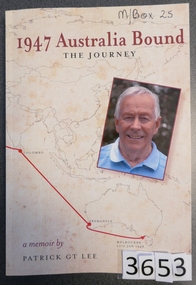
Book, Patrick G.T. Lee, 1947 Australia Bound - The Journey - Previously Cat No 3653, 2016
Chapter 7 relates to the family Life in Stawell Card Cover. Line drawn map showing the sea route from England to Melbourne, and a colour photo of the Author 1947 Australia Bound Thoe Journey A memoir by Patrick GT Lee Inside: To Jim Best Wishes Patstawell -
 Stawell Historical Society Inc
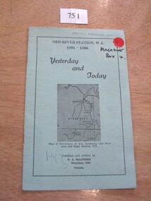
Book, N.A. McLennan, Yesterday and Today - Ord River Station WA 1895 - 1896 by N A McLennan, 1965
John McLennan's Period as Manager of the Ord River Station. W.A. adjoining Negri Station N.T., was 1895-6. The whole area consisted of 3,365,000 areas under a number of leasesand the then owner was Mr W.H. Osmand, who lived at "The Sycamores" four miles east of Stawell in Victoria. The Distance to Ord W.A. is 4,000 Miles.LIght green card cover with border, inside print and picture of a map Ord River Station W.A. 1895-1896 Yesterday and Today Map of North-East of W.A. Kimberly Ord River area Negri Station N.T. Complied and written by N.A. McLennan December 1965 1965 Victoriastawell, mclennan family -
 Stawell Historical Society Inc
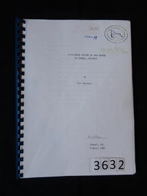
Book, R.B. Watchorn, A Pictorial History of Gold Mining at Stawell Victoria - Previously Cat No 3632, 06 April 1986
Photos and extracts from the proposed new pictorial history of gold mining in Stawell. PLEASE NOTE: This book is not very accurate, lots of mistakes.White Paper cover with map of Victoria inside two oval rings.A Pictorial History of Gold Mining at Stawell, Victoria By R.B. Watchorn R Watchorn (Signature) Stawell, Vic 6 April, 1986stawell -
 Stawell Historical Society Inc
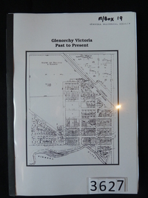
Book, Kevin Mitchell, Glenorchy Victoria, Past to Present - Previously Cat No 3627, 2010
A History of Glenorchy Included inside 10 A4 Pages of information about GlenorchyClear Plastic Cover over white paper with a map of Glenorchy, Blue tape spine and Black Card rear Cover. Glenorchy Victoria Past to Presentstawell -
Stawell Historical Society Inc
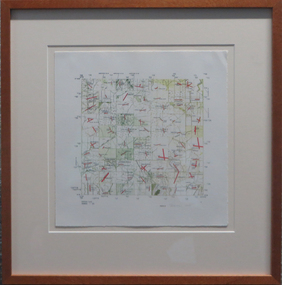
Map, P Jones, Shire of Stawell Roads and Reserves, 1989
... Two Copies (2) map With roads around Stawell. Forests.... Shire of Stawell Roads and Reserves Map P Jones ...Shows Woodlands Forests & Open WoodlandTwo Copies (2) map With roads around Stawell. Forests Woodlands 2 Very open Woodlands Coloured.Drawn P Jones. May 1989. Last Amended 25 may 1989 -
University of Melbourne, Burnley Campus Archives
Map - Topographic Survey, Ararat, 1970
Australia 1:100,000 Topographic Survey map of Ararat district, Victoria dated 1970. Sheet 7423 (Edition 1) Series R 652. Produced by the Royal Australian Survey Corps.royal australian survey corps, ararat area, stawell area -
 Stawell Historical Society Inc
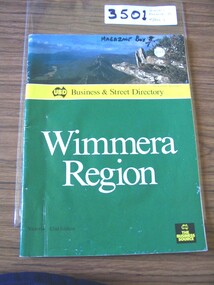
Book, UBD, UBD Business and Street Directory - Wimmera Region, 1992
... Region. as well as maps of Various Towns stawell Yellow section ...List of businesses with contact information in the Wimmera Region. as well as maps of Various TownsPaper cover with colour photograph of Boroka Lookout. below a yellow strip with black print and black representation of Australia. below green section with white and black print. black square in lower left with yellow printYellow section, In Map of Australia: UBD Business & Street Directory Green Section: Wimmera Region Victoria 42nd Edition In Black Square: UBD The Business Sourcestawell -
 Stawell Historical Society Inc
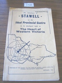
Book, Council of the Town of Stawell, The Advantages of Stawell as the Ideal Provincial Centre, 1966
Tan card cover with black border inside of which is a map of VictoriaThe Advantages of Stawell as the Ideal Provincial Centre to be developed right in the heart of Western Victoria. Prepared by the Council of the Town of Stawell Jointly with the Stawell Development Association September1966stawell tourism -
 Stawell Historical Society Inc
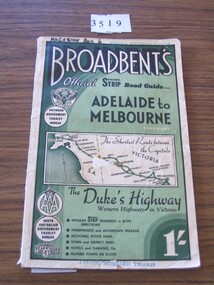
Book, Broadbent directory, Broadbent's Official : Speedo Strip Road Guide, 1943
Maps and descriptions of towns on the Western Highway & Dukes Highway from Melbourne to Adelaide. Sponsored by R.A.C.V and The Victorian Government Tourist BureauCream paper cover back border with green filling with a map from Melbourne to AdelaideBroadbeants Official Speedo Strip guide Melbourne to Adelaidestawell transport -
 Stawell Historical Society Inc
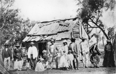
Photograph, Indigenous or First Nations People at Carrs Plains 1874
Photo taken at Carrs Plains in 1874 of Indigenous or First Nation People outside a wood and bark hut. In 1861, William Dennis of Carrs Plains Station, a staunch Methodist became Honorary, Aboriginal Protector for the area. One of his main tasks to give Government supplied food and clothing to the Aboriginals. Many district, remaining Aborigines became based at Carrs Plains, and their dead were buried in a cemetery on the station. The cemetery is show on survey map of Wirchilleva Borough, in corner of camping & water reserve near surveyed Bismarck township. In a Protector's report 1869, Dennis wrote that only one male worked regularly on the property, a Bullock driver.Black and white photograph of a wood and bark hut with a group of men, women and children out the front. Reproduction rights reserved Copied by State Library of Victoriastawell aboriginal portrait -
 Stawell Historical Society Inc
Photograph, Gold Fields Map Presentation to the Stawell Historical Society, 2001
... Gold Fields Map Presentation to the Stawell Historical...Gold Fields Map Presentation to SHS. Stawell Three (3 ...Gold Fields Map Presentation to SHS.Three (3) Colour Photographs 1: SHS President Betty Jackson presented with goldfields map. by goldfoelds manager, Richard Carlton. 2: Mayor Karen Douglas, with Betty Jackson and Richard Carlton 3: Mayor Karen Douglas presenting colouring competition to School childrenstawell -
 Stawell Historical Society Inc
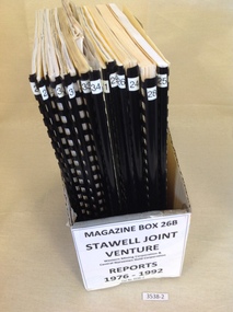
Book, Stawell Joint Venture, Stawell Joint Venture Reports 1976-1992, 1976-1992
Information on various aspects of the Stawell Gold Mine14 Yellow card with Black Plastic Ring Binders for spine. 3 Logos W.M.C. Central Norseman Limited Gold Corporation. Stawell Joint Venture. 2121: Western Mining Corporation Limited & Central Norseman Gold Corporation Limited. Progress report 1979 By R.B. Sloan. A Preliminary Look at the cost of establishing a Gold Production Operation at Stawell By N.R. Hook 1980 22: Western Mining Corporation Limited & Central Norseman Gold Corporation Limited. History of Exploration at Stawell By R.B. Watchorn & Stawell Development Proposal By R.B. Watchorn & N.R. Hooker 1980 23: Western Mining Corporation Limited & Stawell Joint Venture. Preliminary draft Stawell Gold Development Project A report on a proposed Exploration Drive. January 1981 24: Western Mining Corporation Limited & Stawell Joint Venture. Stawell Gold Development Project 1981 25: Western Mining Corporation Limited & Central Norseman Gold Corporation Limited. K Report No, 2595 Stawell Progress Report 1976-1981 26 Western Mining Corporation Limited & Central Norseman Gold Corporation Limited. K Reort No. 2630 Stawell report on teh Wonga Mining Area with recommendations for exploration. 1982 27 Western Mining Corporation Limited ( Incorporated in Victoria). Acting Manager And Agent for and on behalf of the Stawell Joint Venture between Western Mining Corporation Limited & Central Norseman Gold Corporation Limited 28: Western Mining Corporation Limited. Stawell Gold Project: A report on proposed Operations. 1983 29: Western Mining Corporation Limited & Central Norseman Gold Corporation Limited. K Report No. 2870 A report on the Newington - Three Jacks area with recommendations for Exploration 1984 30: Western Mining Corporation Limited & Central Norseman Gold Corporation Limited. Report K 2885 THe Geology, Ore reserves & Exploration Potential of the Wonga Area, Stawell 1984 31: Western Mining Corporation Limited & Stawell Joint Venture. Stawell Gold Project: Davis Open Cut Environment Effects Statement 1986 32: Western Mining Corporation Limited & Central Norseman Gold Corporation Limited. Report. The Stawell Goldfield History of Exploration and Development & Chronology of the Discovery, History & Development of the Stawell Gold Field. 33: Western Mining Corporation Limited & Central Norseman Gold Corporation Limited. K Report 3392 Stawell Exploration Joint Venture Progress report 1982-1991 1991 34: Western Mining Corporation Limited & Central Norseman Gold Corporation Limited. Three Fold out maps on the Treatment Plant. 1. Ball Mill Installation May 1989. 2. Vibrating Screen April 1992. By-Pass / Underflow / Oversize April 1992. 35Western Mining Corporation Limited & Central Norseman Gold Corporation Limited. Stawell - A renaissance. By S.H. Tan. 1986stawell gold mining -
Stawell Historical Society Inc
Map - Picture, Plan of Mining Leaseholders and of Land Applies for under Mining Lease November 1887. Plus photocopy, 1887
Lists Businesses in Stawell Trade Directory Mines Listed. New Darlington Mine, Moonlight Junction, Magdala Extended, Moonlight Consols, North Magdala Moonlight, Magdala No 1,Pioneer & Galatea, Pleasant Creek Cross Reef, Moonlight, Moonlight Extended, Oriental, Cross Reef Consolidated, Sloanes and Scotchmans, Scotchmans United, Scotchmans & Cross Reefs,, New Perthshire, Federal, Wimmera Wonga And Birmingham, Rutlands, Wonga ExtendedFramed Stawell Trade Directory 1887 and Plan of Mining Leaseholders and of Land Applies for under Mining Lease November 1887. Plus photocopy.W C Bates Mining Surveyor 4.11.87stawell -
Stawell Historical Society Inc
Map, Stawell Gold Mines, Stawell Township 1995, 1995
... of Mining Stawell Township 1995 Map Stawell Gold Mines ...Map shows details of mining activity Stockpiles, Tracks, Plant, Dams,, Waste, Tailing Dams, IronbarksPlain Printed Map in Black & White with details of MiningStawell Gold Mines Pty Ltdmining -
 Stawell Historical Society Inc
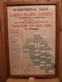
Memorabilia - Realia, 1905
Carr’s Plains Estate Subdivision Sale Poster with Subdivision Mapstawell -
Stawell Historical Society Inc
Map, Underground Survey of the Principal Mines of Stawell 1879, 1879
... Survey of the Principal Mines of Stawell 1879 Map ...Pleasant Creek & Newington, Prince Patrick, Prince Alfred, Pioneer and Galatea, Pleasant Creek Cross Reef No. 1&2, Magdala, Old Shaft, Extended Cross Reef, Crown Cross, Great Northern, Sloanes & Scotchmans, South Cross, 10 & 11 United Scotchmans South Cross, Scotchmans Shafts, North Scothmans, West Scotchmans, Emerald Isle & Rose of Denmark, Albion, South Scotchmans, Newington & Pleasant Creek, Pleasant Creek Cross Reef, Moonlight, Extended Cross Reef, Crown cross United, Great Northern ShaftVery large Map on cloth backing, showing cross sections of mines.Surveyed by H.C. Bates. Drawn by Arthur Edwards. October 30th 1879. Scales 120 feet to an inchmining, gold -
Stawell Historical Society Inc
Map, Plan View Township Area showing Known old workings 2003, 13 June 2003
Coloured Printing outline of lease of Gold Mine Horizontal Drives shown in BrownStawell Gold Mine. Scale 1:7500. Fri 13 June 2003mining -
Stawell Historical Society Inc
Book - Family History, Jennie McKenzie, Our Kelly Connection -1837-2007 - Links to the Past, 2008
Mentions Stawell on different Pages. Compiled by Jennie McKenzie Printer: Mallee Printers Pty Ltd 2007 141 Best Street Sea Lake, Victoria, AustraliaBlue background - part map in darker blue. Oval Sepia photo of a man with moustache and beard, outline of a woman holding a baby with 2 children.Presented to Stawell Biarri Group for Genealogy by Michael Davey 28 May