Showing 1011 items matching "storm"
-
 Ballarat Tramway Museum
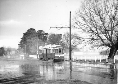
Photograph - Black & White Photograph/s set of 2, Charles Craig, 21/08/1971 12:00:00 AM
Yields information about tram operations in Wendouree Parade prior to closure following a big rain storm.Set of two black and white photographs of trams in Wendouree Parade after the big rain / hail storm on Friday 21/8/1971 .1 - No. 41 at the intersection with St Aidans Drive and Wendouree Parade, Tram has two Johnnie Walker roof advertisements .2 - No. 12 in Wendouree Parade, near Haddon St with destination of Gardens via Drummond North with a tram stop shelter in the background. Tram has a Twin Lakes sign. Photo by Charles Craig, at the time of the first closure of the Ballarat system, 23/8/1971 when the Victoria St line closed.trams, tramways, wendouree parade, haddon st, shelters, st aidans drive, closure, tram 41, tram 12 -
 Victorian Interpretive Projects Inc.
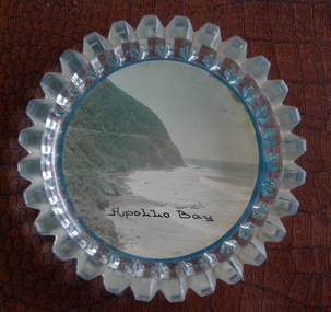
Image of souvenir ware, Apollo Bay
Apollo Bay is located between Wye River and Cape Otway on Victoria's scenic coastal route, the Great Ocean Road. In the 1840s the Henty brothers established a whaling station at Point Bunbury on the western end of the bay. The bay was named by Captain Loutit in 1845 when he sheltered his vessel, the Apollo during a storm. (http://en.wikipedia.org/wiki/Apollo_Bay)A coloured picture of a coastline attached to a glass butter plate. The coastline is Cape Patton, Apollo Bay, Victoria"Apollo Bay"apollo bay, beach, coast, souvenir -
 Kew Historical Society Inc
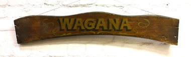
Sign, Wagana, 1920s
In the 1920s and 30s, rowing on the Yarra was a very popular weekend pastime. Each of the early boats was individually named in gold letters on its varnished wooden backboard. This is all that remains of one of the Thames pulling boats from Burns' Boatshed at Studley Park which was destroyed by a falling tree in a storm. Their entire fleet of rowing boats has now been replaced by fiberglass boats.Varnished wooden backplate of a rowing boat. The shaped sign is embossed with the name 'Wagana" in gold lettering, outlined and shaded in black paint. Gilt scroll work surrounds the name. The ends of the backplate shows the holes where the plate was once attached to the seat of the boat. The name Wagana means 'to dance' in Wiradjuri language."Wagana"burns' boatshed, thames pulling boats, yarra river -- kew (vic.), boathouses - river yarra -
 Bendigo Historical Society Inc.
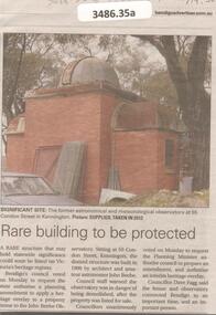
Newspaper - Articles on the former Observatory, 2024
The City of Bendigo asked for a heritage overlay over the site of a private Kennington observatory. It was once used for for the City's official meteorological readings. The observatory was built by architect John Beebe and is on the storm damaged property part of "La Rocca" house. Council approved $2 million for preservation of the site which will be integrated into a contempory complex boasting seven childcare rooms for 144 children.Bendigo Advertiser and the Herald sun: five articles on the former astronomical observatory at 55 Condon Street in Kennington.bendigo, observatory, john beebe -
 Dandenong/Cranbourne RSL Sub Branch
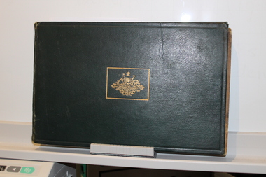
Large Book, "The Changing of the Guard"
Large Green Leather covered book with Gold Australian Coat of Arms on front.Reproduced from Official and other photographs of the two World Wars. Published under the auspices of the Board of Management of the Australian War Memorial. Contains Dedication - To the men and women of the Empire who in every hour of danger , face the storm … who in their willing sacrifice are bearing the brunt of a struggle for the peace and security of all peoples. Faint stamp "Maurice Parker" inside front cover top left. -
 City of Moorabbin Historical Society (Operating the Box Cottage Museum)
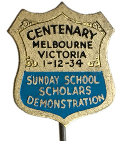
Badge - Sunday School Scholars Demonstration Pin, 1934
The Sunday School Scholars Anniversary Celebration was to be held on 1 December 1934, but due to an abnormal storm on the day before it was postponed to 8th December 1934. 15000 Sunday school scholars and teachers marched through the streets of Melbourne to demonstrate the strength of youth organisations associated with the Churches. The march ended at the Treasury Gardens where a thanksgiving service was held, more than 35,000 people attended. Some of the families of the City of Moorrabbin would have attended this march.Silver pin in the shape of a shieldCentenary Melbourne Victoria 1-12-34 - Sunday School Scholars Demonstrationsunday school, religion, melbourne, treasury gardens -
 Bayside Gallery - Bayside City Council Art & Heritage Collection
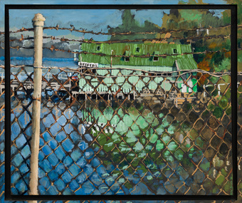
Painting - acrylic on canvas, Mike Green, Keefers, 1976
In the early 1900s, Melbourne builder Charles Keefer was hired by the Moorabbin Council to build the municipal baths at Beaumaris. In 1903, Keefer took over the Beaumaris Boat House and enlarged it to form Keefer's Boat Shed where day trippers and holiday makers could hire boats and venture out into the bay. Although rebuilt following the devastating storms in 1934, Keefer’s Boat Shed was completely destroyed by fire in 1984.Realismkeefer's, boatshed, bayside, coast, beaumaris, fence, water, bay, charles keefer, pier, mike green -
 Lara RSL Sub Branch
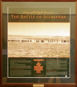
Photograph, Battle of Beersheba - Limited Edition of 1917, Rememberance Day 2008
The battle of Beersheba took place on 31 October 1917 as part of the wider British offensive collectively known as the third Battle of Gaza. The final phase of this all day battle was the famous mounted charge of the 4th Light Horse Brigade. Commencing at dusk, members of the brigade stormed through the Turkish defences and seized the strategic town of Beersheba. The capture of Beersheba enabled British Empire forces to break the Ottoman line near Gaza on 7 November and advance into Palestine.Decisive victory at Beersheba fell to one of the last great charges of mounted troops in history. As Australian Light Horse Divisions captured the town and secured crucial water wells, their success also marked the beginning of the end of the war in the Middle East. This end came exactly a year to the day after success at Beersheba.Rectangular shaped glass covered picture frame showing the Light Horsemen.Charge of the Light Horsemen The Battle of Beershebabeersheba, the light horse, lara r.s.l.,world war one, battle of beersheba, ww1 -
 Eltham District Historical Society Inc
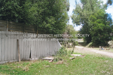
Photograph, Fay Bridge, Flood damage at Nillumbik Medical Centre, 1078 Main Road, Eltham, 26 December 2011
Flood damage resulting from a late afternoon storm on Christmas Day 2011. A flash flood occurred from significant rain fall and hail, which accumulated along an old waterway with floodwater submerging cars along Valonia Drive then down Grove Street flooding houses, through the Bible Street Reserve where it then submerged Main Road washing away the small railway trestle bridge opposite the reserve then flooding the Judge Book Village before finally entering the Diamond Creek..fay bridge collection, 2011-12-26, bible street reserve, flood damage, floods, floodwater, main road, nillumbik medical centre -
 Ballarat Tramway Museum
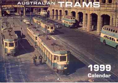
Document - Calendar, Topmill Pty Ltd, "Australian Trams - 1999 Calendar", 1998
Yields information about tramway operations post WW2 throughout Australia tramway cities.Wall Calendar - heavy card covers, 12 gloss art pages inside, titled "Australian Trams - 1999 Calendar" containing cull colour photographs of Sydney, Brisbane, Adelaide, Perth, Bendigo, Ballarat, Hobart, Melbourne, and a list of Australian and New Zealand tramway museums. Ballarat featured in June, 33 in the depot yard during a hail storm - 20/8/1971 - photographer not given. Has a punched hole along the top edge to enable wall use. Provides dates for holidays, school holidays and Pension payment days and phases of the moon. Produced by Topmill Pty Ltd and distributed by Gordon & Gotch Pty Ltd. Photos by Hugh Ballment, Dale Budd, Robert Merchant, Arthur Perry and Sydney Tramway Museum.tramways, trams, ballarat, bendigo, melbourne, adelaide, hobart, brisbane, sydney -
 Bendigo Historical Society Inc.
Book - HELEN MACPHERSON SMITH TRUST ANNUAL REPORT 2007
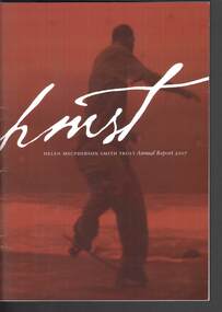
Forty-four page dark red covered report with a red shaded photo/drawing of a young man on a skateboard, titled Storm Sequence (2000) by Shaun Gladwell. In the front of the book is a loose letter mentioning the 2007 annual Report, covering their activities of the Trust for the year. Titles in the book are: About Our Founder and Her Legacy; Trustee's Report; Grants Overview; Grants Approved in 2006-2007, which are Aged Care, Arts, Culture & Heritage; Community Support; Disability Care & Support; Education; Employment & Vocational Training; Environment; and Health; Investments and Grants - An historical perspective, Financial Summary and An Historical Insight: The Smiths in Australia. Most chapters have information.Helen Mcpherson Smith Trust Annual report 2007helen macpherson smith trust annual report 2007, helen macpherson schutt (nee smith), darvell m hutchinson am, j barry hutchins oam, frances h awcock am, keith b smith, anthony baird, darren mcconnell, liz gillies, sarah bartak, pamela beech, lonia catalano, beolite village, bundji bundji, odyssey house victoria, macpherson smith community alliance, brotherhood of st laurence, dolphin research institute, howard florey institute, the jean hailes foundation for women's health, historical insight - the smiths in australia, shaun gladwell -
 Eltham District Historical Society Inc
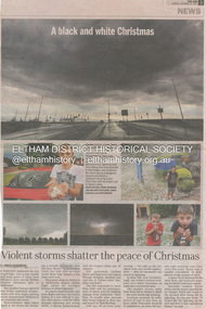
Newsclipping, Vince Chadwick, Violent storms shatter the peace of Christmas, The Age, Monday, December 26, p3, 2011
A late afternoon storm on Christmas Day 2011. A flash flood occurred from significant rain fall and hail, which accumulated along an old waterway with floodwater submerging cars along Valonia Drive then down Grove Street flooding houses, through the Bible Street Reserve where it then submerged Main Road washing away the small railway trestle bridge opposite the reserve then flooding the Judge Book Village before finally entering the Diamond Creek. Widespread damage occured from hail and flash flooding.fay bridge collection, 2011-12-26, eltham, flood damage, floods, grove street, main road, valonia drive -
 Eltham District Historical Society Inc
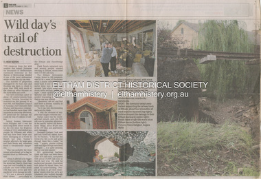
Newsclipping, Reid Sexton, Wild day's trail of destruction, The Age, Tuesday, December 27, pp4-5, 2011
A late afternoon storm on Christmas Day 2011. A flash flood occurred from significant rain fall and hail, which accumulated along an old waterway with floodwater submerging cars along Valonia Drive then down Grove Street flooding houses, through the Bible Street Reserve where it then submerged Main Road washing away the small railway trestle bridge opposite the reserve then flooding the Judge Book Village before finally entering the Diamond Creek. Widespread damage occured from hail and flash flooding.fay bridge collection, eltham, 2011-12-27, flood damage, floods, floodwater -
 Eltham District Historical Society Inc
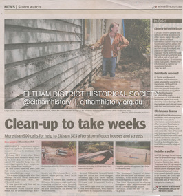
Newsclipping, Shaun Campbell, Clean-up to take weeks, Diamond Valley Leader, December 2011
A late afternoon storm on Christmas Day 2011. A flash flood occurred from significant rain fall and hail, which accumulated along an old waterway with floodwater submerging cars along Valonia Drive then down Grove Street flooding houses, through the Bible Street Reserve where it then submerged Main Road washing away the small railway trestle bridge opposite the reserve then flooding the Judge Book Village before finally entering the Diamond Creek. Widespread damage occured from hail and flash flooding.fay bridge collection, eltham, flood damage, floods, floodwater -
 Eltham District Historical Society Inc
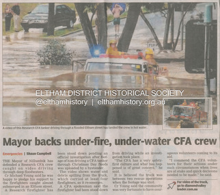
Newsclipping, Shaun Campbell, Mayor backs under-fire, under-water CFA crew, Diamond Valley Leader, December 2011
A late afternoon storm on Christmas Day 2011. A flash flood occurred from significant rain fall and hail, which accumulated along an old waterway with floodwater submerging cars along Valonia Drive then down Grove Street flooding houses, through the Bible Street Reserve where it then submerged Main Road washing away the small railway trestle bridge opposite the reserve then flooding the Judge Book Village before finally entering the Diamond Creek. Widespread damage occured from hail and flash flooding.fay bridge collection, eltham, flood damage, floods, floodwater, main road, research fire brigade -
 Lara RSL Sub Branch
Statement By Eric George Elliott on the Light Horse Brigade charge at Beersheba
This statement by Eric George Elliott tells how The battle of Beersheba took place on 31 October 1917 as part of the wider British offensive collectively known as the third Battle of Gaza. The final phase of this all day battle was the famous mounted charge of the 4th Light Horse Brigade. Commencing at dusk, members of the brigade stormed through the Turkish defences and seized the strategic town of Beersheba. The capture of Beersheba enabled British Empire forces to break the Ottoman line near Gaza on 7 November and advance into Palestine.Decisive victory at Beersheba fell to one of the last great charges of mounted troops in history. As Australian Light Horse Divisions captured the town and secured crucial water wells, their success also marked the beginning of the end of the war in the Middle East. This end came exactly a year to the day after success at Beersheba.Rectangular shaped glass covered picture frame with a photocopy of his statement on the charge of Beersheba.ww!, beersheba, statement, photocopy, australian light horse brigade. -
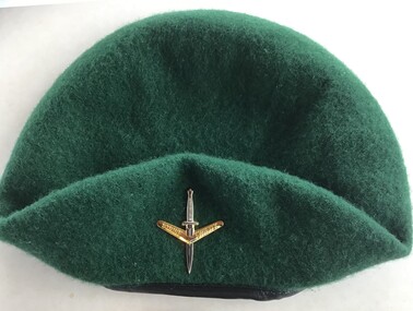 Queenscliffe Maritime Museum
Uniform - Beret
On the evening of February 17, 1960, 74 peacetime commandos in army boats set off on a training exercise from Point Lonsdale to Point Nepean, simulating a raid. The weather was calm at Point Lonsdale on a midweek evening 50 years ago, but 50 years ago weather forecasts were not yet reliable. By nightfall a massive storm came through and all hell broke loose. Soon, three young Victorians were dead and more than 70 others were rescued from huge seas in Bass Strait.Green commando beret similar to ones worn by commandos involved in Rip Disaster of 1960Commando beret (green) with unit insigniaUnit insignia: "Strike Swiftly"commandos, beret -
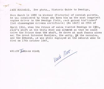 Bendigo Historical Society Inc.
Document - VARIOUS ARTICLES FOR NEWSLETTER ('MARUNARI?) FOR NOVEMBER
Various articles for Newsletter ('Marunari??) for November???? 1. Re Jack Moorhead (''the most competent engine driver in the Bendigo field'') with handwritten copy of same; 2. 3 pages of handwritten notes for inclusion in the newsletter - various topics; 3. ''The Canons (sic) on Camp Hill'' - history of the Lookout Tower site and flag post, cannons and statue - semi-nude lady - which was damaged in storm and later removed. Source of information for this item attributed to Misses D and D Davenpor, London and the Bendigo Advertiser; handwritten notes re this same article. 4. ''Boys will be boys'' by Mr A Richardson - article based on Annual Report of the Secretary for Mines and Water Supply, 1885 re 11 year old lad who fell down mine; handwritten notes on same article.document, names of bendigo pioneers, jack moorhead. -
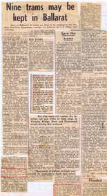 Ballarat Tramway Museum
Newspaper, The Courier Ballarat, "Nine trams may be kept in Ballarat", Aug. 1971
Yields information about the closure of the SEC operated Ballarat system - presented in an unorganised manner and without newspaper dates.Set of about 5 newspaper clippings glued to a sheet of lined paper. Main cutting titled "Nine trams may be kept in Ballarat", from The Courier Ballarat, 18/8/1971 (can read date through the back paper), about the number of trams to be kept in Ballarat, the BTPS, removal of the overhead. Other cuttings note the provision of bus stops in Ballarat, a hail storm the previous day (Friday 17/8/2005), floods, the derailment of a tram while on a tour for the Ballarat North Technical School, employment of those employees who had been retrenched and two letters re the replacement of the trams, including the aims of the BTPS to operate in Wendouree Parade. Letter re the BTPS signed by John Anderson. See also Reg item 3165 and 6665 for similar presentations of cuttings.secv, closure, employment, btps, disposal, storms -
 Glenelg Shire Council Cultural Collection
Functional object - Lifeboat Wreckage, Coramba Lifeboat piece, 1911
Possibly from the Kurtze collection The 531 ton coastal steamer, the S.S.Coramba, was built in Scotland in 1911 and was lost at sea off Phillip Island on November 30, 1934, during a violent storm. There were no survivors. This starboard lifeboat from the Coramba was found washed up on the southern shores of Phillip Island on November 30, 1934, and was thought to have held two crew members, whose bodies were later found near Forrest Caves. This piece of lifeboat was found among the wreckage on Phillip Island shortly after the vessel sunk in 1934.A section of wreckage from the lifeboat 'Coramba'. This section has been cut from the wreckage. 4 sections of planking. Lapstake construction painted white with the lettered name 'CORAMBA' in black.Front: 'CORAMBA' 'S1' Back: -sscoramba, lifeboat, wreckage, phillip island, kurtze museum -
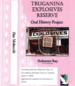 Truganina Explosives Reserve Preservation Society Inc (TERPS)
Digitised Oral History – Truganina Explosives Reserve - Tape 5 Jim Melmoth, 2018
The interviews were recorded in 2000 by Bronwen Gray and Alan Young for the production of Unreserved, Stories from Truganina Explosives Reserve, animated stories from past residents, workers and interested people of the Reserve (subject to copyright 2004). Edgar James (Jim) Melmoth began work at the Truganina Explosives Reserve at age 19 (1952) as part of the maintenance crew – painting, tram line maintenance, storm damage clearance. He helped build the pier extension and the water tower. In this interview he describes some incidents and some amusing stories of the clysdale horses. A primary source of information on memories of the Truganina Explosives Reserve and Altona,VictoriaDigital copy of original cassette recorded in 2000 and digitised in 2018hobsons bay city council, explosives, air raid shelters, altona pier, brown coal, camouflaged fences, world war two, gelignite, horse drawn wagons, clysdale horses, lighters, williamstown, upton street altona, water tower, adze, john gates, public works department, explosives pier, cherry lake, altona, altona meadows, lennie finley -
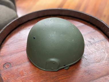 The 5th/6th Battalion Royal Victoria Regiment Historical Collection
Headwear - Helmet, British Army Helmet Mk6
The Mk 6 was issued to the British military in 1986.[3] They were known to be used in Operation Desert Storm and Desert Shield.[4] From 1992, the Mk 6 was supplied to the UN alongside the M88, MICH and the M1 to allow for protection of peacekeeping forces. Many military forces used these helmets such as Argentina, Mexico, and most listed UN countries as stated. These were either covered with the respective country's camouflage helmet cover, or issued with a blue Mk 6 cover to indicate it as a peacekeeping helmet.[5] From June 2009, the helmet was replaced by the Mk 7 helmet.British Army combat helmet mk 6 made of ballistic nylon, painted olive green. It has a foam and leather liner and an olve green webbing harness to secure the helmet to the soldiers head. "Becca" is written in sharpie on the inside rear right of the helmet forward of the manufactures sizing and serial tag. -
Queenscliffe Maritime Museum
Equipment - Engine room telegraph
Court of Marine Inquiry found that steering gear had failed as vessel entered Heads. Fault lay with Lloyd's surveyor for not detecting fault. Vessel had been classified Al. No blame attachable to master. Two Queenscliff fishermen purchased wreck for 950 pounds (insured value 30,000 pounds)and its timber cargo - handsome profit. Cargo and most fittings of value recovered. Wreck visible until early 1960s, until during a storm it slid off northern side of Nepean reef and broke up in 20 feet of water. The most noteworthy shipwreck to date at the heads.Ship's engine room telegraph from bridge of SS TimeChadburns ship's telegraph manufacturersss time, wrecks, marine telegraph -
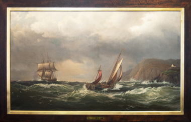 Mission to Seafarers Victoria
Painting - Oil painting, Madeline M.Ravenna Lewellin, Start Point Light, Devonshire, 1875
This painting was inspired by an original painting by Wilhelm Melby held at the National Gallery of Victoria. Melby is a Danish artist (1824-1882). It depicts a famous Devonshire coastal region famous now for its lighthouse and the pick up point for the pilot when entering waters approaching Dartmouth. The sailing vessels pre-date the construction of the famous lighthouse. Over the centuries the view would have been familiar to many sailors as they left or approached the English mainland and south coast ports in the English Channel. Madeline Mary Ravenna Lewellin (1854 – 24 November 1944) was born in Victoria to Dr John Henry Hill Lewellin, a physician, and Grace Elizabeth (née Danneby). She was one of five daughters, and the family lived in Prahran. Lewellin's brother, Captain Herbert Gordon Hill Lewellin, was a commander in the P. and O. fleet (apprentice on the Romanoff, Lieutenant RNR on the HMS Arethusa in 1899, RMS Mongolia in 1913 sunk in 1917, Naldera in 1920). She studied painting at the National Gallery School in 1879 under Eugene von Guerard. She's also known for collecting and painting specimens, and became a member of the Field Naturalists Club of Victoria in 1885. In 1884 she won a silver medal for her studies of fungi. She collected plants for Australian botanist Ferdinand von Mueller, and the variety of Dicrastylis lewellinii (Purple sand-sage) is named after her. Miss Lewellin, who had a love of the sea and ships as subject matter is listed in 1910 as a donor as a 10/6 member donating to the motor launch fund and in 1918 as a working member of the Ladies Harbour Lights Guild which involved regular volunteer shifts at the Mission to Seamen on canteen and other duties.Marine art, Maritime artThis oil painting has a dark polished wood and gold leaf slip. The painting depicts two masted boats. The choppy sea takes up the lower-third of the painting, and the other two-thirds of the image of made up of stormy grey clouds. A rocky cliff face can be seen on the right-hand side of the painting. A small church can be seen on the hillside. The ship on the left third of the painting sits on the horizon line of the sea. The centre ship with two masts appears to be leaning to the right and its deck is exposed to the viewer showing four men attempting to handle the masts and rigging. The left-hand ship with three masts is surrounded by two grey distant silhouetted mast ships. There are three seagulls at the upper left-centre of the image. There are another three gulls down on the lower-left of the image. Front: ENGRAVED PLAQUE: Start Point Light. Devonshire. SIGNATURE: After W. Melby / M.M.R Lewellin. 1875. Reverse: IN BLACK MARKER PEN: * Hang from two points * WHITE STICKER WITH CONSERVATOR DETAILS: Art Conservation Frames / 118 Bridport Street, Albert Park, VIC, 3206 / 9696 9066 / artconservationframers.com.aupainting, ships, mast, church, sea, storm, oil painting, seagulls, madeline r. lewellin, artwork-paintings, ngv, wilhelm melby, eugene von guerard, botanist, rms mongolia, captain herbert gordon hill lewellin (1862-1935), paddy lewellin, reproduction -
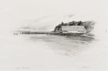 Bayside Gallery - Bayside City Council Art & Heritage Collection
Work on paper - ink and watercolour, Annette Meikle, Keefer's boat shed, 1977
In 1977, artist Annette Meikle undertook a commission to illustrate a book recording stories of places and people in the Bayside area. It was published in 1978 as Sandringham Sketchbook, with text by Elizabeth Waters. The sketches were intended to record remaining examples of Bayside’s early architecture and environment, as well as reflect newer architectural changes. Meikle went on to donate 22 of these sketches to Bayside City Council in 2003. Charles Keefer established this landmark boat hire business in the early twentieth century, shortly after he had built municipal baths at Beaumaris. The original boat shed was damaged in a storm in 1934 and burned down in 1984.Annette Meikle, Keefer's boat shed 1977, ink and watercolour, 33 x 53.5 cm. Bayside City Council Art and Heritage Collection. Donated by the artist, 2003annette meikle, sandringham sketchbook, elizabeth waters, port phillip bay, coastline, beaumaris, keefer's, keefer's boat shed, jetty, boat shed -
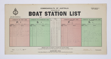 Queenscliffe Maritime Museum
Document - Form, Boat Station List
The Court of Marine Inquiry found that the steering gear had failed as the SS Time entered Port Phillip Heads. It was established that the fault lay with the Lloyd's surveyor for not detecting the fault when the Time had been classified Al. No blame was attached to the master. Two Queenscliff fishermen purchased weck for 950 pounds (insured value 30,000 pounds)and its timber cargo - handsome profit. Cargo and most fittings of value recovered. Wreck visible until early 1960s, until during a storm it slid off northern side of Nepean reef and broke up in 20 feet of water. The most noteworthy shipwreck to date at the heads.Two Queenscliff fishermen purchased the weck for 950 pounds (insured value 30,000 pounds) and its timber cargo - handsome profit. The cargo and most of the fittings of value were recovered. The wreck was visible until the early 1960s, until during a storm, it slid off the northern side of Nepean Reef and broke up in 20 feet of water. The most noteworthy shipwreck to date at the heads.A Commonwealth of Australia Navigation Act, Boat Station List form, showing the names of crew assigned to each of 4 lifeboats on the Port [P] and Starboard [S] sides of the SS Time dated 1 August 1949.Form C.B.D.F 3 for 4 lifeboats; Boat Station List navigation act, ss time, port phillip, shipwrecks, lifeboat rules -
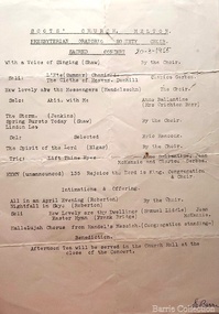 Melton City Libraries
Document, Scots' Church Choir, 1955, 1937
In March 1955 the Presbyterian Oratorio Society Choir held a Sacred Concert including with solo performances from Clarice Gerber, Anne Ballantine (Mrs Creighton Barr) and Eric Hancock. The choir performed the following pieces; With a Voice a Singing (Shaw) How lovely are the Messengers (Mendelssohn) The Storm (Jenkins) Spring Bursts Today (Shaw) Linden Lea The Spirit of the Lord (Elgar) Hymn 135 Rejoice the Lord is King. Choir and Congregation All in the April Evening (Roberton) Nightfall in Skye Hallelujah Chorus from Handel’s Messiah (Congregation Standing) From Scots’ Presbyterian Church Melton-Edna Myers Barrie musical contributionsEdna Barrie's copy of the Presbyterian Oratorio Society Choir schedule and Edgar Barrie's copy of a balance sheet churches -
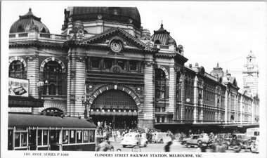 Melbourne Tram Museum
Postcard, Rose Stereograph Co, "Flinders Street Railway Station, Melbourne", early 1940s
Rose Series postcard No. P 1040, titled "Flinders Street Railway Station, Melbourne" showing the entrance to the station, many motor cars, some with black-out headlight covers, a MMTB Leyland bus, and a W2 class tram either 288 or 388 (Kew Depot cars at the time.) with the destination of Spencer St. This would have to be one of the first W2 class cars to have the metal gutter replaced by a storm/drip rail. There is an advertising board on the railway station verandah, advertising Liberty Loans. You can just make out the tram overhead for the curve from Swanston Street into Flinders Street.Yields information about Flinders Street and railway station in the early 1940s.Postcard - printed real photograph with Rose Stereograph Co. name on the rear.tramways, trams, flinders st, flinders st station, w2 class, buses, mmtb buses, world war ii -
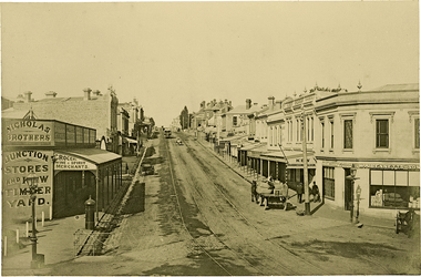 Kew Historical Society Inc
Photograph, J F C Farquhar, High Street, Kew, 1891
At the beginning of the 1890s, the Kew businessman and Town Councillor, Henry Kellett, commissioned J.F.C. Farquhar to photograph scenes of Kew. These scenes included panoramas as well as pastoral scenes. The resulting set of twelve photographs was assembled in an album, Kew Where We Live, from which customers could select images for purchase.The preamble to the album describes that the photographs used the ‘argentic bromide’ process, now more commonly known as the gelatine silver process. This form of dry plate photography allowed for the negatives to be kept for weeks before processing, hence its value in landscape photography. The resulting images were considered to be finely grained and everlasting. Evidence of the success of Henry Kellett’s venture can be seen today, in that some of the photographs are held in national collections.It is believed that the Kew Historical Society’s copy of the Kellett album is unique and that the photographs in the book were the first copies taken from the original plates. It is the first and most important series of images produced about Kew. The individual images have proved essential in identifying buildings and places of heritage value in the district.In 1891, High Street was the centre of commercial activity in the Borough of Kew. It was unpaved and edged with deep bluestone gutters, which were designed to channel the significant flow of storm water down the hill to and beyond the Junction. On either side of the entrance to the shopping strip are two cast iron gas lamps that provided the only public street lighting before the Post Office was reached. Most shops, including the Nicholas Brothers’ Junction Store featured cast iron verandas. Further up the hill, Dougherty’s Greyhound Hotel was by this stage a local institution. Apart from the horse-drawn tram, the main form of personal and commercial transport in this period remained the horse, horse and cart, or buggy.The panoramic view predates the widening of High Street in the 20th century, and thus includes the original alignment of buildings on the south side. These included Henry Kellett’s shop.High Street, Kewkew illustrated, kew where we live, photographic books, henry kellett, high street - kew (vic) -
Mission to Seafarers Victoria
Letter - Correspondence, 1/12/1950
Allan writes of being in Gothenburg the day after the Swedish King died (November 1950).Quinn CollectionA three-page letter written in green ink on three pages of buff coloured unlined paper (0851.a1-3) headed M.S.Mongabarra, Norrkoping, Sweden and dated 1/12/50. The pale blue envelope (0851.b) is addressed to Mrs K Hayes, 14 Fitzroy Street, St Kilda, Victoria. There are 9 red stamps, valued at 20 Norwegian Krona each, and one green stamp, valued at 10 N.Krona, across the top of the envelope. There are three postmarks.In this letter to his mother Allan describes how beautiful it was sailing into Norrkoping with everything covered with just a little snow but after a snow-storm the next day the ropes were frozen and the tarpaulins were like sheets of iron. The ship is half full of timber for Australia and will arrive in Adelaide in late January 1951 but he won't be on it as he is handing in his book and will sign off in Gothenburg on the 11th December. He plans to spend Christmas in Oslo before travelling to London. He anticipates being back in Australia for good in the middle of 1951. letters-from-abroad, allan quinn, m s mongabarra, antwerp, gothenburg, norrkoping, sweden