Showing 285070 items
matching streets,roads,melbourne,map,melway
-
 Montmorency–Eltham RSL Sub Branch
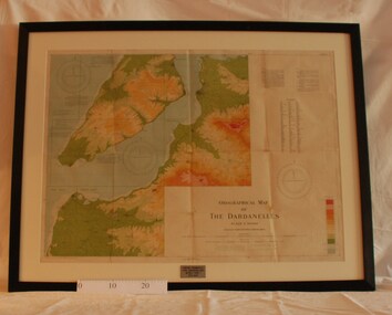
Map - Framed 1915 Map of Krithia, Gallipoli, 1915 Map of Krithia, Gallipolli, 1915
A framed topographical map of The Dardenelles produced from captured Turkish maps by the Egyptian Survey Department. The main feature is the Krithia battlefield area in 1915.Krithia Peninsula (The Dardenelles) World War One - 1915 Mapworld war one, 1915, egypt, map, dardenelles, krithia, survey department, turkey, battlefields -
 Whitehorse Historical Society Inc.
Document, F. S. Baker/ Yarra Hill country map, 1950s
Advertising leaflet for F. S. Baker, Mt. Pleasant Road Nunawading,Advertising leaflet for F. S. Baker, Mt. Pleasant Road Nunawading, Real Estate Agent c. 1950s, backed by Broadbent's Map no. 280, Yarra Hill CountryAdvertising leaflet for F. S. Baker, Mt. Pleasant Road Nunawading, broadbents, baker, f. s., mount pleasant road, nunawading, no. 20 -
 Port Melbourne Historical & Preservation Society
Document, Hotels in Port Melbourne
The letter on the outside of the sheet is from Jim (?) to Les (Turner). It gives some of his childhood recollections of Port Melbourne Hotels These include the Shamrock which he understood that it was "... a weatherboard Building - very Badly Conducted and when it was burned down it was not rebuilt... I did know that there was a murder there."Inside is hand drawn map of Port Melbourne with the hotels marked in position as well as a Key down the left hand side. The accompanying typed sheet lists the 50 original hotels on the left hand side and the 20 remaining on the right.A large ruled sheet of paper with a letter on the outside & inside a hand drawn map of Port Melbourne with the location of hotels marked. A typed sheet lists the hotels.Hotels of Port Melbourne. Originally there were 50. today there are 20.business and traders - hotels, shamrock hotel, leslie stanley turner -
Tatura Irrigation & Wartime Camps Museum
Booklet, The Streets and Parks of Mooroopna, 1999
... The Streets and Parks of Mooroopna ...Produced to ensure accurate recording of information re town of Mooroopna. Maps and street names and parkland included. Dedicated to the memory of the Late Jean Anselmi (1916-1998)Green card cover with photograph of McLennan (Main) Street of Mooroopna early1900's.mooroopna victoria, mooroopna streets, mooroopna parklands, jean anselmi -
 Whitehorse Historical Society Inc.
Document - Map, Roads, 1932
... Roads ...Map of roads on which Country Roads Board funds were spent, with request and response by Shire of Blackburn and Mitcham to the Country Roads Board, July - August 1932.roads and streets, victoria. country roads board, shire of blackburn and mitcham, terrara road, vermont -
 Greensborough Historical Society
Map, U. M. Woods, Map of Greensborough early to mid 1950s, 1839-1959
Map of Main and Grimshaw Streets Greensborough by U.M. Woods. Properties shown are drawn from memory and represent the town in the early to late 1950s.Sketch map, black on white paper. letter of explanation.u. m. woods, grimshaw street greensborough -
 Kew Historical Society Inc
Plan, Melbourne & Metropolitan Board of Works : Borough of Kew : Detail Plan No.1291, 1905
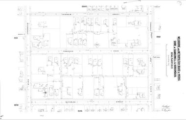
The Melbourne and Metropolitan Board of Works (MMBW) plans were produced from the 1890s to the 1950s. They were crucial to the design and development of Melbourne's sewerage and drainage system. The plans, at a scale of 40 feet to 1 inch (1:480), provide a detailed historical record of Melbourne streetscapes and environmental features. Each plan covers one or two street blocks (roughly six streets), showing details of buildings, including garden layouts and ownership boundaries, and features such as laneways, drains, bridges, parks, municipal boundaries and other prominent landmarks as they existed at the time each plan was produced. (Source: State Library of Victoria). This plan forms part of a large group of MMBW plans and maps that was donated to the Society by the Mr Poulter, City Engineer of the City of Kew in 1989. Within this collection, thirty-five hand-coloured plans, backed with linen, are of statewide significance as they include annotations that provide details of construction materials used in buildings in the first decade of the 20th century as well as additional information about land ownership and usage. The copies in the Public Record Office Victoria and the State Library of Victoria are monochrome versions which do not denote building materials so that the maps in this collection are invaluable and unique tools for researchers and heritage consultants. A number of the plans are not held in the collection of the State Library of Victoria so they have the additional attribute of rarity.Original survey plan, issued by the MMBW to a contractor with responsibility for constructing sewers in the area identified on the plan within the Borough of Kew. The plan was at some stage hand-coloured, possibly by the contractor, but more likely by officers working in the Engineering Department of the Borough and later Town, then City of Kew. The hand-coloured sections of buildings on the plan were used to denote masonry or brick constructions (pink), weatherboard constructions (yellow), and public buildings (grey). A detail plan of part of Studley Park bordered by the major streets of Hodgson Street, Stevenson Street and Studley Park Road. Included on the plan are a number of significant Studley Park mansions in existence at the beginning of the 20th century. The unnamed street shown in the middle of the plan is McEvoy Street. The most important house still extant is Campion House, formerly named Dalsraith [Dalswraith] and Glendalough, owned since the 1940s by the Society of Jesus. Campion House can be seen on the corner of Hodgson and Studley Park Road. Its stables at the rear of the block have now been incorporated into a contemporary residence. An interesting feature of the plan is the 1910 annotation by Ed Seitz, professional designing engineer. Is Seitz the contractor who modified the MMBW original?melbourne and metropolitan board of works, detail plans, mmbw 1291, cartography -
Victorian Aboriginal Corporation for Languages
Map, Geographic Data Victoria, Vicmap topographic map index as at June 2000, 2000
Index to Vicmap topographic mapping, including 1:25 000 and 1:50 000 topographic maps, and Outdoor leisure series, compiled by the earlier bodies, Survey &? Mapping Victoria, etc. Also indexes Royal Australian Survey Corps' 1:50 000 topographic mapping.mapsvictorian maps, topographic maps -
 Kew Historical Society Inc
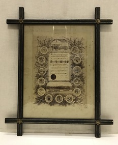
Certificate, Melbourne Tramways Trust, Framed Testimonial to Alderman Thomas O'Grady J.P. from the Melbourne Tramways Trust, 5 February 1886
The recipient of the testimonial, Thomas O’Grady (1824-90) had migrated to Melbourne in 1854, practising the trades of building and contracting. The Australian Dictionary of Biography records that he became a Councillor of the City of Melbourne in 1868. It lists one of his major achievements as the construction ‘with Leggett & Noonan [of] the fifty-six-mile (90 km) railway from Essendon to Seymour’. He was chairman of the Tramways Trust from its formation in 1884. His obituary in the Melbourne Herald (29 Apr 1890) reported: "DEATH OF ALDERMAN THOMAS O'GRADY. Today we have the sad duty of recording the death of two old colonists, who for many years, havo occupied very, prominent positions in building, commercial and municipal circles. The first of these is Alderman Thomas O'Grady, who died last night at his residence in Carlton. Mr O'Grady has been ill for some time, and at one period his death was expected any moment. Then he rallied, and strong hopes of his recovery were entertained; but he had a relapse, and expired as stated. The deceased gentleman was one of the oldest members of the City Council, in which he has held the various positions of Councillor, Alderman and Mayor. At the time of his death he sat as alderman for Victoria Ward. Mr O'Grady also at one time represented the City Council on the Harbor Trust, and was chairman of that body. He has been the council's representative on the Tramway Trust and was chairman of that body for some considerable time." As late as 1951, the Advocate (11 Oct 1951) stated that: "To Alderman Thomas O'Grady, Lord Mayor of Melbourne in 1872-3, is due the credit of the successful inauguration of Hospital Sunday. Alderman O'Grady was the first Catholic Lord Mayor of the city. He was elected a councillor for Smith Ward in 1868, and an alderman in 1869. In private life he was an extensive contractor, being a member of the firm of O'Grady, Leggett and Noonan, the contractors for the first section of the Northeastern Railways (between Melbourne and Seymour)."This is a unique civic document, illustrating the life and contribution of Thomas O’Grady (1824-90), Melbourne City Councillor and first Chairman of the Melbourne Tramways Trust. It is historically significant in its recording of the development of Melbourne's public transport system. The design of the certificate and particularly the ebonised frame are artistically and aesthetically significant.An illustrated testimonial presented to the first Chairman of the Melbourne Tramways Trust in 1886. The Testimonial is encased in an ebonized frame of the period. It includes the coat-of-arms of 12 cities, corporations, boroughs and towns, including that of Kew. At the head of the testimonial the engines used to drive the cable systems are illustrated. At the foot of the testimonial there is a picture of two cable trams.The testimonial reads: ‘At the meeting of the Melbourne Tramways Trust held on the Fifth Day of February 1886, the following resolution was unanimously carried. That the thanks of the Melbourne Tramways Trust are due and are hereby accorded to Alderman Thomas O’Grady Hon. JP, the first Chairman of the Trust for the ability, courtesy and impartiality with which he has discharged his duties during the past two years, and the Trust heartily congratulates him on the successful opening during his term of office of the Richmond Tramway (the first Cable line constructed in Australia) and tenders him its earnest wishes for his future prosperity and welfare.’ melbourne tramways trust, thomas o’grady (1824-90), cable trams, lord mayors of melbourne -
 Camberwell Historical Society
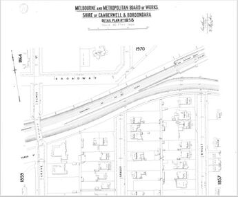
Map (Item) - MMBW map, Melbourne and Metropolitan Board of Works, Melbourne and Metropolitan Board of Works - Shire of Boroondara and Camberwell - Detail Plan no. 1858, August 1904
Lithographer E.H.H., Exd J.W.D, Aug 1904, No. 103. 40P.15W.melbourne and metropolitan board of works, map, camberwell, cartography -
 Kew Historical Society Inc
Plan, Melbourne & Metropolitan Board of Works : Borough of Kew : Detail Plan No.1575, 1905
The Melbourne and Metropolitan Board of Works (MMBW) plans were produced from the 1890s to the 1950s. They were crucial to the design and development of Melbourne's sewerage and drainage system. The plans, at a scale of 40 feet to 1 inch (1:480), provide a detailed historical record of Melbourne streetscapes and environmental features. Each plan covers one or two street blocks (roughly six streets), showing details of buildings, including garden layouts and ownership boundaries, and features such as laneways, drains, bridges, parks, municipal boundaries and other prominent landmarks as they existed at the time each plan was produced. (Source: State Library of Victoria)This plan forms part of a large group of MMBW plans and maps that was donated to the Society by the Mr Poulter, City Engineer of the City of Kew in 1989. Within this collection, thirty-five hand-coloured plans, backed with linen, are of statewide significance as they include annotations that provide details of construction materials used in buildings in the first decade of the 20th century as well as additional information about land ownership and usage. The copies in the Public Record Office Victoria and the State Library of Victoria are monochrome versions which do not denote building materials so that the maps in this collection are invaluable and unique tools for researchers and heritage consultants. A number of the plans are not held in the collection of the State Library of Victoria so they have the additional attribute of rarity.Original survey plan, issued by the MMBW to a contractor with responsibility for constructing sewers in the area identified on the plan within the Borough of Kew. The plan was at some stage hand-coloured, possibly by the contractor, but more likely by officers working in the Engineering Department of the Borough and later Town, then City of Kew. The hand-coloured sections of buildings on the plan were used to denote masonry or brick constructions (pink), weatherboard constructions (yellow), and public buildings (grey). Plan No.1575 shows that in the area bounded by Wellington Street, Edgevale Road, Glenferrie Road, and Cotham Road, there had already been significant subdivision of land and houses constructed. As one of the highest points in Kew, as expected, there were already some significant mansions built on large allotments of land. Many of these mansions are identified by name on the plan such as ‘Kelso’, ‘Abbotsford’, ‘Clarendon’ and ‘Ashlyn’ in Cotham Road. Other houses of equal size are unnamed on the plan.melbourne and metropolitan board of works, detail plans, maps - borough of kew, mmbw 1575, cartography -
 Greensborough Historical Society
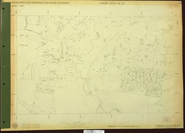
Map, Melbourne and Metropolitan Board of Works. Survey Division, MMBW, Yarra 2500 / 15.23. Diamond Creek Reserve, 1978_02
Melbourne and Metropolitan Board of Works. Yarra 2500 [base map] 15.23. Hurstbridge. Municipality of Diamond Valley 257. Prominent streets include: Challenger Street, James Cook Drive and Ryans Road / Main Street. Features include the Diamond Creek and Diamond Creek Reserve.MMBW Map in 1:2500 [scale] series. Cream parchment with green tape reinforcing on edges and punched holes on left edge.mmbw, melbourne and metropolitan board of works, shire of diamond valley, diamond creek - maps -
 Greensborough Historical Society
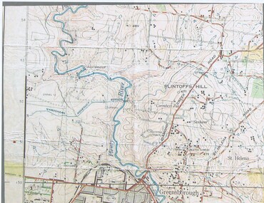
Map, John Monash, 1913 Map of Greensborough, 1913
1913 Map of Greensborough, possibly by John Monash. This map shows the area to the north of the township.Map, colour.greensborough - maps, 1913 -
 Orbost & District Historical Society
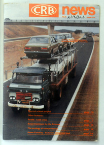
magazine, CRB News, August 1976
... Country Roads Board ...By 1910 it had become apparent that there was a need for a central roads authority to take over responsibility from the Board of Lands and Works for the care and management of the main roads of the state of Victoria. Because there was no consistent and systematic policy for road maintenance Victorian roads were in a deplorable condition. At this time the use of the motor car accentuated the demands for better roads. As a result of these needs the Country Roads Act 1912 was proclaimed in 1913 providing for the establishment of the Country Roads Board as a central road authority with responsibility for those roads within the State considered to be main roads. the C.R.B. was responsible for the construction of roads and bridges including the Snowy River road bridges in Orbost. This was a major project involving not only a new bridge over the Snowy River (including Lochiel Lagoon), but other bridges over Ashby’s Gulch and Watt’s Gulch. These new bridges were opened in November 1976 with the unveiling of a plaque on the eastern end of the $2.4M Snowy River Bridge. (ref. May Leatch) This is a useful reference tool on the history of the construction of the Snowy River road bridges.A journal, titled "CRB News" . On the front cover the title is in orange print with No. 33 August 1976 above a coloured photo of a truck carrying two tiers of new vehicles along a main sealed road. It contains information and photos of the construction of the Snowy River road bridges.on front cover - handwritten in black - "M. I. Gilbert"crb-news country-roads-board snowy-river-road-bridges -
 Greensborough Historical Society
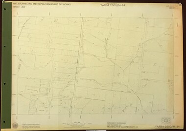
Map, Melbourne and Metropolitan Board of Works. Survey Division, MMBW, Yarra 2500 / 14.24. Plenty, 1979_05
Melbourne and Metropolitan Board of Works. Yarra 2500 [base map] 14.24. Plenty. Parishes of Nillumbik 3310 and Morang 3183. Municipality of Diamond Valley 257. Prominent streets include: Heard Road, Hillmartin Road and Yan Yean Road. Features include Plenty Primary School and Plenty Park.MMBW Map in 1:2500 [scale] series. Cream parchment with green tape reinforcing on edges and punched holes on left edge.mmbw, melbourne and metropolitan board of works, shire of diamond valley, plenty - maps -
 Greensborough Historical Society
Map, Melbourne and Metropolitan Board of Works. Survey Division, MMBW, Yarra 2500 / 14.27. Yarrambat, Yan Yean Road, 1978_04
Melbourne and Metropolitan Board of Works. Yarra 2500 [base map] 14.26. Yarrambat, Yan Yean Road. Parishes of Morang 3183 and Greensborough 2724. Municipality of Diamond Valley 257. Prominent streets include: Yan Yean Road, North Oatlands Road and Pioneer Road. Features include Yarrambat War Memorial Reserve.MMBW Map in 1:2500 [scale] series. Cream parchment with green tape reinforcing on edges and punched holes on left edge.mmbw, melbourne and metropolitan board of works, shire of diamond valley, whttlesea, yarrambat - maps -
Port Melbourne Historical & Preservation Society
Document - Booklet, Port Melbourne Historical and Preservation Society (PMHPS), The story of Sandridge, how the first settlers came to Port Melbourne. A history for children, c 1999
Sponsored by Holden and produced by Port Melbourne Historical and Preservation SocietyA history of Sandridge/Port Melbourne specifically aimed at children. Square buff coloured booklet with a black and white drawing of a rowing boat on the cover.Booklet is notated in red, dates and extra information.sandridge lagoon, garden city, piers and wharves - town pier, piers and wharves - railway pier, melbourne to hobson's bay railway, built environment, heritage, caroline frederica liardet, wilbraham frederick evelyn liardet, port melbourne yacht club, thomas swallow, william morley, david thomas, peter lalor, andrew plummer -
 Greensborough Historical Society
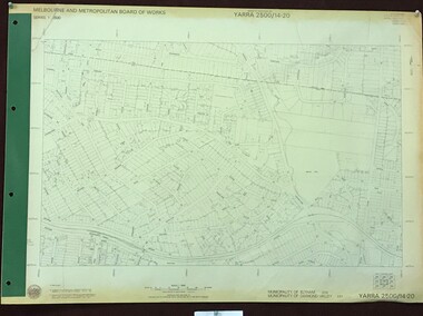
Map, Melbourne and Metropolitan Board of Works. Survey Division, MMBW, Yarra 2500 / 14.20. Montmorency, Sherbourne Road, 1977_06
Melbourne and Metropolitan Board of Works. Yarra 2500 [base map] 14.20. Montmorency, Sherbourne Road. Municipality of Diamond Valley 257 and Eltham 238. Prominent streets: Sherbourne Road, Karingal Drive and Calrossie Avenue. Features include Montmorency Station and Meruka Park.MMBW Map in 1:2500 [scale] series. Cream parchment with green tape reinforcing on edges and punched holes on left edge.mmbw, melbourne and metropolitan board of works, shire of diamond valley, montmorency - maps -
 Kew Historical Society Inc
Plan, Melbourne & Metropolitan Board of Works : Borough of Kew : Detail Plan No.1350, 1910
The Melbourne and Metropolitan Board of Works (MMBW) plans were produced from the 1890s to the 1950s. They were crucial to the design and development of Melbourne's sewerage and drainage system. The plans, at a scale of 40 feet to 1 inch (1:480), provide a detailed historical record of Melbourne streetscapes and environmental features. Each plan covers one or two street blocks (roughly six streets), showing details of buildings, including garden layouts and ownership boundaries, and features such as laneways, drains, bridges, parks, municipal boundaries and other prominent landmarks as they existed at the time each plan was produced. (Source: State Library of Victoria). This plan forms part of a large group of MMBW plans and maps that was donated to the Society by the Mr Poulter, City Engineer of the City of Kew in 1989. Within this collection, thirty-five hand-coloured plans, backed with linen, are of statewide significance as they include annotations that provide details of construction materials used in buildings in the first decade of the 20th century as well as additional information about land ownership and usage. The copies in the Public Record Office Victoria and the State Library of Victoria are monochrome versions which do not denote building materials so that the maps in this collection are invaluable and unique tools for researchers and heritage consultants. A number of the plans are not held in the collection of the State Library of Victoria so they have the additional attribute of rarity.Original survey plan, issued by the MMBW to a contractor with responsibility for constructing sewers in the area identified on the plan within the Borough of Kew. The plan was at some stage hand-coloured, possibly by the contractor, but more likely by officers working in the Engineering Department of the Borough and later Town, then City of Kew. The hand-coloured sections of buildings on the plan were used to denote masonry or brick constructions (pink), weatherboard constructions (yellow), and public buildings (grey). MMBW Plan No. 1350 depicts the western end of Studley Park on the north side of the Studley Park Road. ‘Raheen’, then the home of Sir Henry Wrixon is named, the plan identifying those parts of the house that were built of brick and timber. The two houses between Raheen and the River Yarra are also shown. Other parts of the plan show neighbouring streets: Yarra Street, Studley Park Avenue, Studley Street and Fenwick Street. Each, apart from Fenwick Street was subsequently renamed. At the corner of Fenwick and Stawell Streets, the home of Joseph Butterworth Coombs, later called ‘Hope Mansell’, is represented but unnamed.melbourne and metropolitan board of works, detail plans, mmbw 1350, cartography -
 Bendigo Historical Society Inc.
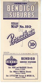
Map - Three Road Maps of Bendigo, 1962
George Robert Broadbent (1863-1947), cyclist and map publisher, was born on 3 November 1863 at Ashby near Geelong, Victoria, son of George Adam Broadbent, Lancashire-born draper, and his wife Elizabeth, née Ruffhead. When the family moved to North Melbourne Broadbent attended the Errol Street school, followed his father's trade, and became an early cycling and cycle-racing enthusiast. At various times Broadbent held most Victorian and Australian road records, and two of his performances on solid tyres—203 miles (327 km) in 24 hours on a penny farthing, and 100 miles (161 km) in 6 hours 20 minutes on a 'safety' bicycle—were never bettered. He established records for all distances between 130 and 220 miles (209 and 354 km), and for all times between 8 and 12 hours, at the Exhibition Grounds track in May 1894, and road records for 50 and 100 miles (80 and 161 km) in October 1896. The Australian Cyclist acknowledged him 'the finest road rider that Australia has ever produced'. A foundation councillor of the League of Victorian Wheelmen in October 1893, Broadbent contested the first Warrnambool-Melbourne race in 1895, and was active in the Good Roads Movement. Next year he issued a road map of Victoria, 'prepared … after some sixteen years riding and touring in all parts of the Colony', which indicated general topography, distances, and roads classified as 'good', 'fair' or 'ridden with difficulty'. It was to become Victoria's standard map, and the basis of a continuous publishing programme by Broadbent's Official Road Guides Co.Three Road Maps of Bendigo, Bendigo and Suburbs, Bendigo and Eaglehawk. Two fold out maps printed in colour and produced by Broadbent's Road Maps Pty. Ltd. 475 Collins Street Melbourne. One map printed by Bolton's Bendigo.history, bolton's, bendio broadbent maps -
 Greensborough Historical Society
Map, Melbourne and Metropolitan Board of Works. Survey Division, MMBW, Yarra 2500 / 13.21. Central Greensborough, 1979_05
Melbourne and Metropolitan Board of Works. Yarra 2500 [base map]. 13-21, Parishes of Keelbundora 2856 and Nillumbik 3310, Municipality of Diamond Valley 257. Shows street names, easement sizes, lot numbers, lodged plan numbers, names of prominent features, contour values, creek or river names. Central Greensborough. Prominent streets: Main Street, Para Road, St Helena Road and Diamond Creek Road.MMBW Map in 1:2500 [scale] series. Cream parchment with green tape reinforcing on edges and punched holes on left edge.mmbw, melbourne and metropolitan board of works, shire of diamond valley, greensborough - maps -
 Greensborough Historical Society
Map, Melbourne and Metropolitan Board of Works. Survey Division, MMBW, Yarra 2500 / 15.24. Diamond Creek, Grassy Flat Road, 1978_02
Melbourne and Metropolitan Board of Works. Yarra 2500 [base map] 15.24. Diamond Creek, Grassy Flat Road. Parish of Nillumbik 3310. Municipality of Diamond Valley 257. Prominent streets include: Everleigh Drive, Broad Gully Road and Clyde Street. Features include the Diamond Creek, Nillumbik Park and Diamond Creek Reservoir.MMBW Map in 1:2500 [scale] series. Cream parchment with green tape reinforcing on edges and punched holes on left edge.mmbw, melbourne and metropolitan board of works, diamond creek - maps, shire of diamond valley -
 Camberwell Historical Society
Map (Item) - MMBW map, Melbourne and Metropolitan Board of Works, Melbourne and Metropolitan Board of Works - Shire of Boroondara and Camberwell - Detail Plan no. 1845, August 1904
Lithographer JEM, exd. JWD, June 1904, no. 71. 40P.15W.melbourne and metropolitan board of works, map, camberwell, cartography -
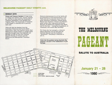 Melbourne Tram Museum
Pamphlet, Melbourne Pageant Committee, "The Melbourne Pageant - January 21 - 28 1980 - Salute to Australia, Cavalcade of Transport", 1980
Pamphlet - 3 fold DL - titled "The Melbourne Pageant - January 21 - 28 1980 - Salute to Australia, Cavalcade of Transport" advertising the planned events and dates with a map. Has name of Neil McPhee - chairman of Melbourne Pageant Committee Two copies held.trams, tramways, australia day, mmtb, melbourne, tramcars, pageant, melbourne pageant -
 Greensborough Historical Society
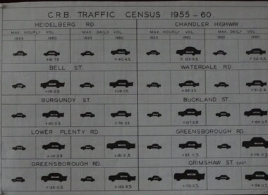
Diagram, C. R. B. Traffic Census 1955-1960, 07/06/1960
... Country Roads Board...Country Roads Board ...The Country Roads Board, which had responsibility for major metropolitan roads, conducted a census of maximum hourly and daily traffic volumes recorded in 1955 and 1960 on 10 major roads in the Heidelberg and Greensborough areas.Black and white table G.M.H.traffic, heidelberg, greensborough, country roads board -
 Kew Historical Society Inc
Plan, Melbourne & Metropolitan Board of Works : Borough of Kew : Detail Plan No.1301, 1910
The Melbourne and Metropolitan Board of Works (MMBW) plans were produced from the 1890s to the 1950s. They were crucial to the design and development of Melbourne's sewerage and drainage system. The plans, at a scale of 40 feet to 1 inch (1:480), provide a detailed historical record of Melbourne streetscapes and environmental features. Each plan covers one or two street blocks (roughly six streets), showing details of buildings, including garden layouts and ownership boundaries, and features such as laneways, drains, bridges, parks, municipal boundaries and other prominent landmarks as they existed at the time each plan was produced. (Source: State Library of Victoria)This plan forms part of a large group of MMBW plans and maps that was donated to the Society by the Mr Poulter, City Engineer of the City of Kew in 1989. Within this collection, thirty-five hand-coloured plans, backed with linen, are of statewide significance as they include annotations that provide details of construction materials used in buildings in the first decade of the 20th century as well as additional information about land ownership and usage. The copies in the Public Record Office Victoria and the State Library of Victoria are monochrome versions which do not denote building materials so that the maps in this collection are invaluable and unique tools for researchers and heritage consultants. A number of the plans are not held in the collection of the State Library of Victoria so they have the additional attribute of rarity.Original survey plan, issued by the MMBW to a contractor with responsibility for constructing sewers in the area identified on the plan within the Borough of Kew. The plan was at some stage hand-coloured, possibly by the contractor, but more likely by officers working in the Engineering Department of the Borough and later Town, then City of Kew. The hand-coloured sections of buildings on the plan were used to denote masonry or brick constructions (pink), weatherboard constructions (yellow), and public buildings (grey). Throughout its history, the land in what is known today as Studley Ward of the City of Boroondara has been subject to continuing subdivision. This is evident in Plan 1301, where later hands have modified the original map to include streets created subsequent to the printing of the plan in 1904. Other annotations such as the ‘Reserved for Road Purposes’ beside the Yarra never eventuated. The plan continued to be modified to at least 1953, when a later hand noted that a particular site was ‘Property site P. McIntyre house’ in Swinton Avenue. Two significant houses in the area are outlined on the plan: ‘Swinton’ on the corner of the streets then named Effey and Maud Streets (now Swinton Avenue) and ‘Fairhaven’ [unnamed] in Stevenson Street. The gardens of the two David Syme owned mansions of ‘Blythswood’ and ‘Rockingham’, stretching down to the River Yarra, are also represented.melbourne and metropolitan board of works, detail plans, mmbw 1301, cartography -
 Melbourne Tram Museum
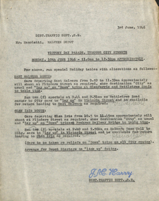
Document - Memorandum, Melbourne & Metropolitan Tramways Board (MMTB), "Victory Day Parade, through city streets", Apr. 1946
... "Victory Day Parade, through city streets" ...Parade of units of victory march personnel through city streets Monday 10 June 1946 - 11:00AM to 12:30PM Memos from JM Harry, Dist Traffic Supt SS regarding tram arrangements to Mr Mazolettti, Malvern Depot, Mr McLean, Hanna St, Mr Cliff, Glenhuntly Depot, Mr Fisher, Hawthorn Depot, Mr Head, Camberwell, Mr Lawrence, Port Melbourne, Mr McRae, Central Bus Garage Memos dated 3 June 1946. Letter from JM Harry regarding bus services. Letter from HS Wootton, town clerk. Documents from ADFNotations written in pencil on memo.trams, tramways, events, parades, malvern depot, hanna st depot, hawthorn depot, central bus garage -
 Greensborough Historical Society
Map, Melbourne and Metropolitan Board of Works. Survey Division, MMBW, Yarra 2500 / 13.19. Lower Plenty, Montmorency, Yallambie, 1979_02
Melbourne and Metropolitan Board of Works. Yarra 2500 [base map] 13-19. Lower Plenty, Montmorency, Yallambie. Parishes of Keelbundora 2856 and Nillumbik 3310. Municipalities of Heidelberg 228, Diamond Valley 257 and Eltham 238. Prominent streets include: Elder Street, Para Road, and Main Road Lower Plenty. Includes Watsonia Army Barracks.MMBW Map in 1:2500 [scale] series. Cream parchment with green tape reinforcing on edges and punched holes on left edge.mmbw, melbourne and metropolitan board of works, shire of diamond valley, montmorency - maps, yallambie - maps, lower plenty - maps -
Port Melbourne Historical & Preservation Society
Booklet, Port Melbourne Football Club, Port Melbourne Football Club Year Book, 1968
Port Melbourne Football Club Year Book 1968. Red and blue strped coversport - australian rules football, port melbourne football club, pmfc -
 Mission to Seafarers Victoria
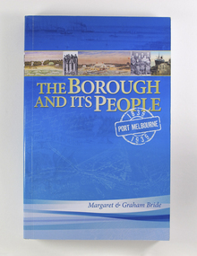
Book, Port Melbourne Historical and Preservation Society et al, The Borough and Its People: Port Melbourne 1839-1939, 2013
Soft cover book of 293 pages; Appendix, Sources of Images, Endnotes, Bibliography and Index, by Margaret and Graham Bride. Front cover is sky blue and features a 2.5 cm wide strip of five small photos above the cream coloured title. Organisational logos on the back; Port Melbourne Historical and Preservation Society, City of Port Phillip, Port of Melbournenon-fictionport melbourne, early settlers, port of melbourne, port phillip, reverend kerr johnston, seamen's mission, mission to seafarers, sandridge, bethel, church, hulk emily, pmhps, pat grainger