Showing 1869 items matching "subdivision"
-
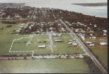 Inverloch Historical Society
000080 - Photograph - Parcel of land fo subdivision on Toorak Rd between Ullathorne Road and Florida Avenue - R Young
-
 University of Melbourne, Burnley Campus Archives
Document, Scale of rates of annual salaries of each subdivision of each class, 1977
Determinations under [Victorian]Public Service Act 1974burnley horticultural college, salaries -
Stawell Historical Society Inc
Map, W.J. Butson, Subdivision of North Woodlands Estate 1922, 12.02.1922
Two (2) Copies. A1 Maps with Cloth Backing Annotated with Title HoldersParishes of Malkaff & Navarre County of Kara Kara Photlithograph by W.J Butson 12.02.2022farming -
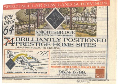 Whitehorse Historical Society Inc.
Newspaper - Advertisement, Knightsbridge Subdivision, 30/04/1997
Advertisment for Knightsbridge, Dunlavin Road Nunawading. 64 Brilliantly positioned prestige home sites priced from $95,000 to $129,950.knightsbridge subdivision, dunlavin road nunawading -
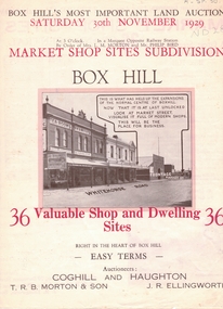 Whitehorse Historical Society Inc.
Document, Market Shop Sites subdivision, 20/11/1929 12:00:00 AM
5 pages describing sale of land in Whitehorse Road,5 pages describing sale of land in Whitehorse Road, Market Street, Box Hill5 pages describing sale of land in Whitehorse Road,land subdivision, market street, box hill, coghill & haughton, t.r.b. morton & son, ellingworth, john roger -
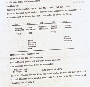 Whitehorse Historical Society Inc.
Document, Land subdivision, n.d
notes of records of land dealings in parts of Crown Portions 120 and 111, 1858 - 1886.Photocopy of notes of records of land dealings in parts of Crown Portions 120 and 111, 1858 - 1886. notes of records of land dealings in parts of Crown Portions 120 and 111, 1858 - 1886.land subdivision, richards, thomas, mcglone, john, gilligan, patrick, emery, henry, parsons, charles robert, lobb, graham, gale, alfred chaplin, mitcham brick and pottery co. ltd -
 Whitehorse Historical Society Inc.
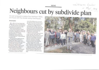
Article, Neighbours Oppose Subdivision Plan
Neighbours are opposed to the removal of a 1950's house.Neighbours are opposed to the removal of a 1950's house to be replaced by 5 double-storey townhouses at 124 -126 Blackburn Rd which would require removal of 39 of the 45 trees on site.Neighbours are opposed to the removal of a 1950's house.blackburn, whitehorse planning scheme, blackburn road blackburn nos. 124 -126, blackburn village residents' group -
 Kew Historical Society Inc
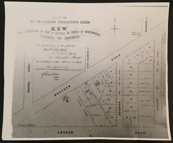
Print - Subdivision Plan, F Price, Plan of Mr William Derrick's Land, Kew being Subdivision of Part of Section 86, Parish of Boroondara, County of Bourke, 1872, 1872 [Original]
This work forms part of the collection assembled by the historian Dorothy Rogers, that was donated to the Kew Historical Society by her son John Rogers in 2015. The manuscripts, photographs, maps, and documents were sourced by her from both family and local collections or produced as references for her print publications. Many were directly used by Rogers in writing ‘Lovely Old Homes of Kew’ (1961) and 'A History of Kew' (1973), or the numerous articles on local history that she produced for suburban newspapers. Most of the photographs in the collection include detailed annotations in her hand.The Rogers Collection provides a comprehensive insight into the working habits of a historian in the 1960s and 1970s. Together it forms the largest privately-donated collection within the archives of the Kew Historical Society.A photographic reproduction of a plan in the Vale Collection of the State Library of Victoria showing William Derricks land in the area bordered by Bulleen Road (High Street); Cotham Road and Union Street. The plan dates from 1872.william derrick, subdivision plans -- kew (vic.) -
Stawell Historical Society Inc
Map - Subdivision map, Subdivision of North Woodlands Estate Map
Shows Homestead Cottage and Dam, Plus Shed. Malakoff NavarreA3 photocopy of MapParishes of Malakoff and Navarre. County of Kara karasurvey -
 Ringwood and District Historical Society
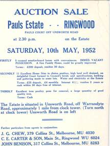
Flyer - Auction Sale, Pauls Estate Subdivision, Pauls Court off Unsworth Road, Ringwood, Victoria - 1952
Double-sided page advertising auction on Saturday, 10th May, 1952 in 3 parts. "Firstly - 5 roomed weatherboard house with conveniences. Immediate vacant possession. ... Terms: £200 deposit, residue 30 days". "Secondly - 11 excellent home sites. ... Terms: £25 deposit, £4 monthly. Interest 4-1/2%, residue 2 years or cash within 30 days free of interest". "Thirdly - Excellent iron poultry pens for removal, a large quantity of good quality iron. Terms: Cash". Agents in conjunction: J.G. Chew, 379 Collins Street, Melbourne, (phone) MU4030, C.E. Carter & Son, Main Street, Ringwood, (phone) WU6024, John Benison, 317 Collins Street, Melbourne, (phone) MU8283. -
 Ringwood and District Historical Society
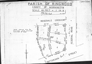
Document - Folder, Map of Subdivision for auction - Ringwood East, Vic., 1973
Photocopy of Parish Map showing five residential blocks for sale on Rosedale Crescent, Federal Road and Patterson Street Ringwood East.Accompanying handwritten sales notes researched in 2024 by Richard Carter - Carter Real Estate - "5 lots (heavily filled) auction 14 July 1973. All later sold $4000 each - unknown agent". -
University of Melbourne, Burnley Campus Archives
Plan, Ratio Consultants Pty. Ltd, Conceptual Subdivision & Garden Layout Plan Project 'Rosecraddock' Rosecraddock Place Caulfield, 1991
Tracing paper plan by Ratio Consultants Pty. Ltd., for Mr P. Shellard, Project No 1887, drawing No LS3, October 1991. Scale 1:250.p. shellard, caulfield, ratio consultants, "rosecraddock", subdivision plans, landscape design -
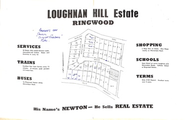 Ringwood and District Historical Society
Document - Folder, Subdivision Map - Loughnan Hill Estate, Ringwood, Victoria - circa 1960
Open centre page of land sale brochure glued to manilla folder. Map of residential and shop sites in Burlock Road (later Burlock Avenue), Adolphson Avenue and Felix Crescent, Ringwood, with summary of estate facilities and local services. Agent - T.G. Newton.(Page glued to manilla folder prevents access to front page for further sale information) -
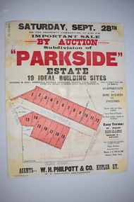 Warrnambool and District Historical Society Inc.
Work on paper - Original Document, H J Paynter, Advertisement "Parkside"Estate subdivision, Circa 1935
This sheet denotes an auction of land which is situated close to Albert Park on the northern part of Warrnambool. The area is complete now with homes which are a mixture of brick and concrete faced houses. The agent W H Philpott was operating in Warrnambool from the 1930's though to 1950'sThis item has local interest and significance as it records the sale of Warrnambool land.Large white paper sheet with black and red text. The auction details are at the top and down the righthand side with a map of the available blocks are coloured red and outlined in black.Parkside estate, W H Philpott & Co Kepler St , R V Philpott auctioneer,Solicitors J S Tait & son. Cramer Street, Nelson Street McConnell Street.warrnambool, mcconnell street warrnambool -
Lakes Entrance Historical Society
Book, Commonwealth of Australia, Division of Gippsland. Roll of electors for the subdivision of Cunninghame.1905, 1905
Alphabetical list of persons on the electoral roll for Cunninghame, Division of Gippsland in 1905. Gives name, sex, place of living and occupation. Also electoral roll for 1912 also 1985 Orbost Shire rates people living in Reeves River .estimated populdirectories -
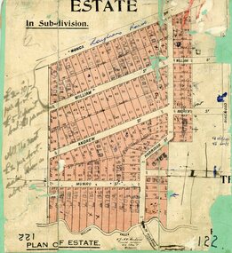 Ringwood and District Historical Society
Map, Subdivision Plan, Loughnans Road, Ringwood - circa 1922
Green card with cut-out map of residential allotments, some marked "sold". "Plan of Estate" includes Wonga Road, Loughnans Road, William Street, Andrew Street, Harrison Street, and Munro Street, Ringwood. (Surrounding area is part of Ringwood Park Estate featured in seperate 1922 auction flyer).Handwritten notations - (northern section) {£2-10/- per foot. £5 deposit bal £1 per month} All the rest £2 per foot, value same as above. Licensed Surveyors - W.J. & A.W. Kenhardt, 352 Collins Street, Melbourne. -
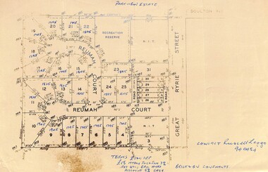 Ringwood and District Historical Society
Map, Parkview Estate Subdivision, Heathmont, Victoria - 1965
Map showing residential allotments for sale in Reumah Court and Great Ryrie Street, Heathmont, Victoria.Hand-written heading and real estate sales notations include prices on several allotments. Terms £100 Deposit £15 monthly including interest 7% adjusted quarterly. Balance 4 years. Discount 5% cash. Brick and BV covenants. Contact Russell Leggo (Telephone) 940484. -
 Ringwood and District Historical Society
Document, Subdivision Map - Unsworth Road, Ringwood, Victoria (Undated)
Single page photocopy of hand-drawn map - 9 numbered residential allotments with imperial measurements.Handwritten pen notations include land title reference - LP111235. -
 Ringwood and District Historical Society
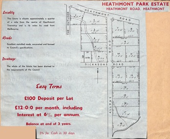
Document, Plan of Subdivision - Heathmont Park Estate (undated, circa 1949)
Land sale brochure clipping with map showing layout and sizes of 18 residential allotments in The Outlook, Heathmont Road, Allens Road and Dickasons Road, Heathmont, Victoria.Easy terms. £100 deposit per lot. £12:0:0 per month including interest at 6% per annum. Balance at end of 3 years. 5% for cash in 30 days. -
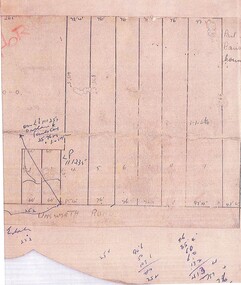
 Ringwood and District Historical Society
Map, Plan of Subdivision
Hand-drawn map on light cardboard backing. 20 residential allotments in Whitehorse Road, Everard Road and Kemps Street, Ringwood East, Victoria (undated circa 1940s).Vol 3956 Fol 015, Vol 4288 Fol 564, LP5252. -
 Ringwood and District Historical Society
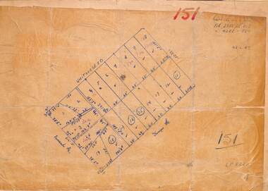
Document, Plan of Subdivision
Hand-drawn map on light cardboard backing. Six residential allotments in Glenvale Road and Hygeia Parade, Ringwood, Victoria (undated, circa 1940). -
 Ringwood and District Historical Society
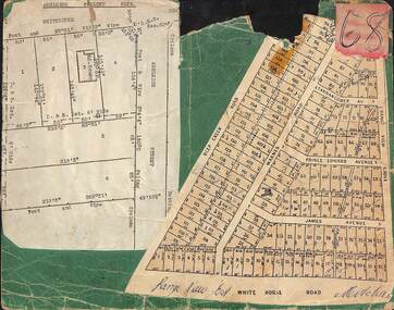
Card, Collage of Residential Subdivision Map Clippings - Ashleigh Poultry Farm, Blackburn, Vic and Range View East, Mitcham, Vic. (Undated, circa 1930s)
Weekly Times (Melbourne, Vic.) Sat 24 Aug 1935 Page 6 - 1800 Chickens Burnt. Starting in the incubator room, a fire at the Ashleigh Poultry Farm, Whitehorse Road Blackburn, early on August 20, incinerated 1800 young chickens and 1000 eggs. The incubator room and the chicken pens were reduced to ashes, but a large drum of kerosene standing in the room was undamaged! The owners of the farm, Mrs N. Foote and her sons, have suffered a severe setback, as practically all their chickens and eggs are gone, and it is too late to start hatching again this season.Two maps mounted on green cardboard. 1. Ashleigh Poultry Farm - Layout of weatherboard house and six residential allotments on Whitehorse Road and Ashleigh Street (later Ashburn Place), Blackburn, Victoria. 2. 140 allotments with frontages on Deep Creek Road, Warnes Road, Range View Grove, Tarrangower Avenue, Prince Edward Avenue, James Avenue and White Horse Road, Mitcham, Victoria. -
 Ringwood and District Historical Society
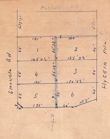
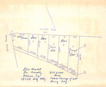
Document, Plan of Subdivision
Hand-drawn map of 6 residential allotments in Montalbo Road off Hygeia Parade, Ringwood, Victoria (undated, circa 1940).Real estate notations include prices, terms of sale, and a telephone number XM4200. -
 Ringwood and District Historical Society
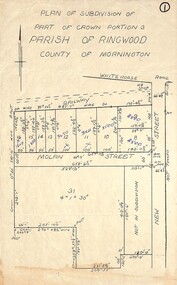
Map, Plan of Subdivision - Part of Crown Portion 3, Parish of Ringwood, County of Mornington (Undated, circa 1930s)
Hand-drawn map of subdivided allotments in Molan Street and New Street Ringwood, south of railway line.Real estate sales notations on some allotments possibly added post decimal currency changeover date, 1966. Weatherboard shop marked on south-west corner of New Street and Whitehorse Road. -
 Eltham District Historical Society Inc
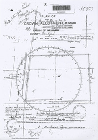
Document - Photocopy, Survey Field Notes of Part of Crown Portion 13, Section 4 at Eltham, Part of Lot 19 Subdivision of 13 Section IV (Holloways), Parish of Nillumbik, County of Evelyn, 5 May 1906
Portion of land bounded by: Main Road, Henry Street Application 35953 A. Mackensie Tyers, Licensed Surveyor, 5 May 1906map, neil webster collection, survey plan, surveyor field notes, 1906, application 33777, application 35953, henry street, main road eltham, maria street, rechabite hall* -
 Ringwood and District Historical Society
Document - Map, Plan of Subdivision - Part of Crown Allotments 14A & 14C, Parish of Ringwood, County of Mornington, Vol 5378 Fol 511 - 1927
Department of Lands and Survey photocopy dated 17/1/1951, page number 12308.Map includes Canterbury Road, Heathmont Road, Dickasons Road, Bennett Avenue, Orchid Street and Allens Road, Heathmont, Vic. -
 Ringwood and District Historical Society
Document, Plan of Subdivision - Part of Crown Portion 5, Parish of Ringwood, County of Bourke - (Undated)
Map showing layout of 4 numbered allotments coloured red and land coloured blue appropriated or set aside for drainage and sewerage puposes.Map includes Nelson Street and Ringwood Street, Ringwood, Vic. -
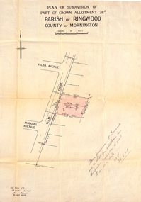 Ringwood and District Historical Society
Document, Plan of Subdivision - Part of Crown Allotment 26A, Parish of Ringwood, County of Mornington - Circa 1961
Map showing layout of 2 allotments coloured red in Velma Grove, adjacent to Valda Avenue and Mirabel Avenue, Ringwood East, Vic.Handwritten notation dated 29/8/1961 by Alf King, Licensed Surveyor, 14 Grace Street, Mont Albert (Phone) WX2020 regarding plans being forwarded to Council for inspection visit. -
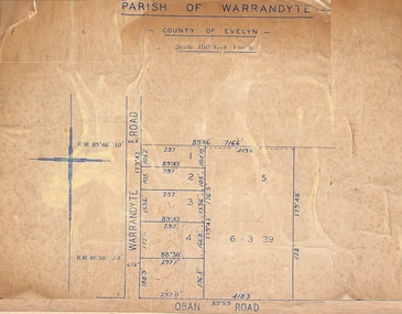 Ringwood and District Historical Society
Map, Subdivision Plan of 5 residential allotments on Warrandyte Road and Oban Road, Ringwood, Victoria - (Undated - pre 1950s)
Partial copy of Crown Allotment Map on cardboard backingParish of Warrandyte, County of Evelyn. -
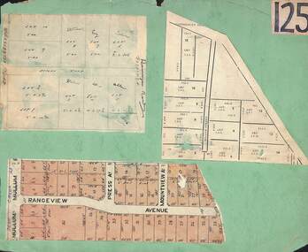 Ringwood and District Historical Society
Card, Collage of Residential Subdivision Map Clippings - Ringwood, Victoria - (Undated)
Three maps mounted on green cardboard - Hand-drawn map of residential allotments off Warrandyte Road in Milne Road and Berringa Road Park Orchards. Map with acres roods and perches measurements of allotments in Canterbury Road and Miller Street Heathmont. Clipping from a land sale brochure with street names not existing together in the area - Rangeview Avenue, Press Avenue and Mountview Avenue.