Showing 840 items
matching subdivision plans
-
 Whitehorse Historical Society Inc.
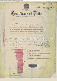
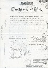
Legal record - Document, Certificate of Title, 1977
... 13 Plan of Subdivision no. 4488, cnr. Creek Road and East... of Lot 13 Plan of Subdivision no. 4488, cnr. Creek Road and East ...Certificate of Title vol. 5564 fol. 1112691 for part of Lot 13 Plan of Subdivision no. 4488, cnr. Creek Road and East Road Mitcham, owned by George Albert SmithCertificate of Title vol. 5564 fol. 1112691 for part of Lot 13 Plan of Subdivision no. 4488, cnr. Creek Road and East Road Mitcham, owned by George Albert SmithCertificate of Title vol. 5564 fol. 1112691 for part of Lot 13 Plan of Subdivision no. 4488, cnr. Creek Road and East Road Mitcham, owned by George Albert Smithcreek road mitcham, smith, george albert, east road mitcham -
Whitehorse Historical Society Inc.
Legal record - Land Title, Deep Creek Road, Mitcham, 1936
... Certificate of Title vol 6087 Fol 1217316 Lot 133 of plan... Fol 1217316 Lot 133 of plan of subdivision no 8022 in the name ...Certificate of Title vol 6087 Fol 1217316 Lot 133 of plan of subdivision no 8022 in the name of Francisco Schwerkolt on 22 Dec 1936 including transactions until Oct 2000.Certificate of Title vol 6087 Fol 1217316 Lot 133 of plan of subdivision no 8022 in the name of Francisco Schwerkolt on 22 Dec 1936 including transactions until Oct 2000.Certificate of Title vol 6087 Fol 1217316 Lot 133 of plan of subdivision no 8022 in the name of Francisco Schwerkolt on 22 Dec 1936 including transactions until Oct 2000.schwerkolt, francisco, deep creek road, mitcham, no 27., rangeview grove, hogan, frances dora, collins, douglas alexander, oulton alice, vicic, susan manuella, hammond, wayne, alexander, hannelore -
 Bendigo Historical Society Inc.
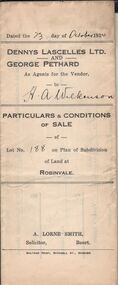
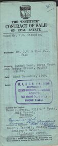
Document - H.A. & S.R. WILKINSON COLLECTIONCONDITION OF SALE
... Particulars & conditions of sale of lot no. 188 on plan... & conditions of sale of lot no. 188 on plan of subdivision of land ...Particulars & conditions of sale of lot no. 188 on plan of subdivision of land at Robinvale between Dennys Lascelles Ltd + George Pethard as agents for the vendor and H. A. Wilkinson (buyer). Price 63 pounds.organization, business, h.a. & s.r wilkinson real estate -
 Whitehorse Historical Society Inc.
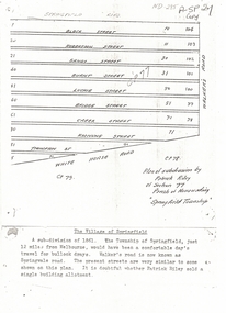
Document, Plan of Subdivision, 1861
... Plan of Subdivision...Copy of plan of subdivision by Patrick Riley of Section 77... of subdivision by Patrick Riley Copy of plan of subdivision by Patrick ...Copy of plan of subdivision by Patrick RileyCopy of plan of subdivision by Patrick Riley of Section 77, Parish of Nunawading 'Springfield Township' 1861. Bounded by Whitehorse Road, Walker's Road, (now known as Springvale Road) and Springfield RoadCopy of plan of subdivision by Patrick Rileyland sales, riley, patrick, whitehorse road, nunawading, walkers road, springfield road, black street, robertson street, sandy street, burnt street, luckie street, bridge street, creek street, koonung street, thompson street -
 Kew Historical Society Inc
Document - Urban Planning Document, City of Kew, City of Kew : Minimum Size of Allotment Required, 1945-1955
... to be smaller. The document was pasted on the reverse of a subdivision... of a subdivision plan in the collection. This is a rare (undated) document ...A document outlining the relevant by-laws produced by the City Of Kew to regulate the minimum size of allotments in Barkers Road, Burke Road, Cotham Road, Glenferrie Road and Studley Park Road, as well as in other streets more generally. The by-laws specify the size of allotments in which single unit dwellings, attached houses and maisonettes, and flats could be built. In the ‘main streets’ a minimum land area for single unit dwellings was 8,100 square feet, with an average frontage of 60’ and a depth of 135’. In other streets this was reduced to an overall size of 6,250 square feet, with an average dimensions of 50’ x 125’. In specifying the land area required by flats, different sizes were regulated for the construction of between two and six flats. Six flats at the time when the regulations were passed must have been the upper limit permitted. Understanding the size of land listed in imperial measurements can be a challenge. Within Australia, the so-called quarter acre block was approximately 11,000 square feet. Those specified in the by-laws would appear to be smaller. The document was pasted on the reverse of a subdivision plan in the collection.This is a rare (undated) document produced by the City of Kew defining how subdivision within the municipality should occur. The document was created to constrain unbridled speculation in subdivisions in the various parts of Kew and East Kew.Undated typed document, issued by the City of Kew (1921-1994) indicating the minimum size of allotment required in Barkers Road, Burke Road, Cotham Road, Glenferrie Road and Studley Park Road. The document is mounted on board and waterstained. It was presumably used by a real estate agent. [Formerly catalogued as MAP.0066].city of kew - by-laws and regulations, subdivisions - kew - studley park -
 Eltham District Historical Society Inc
Document - Property Binder, 60 Kent Hughes Road, Eltham
... 1. Certificate of Title of Lot 22 on Plan of Subdivision... melbourne 1. Certificate of Title of Lot 22 on Plan of Subdivision ...1. Certificate of Title of Lot 22 on Plan of Subdivision No. 7894 and other material pertaining to Mary Frances Carrucan (nee Sweeney) and family connections (Digital file only)eltham, 60 kent hughes road, certificate of title, mary frances carrucan (nee sweeney) -
 Whitehorse Historical Society Inc.
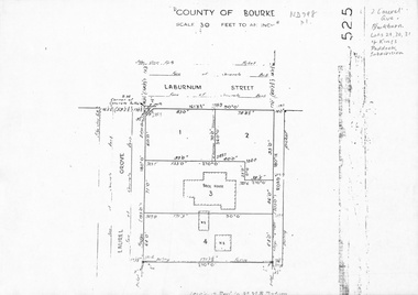
Map, Laurel Grove, 1959
... Plan of subdivision, part of Crown Portion 84, Lots 29, 30... subdivision kings paddock Plan of subdivision, part of Crown Portion ...Plan of subdivision, part of Crown Portion 84, Lots 29, 30, 31 Kings Paddock subdivision, cnr Laurel Grove and Laburnum Street, Blackburn. Ref 2713, 6/2/1959.laurel grove, blackburn, laburnum street, land subdivision, kings paddock -
Whitehorse Historical Society Inc.
Legal record - Land Title, Creation of easement, 1929
... ., registered proprietor of Lot 4 on Plan of Subdivision 4104 [Tyrrell... on Plan of Subdivision 4104 [Tyrrell Avenue Blackburn] to use ...Ethel Mary Halley of Wellington Road Marylands S.A., registered proprietor of Lot 4 on Plan of Subdivision 4104 [Tyrrell Avenue Blackburn] to use for the purpose of drainage. Title Vol. 4824 Fol. 964713Ethel Mary Halley of Wellington Road Marylands S.A., registered proprietor of Lot 4 on Plan of Subdivision 4104 [Tyrrell Avenue Blackburn] to use for the purpose of drainage. Title Vol. 4824 Fol. 964713Ethel Mary Halley of Wellington Road Marylands S.A., registered proprietor of Lot 4 on Plan of Subdivision 4104 [Tyrrell Avenue Blackburn] to use for the purpose of drainage. Title Vol. 4824 Fol. 964713tyrrell avenue, blackburn -
Whitehorse Historical Society Inc.
Letter - Correspondence, Abattoir Property, 1937
... and Mitcham re sale of Lot 2, Abattoir Estate. A plan of subdivision... of Lot 2, Abattoir Estate. A plan of subdivision and list ...Letter between City of Box Hill and Shire of Blackburn and Mitcham re sale of Lot 2, Abattoir Estate. A plan of subdivision and list of allotments for auction by City of box Hill on 27 Oct 1937.Letter between City of Box Hill and Shire of Blackburn and Mitcham re sale of Lot 2, Abattoir Estate. A plan of subdivision and list of allotments for auction by City of box Hill on 27 Oct 1937.Letter between City of Box Hill and Shire of Blackburn and Mitcham re sale of Lot 2, Abattoir Estate. A plan of subdivision and list of allotments for auction by City of box Hill on 27 Oct 1937.land sales, city of box hill, shire of blackburn and mitcham, abattoirs paddock, aspinalls estate, woodhouse grove, box hill north, koonung creek, bishop, herbert thomas -
 Bendigo Historical Society Inc.
Document - H.A & S.R. WILKINSON COLLECTION: CONTRACT OF SALE
... ) for land being lot 2 on plan of subdivision No. 19227 being parts... of subdivision No. 19227 being parts of lots 27 and 28 on plan ...Contract of sale of land dated 29th May, 1954 between Mrs. E.M. & Mr. H.A. Knight (sellers) and Mr. W.H. Randall (buyer) for land being lot 2 on plan of subdivision No. 19227 being parts of lots 27 and 28 on plan of subdivision No. 4134 being part of Crown allotment 97 and being the balance of the land comprised in certificate of titles volume 6441 folios 021 and 022 and situate Albion Street, Bendigo. Together with weatherboard dwelling and all sundry. Price 2,200 pounds.organization, business, h.a. & s.r wilkinson real estate -
 Whitehorse Historical Society Inc.
Legal record - Document, Forest Hill, 12/08/1913
... part of Crown Portion 94, including plan of subdivision (P72294... of Crown Portion 94, including plan of subdivision (P72294 ...Photocopy of Certificate of Title. Vol 3715 Fol. 742903 to Julius Draeger, 12 August 1913, for fifteen acres of land being part of Crown Portion 94, including plan of subdivision (P72294) cancelling title. [Contract of Sale ND567]Photocopy of Certificate of Title. Vol 3715 Fol. 742903 to Julius Draeger, 12 August 1913, for fifteen acres of land being part of Crown Portion 94, including plan of subdivision (P72294) cancelling title. [Contract of Sale ND567]Photocopy of Certificate of Title. Vol 3715 Fol. 742903 to Julius Draeger, 12 August 1913, for fifteen acres of land being part of Crown Portion 94, including plan of subdivision (P72294) cancelling title. [Contract of Sale ND567]glebe street, forest hill, land subdivision, draeger, carl julius otto, vicki street, bindy street, lee-ann street -
Glen Eira Historical Society
Document - Nithsdale
... Photocopied copy of flyer for forthcoming subdivision... locality plan and subdivisions. Photocopied copy of flyer ...Photocopied copy of flyer for forthcoming subdivision of Caulfield Heights Estate on 27/10/1888. Includes locality plan and subdivisions. Photocopied copy of flyer for forthcoming sale of properties and mansion, Nithsdale on 18/09/1889, includes map of area.carriages and coaches, caulfield heights estate, caulfield north, maxwell grove, kambrook road, neerim road, blake street, bambra road, racecourse road, auctioneers, station street, glen eira road, paynes j., mansion, beauchamp brothers -
 Whitehorse Historical Society Inc.
Document, Gordon Crescent, 4/09/1890
... , being part of Lots 46, 47 and 48, Plan of Subdivision No 2400... and 48, Plan of Subdivision No 2400, part Crown Portion 82 ...Photocopy of Certificate of Title Vol. 2296 Fol 45903S, being part of Lots 46, 47 and 48, Plan of Subdivision No 2400, part Crown Portion 82 to Martha Quarterman 4 September 1890, transferred to Finlay Urquhart 5March 1946.gordon crescent, blackburn, central road, quarterman, martha, urquhart, finlay, land subdivision -
 Ringwood and District Historical Society
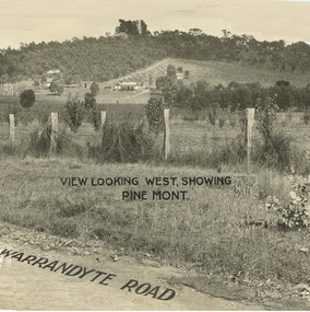
Document - Property Titles, Transfer of Land Act - "Pinemont", Ringwood, Victoria
... 294 and 370 on Plan of Subdivision no.11392 - Anthony Loughnan... Vol 6415 Fol 1282937 Lot 294 on Plan of Subdivision no.11392 ...Folder containing copies of LANDATA documents relating to "Pinemont", Panorama Avenue, Ringwood, Victoria, compiled for potential real estate sales background information purposes. Title Vol 965 Fol 923 Allotment 27B Parish of Warrandyte - James Forbes, dated 30th August, 1876. Title Vol 5236 Fol 1947157 Lots 294 and 370 on Plan of Subdivision no.11392 - Anthony Loughnan, dated 4th March, 1927. Title Vol 6415 Fol 1282937 Lot 294 on Plan of Subdivision no.11392 - Jessie McCracken Rothwell Woodard, dated 9th September, 1940. -
Ringwood and District Historical Society
Legal record - Conditions of Sale (C.E. Carter), Ringwood Electric Railway Estate, Lots 98 and 99, Sale to Tilbury and Albon, 1925
... Esq: Lots 98 and 99, Electric Railway estate, Ringwood Plan... Railway estate, Ringwood Plan of Subdivision 9473, Crown Portion ...Original Particulars and Conditions of Sale document by C.E. Carter & F. H. Patterson & Co, to B.C. Tilbury Esq and A.J.Albon Esq: Lots 98 and 99, Electric Railway estate, Ringwood Plan of Subdivision 9473, Crown Portion 18, Parish of Ringwood. -
 Whitehorse Historical Society Inc.
Document, Land purchase Certificate of Title, 12/11/1913 12:00:00 AM
... Plan of subdivision of land in the Shire of Nunawading... road Plan of subdivision of land in the Shire of Nunawading ...Plan of subdivision of land in the Shire of Nunawading which includes 'Wandinong'.Plan of subdivision of land in the Shire of Nunawading which includes 'Wandinong'. Copy of Certificate of Title of Crown Grant to Janet Emily Hooke, nee Billing, dated 12/11/1913, also purchase of land by J. Woods dated 31/3/1856.Plan of subdivision of land in the Shire of Nunawading which includes 'Wandinong'. haines, william, woods, john, hooke, janet emily, billing, wandinong sanctuary, canterbury road, blackburn, blackburn road -
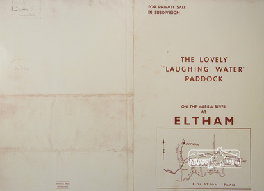 Eltham District Historical Society Inc
Photograph, For Private Sale in Subdivisions; The Lovely "Laughing Water" Paddock on the Yarra River at Eltham
... Collins Street, Melbourne Location plan and subdivision map... Collins Street, Melbourne Location plan and subdivision map ...Private sale of the "Laughing Water" paddock in subdivision; 5 river frontages with weatherboard villa on Lot 8; 6 woodland blocks of 5 and 6 acres. Sole Agent: Edward Haughton, 379 Collins Street, Melbourne Location plan and subdivision mapA3 colour photographic print from digital image of sales brochure and A4 reproduction of price listlaughing waters, edward haughton, real estate agent, eltham -
 Eltham District Historical Society Inc
Postcard - Photograph postcard, Old Bridge, Kaylock's Crossing, Brougham Street, Eltham, c.1912
... . It was one of several east-west streets shown on the subdivision plan.... It was one of several east-west streets shown on the subdivision plan ...Date estimated to be circa 1912 based on the style of printing on the reverse of the card - Kodak Austral paper for real photo postcards, the paper was manufactured c.1908-1914 (See also POSTCARDS ON KODAK PAPER - IS IT POSSIBLE TO "DATE" THEM? http://tps.org.au/bb/viewtopic.php?t=115) Brougham Street was created in Josiah Holloway's 1851 subdivision of Little Eltham. It was one of several east-west streets shown on the subdivision plan as crossing the Diamond Creek. The western part was named Wellington Street on the subdivision plan but was later changed to conform with the name of the eastern part as acknowledgement of the continuity of the street. It is not known when the first bridge was constructed in Brougham Street however it was certainly mentioned at Council’s meeting of 2 June 1884 as being in a dangerous state of repair. This photo (c.1895) of an old bridge shows a very low-level simple log girder bridge crossing the creek at a right angle and so the approaches involved bends in the road alignment. This bridge was generally known as Kaylocks Bridge or Kaylock’s Crossing after the owner of the adjoining land. It was most likely built from around the mid-1850s, or a crossing of some fashion established as Richard George Kaylock, butcher of Little Eltham and his wife Emily Ann settled there in 1854. His property was in Wellington Street (now Brougham Street) and apparently extended across the Diamond Creek. The land on the western side of the creek was farmed, the house being on the eastern side. Kaylock's Bridge formed part of the original coach road to Eltham and in 1922 was described as an "old rustic bridge". Its low level and insubstantial construction made it susceptible to flood damage, necessitating frequent closures until repairs could be carried out. In September 1922, Council called for tenders for a new timber bridge to be constructed at Kaylock’s crossing. An engineering assessment carried out for the Council by Macleod Consulting at the time of the replacement suggested that the construction details indicate that it was in the 1900s, however this dating could possibly have been the result of numerous repairs undertaken over the years to flood damage. The tender was awarded to Mr Weller of Kangaroo Ground who commenced work in February 1923 on a higher-level timber trestle bridge. Work was slowed due to illness of the contractor and the accidental death of a man in March 1923 following the collapse of the bank after he had jumped into a hole that had just been blasted. The bridge was completed around July 1923 at which point the old structure was pulled up, marking what was described in the ‘Advertiser’ newspaper as the passing of an old and well-loved landmark in the district. In April 1924 the approach to Kaylocks bridge was washed away during the heavy flooding that destroyed the Main Road bridge. The western side was repaired, and an extra span was added to the eastern side using timber from the destroyed Main Road bridge. The bridge was again severely damaged four months later in August 1924 When a lack of finances delayed repairs to the Bridge Street bridge in 1931 (also referred to as Obelisk Bridge at the time), traffic had to detour via Brougham Street for some time. Local residents feared that the Bridge Street bridge might never reopen. Kaylocks Bridge was constantly subject to damage by floods. In the 1934 flood it was submerged by two feet of water. In more recent times the bridge was again severely damaged by flooding and repairs made. A new bridge and adjoining footbridge were constructed in 2009.Digital file only Postcards scanned from the collection of Michael Aitken on loan to EDHS, 2 Sep. 2022michael aitken collection, eltham, postcards, bridge, brougham street, diamond creek (creek), kaylocks bridge, wellington street -
 Eltham District Historical Society Inc
Photograph, Old Bridge, Kaylock's Crossing, Brougham Street, Eltham, c.1895
... shown on the subdivision plan as crossing the Diamond Creek... shown on the subdivision plan as crossing the Diamond Creek ...Brougham Street was created in Josiah Holloway's 1851 subdivision of Little Eltham. It was one of several east-west streets shown on the subdivision plan as crossing the Diamond Creek. The western part was named Wellington Street on the subdivision plan but was later changed to conform with the name of the eastern part as acknowledgement of the continuity of the street. It is not known when the first bridge was constructed in Brougham Street however it was certainly mentioned at Council’s meeting of 2 June 1884 as being in a dangerous state of repair. This photo (c.1895) of an old bridge shows a very low-level simple log girder bridge crossing the creek at a right angle and so the approaches involved bends in the road alignment. This bridge was generally known as Kaylocks Bridge or Kaylock’s Crossing after the owner of the adjoining land. It was most likely built from around the mid-1850s, or a crossing of some fashion established as Richard George Kaylock, butcher of Little Eltham and his wife Emily Ann settled there in 1854. His property was in Wellington Street (now Brougham Street) and apparently extended across the Diamond Creek. The land on the western side of the creek was farmed, the house being on the eastern side. Kaylock's Bridge formed part of the original coach road to Eltham and in 1922 was described as an "old rustic bridge". Its low level and insubstantial construction made it susceptible to flood damage, necessitating frequent closures until repairs could be carried out. In September 1922, Council called for tenders for a new timber bridge to be constructed at Kaylock’s crossing. An engineering assessment carried out for the Council by Macleod Consulting at the time of the replacement suggested that the construction details indicate that it was in the 1900s, however this dating could possibly have been the result of numerous repairs undertaken over the years to flood damage. The tender was awarded to Mr Weller of Kangaroo Ground who commenced work in February 1923 on a higher-level timber trestle bridge. Work was slowed due to illness of the contractor and the accidental death of a man in March 1923 following the collapse of the bank after he had jumped into a hole that had just been blasted. The bridge was completed around July 1923 at which point the old structure was pulled up, marking what was described in the ‘Advertiser’ newspaper as the passing of an old and well-loved landmark in the district. In April 1924 the approach to Kaylocks bridge was washed away during the heavy flooding that destroyed the Main Road bridge. The western side was repaired, and an extra span was added to the eastern side using timber from the destroyed Main Road bridge. The bridge was again severely damaged four months later in August 1924 When a lack of finances delayed repairs to the Bridge Street bridge in 1931 (also referred to as Obelisk Bridge at the time), traffic had to detour via Brougham Street for some time. Local residents feared that the Bridge Street bridge might never reopen. Kaylocks Bridge was constantly subject to damage by floods. In the 1934 flood it was submerged by two feet of water. In more recent times the bridge was again severely damaged by flooding and repairs made. A new bridge and adjoining footbridge were constructed in 2009. Part of a slide show presentation "Bridges & Waterways of the Shire" by Russell Yeoman to the 13 September 1989 Society meeting. The presentation included slides of historic photos from the Shire of Eltham Pioneers collections as well as several recent views.Photo of earliest known crossing of the Diamond Creek at brougham StreetPostcard photo printbrougham street, eltham, wellington street, kaylocks bridge, bridge, diamond creek (creek) -
 Whitehorse Historical Society Inc.
Document, Blackburn, 1/08/1995 12:00:00 AM
... on Plan of Subdivision No 56619 fronting on Gordon Crescent near... on Plan of Subdivision No 56619 fronting on Gordon Crescent near ...py of Certificate of Title Vol 8380 Fol 661, Lot 1 on Plan of Subdivision No 56619 fronting on Gordon Crescent near Central Road,Photocopy of Certificate of Title Vol 8380 Fol 661, Lot 1 on Plan of Subdivision No 56619 fronting on Gordon Crescent near Central Road, Blackburn to Finlay Urquhart, 7 November 1962; with plans from Vol 6839 Fol 696 from which title is derived.py of Certificate of Title Vol 8380 Fol 661, Lot 1 on Plan of Subdivision No 56619 fronting on Gordon Crescent near Central Road,land subdivision, gordon crescent, blackburn, central road, urquhart, finlay, newman, jeffrey william forbes, valerie, jones, ian edward swanson, joan mary, strickland, kenneth william, wilma dawn -
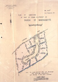 Ringwood and District Historical Society
Document - Folder, Pembroke Estate Subdivsion, Ringwood, Victoria - 1964
... Manilla folder containing certified copy of Plan... Carter - Carter Real Estate - "Vendor - Dale, Plan of Subdivision... Carter - Carter Real Estate - "Vendor - Dale, Plan of Subdivision ...Manilla folder containing certified copy of Plan of Subdivision dated 2nd September, 1964 - Part of Crown Allotment 29 Parish of Warrandyte, and separate A4 size copy of plan with handwritten 1966 pricing notations. Subdivision includes allotments on Pembroke Court off Loughnans Road, Ringwood.Surveyors - Kirkpatrick & Webber, Civil Engineers & Town Planners, 225 Maroondah Highway, Ringwood, Telephone 8700321. Agents - C.E. Carter & Son RESI., 126 Whitehorse Road, Ringwood (Phone) 87-6024, 87-6830, 870-2519. Folder covernote by Richard Carter - Carter Real Estate - "Vendor - Dale, Plan of Subdivision 68868, sold 23 July 1966." -
 Greensborough Historical Society
Certificate of Title, Certificate of Title Vol. 3182 Fol. 302, 15/02/1907
... , fruitgrower, 14 acres being Lots 7, 8 and 22 on Plan of subdivision... of Greensborough, fruitgrower, 14 acres being Lots 7, 8 and 22 on Plan ...Title in the name of Joseph Laidlay of Greensborough, fruitgrower, 14 acres being Lots 7, 8 and 22 on Plan of subdivision 4759, part of Crown portion 17, Parish of Keelbundora County of Bourke, dated 15th February 1907. Northern boundary Greensborough (now Grimshaw) Road, Eastern boundary Henry Street.1 p. colour copy of Titlegreensborough, grimshaw street greensborough, henry street greensborough, joseph laidlay -
![Map, Plan of Subdivision of Crown Portion 23 & parts 24-25, Parish of Korkuperrimul [1900s?]](/media/collectors/5e461d8021ea67224c82f2a1/items/675fe058304668462205d4fb/item-media/675fe0ef304668462205d7d6/item-fit-380x285.jpg) Bacchus Marsh & District Historical Society
Bacchus Marsh & District Historical SocietyMap, Plan of Subdivision of Crown Portion 23 & parts 24-25, Parish of Korkuperrimul [1900s?]
... Plan of Subdivision of Crown Portion 23 & parts 24-25... directions from the township area. The date of the subdivision.... Plan of Subdivision of Crown Portion 23 & parts 24-25, Parish ...The Parish of Korkuperrimul includes a significant section of the township of Bacchus Marsh and extends in western and northern directions from the township area. The date of the subdivision indicated on this plan has not been established. The engineer's stamp on the drawing shows the firm of Muntz and Muntz who were operating under that name in the early part of the 20th century.A single page paper map showing 20 blocks of land for sale in the Parish of Korkuperrimul. Scale 100 feet to 1 inch. The map is pasted into a bound volume containing 76 maps or plans in total. High resolution digital image stored on BMDHS computer network. Stamped: 'Muntz & Muntz Civil Engineers, Architects & Surveyors, Trustees Chambers ?? Cor Collins Street and Bank Placeland sales bacchus marsh, bacchus marsh victoria maps, land sales korkuperrimul parish -
Whitehorse Historical Society Inc.
Map, Springfield Road, Blackburn, 1924
... Plan of subdivision, parts of Crown Portions 73 and 74... Square Shopping Centre Plan of subdivision, parts of Crown ...Plan of subdivision, parts of Crown Portions 73 and 74, parish of Nunawading, County of Bourke.Plan of subdivision, parts of Crown Portions 73 and 74, parish of Nunawading, County of Bourke. Passed by MMBW 24 May 1924. Subdivision not implemented. Originally owned by Leonard Sherwin Bayley, then by Edward Henry Pearce, then by Ron Pearce. Part compulsorily acquired as site for Blackburn High School. With historical notes by Ron Pearce.Plan of subdivision, parts of Crown Portions 73 and 74, parish of Nunawading, County of Bourke. bayley, leonard sherwin, pearce, edward h, pearce, ronald harry, orchards, blackburn high school, north blackburn square shopping centre -
 Bendigo Historical Society Inc.
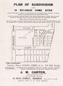
Document - RANDALL COLLECTION: PLAN OF SUBDIVISION OF 18 SPLENDID HOME SITES, Sat. 18th May 1929
... RANDALL COLLECTION: PLAN OF SUBDIVISION OF 18 SPLENDID HOME...Document, Plan of Subdivision of 18 Splendid Home Sites... DOCUMENT J.B.Ross, Print, Bendigo Document, Plan of Subdivision ...Document, Plan of Subdivision of 18 Splendid Home Sites. Having frontages to Albion and Clark Streets and Grand View Cresent, between Condon and Ligar Streets, just pass Neale Street.Title Certificate: Solicitors, Messrs. Cohen, Kirby & Co, Pall Mall, Bendigo. J.W.Carter 61 Bull Street , Bendigo, ''The Agent Who Knows How''.J.B.Ross, Print, Bendigodocument -
 Bendigo Historical Society Inc.
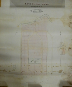
Plan - MARKS COLLECTION: PLAN OF G. LANSELL'S GOVERNOR'S PARK, TOORAK
... of plan Yarra River, on bottom Toorak Road, Plan shows subdivision... of plan Yarra River, on bottom Toorak Road, Plan shows subdivision ...Plan (tightly rolled) drawn on heavy paper mounted on fabric. On top of plan printed 'Governor's Park Toorak, late Vice-Regal Estate, the property of G. Lansell Esq' On top of plan Yarra River, on bottom Toorak Road, Plan shows subdivision, in centre of which is drawn outline of 8 acres containing the 'Mansion and Grounds'.bendigo, hospital -
 Bendigo Historical Society Inc.
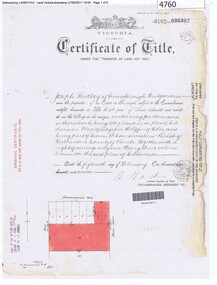
Document - H.A. & S.R. WILKINSON COLLECTION: CONTRACT OF SALE
... Courton plan of subdivision no. B80611 and lot 1 on plan... of subdivision no. B80611 and lot 1 on plan of subdivision no. 51583 ...Contract of sale of real estate dated 22nd December, 1960 between Mr. W. B. Nicholls (vendor) and Mr. C. W. & Mrs. F. L. Silk (purchaser). Solicitor for vendor: Messrs Hyett, Willis & Hyett, Bull Street, Bendigo. Solicitor for purchaser: Messrs. Tatchell, Dunlop, Smalloy & Balmer, Williamson Street, Bendigo. Property: vacant land corner Derna Court and Poplar Street, Golden Square, being lots 20,21,22,23,24, 25, 26 and 27 fronting Derna Courton plan of subdivision no. B80611 and lot 1 on plan of subdivision no. 51583 lodged in the office of titles and being part of Crown allotment 11 section 24A at Bendigo described in Crown grant volume 8217 folio 121. Price 4,900 pounds .organization, business, h.a. & s.r wilkinson real estate -
 Bendigo Historical Society Inc.
Document - BUSH COLLECTION: PLANS PERTAINING TO LAND OF S. A. BUSH
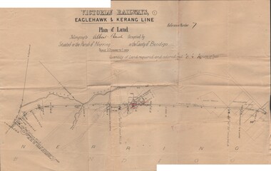
... A: Plan of subdivision of Allots 6, 7, 8, 15 & 16, Sec. 62C... PERSON Individual bush collection - personal A: Plan ...A: Plan of subdivision of Allots 6, 7, 8, 15 & 16, Sec. 62C, City of Bendigo (The Property of Albert Bush, Esq.) - Plan is torn in half forming two pieces (see 'Condition'. Pinned note attached to one piece. B: Victoria Railways, Eaglehawk & Kerang Line (Albert Bush land, Parish of Nerring, County of Bendigo.person, individual, bush collection - personal -
Clunes Museum
Map - PLAN / MAP
... , STAMPED BOROUGH OF CLUNES .2 PLAN OF SUBDIVISION OF PART... OF CLUNES, COUNTY OF TALBOT, STAMPED BOROUGH OF CLUNES .2 PLAN ....1 MAP, TOWN OF CLUNES, PARISH OF CLUNES, COUNTY OF TALBOT, STAMPED BOROUGH OF CLUNES .2 PLAN OF SUBDIVISION OF PART OF CLUNES COMMON, BOROUGH OF CLUNES, PARISH OF CLUNES,COUNTY OF TALBOT. P. CAMPBELL. ASSISTANT SURVEYOR, MARCH 1904 ON RIGHT HAND BOTTOM CORNER C71/1 CLUNES COMMON. MARKED: CHARTED R.L.A.7/2/57.1 PHOTO LITHOGRAPHED. DEPARTMENT OF LANDS AND SURVEY, MELBOURNE .2 PHOTO LITHOGRAPHED AT THE DEP. OF LANDS AND SURVEY, MELBOURNE PRICE 1/- 10.11.08map town of clunes, borough of clunes, parish of clunes, county of talbot -
 Ringwood and District Historical Society
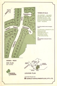
Flyer, Land Sale Advertisement - Banool Gardens Subdivision, Ringwood, Vic. c.1985
... Double-sided advertisement for Banool Gardens subdivision... subdivision with site plan, location plan, terms of sale, and summary ...Double-sided advertisement for Banool Gardens subdivision with site plan, location plan, terms of sale, and summary of homesite features and local services & facilities. Subdivision includes Wonga Road, Hamilton Drive, Tinworth Place, Andrea Parade and Benjamin Court, Ringwood North. Managing agent - Ollson Real Estate Pty. Ltd., North Croydon Shopping Plaza, Maroondah Highway. Croydon, Vic. 3136. Telephone 726 9988 After Hours 876 4190. Project by Darnley Developments (Vic.) Pty. Ltd. Accompanying handwritten notation by Richard Carter R.E.S.I. - "Part of original Banool property (Mahon, sold to Stallman, sold to McMahon, sold to Len Macley etc etc). Hamilton Drive named after Lynn Hamilton McMahon, Tinworth Place after his son-in-law, David Tinworth".