Showing 429 items
matching the diggings
-
 Bendigo Historical Society Inc.
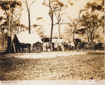
Photograph - SANDHURST, c1867
Sepia photograph: Diggings Myers Creek. Slab huts on left side. Man standing in front of hut, barrels and timber outside hut. Carriage with two horses, on right buck board and one horse, horse and cart on left. Discovery of gold at Myers Creek 1867, vic. Australia. Letter from Kerry Carroll included.Batchelderplace, land, mining, kerry carroll (for dolly carroll), 9 brooke street, eaglemont vic 3084 -
 Bendigo Historical Society Inc.
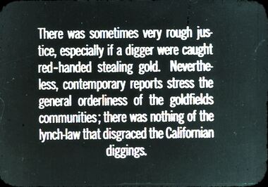
Slide - DIGGERS & MINING. THE DIGGING - THE DIGGERS, c1800s
Diggers & Mining. The Digging - The Diggers. Slide; There was sometimes very fought justice, especially if a digger were caught red-handed stealing gold. Never the-less, contemporary reports stress the general orderliness of the goldfields communities; there was nothing of the lynch-law that disgraced the Californian diggings. Markings: 63 994.LIF:6. Used as a teaching aid.hanimounteducation, tertiary, goldfields -
 Bendigo Historical Society Inc.
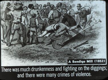
Slide - DIGGERS & MINING. THE DIGGING - THE DIGGERS, c1850s
Diggers & Mining. The Digging - The Diggers. Slide reads; A Bendigo Mill (1852). There was much drunkenness and fighting on the diggings; and there were many crimes of violence. Slide shows a tent store in background, in foreground a man falling over a wheel barrow, and many men in the picture are fighting, with spectators. Markings: -- 994.LIF:6. Used as a teaching aid.hanimounteducation, tertiary, goldfields -
 Victorian Interpretive Projects Inc.
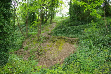
Photograph - Colour, Clare Gervasoni, Drystone wall at White Flat, Ballarat, 07/10/2012
White Flat was an early gold diggings. As early as 1856 the White Flat Drainage and Mining Co. constructed water races, drained the swampy land, and changed the course of the Yarrowee Creek. This may be remnants of that work. See http://bih.ballarat.edu.au/index.php/White_Flat_Drainage_and_Mining_Co.#cite_note-0 Five colour digital imaged of a bluestone drystone wall at White Flat, Ballarat. The drystone wall is on the steep embankment between Hickman Street and Armstrong Street South. ballarat, white flat, white flat sports ground, hickman street, south street, armstong street, oval, cricket, football, white flat drainage, yarrowee creek drystone, bluestone -
 The Beechworth Burke Museum
Photograph, c.1863
Taken in Beechworth, this photograph depicts Albert road bisecting the Spring Creek Diggings. The foreground of the photograph features a small bridge, while in the background, right-hand-side, Benevolent Hospital can be seen. In the centre of the photograph can be seen a horse and cart travelling along the road. This photograph shows historical and research value in its depiction of Beechworth in the late 1800s. It features a key historical site, the Benevolent Hospital, as well providing a historical look at a street that operates in Beechworth in the present day.Black and white, rectangular photograph printed on matt photographic paper, unmountedReverse: PH 238 / 1997.2462 / Albert Road . 1863 . 1800s beechworth, 1860s beechworth, beechworth, spring creek, benevolent asylum, albert road -
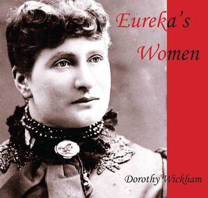 Ballarat Heritage Services
Book, 'Eureka's Women' by Dorothy Wickham
Eureka's Women was published by BHS Publishing and written by Dorothy Wickham. The book tells wonderful stories about the women who were at Eureka. Wickham wrote a PhD on the Women at Ballarat Goldfields, and a book Women of the Diggings: Ballarat 1854, published by Ballarat Heritage Services in 2004.An illustrated booklet on women associated with Eureka.eureka stockade, women, dorothy wickham, eureka's women -
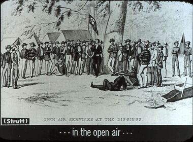 Bendigo Historical Society Inc.
Slide - DIGGERS & MINING. THE DIGGING - THE DIGGERS, c1850s
Diggers & Mining. The Digging - The Diggers. Slide: (Strutt) OPEN AIR SERVICES AT THE DIGGINGS . . . In the open air . . . Slide depicts miners standing around a tree, a preacher at the tree giving a sermon, tents (one tent has mining flag on it) and trees in background, cradle, shovel and pick in foreground. Markings: 72 994.LIF:6. Used as a teaching aid.hanimounteducation, tertiary, goldfields -
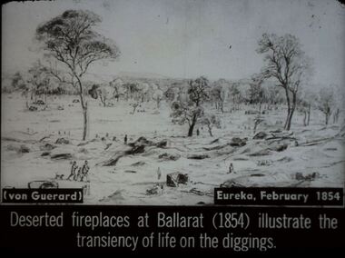 Bendigo Historical Society Inc.
Slide - DIGGERS & MINING. DIGGERS AND MINERS, c1854
Diggers & Mining. Diggers and miners. (von Guerard) Eureka, February, 1854. Deserted fireplaces at Ballarat (1854) illustrate the transiency of life on the diggings. Slide shows old mining site with holes piles of dirt and fire places. Only a few miners are left, some appear to be leaving. Markings: 37 994:LIF I. Used as a teaching aid.hanimounteducation, tertiary, goldfields -
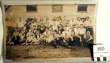
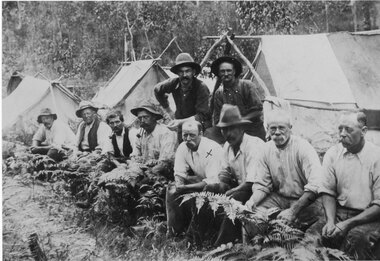 Halls Gap & Grampians Historical Society
Photograph - Sepia, C 1909
Grampians halls Gap at Stoney Creek Dredge. The site of the Stoney Creek diggings was in the upper catchment area of the creek, beside Silverband Road. For further information see: 'Bridging the Gap' by Ida Stanton, p. 49 and 'Victoria's Wonderland' by Halls Gap and Grampians Historical Society, p. 41.Photo shows eight men seated, two standing, 3 tents in background. 2nd right Alfred D'Alton 4th Right James Oliverwater supplies, d'alton, water supplies, channels -
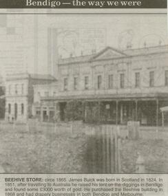 Bendigo Historical Society Inc.
Newspaper - JENNY FOLEY COLLECTION: BEEHIVE
Bendigo Advertiser ''The way we were'' from 2000. Beehive store: circa 1865. James Buick was born in Scotland in 1824. In 1851, after travelling to Australia he raised his tent on the diggings in Bendigo and found some 3,000 pounds worth of gold.. He purchased the Beehive building in 1868 and had drapery businesses in both Bendigo and Melbourne. The clip is in a folder.newspaper, bendigo advertiser, the way we were -
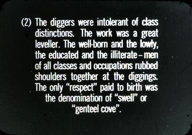 Bendigo Historical Society Inc.
Slide - DIGGERS & MINING. THE DIGGING - THE DIGGERS, c1800s
Diggers & Mining. The Digging - The Diggers. Slide reads: (2) The diggers were intolerant of class distinctions. The work was a great leveller. The well-born and the lowly, the educated and the illiterate - men of all classes and occupations rubbed shoulders together at the diggings. The only ''respect'' paid to birth was the denomination of ''swell'' or ''genteel cove''. Markings: 70 994.LIF:6. Used as a teaching aid.hanimounteducation, tertiary, goldfields -
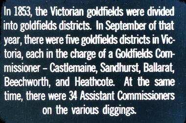 Bendigo Historical Society Inc.
Slide - DIGGERS & MINING. THE GOLD LICENCE, c1853
Diggers & Mining. The gold licence. The Government Camp. In 1853, the Victorian goldfields were divided into goldfields districts. In September of that year, there were five goldfields districts in Victoria, each in the charge of a Goldfields Commissioner - Castlemaine, Sandhurst, Ballarat, Beechworth, and Heathcote. At the same time, there were 34 Assistant Commissioners on the various diggings. Markings: 30 994.LIF. 4. Used as a teaching aid.hanimounteducation, tertiary, goldfields -
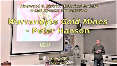 Ringwood and District Historical Society
Mixed media - Video, RDHS Guest Speaker Presentation - "Warrandyte Gold Mines" - Peter Hanson
Digitised video (2.73GB). Duration: 58 minutes. Recorded July, 2024. (Video is available for viewing at Ringwood & District Historical Society Archives by appointment)Guest Speaker, Peter Hanson grew up in Warrandyte surrounded by signs of gold mining activities including in his own back yard. In this presentation, Peter talks about the numerous diggings in the area, with images, maps and drawings of the mines, tunnels, shafts and structures above and below ground. -
 Eltham District Historical Society Inc
Document - Folder, Murphy, James and descendants
James Murphy was a mining surveyor involved with the Caledonia diggings. Contents Note from Ray Blake, 26 April 2000: Ms Murphy said her people had traditionally owned all of inner Melbourne, north to the Great Divide, West to Werribee River, East to Mt Baw Baw, South to Mordialloc Creek.Newspaper clippings, A4 photocopies, etcjames murphy -
 Myrtleford and District Historical Society
Hop Growers Photograph, "Panlook Boys, 1934"
The photograph represents the migratory labour force involved in hop growing, the major farm activity on "Panlook's Hop Gardens", Eurobin in 1934. William Panlook a descendant of a Chinese storekeeper on the Buckland Diggings, had originally commenced tobacco growing at the location until devastating frosts and unreliable tobacco prices brought a change in land use. The photograph represents the transition that occurred from tobacco to hops cultivation in the early 1930s. It is now a permanent feature of the farming landscape at Eurobin. It depicts the reliance on migratory seasonal labour and the importance of local expertise, some of Chinese descent. A sepia-coloured photograph of 30 hop pickers.Inscription: "The Panlook Boys, 1934"hop growing. panlooks hop gardens. eurobin -
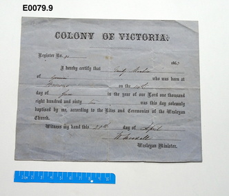 Uniting Church Archives - Synod of Victoria
Certificate - Baptismal certifcate, Register no 91, 1863
Grey paper baptismal certificate for the Colony of Victoria, 1863. Register No 91.non-fiction -
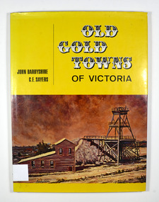 Marysville & District Historical Society
Book, Old Gold Towns of Victoria, 1970
Histories of the old gold towns in VictoriaHardback. Yellow dust cover. Front of jacket illustration-The Diggings, Ballarat. The poppet head, battery house, and mullock heap are typical of an old gold mine, and have been restored on Sovereign Hill over the old North Normandy mine. Back of jacket-The Bend in the Road, at Clunes. Inside both front and back cover is a drawn map of Victoria showing all the towns mentioned in the book. Stamp of the Marysville & District Historical Society Inc / P.O. Box 22 / Marysville 3779 Signature of H M Olivergold town, victoria, australia, history -
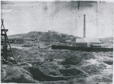 Bendigo Historical Society Inc.
Photograph - MINING LANDSCAPE, 1861
black and white photo: alluvial diggings in foreground, wheelbarrow, centre field stone building with galvanised iron roof with chimney at rear. 2 stascks of 6 foot timber for boiler. Headframe in front. Man standing under shelter near head frame. Midground, left tank of vertical plants. Hill with 5 whims to rear. A. frame and timber structure at centre left, mullock dumps.batchelderplace, landscape view, mining -
Clunes Museum
Work on paper - LEAFLET, 2001
During these celebrations the launch was held of the book "16 Tons of Gold; A History of Port Phillip Mine by author John Woodland. Guests were informed of the dress code for the Colonial Ball .1 A4 buff coloured, printed invitation to 150th Discovery of Gold Celebrations on July 1, 2001 .2 School of Mines Roster for entire week of 150th Discovery of Gold Celebrations .3 Document contains information of the Clunes Colonial Ball held to commemorate 150th Discovery of Gold .4 Invitation to the Miners Walk from Ascot to Clunes Diggings Sunday July 1 2001150th celebrations, school of mines roster 2001, clunes colonial ball guest information, discovery of gold celebration -
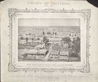 Bendigo Historical Society Inc.
Photograph - DILLON-SHALLARD COLLECTION: VIEWS OF BENDIGO
Views of Bendigo No.41. Scene Taken from St Paul's Tower Looking Eastward. The Free Methodist church. This view represents the locality of the Back Creek gold diggings, and tough at present almost deserted, was once a scene of activity; in consequences of the rich patches of alluvial ground it contained. Photo by N.J. Caire Sandhurst. Casey&Wenborn's Print. On the back a stamp of Ray Dalton BendigoN.J. Cairne -
 Bendigo Historical Society Inc.
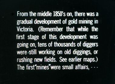
Slide - DIGGERS & MINING. DIGGERS AND MINERS, c1850s
Diggers & Mining. Diggers and miners. From the middle 1850's on, there was a gradual development of gold mining in Victoria. (Remember that while the first stage of this, development was going on, tens of thousands of diggers were still working on old diggings, or rushing new fields. See earlier maps.) The first ''mines'' were small affairs, - - - Markings: 25 994:LIF I. Used as a teaching aid.hanimounteducation, tertiary, goldfields -
 Bendigo Historical Society Inc.
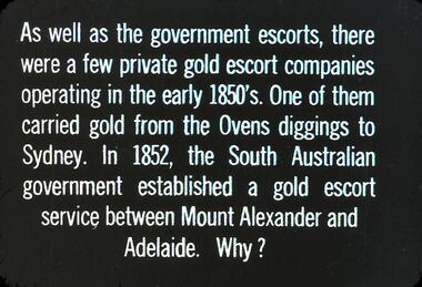
Slide - DIGGERS & MINING. THE GOLD LICENCE, c1850s
Diggers & Mining. The gold licence. The Government Camp. As well as government escorts, there were a few private gold escort companies operating in the early 1850s. One of them carried gold from the Ovens diggings to Sydney. In 1852, the South Australian government established a gold escort service between Mount Alexander and Adelaide. Why? Markings: 25 994.LIF. 4. Used as a teaching aid.hanimounteducation, tertiary, goldfields -
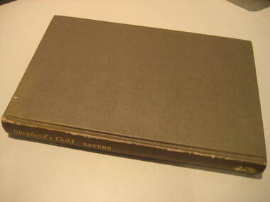 Federation University Historical Collection
Book, C.E. Sayers, Shepherd's Gold: The Story of Stawell, 1966 (exact)
One of the 6 University of Ballarat campuses is at Stawell.Grey hard covered book of 194 pages covering the history of Stawell, Victoria. Contents include Gold, squatters, Ayreys of Warranooke, Diggings, Reefs, Local Government, Road District, Shire, Borough, Town, Hospital, schools, Churches, Growth of Settlement, Claim Jumps, Sheep, Farming, Water, Grampians, Magdala, Callawadda, Deap Lead, Glenorchi, Great Western, Green's Creek, Marnoo, Wal Wal.education, religion, stawell victoria, stawell -
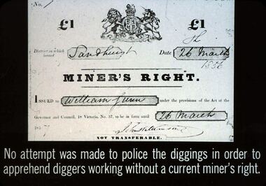 Bendigo Historical Society Inc.
Slide - DIGGERS & MINING. THE GOLD LICENCE, 26 Mar 1856
Diggers & Mining. The gold licence. The Government Camp. Shows a copy of the 1 pound Miner's Right, issued in Sandhurst on 26 March 1856, issued to William Lunn, John Williamson and signed 26 March 1857. No attempt was made to police the diggings in order to apprehend diggers working without a current miner's right. (Note the discrepancy in the years) Markings: 42 994.LIF. 4. Used as a teaching aid.hanimounteducation, tertiary, goldfields -
 Hymettus Cottage & Garden Ballarat
Photograph, Church group, 14/06/2020
This group of buildings all of which served as churches at different periods is one of the best visual demonstrations of the rapid growth of Ballarat caused by the boom years of the gold rush following the initial alluvial diggings of the 1850s. The smallest church was built in 1861 followed by the next built in 1867 and finally the construction of the grand church on the corner of Neil and Macarthur streets Soldiers' Hill in the 1890s.methodist church, uniting church, soldiers hill, ballarat. -
![View of the Township of Mt. Blackwood / [by] Nicholas Caire, circa 1876](/media/collectors/550653872162f11fb04854aa/items/57830cfbd0cdd1176c424e00/item-media/57830d7ad0cdd1176c428423/item-fit-380x285.jpg) Kew Historical Society Inc
Kew Historical Society IncPhotograph, Anglo-Australasian Photographic Company, View of the Township of Mt. Blackwood, c. 1876
Nicholas Caire was born on Guernsey in the Channel Islands in 1837. He arrived in Adelaide with his parents in about 1860. In 1867, following photographic journeys in Gippsland, he opened a studio in Adelaide. From 1870 to 1876 he lived and worked in Talbot in Central Victoria. In 1876 he purchased T. F. Chuck's studios in the Royal Arcade Melbourne. In 1885, following the introduction of dry plate photography, he began a series of landscape series, which were commercially successful. As a photographer, he travelled extensively through Victoria, photographing places few of his contemporaries had previously seen. He died in 1918. Reference: Jack Cato, 'Caire, Nicholas John (1837–1918)', Australian Dictionary of Biography.An original, rare photograph from the series 'Views of Victoria: General Series' by the photographer, Nicholas Caire (1837-1918). The series of 60 photographs that comprise the series was issued c. 1876 and reinforced a neo-Romantic view of the Australian landscape to which a growing nationalist movement would respond. Nicholas Caire was active as a photographer in Australia from 1858 until his death in 1918. His vision of the Australian bush and pioneer life had a counterpart in the works of Henry Lawson and other nationalist poets, authors and painters.‘View of the Township of Mt. Blackwood’ : Views of Victoria (General Series) No.42 : Albumen silver photograph | Photo on card with Title and Description on reverse | Mounted 24 x 30 cm; Photo 12 x 17 cm.On Reverse: ‘The locality which this illustration represents was formerly known as the Blackwood Forest, and has been the scene of considerable mining activity. The shallow alluvial diggings of the early days have given place to the deep sinking in search of reefs. This scene is characteristic of the wild appearance which many of the inland townships of Victoria represent.’nicholas caire (1837-1918), blackwood (vic), mount blackwood, landscape photography - victoria -
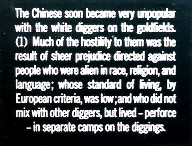 Bendigo Historical Society Inc.
Slide - DIGGERS & MINING. GOLD, c1850s
Diggers & Mining. Gold. The Chinese soon became very unpopular with the white diggers on the goldfields. (1) Much of the hostility to them was the result of sheer prejudice directed against people who were alien in race, religion, and language; whose standard of living, by European criteria, was low; and who did not mix with other diggers, but lived - preforce - in separate camps in the diggings. Markings: 22 994.GOL. Used as a teaching aid.hanimounteducation, tertiary, goldfields -
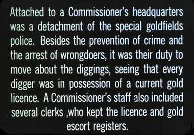 Bendigo Historical Society Inc.
Slide - DIGGERS & MINING. THE GOLD LICENCE, c1850s
Diggers & Mining. The gold licence. The Government Camp. Slide: Attached to a Commissioner's headquarters was a detachment to the special goldfields police. Besides the prevention of crime and the arrest of wrongdoers, it was their duty to move about the diggings, seeing that every digger was in possession of a current gold licence. A commissioner's staff also included several clerks, who kept the licence and gold escort registers. Markings: 13 994.LIF. 4. Used as a teaching aid.hanimounteducation, tertiary, goldfields -
 Bendigo Historical Society Inc.
Slide - DIGGERS & MINING. DIGGERS AND MINING
Diggers & Mining: Diggers & Mining.Slide reads: And nearly all of the illustrations we have been able to find depict only the three main fields of this early period - Ballarat, Castlemaine, and Bendigo. However, the picture they give may be taken as fairly typical of the other diggings of the time, and, in some respects, of the early stages in the development of other fields later in the gold era. Markings: 55/ 994:LIF 1. Used as a teaching aid.hanimounteducation, tertiary, diggers & miners -
Tarnagulla History Archive
Telegram, circa 1862
A large lot of papers, including this and other telegrams, were apparently found in the ceiling cavity of the Sandy Creek/Tarnagulla Post and Telegraph Office in the later 20th Century, during building works. Donald Clark Collection. Telegram sent from Sandy Creek / Tarnagulla Telegraph Office. From John Papineau (on behalf of E.N. Francis) to Mrs Giradini, Sandhurst. Text reads 'Your brother and his mate bought a horse at Cochrane's Diggings which had been stolen and the police found it in their possession. They are innocent but I have to bring witnesses a long distance. I shall defend them in expectation of securing the five pounds from you'.