Showing 274 items matching "tourist map"
-
 Victorian Railway History Library
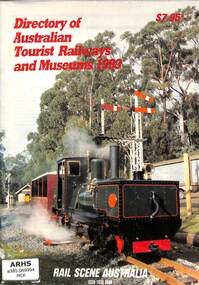
Book, Bob McKillop, Directory of Australian Tourist Railways and Museums 1993, 1993
A list of Australian tourist railways and museums in 1993Index, ill, maps, p.63.non-fictionA list of Australian tourist railways and museums in 1993railway and tramway preservation - australia, tourist railways and museums - australia -
 Melbourne Tram Museum
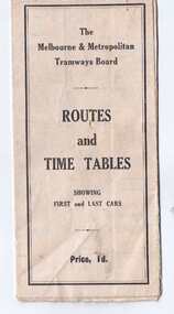
Map, Melbourne & Metropolitan Tramways Board (MMTB), "Routes and Time tables showing first and last cars", c1927
... Trams tramways Map MMTB Tourist Trams Y Class VR Cable ...Folded map (5 x 3) by Melbourne and Metropolitan Tramways Board, c1927, of Melbourne tramways, showing tram routes (cable, electric and VR), railway lines, major points of interest and major streets. Titled "Routes and Time tables showing first and last cars". On rear shows maps of lines for the Eastern, Southern, Connection to Beaches and the Essendon, Maribyrnong and West Coburg lines. Dated c1927, shows the St Kilda Road lines to electric. On the bottom right hand corner has a reference to the Tramway Tourist Car - and the tours it does. (Reg Item 800 dated March 1927, shows the tram under construction). Second copy from Keith Kings Collection - in poor condition - added 10/8/2017The VR line has various hand written notations indicating it.trams, tramways, map, mmtb, tourist trams, y class, vr, cable trams, routes, timetables -
 Victorian Railway History Library
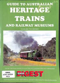
Book, Robert F. McKillop, Guide to Australian Heritage Railways & Museums Year 2000, 1999
A list of heritage railways and museums in Australia in 2000ills, maps, p.144.non-fictionA list of heritage railways and museums in Australia in 2000railway and tramway preservation - australia, tourist railways and museums - australia -
 Victorian Railway History Library
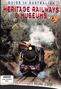
Book, Robert F. McKillop, Guide to Australian Heritage Railways & Museums 6th Edition, 1997
A list of heritage railways and museums in Australia in 2000index, ills, maps, p.143.non-fictionA list of heritage railways and museums in Australia in 2000railway and tramway preservation - australia, tourist railways and museums - australia -
 Victorian Railway History Library
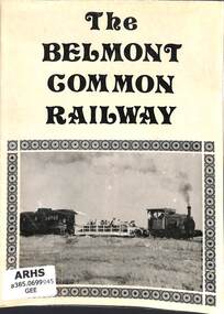
Booklet, Geelong Steam Preservation Society, The Belmont Common Railway, 1969
Illustrated history of the Belmont Common Railway in Geelong & a description of their locomotives & rollingstockill, maps, p.6.non-fictionIllustrated history of the Belmont Common Railway in Geelong & a description of their locomotives & rollingstockthe belmont common railway - geelong, tourist railways and museums - australia -
 Victorian Railway History Library
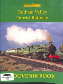
Book, John Purcell, Hotham Valley Tourist Railway - Souvenir Book, 1991
The history and rollingstock collection of the Hotham Valley Tourist Railway in Pinjarra Western Australiaill, map, p.44.non-fictionThe history and rollingstock collection of the Hotham Valley Tourist Railway in Pinjarra Western Australiahotham valley tourist railway - western australia, tourist railways and museums - australia -
 Victorian Railway History Library
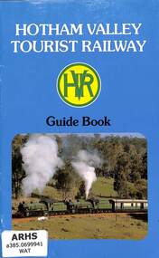
Book, L. G. Watson, Hotham Valley Tourist Railway - Guide Book, 1979
The history and rollingstock collection of the Hotham Valley Tourist Railway in Pinjarra Western Australiaill, maps, p.20.non-fictionThe history and rollingstock collection of the Hotham Valley Tourist Railway in Pinjarra Western Australiarailway and tramway preservation - australia, hotham valley tourist railway - western australia -
 Victorian Railway History Library
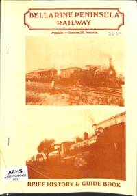
Booklet, Michael Menzies, Bellarine Peninsula Railway - Brief History & Guide Book, 1990
Illustrated history of the Bellarine Peninsula Railway and a guide to its locomotives & rollingstock in 1990ill, maps, p.14.non-fictionIllustrated history of the Bellarine Peninsula Railway and a guide to its locomotives & rollingstock in 1990the bellarine peninsula railway - queenscliff, tourist railways and museums - australia -
 Victorian Railway History Library
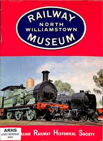
Booklet, Australian Railway Historical Society (Victorian Division), Railway Museum - North Williamstown, 1964
An illustrated guide to the locomotive & rollingstock collection of the Australian Railway Historical Society (Vic Division) Railway Museum in 1968.ill, maps, p.31.non-fictionAn illustrated guide to the locomotive & rollingstock collection of the Australian Railway Historical Society (Vic Division) Railway Museum in 1968.arhs railway museum north williamstown - victoria, tourist railways and museums - australia -
 Victorian Railway History Library
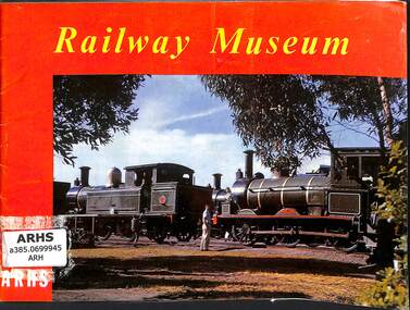
Booklet, Australian Railway Historical Society (Victorian Division), Railway Museum - revised edition, 1964
An illustrated guide to the locomotive & rollingstock collection of the Australian Railway Historical Society (Vic Division) Railway Museum in 1964.ill, maps, p.23.non-fictionAn illustrated guide to the locomotive & rollingstock collection of the Australian Railway Historical Society (Vic Division) Railway Museum in 1964.arhs railway museum north williamstown - victoria, tourist railways and museums - australia -
 Victorian Railway History Library
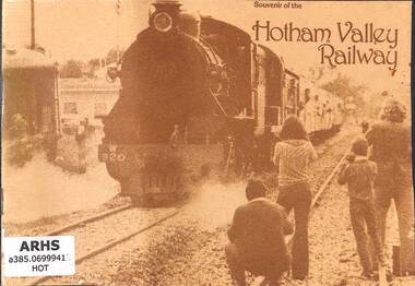
Book, Hotham Valley Railway, Souvenir of the Hotham Valley Railway, 1979
A short history and rollingstock collection of the Hotham Valley Railway in Pinjarra Western Australiaill, maps, p.12.non-fictionA short history and rollingstock collection of the Hotham Valley Railway in Pinjarra Western Australiarailway and tramway preservation - australia, hotham valley tourist railway - western australia -
 Victorian Railway History Library
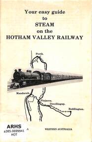
Booklet, Hotham Valley Railway, Your easy guide to Steam on the Hotham Valley Railway, ????
A description of the Hotham Valley Tourist Railway from Pinjarra to Boddington and the rollingstock and locomotives.ill, maps, p.7.non-fictionA description of the Hotham Valley Tourist Railway from Pinjarra to Boddington and the rollingstock and locomotives.hotham valley tourist railway - western australia, tourist railways and museums - australia -
 Victorian Railway History Library
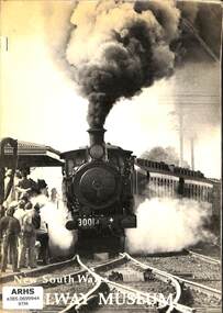
Book, New South Wales Rail Transport Museum, New South Wales Railway Museum, 1974
A submission to the Government of New South Railways about the future of the New South Wales Rail Transport Museum at Enfield Sydney NSWmaps, p.55.non-fictionA submission to the Government of New South Railways about the future of the New South Wales Rail Transport Museum at Enfield Sydney NSWenfield railway museum - sydney nsw, tourist railways and museums - australia -
 Victorian Railway History Library
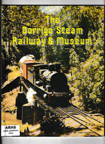
Book, Dr John Kramer, The Dorrigo Steam Railway & Museum, 1987
Details of the locomotives and rollingstock at the Dorrigo Steam Railway & Museum in Northern NSWill, maps, p.72.non-fictionDetails of the locomotives and rollingstock at the Dorrigo Steam Railway & Museum in Northern NSWdorrigo steam railway & museum - nsw, tourist railways and museums - australia -
 Victorian Railway History Library
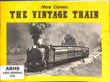
Book, Vintage Trains Publications, Here Comes The Vintage Train, 1977
An illustrated history of the Vintage train operations in Victora.ill, maps, p.32.non-fictionAn illustrated history of the Vintage train operations in Victora.the vintage train - victoria, tourist railways and museums - australia -
 Victorian Railway History Library
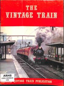
Book, Vintage Trains Publications, The Vintage Train, 1974
An illustrated history of the Vintage train operations in Victora.ill, maps, p.56.non-fictionAn illustrated history of the Vintage train operations in Victora.the vintage train - victoria, tourist railways and museums - australia -
 Victorian Railway History Library
Booklet, Australian Railway Historical Society (Victorian Division), Railway Museum - Australian Railway Historical Society Victorian Division, 1964
An illustrated guide to the locomotive & rollingstock collection of the Australian Railway Historical Society (Vic Division) Railway Museum in 1962.ill, maps, p.31.non-fictionAn illustrated guide to the locomotive & rollingstock collection of the Australian Railway Historical Society (Vic Division) Railway Museum in 1962.arhs railway museum north williamstown - victoria, tourist railways and museums - australia -
 Narre Warren and District Family History Group
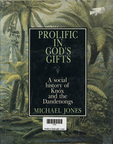
Book, MA Jones, Prolific in God's gifts : a social history of Knox and the Dandenongs, 1983
a detailed historical account of the Knox and Dandenong regions in Victoria, Australia. The book explores the area's development from the arrival of the first pastoralists to its transformation into part of urban Melbourne. It highlights key figures such as James Clow, a clergyman and pastoralist, and John Wood Beilby, an explorer and speculator. The book also discusses the region's early agricultural struggles, the impact of the railway, and its emergence as one of Australia's first tourist destinations. Richly illustrated with photographs and maps, it provides a vivid picture of the area's history through original newspaper excerpts and documents. [AI generated text]328 p.; 24 cmnon-fictiona detailed historical account of the Knox and Dandenong regions in Victoria, Australia. The book explores the area's development from the arrival of the first pastoralists to its transformation into part of urban Melbourne. It highlights key figures such as James Clow, a clergyman and pastoralist, and John Wood Beilby, an explorer and speculator. The book also discusses the region's early agricultural struggles, the impact of the railway, and its emergence as one of Australia's first tourist destinations. Richly illustrated with photographs and maps, it provides a vivid picture of the area's history through original newspaper excerpts and documents. [AI generated text]knox (vic.), dandenongs -
 Bendigo Historical Society Inc.
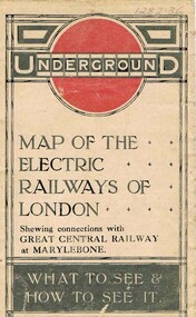
Document - ROBERT DENIS KELLY COLLECTION: MAP OF ELECTRIC RAILWAYS OF LONDON
... . Folds into 9 x 14 map. Details include tourist destinations... into 9 x 14 map. Details include tourist destinations ...Document: map of the electric railways of London. Buff coloured document, printed in black, white and red on front cover. Folds into 9 x 14 map. Details include tourist destinations, descriptions of costs etc.Johnson, Riddle & Co. Ltd. London.person, robert denis kelly, world war 1, france, london, underground, electric railway -
 Victorian Railway History Library
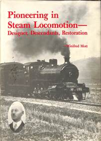
Book, Mott, Winifred, Pioneering in Steam Locomotion - Designer, Descendants, Restoration
A history of the locomotive designer Eugene Victor Siepen & the Mornington Railway Preservation Societyindex, ill, maps, p.239.non-fictionA history of the locomotive designer Eugene Victor Siepen & the Mornington Railway Preservation Societyrailroad engineers -- australia -- .biography, tourist railways and museums - victoria -
 Bendigo Historical Society Inc.
Map - Map of Lake Eppalock shoreline when empty
John Perry Collection. Laminated copy of map detailing Lake Eppalock shoreline when empty. Circa 1951. Has colored highlighter lines following roads leading to lake shoreline and various inundated old roads and tracks on lakebed. The dam was built by the State Rivers and Water Supply Commission of Victoria. The dam wall height is 45 metres (148 ft) and the main embankment is 1,041 metres (3,415 ft) long. At 100% capacity the dam wall was designed to hold back 304,651 megalitres (6.7014×10¹⁰ imp gal; 8.0480×10¹⁰ US gal) of water. The surface area of Lake Eppalock is 3,011 hectares (7,440 acres) and the catchment area is 2,124 square kilometres (820 sq mi). The controlled spillway is capable of discharging 8,040 cubic metres per second (284,000 cu ft/s). Lake Eppalock supplies both stock and domestic water to the Campaspe irrigation district. It also serves as a water supply to Bendigo and Heathcote and, in more recent times, Ballarat. The lake is a major attraction for those engaging in watersports, with a number of tourist parks and accommodation facilities available. Permissible activities on the lake include high-speed boating, water skiing, sailing, canoeing, fishing and swimming. The lake's water levels were low for approximately eight years between 2002 and 2010 during a prolonged drought, which restricted the amount of recreational activity until rainfall in the latter half of 2010 returned the lake to 100 percent capacity. Built between 1961 and 1964, Lake Eppalock remains the only water storage on the Campaspe River system.map, eppalock, reservoir, lake, water -
 Bendigo Historical Society Inc.
Map - Laminated map of Lake Eppalock at full capacity
John Perry Collection. Laminated copy of map of Lake Eppalock at full capacity. Had highlighter markings of old roads which appear to be still in use. The dam was built by the State Rivers and Water Supply Commission of Victoria. The dam wall height is 45 metres (148 ft) and the main embankment is 1,041 metres (3,415 ft) long. At 100% capacity the dam wall was designed to hold back 304,651 megalitres (6.7014×10¹⁰ imp gal; 8.0480×10¹⁰ US gal) of water. The surface area of Lake Eppalock is 3,011 hectares (7,440 acres) and the catchment area is 2,124 square kilometres (820 sq mi). The controlled spillway is capable of discharging 8,040 cubic metres per second (284,000 cu ft/s). Lake Eppalock supplies both stock and domestic water to the Campaspe irrigation district. It also serves as a water supply to Bendigo and Heathcote and, in more recent times, Ballarat. The lake is a major attraction for those engaging in watersports, with a number of tourist parks and accommodation facilities available. Permissible activities on the lake include high-speed boating, water skiing, sailing, canoeing, fishing and swimming. The lake's water levels were low for approximately eight years between 2002 and 2010 during a prolonged drought, which restricted the amount of recreational activity until rainfall in the latter half of 2010 returned the lake to 100 percent capacity. Built between 1961 and 1964, Lake Eppalock remains the only water storage on the Campaspe River system.map, water, dam, reservoir, eppalock -
 Bendigo Historical Society Inc.
Map - Laminated worksheet - identification of inundated artifacts at Lake Eppalock
John Perry Collection. Laminated copy of worksheet identifying inundated artifacts at Lake Eppalock when at 10% capacity. The dam was built by the State Rivers and Water Supply Commission of Victoria. The dam wall height is 45 metres (148 ft) and the main embankment is 1,041 metres (3,415 ft) long. At 100% capacity the dam wall was designed to hold back 304,651 megalitres (6.7014×10¹⁰ imp gal; 8.0480×10¹⁰ US gal) of water. The surface area of Lake Eppalock is 3,011 hectares (7,440 acres) and the catchment area is 2,124 square kilometres (820 sq mi). The controlled spillway is capable of discharging 8,040 cubic metres per second (284,000 cu ft/s). Lake Eppalock supplies both stock and domestic water to the Campaspe irrigation district. It also serves as a water supply to Bendigo and Heathcote and, in more recent times, Ballarat. The lake is a major attraction for those engaging in watersports, with a number of tourist parks and accommodation facilities available. Permissible activities on the lake include high-speed boating, water skiing, sailing, canoeing, fishing and swimming. The lake's water levels were low for approximately eight years between 2002 and 2010 during a prolonged drought, which restricted the amount of recreational activity until rainfall in the latter half of 2010 returned the lake to 100 percent capacity. Built between 1961 and 1964, Lake Eppalock remains the only water storage on the Campaspe River system.map, artifacts, eppalock, reservoir -
 Bendigo Historical Society Inc.
Map - Black and white map pertaining to Lake Eppalock
John Perry Collection. Laminated copy of map pertaining to Lake Eppalock. Gives details of dwellings, bridges and ford crossings. The dam was built by the State Rivers and Water Supply Commission of Victoria. The dam wall height is 45 metres (148 ft) and the main embankment is 1,041 metres (3,415 ft) long. At 100% capacity the dam wall was designed to hold back 304,651 megalitres (6.7014×10¹⁰ imp gal; 8.0480×10¹⁰ US gal) of water. The surface area of Lake Eppalock is 3,011 hectares (7,440 acres) and the catchment area is 2,124 square kilometres (820 sq mi). The controlled spillway is capable of discharging 8,040 cubic metres per second (284,000 cu ft/s). Lake Eppalock supplies both stock and domestic water to the Campaspe irrigation district. It also serves as a water supply to Bendigo and Heathcote and, in more recent times, Ballarat. The lake is a major attraction for those engaging in watersports, with a number of tourist parks and accommodation facilities available. Permissible activities on the lake include high-speed boating, water skiing, sailing, canoeing, fishing and swimming. The lake's water levels were low for approximately eight years between 2002 and 2010 during a prolonged drought, which restricted the amount of recreational activity until rainfall in the latter half of 2010 returned the lake to 100 percent capacity. Built between 1961 and 1964, Lake Eppalock remains the only water storage on the Campaspe River system.eppalock, map, water, dam, reservoir -
 Bendigo Historical Society Inc.
Map - Map of overlay of lake Eppalock at full capacity. Map 'C'
John Perry collection. Map 'C'. Laminated map of overlay of Lake Eppalock at full capacity. Circa 1951. The dam was built by the State Rivers and Water Supply Commission of Victoria. The dam wall height is 45 metres (148 ft) and the main embankment is 1,041 metres (3,415 ft) long. At 100% capacity the dam wall was designed to hold back 304,651 megalitres (6.7014×10¹⁰ imp gal; 8.0480×10¹⁰ US gal) of water. The surface area of Lake Eppalock is 3,011 hectares (7,440 acres) and the catchment area is 2,124 square kilometres (820 sq mi). The controlled spillway is capable of discharging 8,040 cubic metres per second (284,000 cu ft/s). Lake Eppalock supplies both stock and domestic water to the Campaspe irrigation district. It also serves as a water supply to Bendigo and Heathcote and, in more recent times, Ballarat. The lake is a major attraction for those engaging in watersports, with a number of tourist parks and accommodation facilities available. Permissible activities on the lake include high-speed boating, water skiing, sailing, canoeing, fishing and swimming. The lake's water levels were low for approximately eight years between 2002 and 2010 during a prolonged drought, which restricted the amount of recreational activity until rainfall in the latter half of 2010 returned the lake to 100 percent capacity. Built between 1961 and 1964, Lake Eppalock remains the only water storage on the Campaspe River system.map, water, eppalock, dam, reservoir -
 Bendigo Historical Society Inc.
Map - Laminated map of Lake Eppalock at full capacity. Map 'E'
John Perry Collection. Laminated map of Lake Eppalock at full capacity. Black and white. The dam was built by the State Rivers and Water Supply Commission of Victoria. The dam wall height is 45 metres (148 ft) and the main embankment is 1,041 metres (3,415 ft) long. At 100% capacity the dam wall was designed to hold back 304,651 megalitres (6.7014×10¹⁰ imp gal; 8.0480×10¹⁰ US gal) of water. The surface area of Lake Eppalock is 3,011 hectares (7,440 acres) and the catchment area is 2,124 square kilometres (820 sq mi). The controlled spillway is capable of discharging 8,040 cubic metres per second (284,000 cu ft/s). Lake Eppalock supplies both stock and domestic water to the Campaspe irrigation district. It also serves as a water supply to Bendigo and Heathcote and, in more recent times, Ballarat. The lake is a major attraction for those engaging in watersports, with a number of tourist parks and accommodation facilities available. Permissible activities on the lake include high-speed boating, water skiing, sailing, canoeing, fishing and swimming. The lake's water levels were low for approximately eight years between 2002 and 2010 during a prolonged drought, which restricted the amount of recreational activity until rainfall in the latter half of 2010 returned the lake to 100 percent capacity. Built between 1961 and 1964, Lake Eppalock remains the only water storage on the Campaspe River system.map, eppalock, water, dam, reservoir -
 Bendigo Historical Society Inc.
Map - Laminated map of Lake Eppalock empty. Map 'D'
John Perry Collection. Laminated map of Lake Eppalock empty. Map 'D'. Circa 1951. The dam was built by the State Rivers and Water Supply Commission of Victoria. The dam wall height is 45 metres (148 ft) and the main embankment is 1,041 metres (3,415 ft) long. At 100% capacity the dam wall was designed to hold back 304,651 megalitres (6.7014×10¹⁰ imp gal; 8.0480×10¹⁰ US gal) of water. The surface area of Lake Eppalock is 3,011 hectares (7,440 acres) and the catchment area is 2,124 square kilometres (820 sq mi). The controlled spillway is capable of discharging 8,040 cubic metres per second (284,000 cu ft/s). Lake Eppalock supplies both stock and domestic water to the Campaspe irrigation district. It also serves as a water supply to Bendigo and Heathcote and, in more recent times, Ballarat. The lake is a major attraction for those engaging in watersports, with a number of tourist parks and accommodation facilities available. Permissible activities on the lake include high-speed boating, water skiing, sailing, canoeing, fishing and swimming. The lake's water levels were low for approximately eight years between 2002 and 2010 during a prolonged drought, which restricted the amount of recreational activity until rainfall in the latter half of 2010 returned the lake to 100 percent capacity. Built between 1961 and 1964, Lake Eppalock remains the only water storage on the Campaspe River system.map, water, dam, reservoir, eppalock -
 Bendigo Historical Society Inc.
Document - Directions to Lake Eppalock with road descriptions and map
John Perry Collection. Laminated copy of 'Directions to Lake Eppalock'. Gives directions in relationship of Lake Eppalock to Bendigo, Kyneton and Heathcote. Undated. Gives basic descriptions of bridges on lakebed, ford crossings on lakebed and inundated dwellings on lakebed. The dam was built by the State Rivers and Water Supply Commission of Victoria. The dam wall height is 45 metres (148 ft) and the main embankment is 1,041 metres (3,415 ft) long. At 100% capacity the dam wall was designed to hold back 304,651 megalitres (6.7014×10¹⁰ imp gal; 8.0480×10¹⁰ US gal) of water. The surface area of Lake Eppalock is 3,011 hectares (7,440 acres) and the catchment area is 2,124 square kilometres (820 sq mi). The controlled spillway is capable of discharging 8,040 cubic metres per second (284,000 cu ft/s). Lake Eppalock supplies both stock and domestic water to the Campaspe irrigation district. It also serves as a water supply to Bendigo and Heathcote and, in more recent times, Ballarat. The lake is a major attraction for those engaging in watersports, with a number of tourist parks and accommodation facilities available. Permissible activities on the lake include high-speed boating, water skiing, sailing, canoeing, fishing and swimming. The lake's water levels were low for approximately eight years between 2002 and 2010 during a prolonged drought, which restricted the amount of recreational activity until rainfall in the latter half of 2010 returned the lake to 100 percent capacity. Built between 1961 and 1964, Lake Eppalock remains the only water storage on the Campaspe River system.water, dam, directions, eppalock -
 Bendigo Historical Society Inc.
Document - Legend to maps A, B and C for Lake Eppalock
John Perry Collection. Laminated 'legend' for Maps A, B and C for Lake Eppalock also in this collection. Black and White definitions and descriptions of objects and markers found on maps. Circa 1951. The dam was built by the State Rivers and Water Supply Commission of Victoria. The dam wall height is 45 metres (148 ft) and the main embankment is 1,041 metres (3,415 ft) long. At 100% capacity the dam wall was designed to hold back 304,651 megalitres (6.7014×10¹⁰ imp gal; 8.0480×10¹⁰ US gal) of water. The surface area of Lake Eppalock is 3,011 hectares (7,440 acres) and the catchment area is 2,124 square kilometres (820 sq mi). The controlled spillway is capable of discharging 8,040 cubic metres per second (284,000 cu ft/s). Lake Eppalock supplies both stock and domestic water to the Campaspe irrigation district. It also serves as a water supply to Bendigo and Heathcote and, in more recent times, Ballarat. The lake is a major attraction for those engaging in watersports, with a number of tourist parks and accommodation facilities available. Permissible activities on the lake include high-speed boating, water skiing, sailing, canoeing, fishing and swimming. The lake's water levels were low for approximately eight years between 2002 and 2010 during a prolonged drought, which restricted the amount of recreational activity until rainfall in the latter half of 2010 returned the lake to 100 percent capacity. Built between 1961 and 1964, Lake Eppalock remains the only water storage on the Campaspe River system.map, water, dam, reservoir, eppalock -
 Bendigo Historical Society Inc.
Map - Black and White map. Outline of Lake Eppalock. Map 'B'
John Perry Collection. Laminated copy black and white map. Map 'B'. Outline of Lake Eppalcok, overlayed on map. Circa 1951. The dam was built by the State Rivers and Water Supply Commission of Victoria. The dam wall height is 45 metres (148 ft) and the main embankment is 1,041 metres (3,415 ft) long. At 100% capacity the dam wall was designed to hold back 304,651 megalitres (6.7014×10¹⁰ imp gal; 8.0480×10¹⁰ US gal) of water. The surface area of Lake Eppalock is 3,011 hectares (7,440 acres) and the catchment area is 2,124 square kilometres (820 sq mi). The controlled spillway is capable of discharging 8,040 cubic metres per second (284,000 cu ft/s). Lake Eppalock supplies both stock and domestic water to the Campaspe irrigation district. It also serves as a water supply to Bendigo and Heathcote and, in more recent times, Ballarat. The lake is a major attraction for those engaging in watersports, with a number of tourist parks and accommodation facilities available. Permissible activities on the lake include high-speed boating, water skiing, sailing, canoeing, fishing and swimming. The lake's water levels were low for approximately eight years between 2002 and 2010 during a prolonged drought, which restricted the amount of recreational activity until rainfall in the latter half of 2010 returned the lake to 100 percent capacity. Built between 1961 and 1964, Lake Eppalock remains the only water storage on the Campaspe River system.map, water, dam, reservoir, eppalock