Showing 2474 items
matching township
-
 Linton and District Historical Society Inc
Certificate of Title, Certificate of Title: Allotment 36, Section 4, Township of Linton
Title of the land was transferred to James Adolphus Nelson and Theophilus William Nelson in 1955. James and Theo Nelson had already purchased adjacent allotments 27 - 30 in 1929.Copy of a Certificate of Title for an allotment of land situated between Grantley Street and Springdallah Creek in Linton. Copy comprised of three photostat sheets held together by tape. Most recent holders of the Title recorded as James Adolphus Nelson and Theophilus William Nelson.certificates of title, allotment 36 section 4 township of linton, james adolphus nelson, theophilus william nelson -
 Ringwood and District Historical Society
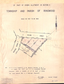
Document - Plan of Subdivision, Part of Crown Allotment 25 Section E, Township and Parish of Ringwood - 1961
Map showing residential allotments numbered 1, 2, 3 and 4, on Wilson Street and Braeside Avenue, Ringwood East, Victoria.Signed and dated 1/12/1961. Rubber stamped Kirkpatrick & Webber, Licensed Surveyors, Civil Engineers & Town Planners, 225 Maroondah Highway, Ringwood, Telephone 870-0321. Ref 3438C. "Note: Lot 4 is to be transferred to the Registered Proprietor of Lot 2 on Lodged Plan 23477 and is to be consolidated therewith." Map also includes handwritten Estate Agent notations. -
 Ringwood and District Historical Society
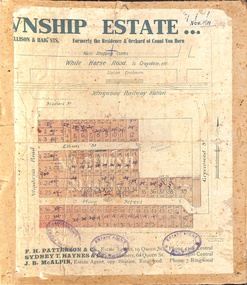
Map, Two Partially Trimmed Copies of Ringwood Township Estate subdivision advertisement - 1919
Clippings on cardboard backing. Handwritten sales notations on numbered allotments in Ellison Street, Haig Street and Wantirna Road, Ringwood.One copy includes three oval rubber stamp impressions - F. Parker, Estate Agent, Ringwood. -
 Ringwood and District Historical Society
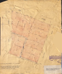
Document - Plan of Subdivision, Parts of Crown Allotments 45 & 46, Township & Parish of Ringwood, County of Mornington - 1950
Map on manila folder attached to cardboard backing showing residential allotments on King Street and Holland Road, Ringwood East.Signature of Russell Francis Kinnane, Licensed Surveyor, 4th December, 1950. -
 Kiewa Valley Historical Society
Photo - Bogong Township, September 1953
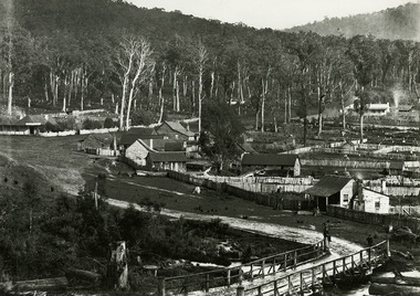
In 1940 Field Headquarters for the Kiewa Scheme were established at Bogong with office, workshop facilities and accommodation for workmen, staff and some families constructed. (There had been a 'tent camp' on this site in 1939 but was destroyed by bushfires) Construction of accommodation continued until 1947. A total of 40 houses plus a hostel for single staff, post office, police station, medical centre and primary school all with water and sewerage and electricity supply. The staff hostel was known as Kiewa House and is now occupied by the Education Department. Lake Guy was named after Mr. L.T. Guy who was the Resident Engineer in charge of construction work and associated activities on the Kiewa area. He held this position from 1939 to November 1946 when he was transferred to Head Office. The Bogong Township was developed firstly as an accommodation centre (base camp) for construction workers employed under the Kiewa Hydroelectric Scheme. Due to the influx of European workers into the Township the beautification of the immediate surrounds (gardens etc.) had a distinct European flavour. This environment has been very beneficial for tourism in later years. At the completion of the scheme, in the 1960's, the village was opened to public/tourism use. Strict environmental control has not allowed for any extensive redevelopment in tourist accommodation and basically restricted it to the accommodation initially built for the construction workers. Activities such a bike riding, snow skiing, restricted horse riding and bush walking on the Alpine plains and mountains are now a viable part of the Kiewa Valley Tourist Industry. The lake is one of the many water storage reservoirs used to supply the power stations their main power to run the huge turbines generating the final product, electricityBlack and white photograph of Bogong Township taken from Little Arthur fire track. September 1953Faded handwritten inscription on back - Bogong Township taken from Little Arthur fire track. Sept 1953bogong village, secv -
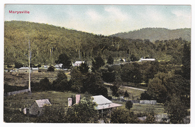
 Marysville & District Historical Society
Photograph (Item) - Black and white photograph, Nicholas John Caire, 1883
An early black and white photograph of the township of Marysville in Victoria.An early black and white photograph of the township of Marysville in Victoria. This photograph of Marysville was taken by Nicholas John Caire in 1883. Nicholas John Caire was born in 1837 in Guernsey. He arrived in Adelaide about 1860 along with his parents who encouraged his early interest in photography. He opened a studio in Adelaide in 1867 after traveling extensively throughout the Gippsland taking photographs. After marrying in 1870 he moved to Talbot in Victoria until 1876 when he opened a studio in the Royal Arcade in Melbourne. After 1885 Nicholas John Caire gave up his city work and made his home in South Yarra and devoted the rest of his life to outdoor photography, specializing in the bush, the gullies, and the mountains of south-eastern Victoria. nicholas john caire, marysville, victoria -
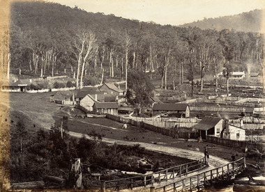
 Clunes Museum
Photograph
PART OF CLUNES TOWNSHIP FROM CAMP PARADE.TOWNSHIP VIEW OF CLUNES, FROM LOWER FRASER STREET, TWO BRIDGES IN PICTURE.CLUNES FROM CAMP PARADE. CIRCA 1897local history, photography, photographs, clunes township -
Whitehorse Historical Society Inc.
Document, An extract from notes made by a Mitcham resident in 1962 looking back to her schooldays, 1962
Document on school life in Mitcham in 1913 by Hilda Boxshall.Document on school life in Mitcham in 1913 by Hilda Boxshall. Document on Mitcham township 1914.Document on school life in Mitcham in 1913 by Hilda Boxshall. boxshall, hilda, mitcham, mitcham primary school, no. 2904 -
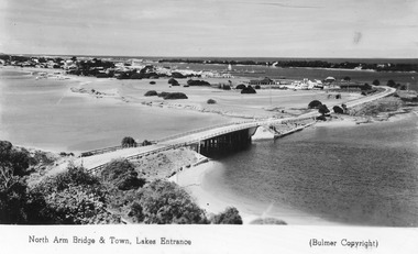 Lakes Entrance Historical Society
Postcard - Lakes Entrance from Jemmys Point, Bulmer H D, 1950c
Township of Lakes Entrance from Jemmys PointColour tinted postcard of township showing bridge across North Arm; town buildings including Club Hotel, Methodist Church, Maranui Guest House; tower of Central Hotel; jetties in Cunninghame Arm, and sand dunes. Caravan parked beside concrete brick constructed toilet block opposite road to Bullock Island. Footbridge across Cunninghame Arm in distance, also lookout tower on Esplanade, and Life Saving tower over hummocks. Lakes Entrance VictoriaNorth Arm Bridge and Town, Lakes Entrancetownship, jetties, guesthouses, islands, hotels -
 Marysville & District Historical Society
Postcard (item) - Colour postcard, Marysville, Victoria, Unknown
A colour postcard of the early Marysville township in Victoria.Early postcard of Marysville c.1900POST CARD Stamp Here Printed in Australia This space may be used for Correspondence/ within the Commonwealth without/ extra postage THIS SPACE FOR NAME AND/ ADDRESSmarysville, victoria, postcard, souvenir -
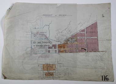 Bendigo Historical Society Inc.
Map - WALMER, Circa 1900
Map: Township of Walmer, 2 hand Draughted Parish plansmap, township, walmer -
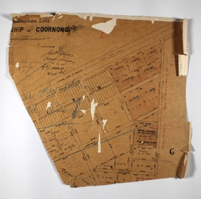 Bendigo Historical Society Inc.
Map - GOORNONG, Circa 1870's
Map: Suburban Lots in the Township of Goornongmap, bendigo, township, goornong, township of goornong -
Tatura Irrigation & Wartime Camps Museum
Photograph, Aerial of Tatura 1930, 1930
Early aerial photograph of township of Tatura. Main buildings and street can be seen. Copied by W. Purcell. Original held by donor A. Hampton.Black and white photograph taken from a small plane of township of Taturaon back: aerial photo of Tatura 1930. -
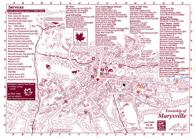 Marysville & District Historical Society
Map (Item) - Information map, Michael Hampton, 2000
An information map of the township of Marysville. This map was produced by McNamara Country Real Estate in 2000. The artist who drew the map was named Michael Hampton.An information map of the township of Marysville.MICHAEL HAMPTON/ 2000 VERSION 1:2/ 01/01marysville, victoria, australia, tourist map, information map, mcnamara country real estate, michael hampton -
 Lakes Entrance Historical Society
Postcard, H D Bulmer, Buchan Victoria, 1920 c
Black and white postcard showing a car parked on road above township of Buchan Victoria. Also an enlarged copy of same photographtownship -
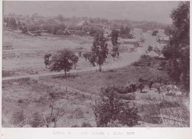
 Clunes Museum
Photograph
SEPIA PHOTOGRAPH - CLUNES TOWNSHIP AFTER SNOW STORM 1981.local history, photography, photographs, township -
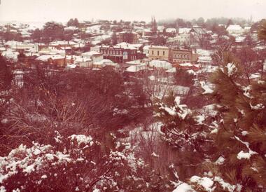
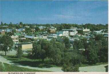 Rutherglen Historical Society
Post Card Folder, Nucolorvue Productions Pty Ltd, Big 7 Folder, Vue Pac. 7 Detachable Post Cards of Rutherglen Victoria, c1970
Donated by Mrs Brian Jasper.Coloured post cards in folder with views of Rutherglen and District. This one is a view of Rutherglen Township.On message side of card: "Rutherglen Victoria. Rutherglen township which was first established in the 1880's in the boom years of gold mining, is now the heart of a wine industry. | NCV.1047 Nucolorvue Productions Pty Ltd."rutherglen township -
 Marysville & District Historical Society
Postcard (item) - Colour tinted postcard, Victorian Stamp Market, Marysville, Victoria, Unknown
A colour-tinted photograph of the early Marysville township in Victoria. This postcard was published by Victorian Stamp Market as a souvenir of Marysville.Early postcard of Marysville township c.1900POST CARD Printed in Germany This Space may be used for Correspondence. FOR ADDRESS ONLY V.S.M. Series.marysville, victoria, victorian stamp market, postcard, souvenir -
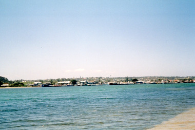 Lakes Entrance Historical Society
Photograph - Lakes Entrance, Davies, Judy, 2005c
Colour photograph of the township viewed across the Cunninghame Arm from the New Works area. Lakes Entrance Victoriawaterways, township -
 Bendigo Historical Society Inc.
Map - JACK FLYNN COLLECTION: TOWNSHIP OF STANHOPE, December 1950
Map: Township of Stanhope, Parish of Girgarre, County of Rodney. Parish plan.By Authority J. J. Gourley, Government Printer, Melbourne. Drawn and Reproduced at the Dept, of Lands and Survey, Melbourne, Victoria.map, rodney, township, stanhope -
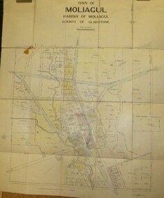 Bendigo Historical Society Inc.
Map - JACK FLYNN COLLECTION: MOLIAGUL, 7/02/1931
Map: Township of Moliagul, Parish of Moliagul, County of Gladstone. Parish plan.map, gladstone, township, moliagul -
 Bendigo Historical Society Inc.
Map - JACK FLYNN COLLECTION: GIRGARRE, 1957
Map: Township of Girgarre, Parish of Kyabram, County of Rodney. Parish plan.By Authority: W. M. Houston, Government Printer, Melbourne. Drawn and reproduced at the Department of Lands and Survey, Melbourne.map, rodney, township, girgarre -
 Bendigo Historical Society Inc.
Map - JACK FLYNN COLLECTION: GOORNONG, August 1953
Map: Township of Goornong, Parish of Goornong, County of Bendigo. Parish plan.By Authority W.M. Houston. Government Printer. Drawn and Reproduced at the Dept., of Lands and Survey, Melbourne, Victoria. August 1953map, bendigo, township, goornong -
Lakes Entrance Historical Society
Book, Bundalaguah Centenary Committee, Back to Bundalaguah, 1972
A souvenir booklet produced for the centenary of the Parish and township of Bundalaguah Gippsland Victoriatownship, settlers, agriculture, education -
Phillip Island and District Historical Society Inc.
Photograph, circa 1900
The first Punt under construction at Newhaven. Charlie Newman and wife with unknown man with bandaged arm. Across the water is view of San Remo township. Overhanging ??Close-up of Punt in San Remo waters. Background view of San Remo township.local history, photography, photographs, slides, film, the first punt, san remo punt, black & white photograph, miss elms san remo -
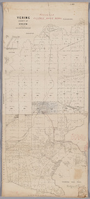 Yarra Ranges Regional Museum
Map, District of Yering, 1 Dec 1885
Canvas backed paper map of District of Yering, Country of Evelyn, showing proposed waterworks for township of Lilydale. Signed by Hodgson & Smith, water supply engineers. Proposed waterworks for the township of Lilydale. Signed by Hodgson & Smith, water supply engineers. Proposed water main shown with of reservoir etc. Canvas backed paper map of District of Yering, Country of Evelyn, showing proposed waterworks for township of Lilydale. Signed by Hodgson & Smith, water supply engineers. Proposed waterworks for the township of Lilydale. Signed by Hodgson & Smith, water supply engineers. Proposed water main shown with of reservoir etc. evelyn, lilydale, waterworks and irrigation -
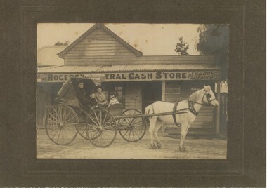 Rutherglen Historical Society
Photograph - Image, 1920s
Black and white photograph, mounted on cardboard, of a horse and cart with the family of the "Stewarts". Photo taken in the early 1920s outside Roger's General Cash Store, Great Northern Township"Early 1920s at Great Northern Township, via Rutherglen. L to R Fanny Stewart, Hector Stewart, Rae Stewart, Myra Stewart."stewart family, fanny stewart, hector stewart, rae stewart, myra stewart, rogers store, general cash store, great northern township -
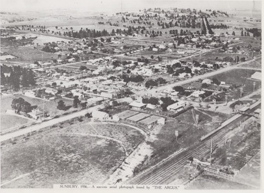 Sunbury Family History and Heritage Society Inc.
Photograph, 1936
The aerial view of Sunbury was featured in The Argus newspaper in 1936 in recognition of 100 years of European settlement of the area. It shows the extent of the township in 1936 which extended from the railway line in the west to the Jackson Creek in the east and the Sunbury Asylum in the south and northwards towards Macedon Street. The photograph was taken when Sunbury was a country settlement 25 miles ( 37 kms) from Melbourne. Since the 1980s the area grown rapidly and is now an outer suburb of Melbourne.A black and white aerial photograph with a cream border of the Sunbury township. SUNBURY 1936 - A SOUVENIR AERIAL PHOTOGRAPH ISSUED BY THE ARGUS.aerial photographs -
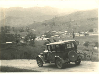
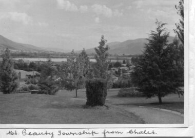 Kiewa Valley Historical Society
Photos - Mt Beauty and Surrounds, March 1960
Photos of the Kiewa Hydro Scheme and townships as they were in March 1960Pictorial record of the Hydro Electric Scheme in the 1960's when it was operated by the State Electricity Commission of Victoria (SECV). With the privatisation of the SECV in the 1990's the scheme passed to Southern Hydro and was then acquired by ALG Energy in 2005.4 black and white photographs of the Kiewa Valley area taken on a tour of the Kiewa Hydro Electric Scheme in March 1960 1. Mt Beauty township taken from the Mt Beauty Chalet 2. Mt Bogong, taken from Tawonga Gap 3. McKay portal pipeline 4. Bogong townshipmt beauty, kiewa hydro electric scheme, bogong, secv