Showing 2422 items
matching townships
-
 Bendigo Historical Society Inc.
Map - FOSTERVILLE MAP, 19/08/1897
Map: Township of Fosterville, Parish of Ellesmere, County of Bendigo. Parish plan (number 277 in map cupboard 1)map, bendigo, township, fosterville, ellesmere -
Bendigo Historical Society Inc.
Map - YARRABERB, 17/12/1937
Map: Township of Yarraberb, Parish of Yarraberb, County of Bendigo. Parish plan (number 274 in map cupboard 1)map, bendigo, township, yarraberb -
Bendigo Historical Society Inc.
Map - NEWBRIDGE, August 17th 1875
Map: Township of Newbridge, Parish of Tarnagulla, County of Bendigo. Parish plan (number 272 in map cupboard 1)map, bendigo, township, newbridge -
Bendigo Historical Society Inc.
Map - AXEDALE, 12/07/1909
Map: Township of Axedale, Parish of Axedale, County of Bendigo. Parish plan (number 271 in map cupboard 1)map, bendigo, township, axedale -
Clunes Museum
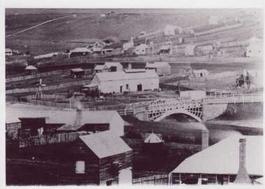
Photograph
Black and white framed photograph of the township of Clunes looking over bridge to Service Street and Fraser Street cornerservice street, fraser street, clunes streets -
Clunes Museum
Map, DEPT. OF LANDS AND SURVEY, TOWNSHIP OF CLUNES, PARISH OF CLUNES, COUNTY OF TALBOT, 1950
MAP OF CLUNES ON PAPER SHOWING HOTELS AND TOWNSHIP HIGHLIGHTS COMPLETE WITH LEGEND. OVERWRITTEN NOTATIONS IN RED AND BLUE INKPRICE 2stownship of clunes 1950, hotels of clunes -
Tatura Irrigation & Wartime Camps Museum
Photograph - aerial, Arthur J. Underwood, Kyabram, Tatura 1959, January 1959
J. Underwood was photographer for Kyabram Free PressBlack and white aerial photograph of Tatura township taken in 1959 by J. Underwood, Kyabram. Framed and under glass.j. underwood -
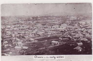 Clunes Museum
Photograph
PHOTOGRAPH OF CLUNES TOWNSHIP IN THE EARLY 1860'S -CONSISTING OF 1 POSTCARD AND 4 DIFFERENT SIZE PHOTO COPIESCLUNES IN THE EARLY SIXTIESlocal history, photography, photographs, clunes township -
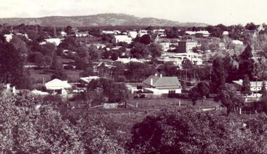 Clunes Museum
photograph
2 PHOTOGRAPHS (DIFFEREND SIZES) OF CLUNES TOWNSHIP TAKEN FROM THE SCENIC ROAD LOOKING TOWARDS MT-BECKWORTH.local history, photography, photographs, clunes township -
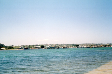 Lakes Entrance Regional Historical Society (operating as Lakes Entrance History Centre & Museum)
Photograph, Davies, Judy, 2005c
Colour photograph of the township viewed across the Cunninghame Arm from the New Works area. Lakes Entrance Victoriawaterways, township, public works -
Bendigo Historical Society Inc.
Map - TARNAGULLA : COUNTY OF BENDIGO, 1959
Map. Tarnagulla, County of Bendigo, County of Gladstone, Inglewood, Glenalbyn, Kingower, Moliagul, Painswick, Waanyarra, Laanecoorie, Woodstock, Derby, Loddon River, Dunolly to Inglewood Railway, Laurie Railway Station, Township of Tarnagulla, Tarnagulla Rifle Range, Township of Llanelly, Arnold Railway Station, Bullabul Creek, Kangderaar Creek, Township of Newbridge. By authority A.C. Brooks, Government Printer, Melbourne. Drawn and reproduced at the Department of Lands and Survey, Melbourne, 1959. (number 117 in map cupboard 1)A.C. Brooks, Government Printer, Melbourne.map, bendigo, tarnagulla -
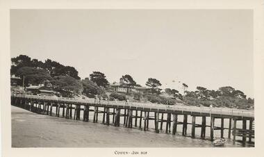 Phillip Island and District Historical Society Inc.
Photograph, 01/1938
One of 8 photographs donated by Joseph WhiteBlack & White photograph of the Cowes Pier, Phillip Island looking toward the Cowes township. Bayview Guesthouse in the centre background."Cowes, Jan 1938"cowes pier - phillip island, cowes jetty, joseph white -
 Phillip Island and District Historical Society Inc.
Photograph
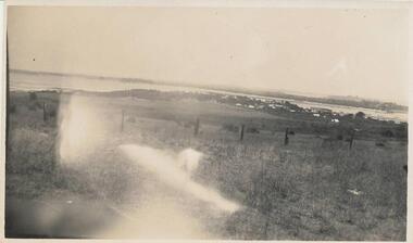
Part of a collection presented by Miss Edith Elms via Chrisy Northcote.Long paddocks foreground with fence posts and San Remo Township from Delomere, Panorama Drive. Phillip Island in background.local history, photography, photographs, san remo, sepia photograph, landscapes, westernport -
 Phillip Island and District Historical Society Inc.
Photograph
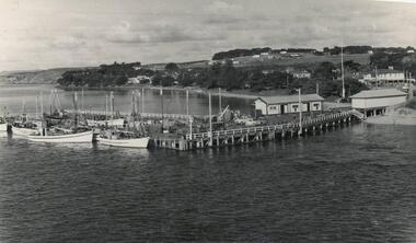
One of a collection of over 400 photographs in an album commenced in 1960 and presented to the Phillip Island & Westernport Historical Society by the Shire of Phillip IslandPhotograph showing portion of the fishing Fleet tied up at the San Remo Jetty with portion of San Remo Township in background.local history, photography, photographs, maritime technology, boats, the fishing fleet at san remo, shipping, fishing fleet, san remo jetty, john jenner, bryant west -
 Greensborough Historical Society
Photograph, Willis Vale 1906, taken from the hill, 1906_
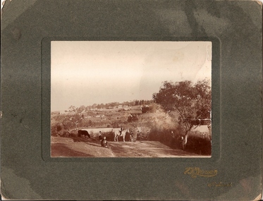
'Willis Vale' home of the Partington family is shown in this photograph as well as the area now known as Partington's Flat. The area was owned and farmed by the Partington family from the 1870s. The derelict Willis Vale house was destroyed in 1964 when a fire originating from North Plenty Gorge - Kurrak Road - lit by two teenage boys - made its way several kilometres down to Partington's Flat Greensborough.Photograph shows an early view of Greensborough in 1906.Professional photograph in sepia mounted on dark green card. Shows Greensborough township in background with Willis Vale homestead in centre. On back: A.M.Partington Greensborough 1906.willis vale, partington family, greensborough, alan partington -
Glenelg Shire Council Cultural Collection
Negative - Negative - Glenelg River, Victoria, c. 1934
Part of a collection of photographs taken by Zillah Maschmedt in 1934. Zillah was a teacher from South Australia.Transparency for black and white photo. View along Glenelg river at Nelson, Victoria. Township on right, bridge centre of the photo.zillah maschmedt, photography, glenelg river -
4th/19th Prince of Wales's Light Horse Regiment Unit History Room
Photograph, Nazareth, abt 1917
A black & white photograph showing the township of Nazareth. An open top motor vehicle bearing the the German eagle on the side is in the foregroundWritten on bottom of photo: NAZARETHphoto, nazareth -
Bendigo Historical Society Inc.
Map - TOWNSHIP OF KANGAROO FLAT, 27/01/1932
Map: Township of Kangaroo flat, Parish of Sandhurst , County of Bendigo. Parish plan ( number 194 in Map Cupboard 1)map, bendigo, township, kangaroo flat -
Bendigo Historical Society Inc.
Map - TOWNSHIP OF HEATHCOTE (PART), 11/04/1935
Map: Township of Heathcote (part), Parish of Heathcote, County of Dalhousie. Parish plan (number 259 in map cupboard 1)map, dalhousie, township, heathcote, copunty of dalhousie -
 Buninyong & District Historical Society
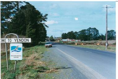
Photograph - Original Photograph, Mr. C.J. Brooks, Main street of Yendon from the West, September 1995
Social, historicalExample of the Moorabool Shire sign and the felling of trees for power company in the late twentieth centuryColour photo, of the Western outskirts of the township of Yendon showing 8-10 felled pine trees of the southern side of avenueroad signs, yendon, moorabool shire, streetscape, felled pinetrees, powercor -
Tatura Irrigation & Wartime Camps Museum
Aerial Photograph, 1959
Enlarged aerial photo of Tatura township taken by J. Underwood (Kyabram) in January 1959. Photo framed with glass front.Tatura Jan 1959. Arthur J. Underwood Photographer Tel. Kyabram 629tatura, aerial photography, photography, photograph, slides, film -
Clunes Museum
Photograph - DISPLAY PANEL
COPIES OF DISPLAY PANELS DONATED TO THE PEOPLE OF CLUNES BY THE HUGH WILLIAMSON FOUNDATION..1 INTERPRETIVE DISPLAY PANEL DEPICTING THE DISCOVERY OF GOLD AND THE DEVELOPMENT OF THE TOWNSHIP OF CLUNES. WOODEN FRAME .2 LAMINATED COPY local history, momentoes, presentations, williamson, hugh foundation -
 Clunes Museum
Photograph
BLACK & WHITE PHOTOGRAPH GENERAL VIEW CLUNES TOWNSHIP WITH GOVERNMENT BRIDGE IN CENTRE OF PHOTOGRAPH, EBERHARD SOFT DRINK FACTORYphotographs, township, goverment bridge -
Stawell Historical Society Inc
Book, Stawell Mining Co
Town Western Reefs Tyne Co. Township Reefs. Newspaper Reports from the Pleasant Creek News 1868 -1909gold mining -
 South Gippsland Shire Council
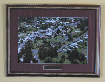
Photograph, Framed, Aerial Scene of Mirboo North, 2004
One of a set of two. Framed colour photograph titled: "Mirboo North Township 2004". Features an aerial photograph of the township of Mirboo North. Set in maroon card window mount and decorative brown and gold wood frame. Engraved brass text panel with white lined border affixed below image. -
 South Gippsland Shire Council
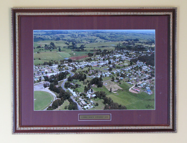
Photograph, Framed, Aerial town view of Mirboo North, 2004
One of a set of two. Framed colour photograph titled: "Mirboo North Township 2004". Features an aerial photograph of the township of Mirboo North. Set in maroon card window mount and decorative brown and gold wood frame. Engraved brass text panel with white lined border affixed below image. -
 Lakes Entrance Regional Historical Society (operating as Lakes Entrance History Centre & Museum)
Photograph, 1900c
Black and white photograph of the township, showing the township along Esplanade, Cunninghame Arm taken from the signal station at New Works. A very clear view of rear of Boole Poole School, later used as office, Pilot's residence and Harbour Engineer's residence, Carpenter's residence, and wooden boardwalk. Lakes Entrance Victoriawaterways, topography -
Glenelg Shire Council Cultural Collection
Negative - Negative -Glenelg River Nelson, Victoria, Miss Zillah Maschmedt, photographer, c. 1936
Negative for a black and white photograph. Image shows view across Glenelg River to Nelson township, bridge in foreground Nelson Victoria. -
Bendigo Historical Society Inc.
Map - TOWNSHIP OF HEAHCOTE SHEET 1, 29/07/1935
Map: Township of Heathcote sheet 1, parish of Heathcote, County of Dalhousie. Parish plan (number 253 in map cupboard 1)map, dalhousie, township, heathcote, conty of dalhousie