Showing 443 items matching "trestle"
-
 Bendigo Historical Society Inc.
Postcard - ACC LOCK COLLECTION: B&W PHOTO OF A FIELD BAKERY,POSTCARD, 1914-1918
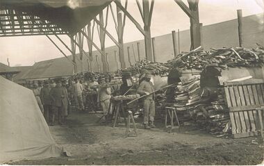
Postcard, WW1, B&W photo of a field bakery. Piles of timber next to a row of ovens. Several bakers standing next to ovens, one carrying a tray of bread. Other loaves sitting on trestles. Three army officers standing to the left. All men facing the camera. Location not known. Handwritten in pencil on the back - Feldbackerei (twice) and GSpostcard, ww1, france, bakery -
 Tatura Irrigation & Wartime Camps Museum
Photograph, 31/3/1916
Taken by photographer for State Rivers and Water Supply Commission.Medium sized black and white photograph. Sugarloaf Reservoir pay day / R. Burns, Senior Constable Waters, P. Descrimes, G Robinson and other men grouped around the short-sleeved paymaster / Pay books on trestle table on construction site / Timber chute running down hill beyond men / All men wearing hats.victorian state rivers and supply commission, sugarloaf reservoir -
 Eltham District Historical Society Inc
Photograph, Peter Bassett-Smith, Beautiful Eltham, Joh Ebeli, 1988
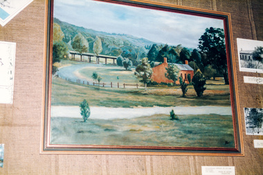
Former Shire of Eltham Art Collection now Nillumbik Shire Council Art Collection, 'Beautiful Eltham' by Joh Ebeli showing Shillinglaw Cottage and Railway Trestle Bridge. Bicentennial/Heritage Week Display, "The Eltham Tradition", Eltham Shire Office, 17-22 April 1988 Colour photographactivities, eltham shire office, heritage display, heritage week, beautiful eltham, joh ebeli, shillinglaw cottage, trestle bridge -
 Eltham District Historical Society Inc
Newsletter, Newsletter, No. 124 January 1999
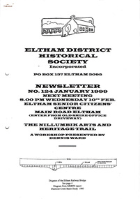
Contents: • Next meeting, The Nillumbik Arts and Heritage Trail; A workshop presented by Dennis Ward • February Meeting • Society Program 1999 • The Other Elthams • Annual General Meeting • Andrew Ross Museum • The Eltham Railway Bridge • Some Other Snippets • 1976 ‘Save the Trestle Bridge’ Poster The Shire of Eltham Historical Society was formed in October 1967. The first newsletter of the Society was issued May 1978 and has been published continuously ever since on a bi-monthly basis. With the cessation of the Shire of Eltham in late 1994, the Society's name was revised to Eltham District Historical Society and this name first appeared with issue No. 103, July 1995. The collection of the Society's newsletters provides a valuable resource on the history of the Society's activities, office bearers and committee members, guest speakers and subjects of historical interest pertinent to the former Shire of Eltham and the Eltham District.A4 photocopied newsletter distributed to membersnewsletter, eltham district historical society, shire of eltham historical society -
 Eltham District Historical Society Inc
Photograph, Railway Bridge construction between Eltham and Hurstbridge, c.1912
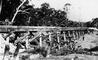
The railway was extended from Eltham to Hurstbridge in 1912. This bridge is most likely near Allendale Road, Diamond Creek. It was one of four original trestle bridges in the stretch north of Allendale Road, which were all burnt out in January 1969 (replaced by two steel bridges and two corrugated iron culverts).This photo forms part of a collection of photographs gathered by the Shire of Eltham for their centenary project book,"Pioneers and Painters: 100 years of the Shire of Eltham" by Alan Marshall (1971). The collection of over 500 images is held in partnership between Eltham District Historical Society and Yarra Plenty Regional Library (Eltham Library) and is now formally known as the 'The Shire of Eltham Pioneers Photograph Collection.' It is significant in being the first community sourced collection representing the places and people of the Shire's first one hundred years.Digital image One 4 x 5 inch B&W negative One 9 x 12.5 cm printshire of eltham pioneers photograph collection, hurstbridge, allendale road, hurstbridge railway extension, railway bridge, railway line construction, trestle bridge, diamond creek (creek) -
 Sunshine and District Historical Society Incorporated
Photographs (1928), 'QUARTER MILE' BRIDGE Construction, 1928
One man lost his life during the building of this bridge. The bridge was constructed by the Victorian Railways between 1927 to 1929 to carry a new double track goods line. This enabled trains from all parts of the state except Gippsland to have direct access to the Tottenham marshalling and sorting yards. These yards were constructed in the 1920's to relieve congestion in the Melbourne Yard near Spencer Street station. The congestion was being caused by the construction of suburban passenger platforms associated with the electrification of the suburban railway network. Initially the bridge was for goods trains but during the Second World War it was also used by troop trains. When the standard gauge line was built in 1962 all trains to Albury and Sydney have used this route, thus avoiding travelling through Essendon and Pascoe Vale on the suburban tracks. The standard gauge track across the bridge took the place of one of the broad gauge tracks so broad gauge trains crossing the bridge in either direction have to now use the same track. The bridge is 1,257 feet (383.13 metres) long and 180 feet (54.86 metres) above the water level. It is just 63 feet (19.2 metres) short of a quarter mile in length between abutments. There is a similar bridge on the same railway line crossing the Moonee Ponds Creek between Gowenbrae and Glenroy, however it is smaller at 1060 feet (323.08 metres) length and 115 feet (35.05) height.The bridge is now Victorian Heritage Registered under Number: H1197, and Heritage Overlay Numbers HO5, and HO107. On the Heritage Register it is named RAIL BRIDGE (ALBION VIADUCT). According to the Heritage Report the bridge is scientifically and architecturally important because of its large size, and because of the cost effective design features such as two girders per span (one for each track), the K bracing in the towers, and the broad flange beams as columns. When it was being built it was the largest trestle bridge in Australia, and until the Sydney Harbour bridge was constructed it was the highest railway bridge.Five B&W yellowing photos showing stages of construction of the Maribyrnong River Viaduct known as the Trestle Bridge but mainly known locally as the QUARTER MILE BRIDGE. It is a railway only bridge which runs over the Maribyrnong River between Sunshine North and Keilor East. A sixth image, which is not part of this set of photos, is included to show what the completed bridge looks like. -
 Lakes Entrance Historical Society
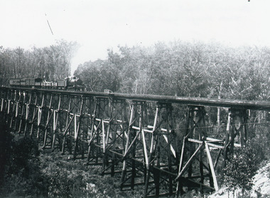
Photograph - Bridges, 1930
Also similar black and white copy 15 x 22 cmBlack and white photograph showing the trestle bridge over Stoney Creek near Nowa Nowa, shows Bairnsdale to Orbost train on left end of bridge. Train has four open goods trucks, two covered goods trucks, one louvred van and one passenger carriage, and guards van at rear. Tall forest in background, low scrub in front. Nowa Nowa Victoria.bridges, transport -
 Eltham District Historical Society Inc
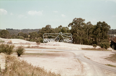
Slide, Construction of Eltham Town Park, 22 Feb 1974
Construction of Eltham Town Park, later renamed Alistair Knox Park. View looking across the front of Shillinglaw Cottage and what was to be developed as the Eltham Town Common (now the site of the Eltham Library) across to the Eltham Town Park development. To the right is the Eltham Trestle Bridge and to the left what was once the overflow site for the Susan Street Tip.35 mm colour positive transparency Mount - Agfacolor Service (Blue)alistair knox park, eltham town park, eltham tip, eltham town common, eltham trestle bridge -
 Eltham District Historical Society Inc
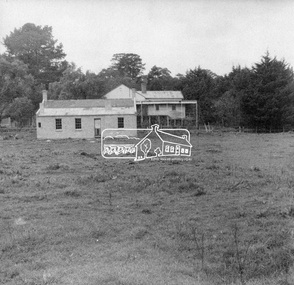
Negative - Photograph, George W. Bell, Re-erection of Shillinglaw Cottage, c.1966
View looking up from near the Eltham Railway Trestle Bridge over what was to become the Eltham Common at Shillinglaw Cottage in its new location prior to restoration. The former Gahan house, seen in the background was demolished in 1968 when the Main Road was duplicated in this section. The Eltham Common was taken over with the construction of the new Eltham Library which opened in 1994.Shillinglaw Cottage is itself historically, aesthetically and socially significant to the Shire of Nillumbik and is registered on the Victorian Heritage Database. This photo forms part of a collection of photographs gathered by the Shire of Eltham for their centenary project book, "Pioneers and Painters: 100 years of the Shire of Eltham" by Alan Marshall (1971). The collection of over 500 images is held in partnership between Eltham District Historical Society and Yarra Plenty Regional Library (Eltham Library) and is now formally known as 'The Shire of Eltham Pioneers Photograph Collection.' It is significant in being the first community sourced collection representing the places and people of the Shire's first one hundred years.Digital image 4 x 5 inch B&W Negsepp, shire of eltham pioneers photograph collection, eltham, shillinglaw cottage, eltham shire office, gahan house, derril, gahan, george w. bell collection, houses, main road -
 Eltham District Historical Society Inc
Newsletter, Newsletter, No. 4, November 1978
Contents: • Next meeting • Other coming events o Eltham Living Forum o Historical Exhibition o Smiths Gully Excursion o Committee meeting o Next year • Early Eltham house, Ely Street • Kinglake National Park • Kangaroo Ground School • Pioneers and Painters • Railway Trestle Bridge, Eltham • Local History Series • Yemmerrawannie The Shire of Eltham Historical Society was formed in October 1967. The first newsletter of the Society was issued May 1978 and has been published continuously ever since on a bi-monthly basis. With the cessation of the Shire of Eltham in late 1994, the Society's name was revised to Eltham District Historical Society and this name first appeared with issue No. 103, July 1995. The collection of the Society's newsletters provides a valuable resource on the history of the Society's activities, office bearers and committee members, guest speakers and subjects of historical interest pertinent to the former Shire of Eltham and the Eltham District.A4 photocopied newsletter distributed to membersnewsletter, eltham district historical society, shire of eltham historical society -
 Bendigo Historical Society Inc.
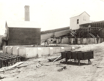
Photograph - DEEBLE'S PYRITIES WORKS, approx. 1950's
black and white photo - enlargement of industrial treatment works showing elevated building in background with two male adults. One by concrete vats at ground level, one on elevated landing. Container on trestles and timber in foreground. Weatherboard building by large concrete vat and acid ? Carboys at centre and left. Decorated brick chimneys ciovered race to upper building. On back in ink ? Foggit Jones? In grey lead Foggit Jones.organization, business, pyrites treatment plant -
 Eltham District Historical Society Inc
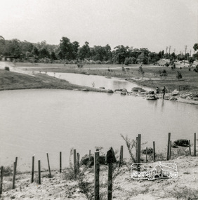
Photograph, Looking north across Eltham Town Park, 1974, 1974
Visible are Trestle Bridge, Eltham Shire Offices with south wing extension, duplicated Main Road, Panther Place and the pathway through the park. Shillinglaw Cottage in Eltham Common on the other side of Panther Place is hidden from view by the tree-capped grassy knoll. The two ponds were in construction during the Arbor Day native tree planting by local school children in October 1973.Black and white photographeltham town park, eltham shire office, main road, shillinglaw trees, trestle bridge -
 Bendigo Military Museum
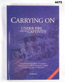
Book - BOOK, 8TH DIVISION AAMC, Carl Johnson, "CARRYING ON UNDER FIRE AND IN CAPTIVITY", 2009
Stories from the 8th Division Australian Army Medical Corps under Malaya Command, WWII. The 39th Australian Infantry Battalion (1941-1943) Association donated four books of Military History: Cat. No. 4474 With the Twenty-Second Cat. No. 4475 Carrying On Under Fire and in Captivity Cat. No. 4476 Mod Revisited Cat. No. 4477 Forward With The FifthHard cover - cardboard with dark blue glossy coloured background. White print on front, spine and back. Front illustrated black and blue toned photograph of 6 Medical Corp Soldiers in uniform. Back, photograph of trestle bridge on Thai-Burma Railway. Front and back figleaf and end papers illustrated with grey/blue and white maps. 559 pages, cut, plain, white. Illustrated black and white photographs, portraits, maps, drawings.Opposite Title Page - printed donation label - "Donated by 39th Australian Infantry Battalion (1941 - 1943) Association Inc, www.39battalion.com” Association Inc. www.39battalion.com"books, military, history, wwii -
 Southern Sherbrooke Historical Society Inc.
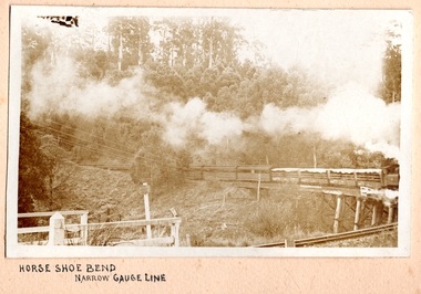
Photograph, Horse Shoe Bend on Narrow Gauge Line
Photo of Puffing Billy coming around the horseshoe bend at Selby and beginning to cross the trestle bridge, heading away from Belgrave. The engine is only part shown. It is hauling four open-sided carriages with canvas covers, and a further six or so enclosed carriages. There appears to be no wind as the smoke is hanging above the train. Railway infrastructure (barrier fences) can be seen in the foreground, and there are wires across the left side of the photo. c. 1920 -
 Bendigo Historical Society Inc.
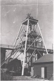
Photograph - NORTH DEBORAH GOLD MINE
Black and white photograph, copy, of the North Deborah Gold Mine poppet head, possibly taken in the 1940's. The trestle way and sky shaft used to convey ore to the landing brace are visible. Poppet head legs are metal and painted white. Corrugated iron sheds on right and in background. Air raid sirens on the top of the poppet head were used during World War 2 to warn the good citizens of Bendigo of any impending attack.bendigo, mining, north deborah gold mine -
 Southern Sherbrooke Historical Society Inc.
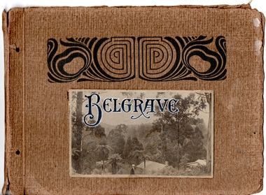
Album - Handmade photographic album, Belgrave
This album is made of strong cardboard now held together by ribbon and it contains 17 images taken around Belgrave in the early 1920s. The photographer is unknown but it could have been Charles Ladd, engraver, farmer, and amateur photographer, who lived with his family in Dewhurst. The photos are of local beauty spots in the Sherbrooke Forest, Lipscombe's Hill, Biffin's Hill and Selby trestle bridge areas. Several people appear in various photos and appear to be a group of family and/or friends. -
 Ballarat Tramway Museum
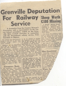
Newspaper, The Courier Ballarat, "Grenville Deputation for Railway Service", 6/03/1953 12:00:00 AM
Newspaper clipping from The Courier, 6/3/1953, titled "Grenville Deputation for Railway Service" reporting on the a deputation from the Country Women's Association, deputation to the Shire of Grenville supporting the restoration of the rail services on the Skipton line following the destruction by fire of the Newtown Trestle Bridge. Notes Council meeting with the VR Commissioners and departmental heads. Contained originally within Reg Item 5623 at the front of this note book. For items see btm5623 loose items list.pdf.skipton, railways, cwa -
Ballarat Tramway Museum
Document - Report, Transport Superannuation Board, "Transport Superannuation Board Annual Report 1993", 1993
16 page report on white paper with medium weight card covers, dark blue on outside, light blue on inside for the "Transport Superannuation Board Annual Report 1993". On front cover has photos of B2112, Port of Melbourne, Comeng train on the Eltham Trestle bridge and South Eastern Freeway. Report covers the various details of the funds, Board members, organisations that are part of the fund, member services, year in review, investments, actuarial report and financial report and Auditors Report.trams, tramways, superannuation, employees, annual reports -
 Eltham District Historical Society Inc
Photograph, Fay Bridge, Flood damage at Nillumbik Medical Centre, 1078 Main Road, Eltham, 26 December 2011
Flood damage resulting from a late afternoon storm on Christmas Day 2011. A flash flood occurred from significant rain fall and hail, which accumulated along an old waterway with floodwater submerging cars along Valonia Drive then down Grove Street flooding houses, through the Bible Street Reserve where it then submerged Main Road washing away the small railway trestle bridge opposite the reserve then flooding the Judge Book Village before finally entering the Diamond Creek..fay bridge collection, 2011-12-26, bible street reserve, flood damage, floods, floodwater, main road, nillumbik medical centre -
 Melton City Libraries
Photograph, Melton Railway Bridge, c.1884
"The Melton Viaduct, opened in 1886, is of State heritage significance as a very large and visually distinctive wrought iron, lattice girder trestle bridge over the Werribee River (now Melton Reservoir). It comprises 18.3 and 9.1 metre spans, in a generally alternate arrangement, of total length 375 metres, and standing 38 metres over the Werribee River. Wrought iron small section iron was used to build tension trussed trestle legs, which supported four lines of rivetted wrought-iron deck-type double lattice trusses. It has bluestone abutments and pier bases of coursed rock-faced bluestone with drafted margins. The larger half-piers, now usually submerged in the Melton Reservoir have sharp tapered cutwaters and curved coping at the tops. While designed to carry two rail tracks it has only ever been used as a single track line. Despite several alterations to its deck structure, it remains an outstanding example of a lighter structural design employing open metal trestle supports and metal truss girders. The direct Melbourne to Ballarat railway link of which the Melton viaduct was the major engineering work contributed significantly to the history and development of Victoria. This new link reflected Ballarat’s diversifying economy as well as the commercial and political influence of the metropolis. Construction of the bridge, and the associated large workers camp, were extensively photographed, documenting an important episode in local history. The railway enabled the development of new industries in the Melton area, notably the timber industry and a chaff industry of national importance, greatly facilitated the later transition of the Shire from a pastoral to a farming economy, and struck a major blow to Melton township’s era as a wayside town servicing Ballarat road (especially coach) traffic". Melton Railway Bridge being built across the Werribee Rivertransport -
 Kew Historical Society Inc
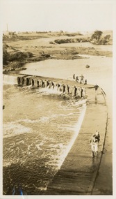
Photograph - Victorian Canoe Club, Dight's Falls, Studley Park, 1920-30
Canoeing on the River Yarra at Melbourne was an important and widespread recreational pursuit for Melbournians, especially in the first half of the twentieth century. The Victorian Canoe Club was formed in 1912 at a meeting in Melbourne and its first committee elected in the same year. Records indicate that the Club continued into at least the 1950s .The album has historic and social significance as a record of recreational activities (as well as canoe making) in the early years of the twentieth century. It has local significance as the site of the headquarters of the Club was in Studley Park. A number of photographs in the album provide vistas of Kew on the Yarra that are otherwise unavailable.One of 24 labelled photos in part album, originating from the Victorian Canoe Club, which had its headquarters in Studley Park, Kew. The album includes a photographic record of canoe construction and also locations in Studley Park and Kew where the canoes were used. The subject of this photograph is identified as 'Dight's Falls, Studley Park'.The view shows an early trestle bridge across the Falls on which people, possibly members of the Club, are standing. The point of view would appear to be looking up river towards Fairfield."Dyghts Falls, Studley Park"victorian canoe club, river yarra, burke road -- kew (vic.), dight's falls -- fairfield (vic.), dight's falls -- kew (vic.), dight's falls -- yarra river -
 Eltham District Historical Society Inc
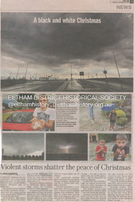
Newsclipping, Vince Chadwick, Violent storms shatter the peace of Christmas, The Age, Monday, December 26, p3, 2011
A late afternoon storm on Christmas Day 2011. A flash flood occurred from significant rain fall and hail, which accumulated along an old waterway with floodwater submerging cars along Valonia Drive then down Grove Street flooding houses, through the Bible Street Reserve where it then submerged Main Road washing away the small railway trestle bridge opposite the reserve then flooding the Judge Book Village before finally entering the Diamond Creek. Widespread damage occured from hail and flash flooding.fay bridge collection, 2011-12-26, eltham, flood damage, floods, grove street, main road, valonia drive -
 Eltham District Historical Society Inc
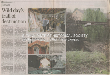
Newsclipping, Reid Sexton, Wild day's trail of destruction, The Age, Tuesday, December 27, pp4-5, 2011
A late afternoon storm on Christmas Day 2011. A flash flood occurred from significant rain fall and hail, which accumulated along an old waterway with floodwater submerging cars along Valonia Drive then down Grove Street flooding houses, through the Bible Street Reserve where it then submerged Main Road washing away the small railway trestle bridge opposite the reserve then flooding the Judge Book Village before finally entering the Diamond Creek. Widespread damage occured from hail and flash flooding.fay bridge collection, eltham, 2011-12-27, flood damage, floods, floodwater -
 Eltham District Historical Society Inc
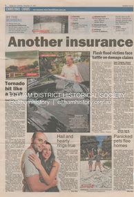
Newsclipping, Angus Thompson et al, Another insurance storm brews, Herald Sun, Tuesday, December 27, pp4-5, 2011
A late afternoon storm on Christmas Day 2011. A flash flood occurred from significant rain fall and hail, which accumulated along an old waterway with floodwater submerging cars along Valonia Drive then down Grove Street flooding houses, through the Bible Street Reserve where it then submerged Main Road washing away the small railway trestle bridge opposite the reserve then flooding the Judge Book Village before finally entering the Diamond Creek. Widespread damage occured from hail and flash flooding.fay bridge collection, eltham, 2011-12-27, flood damage, floods, floodwater -
 Eltham District Historical Society Inc
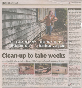
Newsclipping, Shaun Campbell, Clean-up to take weeks, Diamond Valley Leader, December 2011
A late afternoon storm on Christmas Day 2011. A flash flood occurred from significant rain fall and hail, which accumulated along an old waterway with floodwater submerging cars along Valonia Drive then down Grove Street flooding houses, through the Bible Street Reserve where it then submerged Main Road washing away the small railway trestle bridge opposite the reserve then flooding the Judge Book Village before finally entering the Diamond Creek. Widespread damage occured from hail and flash flooding.fay bridge collection, eltham, flood damage, floods, floodwater -
 Eltham District Historical Society Inc
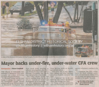
Newsclipping, Shaun Campbell, Mayor backs under-fire, under-water CFA crew, Diamond Valley Leader, December 2011
A late afternoon storm on Christmas Day 2011. A flash flood occurred from significant rain fall and hail, which accumulated along an old waterway with floodwater submerging cars along Valonia Drive then down Grove Street flooding houses, through the Bible Street Reserve where it then submerged Main Road washing away the small railway trestle bridge opposite the reserve then flooding the Judge Book Village before finally entering the Diamond Creek. Widespread damage occured from hail and flash flooding.fay bridge collection, eltham, flood damage, floods, floodwater, main road, research fire brigade -
 Eltham District Historical Society Inc
Slide, Shillinglaw Cottage, c.1973
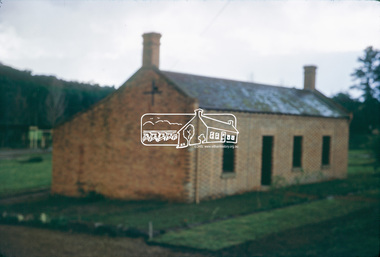
Shillinglaw Cottage was relocated in 1963 from its former site a few hundred metres up Main Road to make may for new shire offices built in 1964. It was situated near the Eltham Railway Trestle Bridge on a site that was developed into the Eltham Common. The new Eltham Town Park was constucted opposite on the other side of what was to become Panther Place. In 1993/94 the new Eltham Library was constructed on the Eltham Common. This picture, though out of focus still gives a reasonable impression of the cottage at the time.35 mm colour positive transparency Mount - Kodak Kodachrome Cardeltham common, shillinglaw cottage -
 Eltham District Historical Society Inc
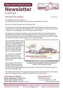
Newsletter, Eltham District Historical Society, Newsletter, No. 239 April 2018
Contents: • Every place has a history by Jim Connor • Annual General Meeting - 11th April 2018 • May Excursion - Edendale Environs • Eltham 1950s – Childhood Reminiscences – Part 3 by Ann Constable • Eltham Trestle Bridge by Richard Pinn • My Early Eltham Recollections – Part 2 by Alex Smith • Connect with us • Eltham Community Centre Opening by Russell Yeoman (Newsletter No.1, May 1978) • Annual General Meeting Notice • Hamish Knox and Associates • Contacts for the Eltham District Historical Society The Shire of Eltham Historical Society was formed in October 1967. The first newsletter of the Society was issued May 1978 and has been published continuously ever since on a bi-monthly basis. With the cessation of the Shire of Eltham in late 1994, the Society's name was revised to Eltham District Historical Society and this name first appeared with issue No. 103, July 1995. The collection of the Society's newsletters provides a valuable resource on the history of the Society's activities, office bearers and committee members, guest speakers and subjects of historical interest pertinent to the former Shire of Eltham and the Eltham District.A4 newsletter distributed to membersnewsletter, eltham district historical society -
 Ballarat Tramway Museum
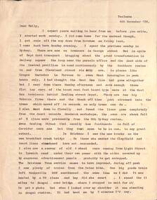
Letter - from Alwyn Marshall Toolamba to Wal Jack, Alwyn Marshall, 1958 & 1959
Wal Jack had an extensive range of correspondents throughout Australia and the world. This set are two letters from Alwyn Marshall of Toolamba, who travelled extensively. His first letter discusses tramways in Sydney, the type of trams in use, Brisbane tramways, NSW Railways on the Sydney to Brisbane line, Queensland railways, the Sandy Hollow line and the wooden trestle bridge near Nayook. He used a motor bike for his Australian travels. The second letter discusses the Frankford lines in Philadelphia and sending maps of the system.Demonstrates some of the correspondence that Wal Jack received from around the world.Set of two typed letters on quarto paper from Alwyn Marshall to Wal Jack 4 Dec 1958 - two sheets Friday, May 1 (no year), single sheet - based on the calendar most likely 1959) letters, wal jack, railways, photography, tramways, sydney, brisbane, qgr, nswgr, philadelphia, alwyn marshall -
 Kew Historical Society Inc
Photograph - Victorian Canoe Club, Dight's Falls, Studley Park, 1920-30
Canoeing on the River Yarra at Melbourne was an important and widespread recreational pursuit for Melbournians, especially in the first half of the twentieth century. The Victorian Canoe Club was formed in 1912 at a meeting in Melbourne and its first committee elected in the same year. Records indicate that the Club continued into at least the 1950s .The album has historic and social significance as a record of recreational activities (as well as canoe making) in the early years of the twentieth century. It has local significance as the site of the headquarters of the Club was in Studley Park. A number of photographs in the album provide vistas of Kew on the Yarra that are otherwise unavailable.One of 24 labelled photos in part album, originating from the Victorian Canoe Club, which had its headquarters in Studley Park, Kew. The album includes a photographic record of canoe construction and also locations in Studley Park and Kew where the canoes were used. The subject of this photograph is identified as 'Dight's Falls, Studley Park'.The view is from above and shows an early trestle bridge across the Falls on which people, possibly members of the Club, are walking or standing. The point of view would appear to be looking up river towards Fairfield."Dyghts Falls, Studley Park"victorian canoe club, river yarra, burke road -- kew (vic.), dight's falls -- fairfield (vic.), dight's falls -- kew (vic.), dight's falls -- yarra river