Showing 256 items matching "urban development"
-
 Melbourne Tram Museum
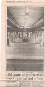
Newspaper, The Age, Progress Press, "Old trams to get boost as depot reaches end of line", 1998
Set of 11 newspaper cuttings about the planning for the Hawthorn Tram Museum Depot and the redevelopment of the site to apartments. .1 - The Age - 14/8/1998 - "Old trams to get boost as depot reaches end of line", featuring comments from the Minister for Transport Robin Cooper, quotes Michael Norbury. Has a photo of Senior Trainer Margaret Drew at the Southbank depot sitting inside tram V 214. Article by Lyall Johnson, photo by Luis Ascui. .2 - Progress Press - 17/8/1998 - "Site sale plan to fund new museum" - notes Urban Land Corporation .3 -The Age, 19/8/1998 - "Tram depot is saved by the bell" - about the proposed redevelopment - article by Paul Robinson, photo of the building by Sebastian Costanzo. .4 - Progress Press - 2/11/1998 - "Doubt over tram depot" - George Svigos .5 - Progress Press - 2/11/1998 - "Vintage tram a turn up", about the ownership of Ballarat 36 by the City of Hawthorn. Also notes the Box Hill extensions. .6 - Progress Press - 16/11/1998 - "Tram depot plan on track" - about the depot development and the TMSV. Includes a photo of Rod Atkins at the depot. Article by George Svigos, photo Tony Gough. .7 - Progress Press - 16/11/1998 - "Tram plan looks a goer" - Now the Boroondara Council. .8 - Progress Press - 14/12/1998 - "Old depot plans call" - article by George Svigos .9 - Progress Press - 30/11/1998 - "the gravy tram - featuring W1 431 outside the Hawthorn Tram depot and the free historic tram service Camberwell junction for Christmas. .10 - Progress Press - 23/11/1998 - "Heritage tram junction jaunt" - see above. .11 - Inside Melbourne - 14/12/1998 - advertising the heritage tram service with V214 and 164.trams, tramways, hawthorn tram depot, tram museum, museums, minister for transport, city of hawthorn, ballarat, camberwell junction, vintage trams, tram 36, tram v214, tram w1 431 -
 Melbourne Tram Museum
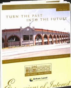
Document - Folder with papers, Urban Land corporation, "Hawthorn Tram Depot - Expressions of Interest Documentation", late 1998
White two spring clip folder with papers, titled "Hawthorn Tram Depot - Expressions of Interest Documentation", sub-titled "Turn the Past into the Future" Has a photo of Hawthorn Tram depot and an image on the front cover. Closing date 17/2/1999, prepared by the Urban Land Corporation with the assistance of VicTrack. Approx 110 pages with supplementary papers in the end covers. Contains a table of contents, checklist, EOI Process, Development Brief, Site conditions. Gives details of the heritage registration, site plans, building plans, property title and detailed room condition and use of the ground floor. Supplementary papers include the marketing brochure, letters and a detail feature and level survey by Bosco Johnson surveyors, 30-9-1998.trams, tramways, htt, hawthorn tram depot, sale of land, property -
 Melbourne Tram Museum
Newspaper, Herald Sun, "Let old trams die", 28/9/1993
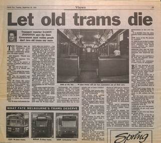
Article by Damon Johnston about Jeff Kennett and Melbourne's W class tram future including the development of a polity for their future. The reporter notes the lack of awareness for W class trams, compared to the general tram fleet, compares performance with Z class fleet. Quotes National Trust, PTUA and Charles Sowerwine of Melb. Uni urban historian. See item 7613 for the decision News Release.Yields information the formation of a policy regarding the W class in 1993 by Government.Newspaper clipping from Herald Sun 28/9/1993tramways, w class, national trust, tramcars -
 Bacchus Marsh & District Historical Society
Map, Plan of the second portion of the property of Messers Atkins and Clarke situate at Bacchus Marsh 1856
... provides some clues as to how the early urban development ...This plan of land allotments for sale indicates part of the property once owned by the Bacchus family in and around the township area of Bacchus Marsh. The Bacchus family sold their property in Bacchus Marsh to John Aitkins and Robert Nalder Clarke in March 1851. Aitkins and Clarke kept the property for a number of years until April 1856 when these allotments were put up for sale.This is a very early land sales plan for agricultural land close to the township of Bacchus Marsh. It therefore provides some clues as to how the early urban development of the township and agricultural development of the nearby area took place. Upon seeing the map in 1911 Bacchus Marsh Express newspaper editor Christopher Crisp wrote "The sale appears to have created the present township, which had a nucleus in earlier times further east", Express, 30 September, 1911, page 3.A single page paper plan showing allotments of land for sale. The subdivided land shown was owned by John Aitkins and Robert Nalder Clarke, but previously owned by the Bacchus Family and was in and around their Manor House (Mansion) property in Bacchus Marsh. This plan shows allotments in the second portion of land to be sold which was located east of the Manor House on the eastern side of the Lerderderg River. The land for sale was made up of 15 allotments. The plan is pasted into a bound volume containing 76 maps or plans in total. BMDHS Loc: AR/B12/S4 Bacchus Marsh Township and Nearby Districts Maps Volume In-house Digital copies: BMDHS, Computer Network: Maps\Bacchus Marsh Township and Nearby Districts Maps Volumebacchus marsh victoria maps, bacchus family, land sales, manor house bacchus marsh -
 Bacchus Marsh & District Historical Society
Map, Plan of the property of Messers Atkins and Clarke to be sold at the Mansion, Bacchus Marsh 19th April 1856. Copy 1
... the early urban development of the township took place. Upon seeing ...This plan of land allotments for sale indicates the property once owned by the Bacchus family in and around the township area of Bacchus Marsh. The Bacchus family sold their property in Bacchus Marsh to John Atkins and Robert Nalder Clarke in March 1851. Atkins and Clarke kept the property for a number of years until April 1856 when these allotments were put up for sale.This plan is almost identical to another copy held by the Bacchus Marsh and District Historical Society, VC Record 452, BMDHS collection). This plan, VC Record 707 Copy 1, contains a little more detail overall than VC Record 452 Copy 2, such as who did the survey work for the plan (R.C. Bagot) and who the selling agents were, (W.M. Tennent), and on the right side of the plan near the Lerderderg River is indicated the general area for a second parcel of land from this sale which is to be sold. There is also a compass illustration indicating north and south compass points.This is a very early land sales plan for the township of Bacchus Marsh and it therefore provides some clues as to how the early urban development of the township took place. Upon seeing the map in 1911 Bacchus Marsh Express newspaper editor Christopher Crisp wrote "The sale appears to have created the present township, which had a nucleus in earlier times further east", Express, 30 September, 1911, page 3.A single page paper plan showing allotments of land for sale. The subdivided land shown was owned by John Atkins and Robert Nalder Clarke, but previously owned by the Bacchus Family and was in and around their Manor House (Mansion) property in Bacchus Marsh.There are 5 portions of land further divided into numerous small portions. The land for sale is bounded by the present day streets of Main Street, Young Street, McFarland Street, Morton Streets, Crook Street, and part of the eastern section extends to the Lerderderg River. Scale: 8 chains to 1 inch The plan is pasted into a bound volume containing 76 maps or plans in total. BMDHS Loc: AR/B12/S4 Bacchus Marsh Township and Nearby Districts Maps Volume In-house Digital copies: BMDHS, Computer Network: Maps\Bacchus Marsh Township and Nearby Districts Maps VolumeHeading: Plan of the first portion of land. The property of Messers Atkins and Clarke situate at Bacchus Marsh. To be sold by W.M. Tennent & Co. at the Mansion on the Ground on Saturday the 19th April 1856. Below heading: Jas Ferguson, Lithographer On upper right side: Subdivided by R.C. Bagot London and Liverpool Chambers, Melbourne. 'Thos Taubman'. Post Office Stamp: BACCHUS MARSH VICTORIA MY 6, 63bacchus marsh victoria maps, bacchus family, land sales, manor house bacchus marsh -
 Mission to Seafarers Victoria
Photograph - Digital Image, series
This chapter consists of in-depth case studies of two location-based games played in Melbourne: Urban Codemakers (2010–11) and Wayfinder Live (2017), both designed by Troy Innocent. These games were directly funded by government bodies in Melbourne to promote the city’s cultural and artistic life to residents and tourists. But its creator was given a broad remit to fulfil these agendas and used them to reflect on the city’s history, architecture, and future development. Through auto-ethnographic observation and interviews with the designer and several players of the games, I reflect on the broader relationship between location-based games, their players, and the institutions and authorities that fund and enable them.Three of the mosaics were installed on outside walls of the Mission and were a way for the Mission to be put on the map.6 photographs depicting the Wayfinders mosaics to be scanned though an application on a phone.wayfinder, ludea, melbourne, on the map, marketing, application, cultural events -
 Port Melbourne Historical & Preservation Society
Book, Ministry of Planning & Environment, South Melbourne's Heritage, Dec 1988
Based on "City of South Melbourne Urban Conservation Study". Covers 1930s - 1960s.Paperback, illustrated guide to the history and development of South Melbourne "South Melbourne's Heritage" A4 sized book with coloured cover and blurred style picture of two women and children on Kerferd road pier in 1890s. Victoria Hotel in background. Book contains small black and white photos of buildings with descriptionsemerald hill, town planning, heritage, city of south melbourne -
Canterbury History Group
Document - Plan fears, Progress Leader, February 18 2002
a letter to Editor on plan fears of development of "Shrublands". Includes a concise history and description of the early history of the property. The letter also signals intentio s to fight to save the property.Peter and Robin Adams of Balwyn Road, Canterbury, sparked a successful campaign to save Shrublands. See also #1071.shrublands, balwyn road, carter>ernest, vineyards, urban planning -
 Broadmeadows Historical Society & Museum
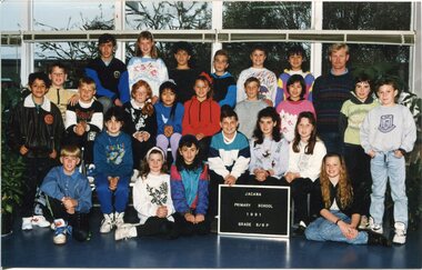
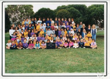
Photograph - Class Photograph, Jacana Primary School: Grade 5/6P, 1991, 1991
This 1991 group photograph of Grade 5/6 students and their teacher at Jacana Primary School provides a vivid snapshot of suburban school life in Melbourne during a time of notable social and urban transformation. Established in 1959, Jacana Primary served as a vital educational and community hub until its closure in the early 2000s. More than a place of learning, the school fostered a strong sense of identity, belonging, and shared experience among its students and staff. The image reflects the school’s commitment to nurturing inclusive and supportive environments for young learners. It also subtly documents the growing cultural diversity of Jacana in the late 20th century, as suburban development brought together families from a wide range of backgrounds. As part of the school’s visual archive, this photograph contributes to a broader understanding of how public education helped shape community identity, promote social cohesion, and influence the lives of generations of children and families.This 1991 class photograph of Grade 5/6 students and their teacher at Jacana Primary School is a historically significant artifact that captures a moment in time within a vibrant and evolving suburban community. Taken during a period of considerable social and urban change in Melbourne’s northern suburbs, the image reflects the school’s enduring role as a centre of education, inclusion, and community connection. Jacana Primary School, established in 1959 and closed in the early 2000s, was more than an academic institution—it was a place where children from diverse backgrounds came together, forming lasting relationships and shared memories. The photograph documents the increasing cultural diversity of the Jacana area in the late 20th century, offering insight into how public schools adapted to and reflected broader societal shifts. As part of the school’s visual archive, this image contributes to the historical narrative of public education in Victoria. It highlights the importance of schools as social anchors, fostering identity, cohesion, and continuity across generations. Its preservation ensures that the legacy of Jacana Primary School—and the community it served—remains visible and valued. Colour Photograph on Satin PaperBack: Top Left Corner: (Blue Label): PH-5500, Centre (in pencil) jacana primary school, education, photograph, group photograph, class photograph, andrew martins, karen marks, gunduz tabag, jayson sharman, jodi carroll, freda nguyen, houssein houssein, ross coats, andrew jenkins, debbie miller, tien huynh, lisa schewtschuk, alan stewart, salina leung, carrie lewis, brett chapman, peita anderson, danny borland, belinda norman, rebecca horton, mark layton, vicki bell, nahed elwohamed, shar-rena fitzgerald, mr. b. o'dea, mr. g. payne, grade 5/6p, 1991 -
 Broadmeadows Historical Society & Museum
Photograph - Class Photograph, Jacana Primary School: Students and Staff, 1996, 1996
... -war migration and urban development. As part of the school’s ...This 1996 class photo of students and their teachers at Jacana Primary School offers a vivid glimpse into suburban school life in Melbourne during a period of significant social and urban change. Founded in 1959, Jacana Primary played a central role in the community, serving as both an educational institution and a gathering place until its closure in the early 2000s. It was more than just a school—it was a space where students and staff built a strong sense of identity, connection, and shared experience. The photograph highlights the school’s dedication to creating an inclusive and nurturing environment for young learners. It also quietly captures the increasing cultural diversity of Jacana in the late 20th century, as suburban expansion brought together families from varied backgrounds. As part of the school’s visual history, this image helps illustrate how public education contributed to shaping community identity, fostering social cohesion, and influencing the lives of generations of children and their families.This 1996 class photograph from Jacana Primary School holds historical, social, and cultural significance as a visual record of suburban education in Melbourne during a time of dynamic transformation. Capturing students and their teacher, the image reflects the school’s role as a cornerstone of community life from its founding in 1959 until its closure in the early 2000s. The photograph is a testament to the inclusive and supportive learning environment fostered at Jacana Primary, illustrating the school’s commitment to nurturing young minds and promoting a sense of belonging. It also serves as a subtle yet powerful document of the increasing cultural diversity in Melbourne’s northern suburbs, shaped by post-war migration and urban development. As part of the school’s visual archive, this image contributes to a broader understanding of how public education helped shape local identity, foster social cohesion, and influence the lives of generations of children and families. It stands as a meaningful artifact of community memory and educational heritage.Colour Photograph mounted on white card, and laminatedBack: Top Left Corner: (Blue Label): PH-1221jacana primary school, education, photograph, group photograph, class photograph, 1996 -
 Broadmeadows Historical Society & Museum
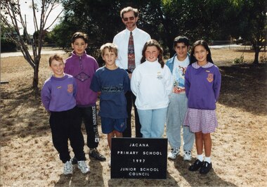
Photograph - Group Photograph, Fotek School Portraits, Jacana Primary School: Junior School Council, 1997, 1997
This 1997 photograph of students and a staff member from the junior student council at Jacana Primary School offers a compelling glimpse into suburban school life in Melbourne during a time of considerable social and urban change. Founded in 1959, Jacana Primary served as a vital educational and community institution until its closure in the early 2000s. More than a place of learning, the school was a foundation for building identity, connection, and shared experience among students and staff. The image highlights the school’s emphasis on student leadership and participation, reflecting its commitment to fostering an inclusive, empowering, and supportive environment for young learners. It also subtly documents the increasing cultural diversity of Jacana in the late 20th century, as suburban growth brought together families from a wide range of backgrounds. As part of the school’s visual archive, this photograph contributes to a broader understanding of how public education shaped local identity, encouraged civic engagement from an early age, and promoted social cohesion. It stands as a meaningful record of the school’s legacy and its lasting impact on the lives of children and their communities.The 1997 photograph of the junior student council at Jacana Primary School is a culturally and historically significant record that reflects the values and dynamics of suburban education in Melbourne during a period of notable social and urban transformation. Capturing a moment of student leadership and engagement, the image highlights the school’s commitment to fostering inclusive, participatory learning environments where young voices were encouraged and empowered. Jacana Primary School, established in 1959 and active until its closure in the early 2000s, served as a vital educational and community hub in Melbourne’s northern suburbs. This photograph not only documents the school’s emphasis on student representation but also subtly illustrates the increasing cultural diversity of the Jacana area in the late 20th century, shaped by migration and suburban development. As part of the school’s visual archive, the image contributes to a broader understanding of how public education helped shape community identity, promote social cohesion, and instill civic values in younger generations. It stands as a meaningful artifact of educational heritage and community memory.Colour Photograph mounted on white card, and laminatedBack: Top Left Corner: (Blue Label): PH-2187, (Front): (Bottom Left corner): Fotek Portraits © Photograph (Back): (Dispersed): Fujifilmjacana primary school, education, photograph, group photograph, 1997, junior school council -
 Broadmeadows Historical Society & Museum
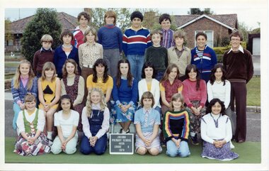
Photograph - Class Photograph, Jacana Primary School: Grade 6, 1979, 1979
This 1979 group photograph of Grade 6 students and their teacher at Jacana Primary School offers a valuable window into the everyday rhythms of school life in Melbourne’s northern suburbs during a time of notable social and urban transformation. Established in 1959, Jacana Primary served as a key educational and social institution until its closure in the early 2000s. Beyond its academic role, the school fostered a strong sense of place, belonging, and shared experience among its students and staff. The image reflects Jacana Primary’s commitment to creating inclusive and supportive learning environments. It also subtly documents the growing cultural diversity of the Jacana area in the late 20th century, as suburban development brought together families from a range of backgrounds. As part of the school’s visual archive, this photograph contributes to a broader understanding of how public schools helped shape community identity, promote social cohesion, and influence the lives of generations of children and families.This 1979 group photograph of Grade 6 students and their teacher at Jacana Primary School is a historically significant artifact that documents the educational and social landscape of Melbourne’s northern suburbs during a period of rapid urban and demographic change. As a visual record of a public school community, the image reflects the values, diversity, and everyday experiences of students and educators in the late 20th century. Jacana Primary School, established in 1959 and closed in the early 2000s, played a foundational role in shaping the identity and cohesion of the Jacana community. The photograph captures not only the individuals present but also the inclusive and supportive environment that the school fostered. It offers insight into the evolving cultural fabric of the suburb, as families from varied backgrounds came together through shared educational experiences. The image is significant for its contribution to understanding how public schools functioned as social anchors—promoting belonging, continuity, and collective memory. It serves as a testament to the enduring impact of local education on community development and the lives of generations of children and families.Colour Photograph on Matte Paper, with white borderBack: Top Left Corner: (White label): PH-5012/ (Blue Label): PH-5599, Centre (in pencil) J.P.S., Manufacturers Mark; this paper/Manufactured/ by kodakjacana primary school, education, photograph, group photograph, 1979, class photograph, grade 6 -
Port Melbourne Historical & Preservation Society
Book, Kate Shaw et al, Ewan Ogilvy's Bayside Papers, Box Three - Bayside Views - A Collection of critical perspectives on the Bayside Development, 1988
Ewan OGILVY, former Melbourne Councillor and also of Community Services Victoria, Inner Urban Ministerial Advisory Committee and Uniting Church's Centre for Urban Research and Action (CURA), was instrumental in social justice approaches to town planning. He and CURA's Social Justice and the City Project funded Port Melbourne community groups protesting against the SCDC development in 1987. His files were presented to the Society in May 2001 on his preparation for leaving Victoria.From Ewan OGILVY'S chronologically organised 'Bayside Papers' relating to the proposed development of Port Melbourne industrial land in the late 1980s: Bayside Views - A Collection of critical perspectives on the Bayside Development, a book of essays on Bayside issues, 1988 - funded by the Justice in the City projectSigned 'Ewan Ogilvy'town planning, town planning - proposals shelved - bayside, public action campaigns, environmental issues, public housing, missions to seamen, centre for urban research and action (cura), uniting church, sandridge city development co pty ltd, scdc, linton r lethlean, barry pullen, ewan ogilvy -
 Broadmeadows Historical Society & Museum
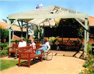
Photograph, Meeting under the Pergola to Chat, Banksia Gardens, 1998, 3 February 1998
"Meeting Under the Pergola to Chat" is part of the Banksia Gardens collection from 1998. It captures a moment of social interaction within a public space designed for residents of social housing to meet and engage with their neighbours. This image highlights the significance of communal areas in fostering a sense of community and belonging among residents. The pergola serves as a focal point for social gatherings, reflecting the thoughtful urban planning aimed at enhancing social cohesion and quality of life in the housing development during that period.The photograph titled "Meeting Under the Pergola to Chat" is part of the Banksia Gardens collection from 1998. It depicts social housing with public spaces designed for neighbours to meet and interact. This image captures the essence of community life and the importance of shared spaces in fostering social connections within the housing development. The photograph not only documents the architectural and social planning of the era but also highlights the value placed on communal areas for enhancing the quality of life for residents.Colour photograph on glossy photographic paper."Pergola where neighbours meet to chat, Public Housing"/"Banksia Gardens 1998"social housing, banksia gardens, pergola, meeting place, 1998 -
 Broadmeadows Historical Society & Museum
Photograph, Construction of Access Road, Banksia Gardens, c 1980s
This item depicts the construction of the Access Road to Banksia Gardens, The photograph captures a significant moment in the development of the Banksia Gardens housing project, highlighting the infrastructure improvements aimed at enhancing accessibility and connectivity within the community. The construction of the access road was a crucial step in the urban planning process, facilitating easier movement for residents and contributing to the overall development and integration of the housing estate.This item, showing the construction of the Access Road to Banksia Gardens, holds significant historical value. It documents a pivotal moment in the development of the Banksia Gardens housing project, illustrating the efforts to improve infrastructure and accessibility within the community. The construction of the access road was a key component in the urban planning strategy, aimed at enhancing connectivity and facilitating the movement of residents. This development not only improved the practical aspects of daily life for the community but also symbolised progress and growth within the housing estate. The photograph serves as an important record of the planning and development processes that shaped the Banksia Gardens community.Poor quality black and white photograph on matte photographic paper.banksia gardens, broadmeadows, construction, access road, c 1980's -
 Narre Warren and District Family History Group
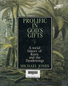
Book, MA Jones, Prolific in God's gifts : a social history of Knox and the Dandenongs, 1983
a detailed historical account of the Knox and Dandenong regions in Victoria, Australia. The book explores the area's development from the arrival of the first pastoralists to its transformation into part of urban Melbourne. It highlights key figures such as James Clow, a clergyman and pastoralist, and John Wood Beilby, an explorer and speculator. The book also discusses the region's early agricultural struggles, the impact of the railway, and its emergence as one of Australia's first tourist destinations. Richly illustrated with photographs and maps, it provides a vivid picture of the area's history through original newspaper excerpts and documents. [AI generated text]328 p.; 24 cmnon-fictiona detailed historical account of the Knox and Dandenong regions in Victoria, Australia. The book explores the area's development from the arrival of the first pastoralists to its transformation into part of urban Melbourne. It highlights key figures such as James Clow, a clergyman and pastoralist, and John Wood Beilby, an explorer and speculator. The book also discusses the region's early agricultural struggles, the impact of the railway, and its emergence as one of Australia's first tourist destinations. Richly illustrated with photographs and maps, it provides a vivid picture of the area's history through original newspaper excerpts and documents. [AI generated text]knox (vic.), dandenongs