Showing 8865 items
matching warrandyte road
-
 Ringwood and District Historical Society
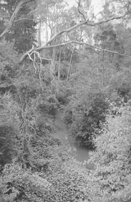
Photograph, Mullum Creek from bridge in Warrandyte Rd. Looking East 1970
... From bridge in Warrandyte Road. See DB Item 2957 for later... Creek 1970 from bridge" From bridge in Warrandyte Road. See DB ...From bridge in Warrandyte Road. See DB Item 2957 for later photo, same scene, with bridge identified.Typed below photograph, "Mullum Creek 1970 from bridge" -
 Ringwood and District Historical Society
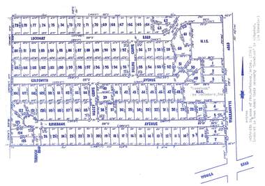
Map, Subdivision Plan - Rosebank Avenue area, North Ringwood, Vic. - circa 1960s
... "Rosebank" property, Warrandyte Road, Ringwood North. Subdivision..., Warrandyte Road, Ringwood North. Subdivision includes Through Road ...Single page plan printed on green background showing allotments included in un-named subdivision layout surrounding "Rosebank" property, Warrandyte Road, Ringwood North. Subdivision includes Through Road, Rosebank Avenue, Macey Grove, Goldsmith Avenue, Dillon Grove, Lockhart Road, and Warrandyte Road.Typewritten notation against "Rosebank" property - "Mrs Godbehear, Snr.". "Goldsmith is maiden name of Mrs. Godbehear, Senior. (1960). Lockhart is town where their property "Rosebank" is situated. (In Riverina)". -
 Ringwood and District Historical Society
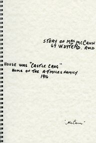
Book, Mrs. McCann
... Story of Mrs McCann 69 Warrandyte Road Ringwood - House... Road Ringwood North melbourne Story of Mrs McCann 69 Warrandyte ...Story of Mrs McCann 69 Warrandyte Road Ringwood - House was "Castle Crag" home of The A.T Miles family in 1916 -
 Ringwood and District Historical Society
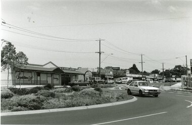
Photograph, Ringwood black and white photographs
... Nth Ringwood shopping centre at Oban & Warrandyte Roads... at Oban & Warrandyte Roads Black and white photograph Ringwood ...Black and white photographNth Ringwood shopping centre at Oban & Warrandyte Roads -
 Ringwood and District Historical Society
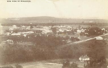
Photograph, View of Ringwood in 1912 taken from Loughnan's Hill
... Street. Warrandyte Road is above it."... is in Adelaide Street. Warrandyte Road is above it." House bottom RH... Street. House on left is in Adelaide Street. Warrandyte Road ...Black and white photograph looking across valley with small settlement. Mountains in background. (2 postcard copies and 2 enlargements). House in right foreground is in what is known now as Wildwood Grove. The dirt track above is Ringwood St. Field above is the football field with diagonal track coming out at Melbourne Street, later Eastland shopping complex. House on left is in Adelaide Street. Warrandyte Road is above it."Typed on back of one enlargement, "Copied from a postcard mailed in Ringwood, 1912, copied 1959. House in right foreground is in what is known now as Wildwood Grove. The dirt track above is Ringwood St. Field above is the present football field with diagonal track coming out at Melbourne Street. House on left is in Adelaide Street. Warrandyte Road is above it." House bottom RH side was still there in 1970 in Wildwood Grove (off Ringwood St). Ringwood Street lower centre to RH side. Field above Ringwood Street is the football field with diag. walk coming out at Melbourne Street. House on LH side in Adelaide Street. Warrandyte above it. Steam at LH from Bently's Steam Joinery at corner Main Street and Warrandyte Road. -
 Ringwood and District Historical Society
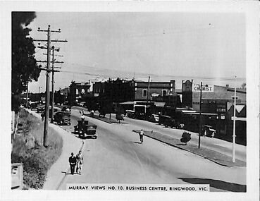
Photograph/Postcard, Souvenir photograph - Murray Views No.10. Business Centre, Ringwood, Vic
... Warrandyte Road looking west along Maroondah Highway, Ringwood..." souvenir photograph from Warrandyte Road looking west along ...Black and white "Murray Views" souvenir photograph from Warrandyte Road looking west along Maroondah Highway, Ringwood. Circa 1940s. -
 Ringwood and District Historical Society
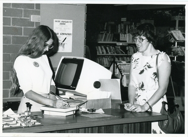
Photograph, Richard Steward, Ringwood Studios, Ringwood Library
... -held scanner at City of Ringwood Library, 28 Warrandyte Road, c... Library, 28 Warrandyte Road, c.1974. Ringwood Library Photograph ...Photograph of librarian checking out books using a hand-held scanner at City of Ringwood Library, 28 Warrandyte Road, c.1974. -
 Whitehorse Historical Society Inc.
Document, German smoked sausage, n.d
... Warrandyte Road, Donvale.... it was used. Written by Oriel Hoffman of 9 Old Warrandyte Road ...Recipe for German Smoked Sausage plus description of the smokehouse and how it was used. Written by Oriel Hoffman of 9 Old Warrandyte Road, Donvale.smoked sausages, smokehouses -
 Ringwood and District Historical Society
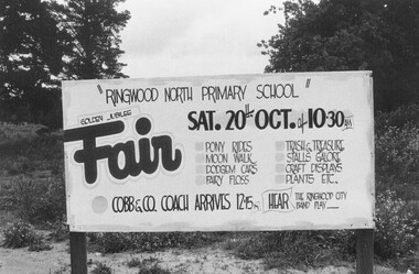
Photograph, Ringwood North Primary School Fair - Sign at corner Oban and Warrandyte Roads, North Ringwood. (undated, but possibly 1984)
... and Warrandyte Roads"...., "Sign at corner Oban and Warrandyte Roads". Golden Jubilee Fair ...Golden Jubilee Fair sign. Sat 20th Oct. No year, but most likely year with this date is 1984, when a number of photos in this area were taken by RDHS.Written on back of photograph, "Sign at corner Oban and Warrandyte Roads". -
Ringwood and District Historical Society
Memorabilia - Envelope, Packet: Ringwood R.S.L. and Clocktower - Letters, Clippings. Packet 2
... of the clocktower from Warrandyte Road... regarding the move of the clocktower from Warrandyte Road Packet ...Packet 2 of 3 Ringwood RSL documents - Clocktower; Packet containing mainly newspaper clippings regarding the move of the clocktower from Warrandyte Road -
 Eltham District Historical Society Inc
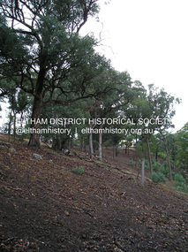
Photograph, Fay Bridge, Longridge, Alexander Road, Warrandyte, 4 May 2019
... Longridge, Alexander Road, Warrandyte... Glynns Longridge Ruins Warrandyte 2019-05-04 Alexander Road 23 ...Situated on the Warrandyte side of the Yarra River opposite Glynn's Dairy Farm, North Warrandyte, the property is in ruins and remains fenced off as of 2023fay bridge collection, glynns, longridge, ruins, warrandyte, 2019-05-04, alexander road -
 Ringwood and District Historical Society
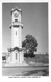
Photograph/Postcard, Postcard - Murray Views No.2 - Ringwood Main St and Clocktower in original position
... clock tower, cnr Maroondah Highway & Warrandyte Road, looking..., cnr Maroondah Highway & Warrandyte Road, looking south towards ...Black and white "Murray Views" postcard - Ringwood memorial clock tower, cnr Maroondah Highway & Warrandyte Road, looking south towards railway line.Front: "Murray Views No. 2 Memorial Clock, Ringwood, Vic." Back: "1948" handwritten. "Real Photograph Produced in Australia by Murray Views, Gympie, Q." -
 Ringwood and District Historical Society
Photograph, Construction of newly relocated Ringwood Gospel Church in Tamar Street, Ringwood - 1974
... being built in 1974. Previously the church was in Warrandyte...Ringwood and District Historical Society 125A Warrandyte ...The newly located Gospel Church in Tamar Street Ringwood being built in 1974. Previously the church was in Warrandyte Road, Ringwood, since absorbed as part of Eastland.Written on back of photograph, "5.10.74". -
 Eltham District Historical Society Inc
Photograph - Digital Photograph, Alan King, Pigeon Bank, one of the Nillumbik shire's oldest farm dwellings, 6 February 2008
... Kangaroo Ground-Warrandyte Road... Francis Rogerson Kangaroo Ground Kangaroo Ground-Warrandyte Road ...In 1848, Francis Rogerson form Dumfriesshire, Scotland purchased 80 acres of land at Kangaroo Ground on which he built a two-roomed bark hut. He named the property afterr the many Bronzewings and Wonga Pigeons in the area. Ewen Hugh Cameron moved to Pigeon Bank the same year he was elected to Parliament as the Member for Evelyn. At the time he moved in, Pigeon Bank had six rooms and the present water well. He made further extensive additions and lived there until his death in 1915. Covered under Heritage Overlay, Nillumbik Planning Scheme. Published: Nillumbik Now and Then / Marguerite Marshall 2008; photographs Alan King with Marguerite Marshall.; p27This collection of almost 130 photos about places and people within the Shire of Nillumbik, an urban and rural municipality in Melbourne's north, contributes to an understanding of the history of the Shire. Published in 2008 immediately prior to the Black Saturday bushfires of February 7, 2009, it documents sites that were impacted, and in some cases destroyed by the fires. It includes photographs taken especially for the publication, creating a unique time capsule representing the Shire in the early 21st century. It remains the most recent comprehenesive publication devoted to the Shire's history connecting local residents to the past. nillumbik now and then (marshall-king) collection, ewen hugh cameron, francis rogerson, kangaroo ground, kangaroo ground-warrandyte road, pigeon bank -
 Eltham District Historical Society Inc
Photograph - Black and White Print, Old settler's cottage, Floods Lane, North Warrandyte, c.1935
... Kangaroo Ground-Warrandyte Road... Road off Kangaroo Ground-Warrandyte Rd near boundary of North... Road off Kangaroo Ground-Warrandyte Rd near boundary of North ...An early settler's cottage of 1920s vintage near Floods Rd taken in the 1930s. Was originally Floods Lane and became Floods Road off Kangaroo Ground-Warrandyte Rd near boundary of North WarrandyteInscribed in pencil on reverse "early 20's near Flood Rd taken 30's. 21/1.89" and in pen ".16/1.80"cottage, floods lane, floods road, houses, kangaroo ground-warrandyte road, north warrandyte, pioneers -
 Eltham District Historical Society Inc
Slide, Brenda Street, Research, May 1983
... Research-Warrandyte Road... research (vic.) Brenda Street Research-Warrandyte Road 35 mm colour ...One of a series of images of roads and infrastructure taken by Eltham Shire Council Planning and Engineering officers, May 1983 specifically looking at road conditions and drainage in Research (Vic.) around Thompson Crescent.35 mm colour positive transparency (1 of 11) Mount - Kodak Kodachrome Cardroads, infrastructure, research (vic.), brenda street, research-warrandyte road -
 Eltham District Historical Society Inc
Slide, Brenda Street, Research, May 1983
... research-warrandyte road... research (vic.) brenda street research-warrandyte road 35 mm colour ...One of a series of images of roads and infrastructure taken by Eltham Shire Council Planning and Engineering officers, May 1983 specifically looking at road conditions and drainage in Research (Vic.) around Thompson Crescent.35 mm colour positive transparency (1 of 11) Mount - Kodak Kodachrome Cardroads, infrastructure, research (vic.), brenda street, research-warrandyte road -
 Eltham District Historical Society Inc
Slide - Photograph, Eltham-Yarra Glen Road, Kangaroo Ground, c.Mar. 1989
... Kangaroo Ground-Warrandyte Road...-Warrandyte Road Presbyterian Church Process Date MAR 89M 35mm colour ...35mm colour positive transparency (1 of 28) Mount - Kodak KodachromeProcess Date MAR 89Mkangaroo ground, donaldson road, eltham-yarra glen road, kangaroo ground state school, kangaroo ground store, kangaroo ground-warrandyte road, presbyterian church -
 Eltham District Historical Society Inc
Slide - Photograph, Memorial Park, Garden Hill, Kangaroo Ground, c.1993
... Kangaroo Ground-Warrandyte Road...-Warrandyte Road Memorial Park Shire of Eltham War Memorial 35mm ...35mm colour positive transparency Mount - Black and Whitegarden hill, kangaroo ground tower, kangaroo ground-warrandyte road, memorial park, shire of eltham war memorial -
 Eltham District Historical Society Inc
Photograph, Leader Publishing Co, Pigeon Bank, Kangaroo Ground, 1971
... Kangaroo Ground-Warrandyte Road... houses Kangaroo Ground-Warrandyte Road Digital image Print 12.5 x ...Home built prior to 1860 for Francis Rogerson and later owned by Ewen Cameron who was the local Parliamentarian. In 1971 it was home of Mr. and Mrs. Menzies Jackson. The home is listed on the Victorian Heritage Database. This photo forms part of a collection of photographs gathered by the Shire of Eltham for their centenary project book, "Pioneers and Painters: 100 years of the Shire of Eltham" by Alan Marshall (1971). The collection of over 500 images is held in partnership between Eltham District Historical Society and Yarra Plenty Regional Library (Eltham Library) and is now formally known as the 'The Shire of Eltham Pioneers Photograph Collection.' It is significant in being the first community sourced collection representing the places and people of the Shire's first one hundred years.Digital image Print 12.5 x 17.5 cm Print 9 x 14 cmsepp, shire of eltham pioneers photograph collection, kangaroo ground, menzies jackson, pigeon bank, houses, kangaroo ground-warrandyte road -
 Ringwood and District Historical Society
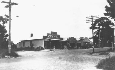
Photograph, Milnes store, corner Oban and Warrandyte Roads, 1950
... and Warrandyte Roads, 1950".... store, corner Oban and Warrandyte Roads, 1950". Milnes store ...Typed below photograph, "Milnes store, corner Oban and Warrandyte Roads, 1950". -
 Ringwood and District Historical Society
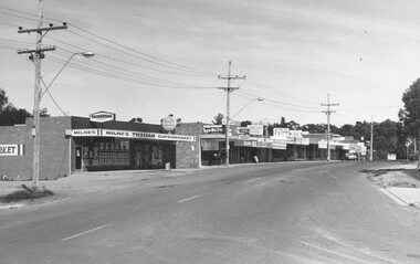
Photograph, Milnes store, corner Oban and Warrandyte Roads, 1973
... and Warrandyte Roads, 1973".... store, corner Oban and Warrandyte Roads, 1973". Milnes store ...Typed below photograph, "Milnes store, corner Oban and Warrandyte Roads, 1973". -
 Ringwood and District Historical Society
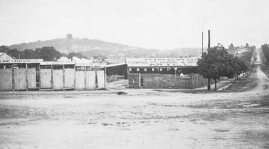
Photograph, Maroondah Highway Central, Ringwood. Bamford's Timber Yard, c1920
... of Warrandyte Road and Main Street".... of Warrandyte Road and Main Street". 2 copies of photograph (1 black ...2 copies of photograph (1 black and white, 1 smaller sepia)Written on back of photograph: "Bamford, west corner of Warrandyte Road and Main Street". -
 Ringwood and District Historical Society
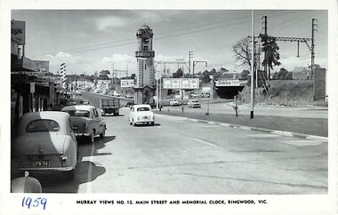
Photograph/Postcard, Postcard - Murray Views No.12. Main Street and Memorial Clock, Ringwood, Vic
... looking east towards Memorial Clock Tower on Warrandyte Road... looking east towards Memorial Clock Tower on Warrandyte Road ...Black and white "Murray Views" postcard - Maroondah Highway looking east towards Memorial Clock Tower on Warrandyte Road intersection; railway bridge on right. Circa 1959."1959" handwritten on front. -
 Ringwood and District Historical Society
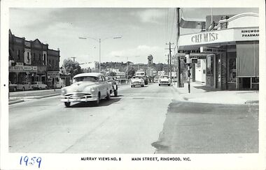
Photograph/Postcard, Postcard - Murray Views No.8 - Main Street, Ringwood, Vic
... . Clocktower on Warrandyte Road corner. Circa early 1960s.... on Warrandyte Road corner. Circa early 1960s. Postcard - Murray Views ...Black and white "Murray Views" postcard - Eastward view from Railway Station Entrance along Maroondah Highway, Ringwood. Clocktower on Warrandyte Road corner. Circa early 1960s.1959 handwritten on front and back is incorrect - Early 1960s model cars in view. -
 Ringwood and District Historical Society
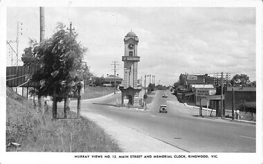
Photograph/Postcard, Postcard and souvenir photograph - Murray Views No.12. Main Street and Memorial Clock, Ringwood, Vic
... . Warrandyte Road and Maroondah Highway, Ringwood, Vic. Circa late..., looking west from cnr. Warrandyte Road and Maroondah Highway ...Black and white "Murray Views" postcard and souvenir photograph - Ringwood Memorial Clocktower, looking west from cnr. Warrandyte Road and Maroondah Highway, Ringwood, Vic. Circa late 1940s.Printed on back - Post Card - Real Photographs produced in Australia by Murray Views, Gympie, Q. Handwritten - "1949 or 48". -
 Ringwood and District Historical Society
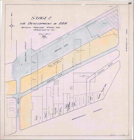
Map, Development of Right of Way Stage 2, Ringwood, Victoria - 1950
... of Right of Way between Adelaide Street and Warrandyte Road... Street and Warrandyte Road, Ringwood, showing existing retail ...Borough Engineer's technical drawing for Development of Right of Way between Adelaide Street and Warrandyte Road, Ringwood, showing existing retail establishments and outbuildings, and area available for lock-up shops.Scale 20' = 1". ACR 11.7.50. (Alan Charles Robertson - Borough Engineer) -
 Ringwood and District Historical Society
Photograph, Composite Aerial Views of Ringwood, Victoria - 1972
... , Bedford Road, Ringwood Street, Warrandyte Road, Mullum Road..., Bedford Road, Ringwood Street, Warrandyte Road, Mullum Road ...Two composite black & white aerial photographs with north-facing view over Maroondah Highway, including Railway Station precinct, Civic Centre precinct, Eastland, Mount Dandenong Road, Bedford Road, Ringwood Street, Warrandyte Road, Mullum Road, Loughnan's Road.Department of Crown Lands and Survey. Maroondah Highway Project - Run 3 - 20.1.72 - 3,900' ASL. -
 Ringwood and District Historical Society
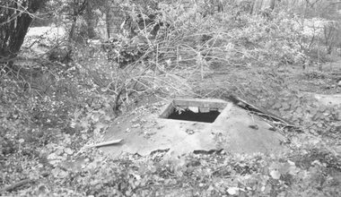
Photograph, Well rear old house corner Oban and Warrandyte Roads, 1964
... and Warrandyte Roads, 1964".... rear old house corner Oban and Warrandyte Roads, 1964". Well ...Written on backing sheet, "Well rear old house corner Oban and Warrandyte Roads, 1964". -
 Ringwood and District Historical Society
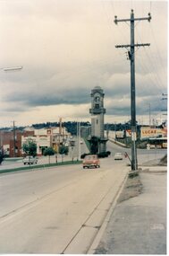
Photograph, Ringwood Clocktower - circa 1960's
... , middle of Maroondah Highway and Warrandyte Road intersection.... and Warrandyte Road intersection. Postcard size colour photograph ...Postcard size colour photograph'Written on back of photograph" Clock Tower - original site, middle of Maroondah Highway and Warrandyte Road intersection.