Showing 1144 items
matching west side
-
 Ringwood and District Historical Society
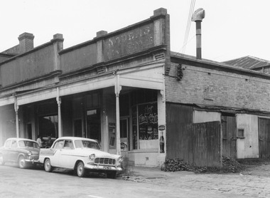
Photograph, Edwin G. Adamson A.R.P.S, Building fronting Adelaide St. Ringwood, buildings being portion of those known as 'The Block' 1963 (Eastland Litigation Photo)
... as 'The Block'. Photo showing shops on the west side of Adelaide St... shops on the west side of Adelaide St., near its junction ...This series of SS0380 photos are part of the "Eastland Litigation" launched in 1962 by the Whitehorse Traders Co-operative Association (WTCA), against the Ringwood Council's Interim Development Order of 1960. WTCA sought "orders from the Supreme Court of Victoria that the planning scheme was invalid" - See "The Eastland Litigation" chapter in "From Horse Shoes to High Heels - Ringwood Shopping Centre and Eastland 1858-2008" by Richard Carter, Bounce Books 2009.Written on back of photograph, 'Photo of the building fronting Adelaide St., buildings being portion of those known as 'The Block'. Photo showing shops on the west side of Adelaide St., near its junction with Maroondah Highway.. Fish and Chip shop" Stamped on photograph, 'In the Supreme Court 13 Aug. 1983' and 'Edwin G. Adamson...May 62'. -
 Whitehorse Historical Society Inc.
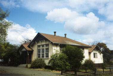
Photograph, Vermont Primary School No 3133, 1980's
... was erected on 1872. In 1907 a room was built onto the west side... the west side of the building and a new classroom and cloakroom ...The first of the Vermont Primary School buildings was erected on 1872. In 1907 a room was built onto the west side of the building and a new classroom and cloakroom were erected in 1922. Due to rising numbers and traffic volume, Vermont Progress Association urged the government to relocate the school buildings to a less prominent site, and new school buildings were erected in Nurlendi Street in the 1950's. The original timber building remained on the site until its removal to the Nurlendi Street site in the 1990's, and is on the city of Whitehorse Heritage Review.Coloured photograph of the Vermont Primary School while it was standing vacant from the 1950's until 1989 when it was moved to the main school in Nurlendi Road, Vermont. The school was on the North West corner of Canterbury and Mitcham roads facing Mitcham Road. Canterbury Road can be seen through the trees at the left of the photograph.vermont primary school no 3133, primary schools -
 Port Melbourne Historical & Preservation Society
Photograph - Bay Street shops, Charles Nettleton, Charles Nettleton, 1890s
... showing west side of Bay Street: Collings & Son, Butcher; Cranston...:- original Charles NETTLETON print showing west side of Bay Street ...This photograph was taken by Charles NETTLETON (1826-1902), a prominent Melbourne photographer who recorded the city’s rapid growth from a small town into a metropolis. He was the special photographer for the government and the Melbourne Corporation, and documented of the built environment and major public works throughout Melbourne from when he arrived to Victoria in 1854. Nettleton is credited for having photographed the first Australian steam train, the Melbourne-Sandridge (Port Melbourne) line, which opened in 12 September 1854; the first cricket team to come to Australia on the ss Great Britain in 1861; and Ned KELLY while Nettleton worked as a police photographer.Bay Street shops, 1875:- original Charles NETTLETON print showing west side of Bay Street: Collings & Son, Butcher; Cranston, Paperhanger; Mrs T CLAY; Johnny ALLSORT's Pawn Office; H. DAVENPORT, Clothing; G. RANSOM, Hardware; A.E. AITKEN, Auctioneer; Mrs A. BROWN, Haberdashery; F.C. FORSTER; Marshal, Printer; John PARRY (or BARRY), General Store; E & M RICE. The house is on the site of the 1912 Post Officebuilt environment - commercial, charles nettleton, theresa clay, collings & son, cranston, h davenport, g ransom, alexander ebling aitken, mrs a brown, john parry, john barry, e & m rice, f c forster, johnny allsorts pawnbroker -
 Bendigo Historical Society Inc.
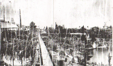
Photograph - LONG GULLY HISTORY GROUP COLLECTION: GEORGE LANSELLS FORTUNA, MINES & BATTERY
... and on the right is: Fortuna. Mining Days. Taken from West Side. Booth... Days. Taken from West Side. Booth St. Photograph LONG GULLY ...Copy of a black and white photo of George Lansells Fortuna, Mines & Battery. this photo is a continuation of the part a photo further to the right. In the photo is Fortuna and next to it is two chimneys, a raised trolleyway going to the poppet legs and some buildings. In front of the poppet legs and Fortuna is the lake. There are also more trees and shrubs. Written on the back left is: George Lansells Fortuna Mines & Battery Bendigo and on the right is: Fortuna. Mining Days. Taken from West Side. Booth St.bendigo, history, long gully history group, the long gully history group - george lansells fortuna, mines & battery -
Port Melbourne Historical & Preservation Society
Photograph - Photograph -Centenary Bridge stairway, Port Melbourne, 1991
... Colour photograph of Centenary Bridge stairway (west, beach... alison kelly Colour photograph of Centenary Bridge stairway (west ...Taken by Alison Kelly during the demolition years for 'Bayside' developmentColour photograph of Centenary Bridge stairway (west, beach side) through the gap under the bridge can be seen what remains of the Port Melbourne railway shunting yard. Mounted on grey paper.centenary bridge, built environment - civic, transport, alison kelly -
 Tatura Irrigation & Wartime Camps Museum
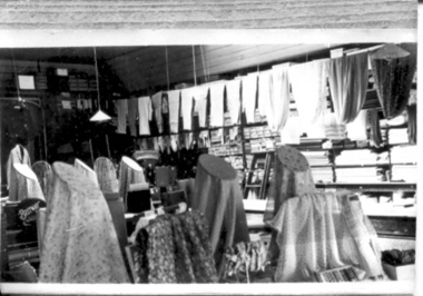
Photograph, Williams' Store Drapery Department
... , North side, West of Thomson Street. Opened 1880...., Drapery Department, Hogan Street, North side, West of Thomson ...Frank Williams' Store, Drapery Department, Hogan Street, North side, West of Thomson Street. Opened 1880.tatura, buildings, historic -
 Ringwood and District Historical Society
Book - Heathmont Shopping Strip, From Apples to a Second Coffee 2013-2024
... Contents: Area 1 - West side odd numbers - 95 Canterbury...Contents: Area 1 - West side odd numbers - 95 Canterbury ...Soft covered wire bound book. Sequel to earlier book titled The First 90 years of Heathmont Shopping Centre 1923-2013.Contents: Area 1 - West side odd numbers - 95 Canterbury Road down to trainline Area 2 - West side odd numbers - from trainline up to 165 Canterbury Road Area 3 - East side even numbers - from Allens Road down to laneway Area 4 - East side even numbers - from laneway down to trainline What cannot be purchased in Heathmont in 2024 Strip Series: annual changes 2014 to 2024 Covid pandemic 2019-2020 Future directions Current HHG and Heathmont publications list. Acknowledgements: Heathmont History Group members - Laurie Allen, David Gee, Gerry Robinson, Ray Stevens, Trevor Weir. Sketches by David Williams (dec.). Ringwood & District Historical Society. -
 Bendigo Historical Society Inc.
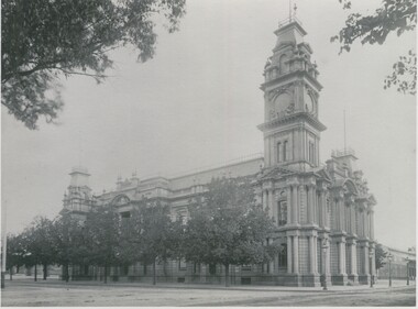
Photograph - TOWN HALL WITH OLD BENDIGO MARKET IN DISTANCE
... bottom right. Taken from Hargeaves St (West side) between Bull St... market bottom right. Taken from Hargeaves St (West side) between ...Black and white photograph. Town hall, old Bendigo market bottom right. Taken from Hargeaves St (West side) between Bull St and Mundy St. Inscriptions: on back - TR corner 'MP 258' (blue circular stamp), 'Royal Historical Society of Victoria, Bendigo Branch'. Typed adhesive label - 'Bendigo Historical Society Inc'. P No. 70 taken Hargreaves St. (Ian Wild, June 2000). History of object: previous Acc. No. 'MP 258'.cottage, miners -
Port Melbourne Historical & Preservation Society
Photograph - Bay Street shops, Charles Nettleton, 1890s
... showing west side of Bay Street: Collings & Son, Butcher; CRANSTON... showing west side of Bay Street: Collings & Son, Butcher; CRANSTON ...Bay Street shops, 1875:- original Charles NETTLETON print showing west side of Bay Street: Collings & Son, Butcher; CRANSTON, Paperhanger; Mrs T CLAY; Johnny ALLSORT's Pawn Office; H. DAVENPORT, Clothing; G. RANSOM, Hardware; A.E. AITKEN, Auctioneer; Mrs A. BROWN, Haberdashery; F.C. FORSTER; Marshal, Printer; John PARRY (or BARRY), General Store; E & M RIVE. The house is on the site of the 1912 Post Office. This is a copy of the larger original at B.11.09built environment - commercial, charles nettleton, theresa clay, collings & son, cranston, h davenport, g ransom, alexander ebling aitken, mrs a brown, john parry, john barry, e & m rice, f c forster, johnny allsorts pawnbroker -
 Wodonga & District Historical Society Inc
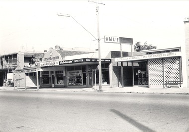
Photograph - Mann Collection Album - Terminus Hotel; Gippsland & Northern
... ). on the west side of High Street. The Terminus Hotel was built C. 1873... and Finance Company (A.M.L. & F). on the west side of High Street ...This photo is part of a collection of Wodonga Town Photos donated by Elaine Mann. Elaine was married to David Mann, a successful Wodonga businessman and community leader who passed away in Wodonga in June 2012. David was a member of the Mann family who began their business in Wodonga in 1920. Elaine was a teacher in Wodonga for many years and an active member of the community. The Terminus Hotel In 1873, James Thompson Hatch built the two-storeyed Terminus Hotel at 79 Sydney Road (later known as High Street), then sold it to George Day and Kenneth McLennan for £1,230. It was first licensed to J. G. Morton in January 1874. In 1879, Annie Allen, from Ireland, took over as licensee of the hotel containing 14 rooms, after she and her husband, George James Allen, purchased it. He became licensee in 1883. Under the Allens, the Terminus became, ‘a principal rendezvous for visitors to the town.’ September 1888 saw additions to the building that included a billiard room, a dining room, and 18 other rooms. Following the death of her husband in 1889, Annie Allen continued to run the Terminus Hotel. She later married John Haldon and was licensee of the hotel until 1893 when the licence was transferred to William Carkeek. In the early 1900s the Hotel was thoroughly renovated. The Terminus Hotel was for sale by auction on 5th March 1909. It comprised about 50 rooms, a two-storey building built of brick and iron with hot and cold water service and acetylene gas throughout. The principal hotel in Wodonga, was let from 1st January 1909 on a seven years’ lease at a rental of £9 per week. 1935 saw extensive improvements by proprietor W. P. Kinney, while in 1941 further extensive improvements were carried out to make a good hotel better. A pall of shock and disbelief descended over Wodonga’s historic Terminus Hotel on 1st June 1998 when it was destroyed by fire then demolished in 1999. The site was sold for almost $1 million and redeveloped for a medical clinic.This photo collection is of significance as it documents how the businesses and buildings in Wodonga have evolved and contributed to community throughout the late 20th century.Terminus Hotel; Gippsland & Northern Co-operative Pty. Ltd.; Graham Bradbury Men's Hairdresser; Patricia Anne Fashions; Australian Mercantile Land and Finance Company (A.M.L. & F). on the west side of High Street. The Terminus Hotel was built C. 1873. and was destroyed by fire in 1998, The Gippsland and Northern Co-operative Co. Ltd was formed in 1905, but the date of its establishment in Wodonga is not confirmed, but they were holding fortnightly sales at the Wodonga sale yards by early 1919.wodonga businesses, high st wodonga, terminus hotel, gippsland & northern -
 Orbost & District Historical Society
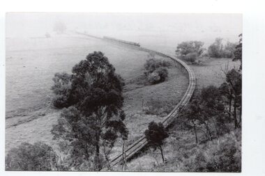
black and white photographs, Jude, Ray, 1915 - 1969
... in 1987. The station was located on the west side of the Snowy... in 1987. The station was located on the west side of the Snowy ...These photographs relate to the East Gippsland Railway. The Bairnsdale-Orbost railway was opened in 1916 to serve the agricultural and timber industry. Because of the decline in traffic and heavy operating costs, the line was finally closed in August, 1987. Orbost Railway Station was opened on Monday 10 April 1916 as the terminus of the Orbost railway line, and closed in 1987. The station was located on the west side of the Snowy River despite the town of Orbost being on the east side of the river, in order to save on the costs of a bridge over the river, which at the time had highly variable levels. These photographs are associated with the history of the Orbost-Bairnsdale railway line and therefore reflects the role that the rail line played in the social and economic history of Orbost.Seven black / white photographs and one postcard print.3103.1 on back - " Orbost- Snowy River flats viaduct 22-2-1964 ARHS special train Ray Jude photo" 3103.2 - on back -" Orbost Snowy River flats viaduct A.R.H.S. special train 22.2.1969" 3103.3 - on back - " A.R.H.S. special across bridge between Waygara & Nowa Nowa 22-2-1964 3103.4 - on back - " Nowa Nowa Boggy Creek Bridge A.R.H.s. Orbost tour Ray Jude photo" 3103.5 - on back - " Orbost 22-2-1969 SM office & goods shed Ray Jude photo" 3103.6 - on back - " Orbost Railway Yards - 22 February 19369 Ray Jude photo" 3103.7 - on back - " Orbost May 27 -1936 Orbost Rail Station" 3103.8 - on front - caption - Unloading Ballast Orbost line near Newmerella 1915 - J. Sullivan Colin ?orbost-railway east-gippsland-railway bairnsdale-orbost-railway -
 Orbost & District Historical Society
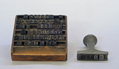
stamp holder and numbers, Victorian Government Railways, c. 1930s- 1980s
... in 1987. The station was located on the west side of the Snowy... in 1987. The station was located on the west side of the Snowy ...Used on the Orbost-Bairnsdale railway line which closed in 1987. The Bairnsdale-Orbost railway was opened in 1916 to serve the agricultural and timber industry. Because of the decline in traffic and heavy operating costs, the line was finally closed in August, 1987. Orbost Railway Station was opened on Monday 10 April 1916 as the terminus of the Orbost railway line, and closed in 1987. The station was located on the west side of the Snowy River despite the town of Orbost being on the east side of the river, in order to save on the costs of a bridge over the river, which at the time had highly variable levels This item is associated with the history of the Orbost-Bairnsdale railway line and therefore reflects the role that the rail line played in the social and economic history of Orbost.A stamp holder made of aluminium into which numbers and possibly letters can be inserted. Also a square shallow wooden box containing numbers which are used with the stamp. The numbers appear to be made of rubber.possibly V G R railway-history orbost-bairnsdale-railway -
 Orbost & District Historical Society
Victorian Railways pencil, Victorian Railways, c. 1960s-1980s
... , and closed in 1987. The station was located on the west side..., and closed in 1987. The station was located on the west side ...Used by Victorian Railways at stations on the Orbost-Bairnsdale line. The Bairnsdale-Orbost railway was opened in 1916 to serve the agricultural and timber industry. Because of the decline in traffic and heavy operating costs, the line was finally closed in August, 1987. Orbost Railway Station was opened on Monday 10 April 1916 as the terminus of the Orbost railway line, and closed in 1987. The station was located on the west side of the Snowy River despite the town of Orbost being on the east side of the river, in order to save on the costs of a bridge over the river, which at the time had highly variable levels. This item is associated with the history of the Orbost-Bairnsdale railway line and therefore reflects the role that the rail line played in the social and economic history of Orbost.A thick, hexagonal shaped pencil made of wood, painted dark blue, containing blue graphite marker.VICTORIA RAILWAYS written in gold lettering Emperor, Made in Australia railway-history victorian-railways orbost-bairnsdale-railway -
 Orbost & District Historical Society
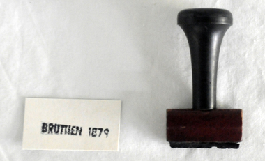
stamp, C 1960's
... in 1987. The station was located on the west side of the Snowy... in 1987. The station was located on the west side of the Snowy ...This stamp was used at the Orbost Railway Station. The Bairnsdale-Orbost railway was opened in 1916 to serve the agricultural and timber industry. Because of the decline in traffic and heavy operating costs, the line was finally closed in August, 1987. Orbost Railway Station was opened on Monday 10 April 1916 as the terminus of the Orbost railway line, and closed in 1987. The station was located on the west side of the Snowy River despite the town of Orbost being on the east side of the river, in order to save on the costs of a bridge over the river, which at the time had highly variable levels This item is associated with the history of the Orbost-Bairnsdale railway line and therefore reflects the role that the rail line played in the social and economic history of Orbost.A stamp with a black plastic handle. The bottom is wood and the stamp rubber. It has "BRUTHEN 1879" on it."BRUTHEN 1879"orbost-railway-station -
 Orbost & District Historical Society
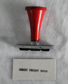
stamp, 1970's
... . The station was located on the west side of the Snowy River despite.... The station was located on the west side of the Snowy River despite ...This stamp was used at the Orbost Railway Station. The Bairnsdale-Orbost railway was opened in 1916 to serve the agricultural and timber industry. Because of the decline in traffic and heavy operating costs, the line was finally closed in August, 1987. Orbost Railway Station was opened on Monday 10 April 1916 as the terminus of the Orbost railway line, and closed in 1987. The station was located on the west side of the Snowy River despite the town of Orbost being on the east side of the river, in order to save on the costs of a bridge over the river, which at the time had highly variable levels, This item is associated with the history of the Orbost-Bairnsdale railway line and therefore reflects the role that the rail line played in the social and economic history of Orbost.A stamp with a red plastic handle and a white stamping face - "ORBOST FREIGHT DEPOT".VUESTAMP AUSTRALIAorbost-railway -
 Bendigo Historical Society Inc.
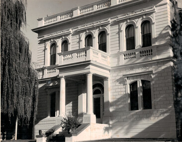
Document - Bendigo Home and Hospital for the Aged, 1860-1970s
... on the west side of Commissioner's Gully, Barnard Street, Bendigo... March 1860. The asylum is situated on the west side ...The inaugruration of the newly erected Benevolant Asylum took place on 15th March 1860. The asylum is situated on the west side of Commissioner's Gully, Barnard Street, Bendigo. The building itself is the design of Mr Robert A. Love, Architect, the Contractor is Mr Crawford and the Clerk of Works, Mr Wrigley. - from the Bendigo Advertiser 16th March 1860. In the Advertiser Dec 20 1872: the Memorial Stone was added and the design for the front elecvation was carried out as origionally planned with 12 columns of brick and cement each 36 feet high, the bases of which are granite. Typed History of the hospital, and letters regarding classification status and two A4 sized photos of the front of the building.history, national trust bendigo collection, bendigo, benevolant home bendigo, benevolant asylum bendigo, home and hospital for the aged bendigo, ann caudle centre bendigo -
 Kew Historical Society Inc
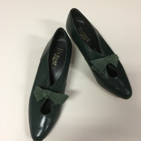
Footwear - Pair of Green Leather Court Shoes, Footwear Australia, 1980s
... manufactured in High Street Preston, on the west side not far up from... manufactured in High Street Preston, on the west side not far up from ...The extensive fashion and design collection of the Kew Historical Society has been assembled over a number of decades. One subsection of this collection is shoes, designed and manufactured for Australian women by Australian and European designers. Many of the shoes, while often mass-produced, were generally constructed by skilled artisans using traditional shoe-making techniques. The shoes date from the 1890s to the 1980s. Footrest Shoes were manufactured in High Street Preston, on the west side not far up from Dundas Street, but well before Bell St. Preston is a suburb of Melbourne.Pair of dark green leather women’s court shoes with a green fabric bow at the front, manufactured by Footrest, Australia.Footrest, Australia. Made by Footrest /Leather Uppers Linings & Soleswomen's shoes, footrest shoes, footwear, ladies footwear -
 Kew Historical Society Inc
Photograph, Outer Circle Railway Bridge over River Yarra, c.1900
... . The bridge has a cantilevered walkway along the west side... a cantilevered walkway along the west side. ...The Chandler Highway ...This photograph forms part of the Eric Sibly collection of images and information relating to the Outer Circle Railway which he donated to the Kew Historical Society in 1974. Heritage Victoria Citation (Abridged) "The Chandler Highway Bridge, a 137 metre wrought iron lattice-truss girder bridge with four spans supported on red brick piers with moulded bluestone cappings. The bridge has a cantilevered walkway along the west side. ...The Chandler Highway Bridge crosses the Yarra River and connects Alphington and Kew. It was completed in November 1890 as part of the Outer Circle Railway Line.Black & white photograph of the railway viaduct over Yarra River looking south towards Kew.Reverse: "Pre 1930. Outer Circle Railway Bridge over River Yarra (now Chandler Highway) - note bridge over line on Kew side for Asylum Farm". KH - 56. Kew Historical Society.chandler highway, railway bridges - kew (vic), sir john monash, outer circle railway, river yarra - kew (vic) -
 Kilmore Historical Society
Photograph, 5 Sydney Street, 2001
... Communications, former Kilmore Free Press Office. West side Sydney St... Kilmore Free Press Office. West side Sydney St, Kilmore, Opposite ...Connected with items: PHO-00010, PHO-00011 and PHO-00012.15cm x 10cm colour photograph of the cottage at the rear of Kilmore Communications, 5 Sydney Street. Printed on glossy photograph stock Konica brand. 2 photos included offering differing views of the property.Written on the back: Photo 1: Cottage at rear Former Kilmore Free Press Office 2001 5 Sydney St Photo: Heather Knight Photo 2: 5 Sydney St Cottage at rear shop - Kilmore Communications, former Kilmore Free Press Office. West side Sydney St, Kilmore, Opposite Husdon Park 2001 Photo: Heather Knight.real estate agents, cottages -
 Orbost & District Historical Society
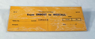
railways envelope, Victorian Railways, c. 1970s-1980s
... on the west side of the Snowy River despite the town of Orbost being.... The station was located on the west side of the Snowy River despite ...Used at Orbost railway station for the consignment of goods/freight, in this case, timber to Westall. The Bairnsdale-Orbost railway was opened in 1916 to serve the agricultural and timber industry. Because of the decline in traffic and heavy operating costs, the line was finally closed in August, 1987. Orbost Railway Station was opened on Monday 10 April 1916 as the terminus of the Orbost railway line, and closed in 1987. The station was located on the west side of the Snowy River despite the town of Orbost being on the east side of the river, in order to save on the costs of a bridge over the river, which at the time had highly variable levels. This item is associated with the history of the Orbost-Bairnsdale railway line and therefore reflects the role that the rail line played in the social and economic history of Orbost.An unused brown/buff coloured goods/freight consignment envelope used by Victorian Railways, this one for timber from Orbost to Westall. 2498-78 VICTORIAN RAILWAYS From ORBOST to WESTALL Contents TIMBER railway-history orbost-bairnsdale-railway -
 Orbost & District Historical Society
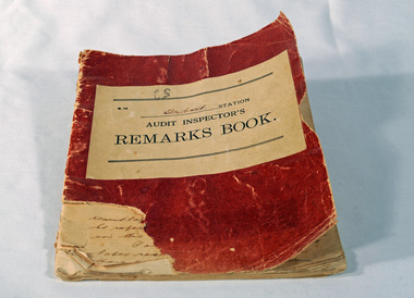
Victorian Railways remarks book, Victorian Railways, c. 1940s
... on the west side of the Snowy River despite the town of Orbost being... on the west side of the Snowy River despite the town of Orbost being ...Used at Orbost Railway Station, possibly by the Station Master, between 1944 and 1984. The Bairnsdale-Orbost railway was opened in 1916 to serve the agricultural and timber industry. Because of the decline in traffic and heavy operating costs, the line was finally closed in August, 1987. Orbost Railway Station was opened on Monday 10 April 1916 as the terminus of the Orbost railway line, and closed in 1987. The station was located on the west side of the Snowy River despite the town of Orbost being on the east side of the river, in order to save on the costs of a bridge over the river, which at the time had highly variable levels. This item is associated with the history of the Orbost-Bairnsdale railway line and therefore reflects the role that the rail line played in the social and economic history of Orbost.Book with a red cover. On the front cover VICTORIAN RAILWAYS Audit Inspectors Remarks Book, Orbost. Inside are numbered and lined pages with hand written information dating from 28/3/1944-13/8/1984, dated and signed by various station masters. Cover has a section missing from the bottom left.VICTORIAN RAILWAYS Audit Inspectors Remarks Book, Orbost.railway-history orbost-bairnsdale-railway -
 Orbost & District Historical Society
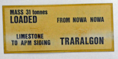
label / sign, 1970's -1980's
... . The station was located on the west side of the Snowy River despite.... The station was located on the west side of the Snowy River despite ...This item was used by Victorian Railways in 1980's. It was inserted onto the side of railway freight wagons. The Bairnsdale-Orbost railway was opened in 1916 to serve the agricultural and timber industry. Because of the decline in traffic and heavy operating costs, the line was finally closed in August, 1987. Orbost Railway Station was opened on Monday 10 April 1916 as the terminus of the Orbost railway line, and closed in 1987. The station was located on the west side of the Snowy River despite the town of Orbost being on the east side of the river, in order to save on the costs of a bridge over the river, which at the time had highly variable levels This item is associated with the history of the Orbost-Bairnsdale railway line and therefore reflects the role that the rail line played in the social and economic history of Orbost.A double -sided rectangular shaped label / sign, heavily laminated.Black print on light brown background. On one side : "MASS 31 tonnes LOADED; FROM NOWA NOWA; LIMESTONE TO APM SIDING; TRARALGON". On reverse : "EMPTY FROM TRARALGON; TO APM LIMESTONE SIDING ; NOWA NOWA".freight orbost-bairnsdale-railway -
 Stawell Historical Society Inc
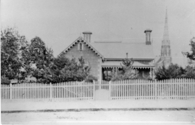
Photograph, Anglican Vicarage in Main Street Stawell
... the house on the west side of the Church was purchased... the house on the west side of the Church was purchased ...Brick Anglican Vicarage in Main Street purchased 1923 surrounded by trees and with picket fence and gate. In 1923 the house on the west side of the Church was purchased to be the Vicarage, the former Vicarage in Stawell West being sold. In this same year electricity was connected to the Church, the Hall and the Vicarage. The organ which had been hand pumped till then was fitted with and electric blower. This photo is a copy off a loaned postcard. The dwelling was purchased by the Anglican Church 1923, the former vicarage in Seaby Street being sold. The Spire in the background is St. Matthews Presbyterian Church. The vicarage is now demolished and replaced by a new building.Black & White photograph of a scene depicting a brick dwelling with veranda right hand side and a church spire in the background. Trees surrounding the building. A picket fence with gate and footpath in foreground.stawell religion church -
 Ballarat Tramway Museum
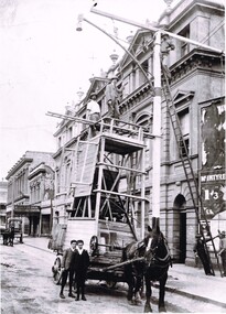
Photograph - Positioning street lights - Lydiard St North, Ballarat late 1890s
... between Mair St and the railway station on the west side... on the west side of Lydiard St North remain in position. Yields ...Photo of the installation of an electric arc type street lamp in Lydiard St North, near the Provincial Hotel Ballarat. The tower wagon is drawn by a single horse. Two boys standing alongside while two men are on the top of the wagon, a man on the top of the ladder is positioning a lifting beam while two men on the ground hold the rope for this beam. On the side of the wagon is possibly an extension that could be lifted onto the top of the tower itself to give a greater working height. The buildings between Mair St and the railway station on the west side of Lydiard St North remain in position. Yields information about the methodology of the late 1890's to install street lighting in BallaratDigital print of a Positioning street lights Lydiard St North Ballarat late 1890sarc lamps, ballarat, lydiard st north, electric lighting, tower wagons, horses, workmen, street lights -
 Melbourne Tram Museum
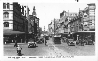
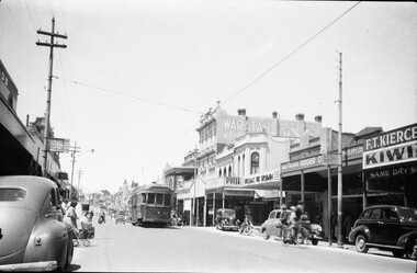
Postcard, Rose Stereograph Co, "Elizabeth Street from Lonsdale Street Melbourne", c1934
... store, one horse-drawn cart, and motor vehicles. On the west... store, one horse-drawn cart, and motor vehicles. On the west ...Rose Series postcard No. P 1701 titled "Elizabeth Street from Lonsdale Street Melbourne". Has a number of cable trams in the view, the closest one being a Brunswick tram. There is a policeman on point duty. In the view are signs for G A Grano Mantle manufacturers, Smiths Pawnbroker, State Savings Bank, MIchaels Camera store, one horse-drawn cart, and motor vehicles. On the west side footpath under an awning is a "Keep to the left" for pedestrians. Flinders St Railway Station can be seen in the far distance. The Brunswick cable tram line was closed Sept. 1935.Yields information about Elizabeth St, c1930Postcard - printed real photograph with Rose Stereograph Co. name on the rear.On rear in pencil "KM-M-076" and a Ken Magor stamp.trams, tramways, flinders st station, cable trams, elizabeth st -
 Ballarat Tramway Museum
Photograph - Black & White Photograph/s, Negative, Ellis Collection, c1950
... Black and white photograph of a bogie tram 22 west bound... stores on the west side of the street. c1950. Note the road ...Yields information about the appearance of Bridge St and the use of the trams c1950.Black and white photograph of a bogie tram 22 west bound in Bridge St. Has a group of ladies on either side of the road waiting to board? Note the signs on the poles on either side of the roadway. Has the Waratah Motors, Roger David stores on the west side of the street. c1950. Note the road lifting over the Yarrowee River bridge. The two signs on either side of the road "No Parking over 1 hour Park 1 Foot from kerb" Negative number 1140. Negative scanned at 2400dpi. On the top edge of one of the prints "same as 1094"trams, tramways, ballarat, bridge st, signs, tram 22 -
 Ballarat Tramway Museum
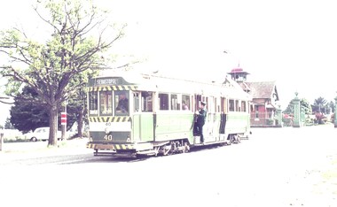
Slide - 35mm slide/s - set of 2, Robert Thomson, 27-4-1965?
... on the west side of the road. The conductor is boarding and the driver... on the west side of the road. The conductor is boarding and the driver ...Yields information about tram 40, the Lydiard St terminus tram stop and the Sebastopol tram terminus and tram 40.Agfa blue/white mount, colour slide of tram 40 at both the Lydiard St North and Sebastopol terminus. Both over exposed photos. .1 - No. 40 early in the morning given the sun position, shows the cemetery gates and the tram stop sign on the west side of the road. The conductor is boarding and the driver is in the cabin. Tram has the destination of Sebastopol. .2 - has the tram side on, with the Royal Mail Hotel in the background. Slide not dated, but based on slide mount and views and Reg item 7483, likely to be 27-4-1965tramways, trams, lydiard st north, sebastopol, tram stops, tram 40 -
 Ballarat Tramway Museum
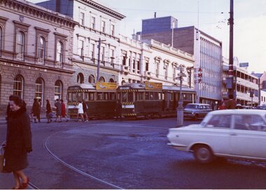
Photograph - Colour Photograph/s, Travis Jeffrey, 21/08/1971 12:00:00 AM
... along the west side of Lydiard St. Nth. Also a number... buildings and other buildings along the west side of Lydiard St. Nth ...Colour photograph of Ballarat No. 43 and 37 in Lydiard St. North, at the intersection with Sturt St. No. 43 northbound, No. 37 about to turn into Sturt St (north side - See Reg. Item 2421). Both trams have the SEC roof advertisement "Everything's under control in my all electric kitchen". In the background is the ANZ bank, the AMP buildings and other buildings along the west side of Lydiard St. Nth. Also a number of pedestrians in the photograph. Photo on Agfa Paper and taken on Friday 21 August 1971.Stamps with faded green ink: "Photo by Chris Jeffrey / Number" with number "104PC/14" in blue ink and date stamp "Friday 21 August 1971" also in faded green ink.lydiard st nth, sturt st, anz, amp, tram 43, tram 37 -
 Melbourne Tram Museum
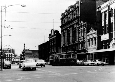
Photograph - Black & White Photograph/s, 1960's
... west side of the Latrobe St intersection. Has an ANZ bank... around it. Photo taken from the south west side of the Latrobe St ...Black and white photograph of trams W2 229, south bound in Swanston St, passing the now RMIT buildings. Has the Carlton United, Victoria Bitter buildings in the background. Tram has the destination of Malvern Darling Road, Route 4D. Photo taken early 1960's? given the cars around it. Photo taken from the south west side of the Latrobe St intersection. Has an ANZ bank and Storey hall in the background. Printed on Fujichrome paper. Not known who took the photograph or when it was printed.Stamped in black ink on back "TMSV Sales"trams, tramways, swanston st, rmit, latrobe st, darling rd, tram 229 -
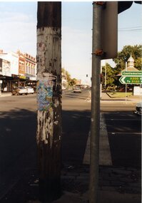 Ballarat Tramway Museum
Photograph - Colour Photograph/s, Austin Brehaut, Mar. 1999
... , cnr Howard St. (west side) .15 - Lydiard St. Nth, cnr Gregory..., cnr Howard St. (west side) .15 - Lydiard St. Nth, cnr Gregory ...Set of 23 photographs taken by Austin Brehaut during March and April 1999 of power poles along the former tram routes that still have signs of the former tram stops. An accompanying note (scanned) written by Austin Brehaut is reproduced below in Other Information - see related documents. 1096.1 - Sturt St at Doveton St., south (down) side. .2 - Drummond St. Sth (east side) outside St. Patrick's School between Dana and Eyre St. .3 - Drummond St. Sth, cnr Urquhart St. (east side) .4 - Drummond St. Sth, cnr South St. (east side) .5 - Drummond St. Sth, cnr Sebastopol St. (east side) .6 - Drummond St. Sth, cnr Latrobe St. (east side) .7 - Drummond St. Sth, cnr Darling St. .8 - Sturt St. cnr Ripon St. (North East side) .9 - Ripon St. Nth, cnr Sussex St. .10 - Ripon St. Nth, cnr Mair St. (South West Corner) .11 - Ripon St. Nth, cnr Mair St. (North East Corner) .12 - Macarthur St. cnr Burbank St. (up side) .13 - Lydiard St. Nth, cnr Clarendon St. (east side) .14 - Lydiard St. Nth, cnr Howard St. (west side) .15 - Lydiard St. Nth, cnr Gregory St. (west side) .16 - Lydiard St. Nth, cnr Howitt St. (west side) .17 - Lydiard St. Nth, near Walker St., (east side) .18 - Lydiard St. Nth, cnr Landsborough St. (east side) .19 - Barkly St. cnr Main Road (up side) .20 - Barkly St. near Haymes Cres (down side) .21 - Barkly St., near Young St. (down side) .22 - Barkly St, Cameron St (up side) .23 - Barkly St., at Cobden St. terminus (west side) .1 - April 99, .2 > .10, 9/3/99, .11 > .18 - March 1999, .19 > .23 - April 1999. See also Reg. Item 768.1 > 768.6 for another group of tram stop photos in Drummond St. in 1997. On Fujifilm paper.On rear of each photo in blue ink is location at date at the top of the photo and in the bottom right hand corner - initials "APB"tram stops, power poles, barkly st., lydiard st. nth, ripon st., sturt st., drummond st. sth