Showing 3398 items matching " power"
-
 Eltham District Historical Society Inc
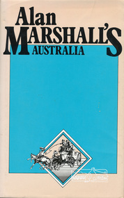
Book, Hyland House, Alan Marshall's Australia, 1981
One of a collection of books by local writer Alan Marshall held at EDHS. This one is of "anecdotes and yarns" as described by Marshall before its publication in July 1981 in the Canberra Times. Alan Marshall's Australia, the Australia of "I Can Jump Puddles" has vanished. No longer do we have time to sit on the sliprail and exchange yarns, to drive buggies down long, quiet dusty roads, or to watch the king-hit merchant operating in some small hotel. Even the Cu-nims hold no terrors for a Boeing 427! And yet - Alan Marshall's Australia lives for all those who read this book. Meet Lance Skuthorpe who tethered an old bull in Bourke Street and offered £5 to anyone who could ride it for half a minute and Binjarrpooma, the Arnhem Land terror. Accompany Alan in his horse-drawn caravan or buggy to country sales, pubs and stations and listen with him to great bush eccentrics, lairs and yarn spinners. Go further back and remember Conversation Lollies, the cigarette cards you collected and the school yard games. Can you recall how to test an axe blade, choose a pocket knife, or the penetrating power of Goanna Oil? But this book is more than a nostalgic journey into the past ; it is history for the young and a timely reminder for us all - it is our roots. - Front end papers viii, 165 p. : ill. ; Two copiesISBN 0908090390alan marshall, prose, short stories, ancedotes, australia, tales, yarms -
 Flagstaff Hill Maritime Museum and Village
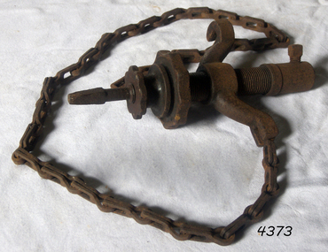
Tool - Chain Drill Attachment, Millers Falls Co, 1900-1931
An auxiliary tool for use with a breast drill or bit brace, when extra power is needed, or where pressure cannot be easily applied. The drill is automatically fed into the work by an adjustable friction feed which is automatically regulated by the resistance the drill encounters. These were made to fit on breast drills, and used for drilling metal, particularly round sections like a pipe. The chain is run around the object being drilled and gradually tightens as the hole is drilled, maintaining pressure while being a bit easier on the operator. Millers Falls Co. is a tool manufacturing company originally based in Millers Falls, Massachusetts, USA. It was established in Greenfield, Massachusetts in 1868 as Gunn & Amidon by Levi J. Gunn and Charles H. Amidon. Gunn and Amidon, along with a third partner, Henry L. Pratt built a factory in the north of Greenfield. After the Greenfield factory burned down, the company was reorganized as the Millers Falls Manufacturing Co. It merged with Backus Vise Co. in 1872 to form Millers Falls Co. In 1931 Millers Falls tools purchased the majority of the shares of Goodell-Pratt tools and merged with that manufacturer in 1932. In 1962 the company was acquired by Ingersoll Rand. In 1982, Ingersoll Rand sold the Millers Falls business to the newly created Millers Falls Tool Co. The company was head quartered in Alpha, New Jersey. Since 2002 the company trademark has belonged to Hangzhou Great Star Industrial, of Hangzhou, China. The item is associated with a tool manufacturing company established in the mid-19th century that pioneered the development of many types of tools used in many differing trades. The company grew to become a major supplier of tools around the world and today its tools that were produced during the mid-19th and early 20th centuries are now collectable items. Drill attachment with chain No 717 from 1925 catalogue 1/2 socket hole Millers Falls, Massachusettsflagstaff hill, warrnambool, flagstaff hill maritime museum, maritime museum, shipwreck coast, flagstaff hill maritime village, great ocean road, chain drill, mast drill, millers falls, drilling attachment, drilling tools -
 Federation University Historical Collection
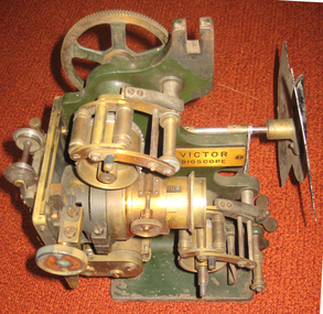
Equipment - Projector, Victor Bioscope, c1910
A Bioscope show was a fairground attraction consisting of a travelling cinema. The heyday of the Bioscope was from the late 1890s until World War I. Bioscope shows were fronted by the largest fairground organs, and these formed the entire public face of the show . A stage was usually in front of the organ, and dancing girls would entertain the crowds between film shows. Films shown in the Bioscope were primitive, and the earliest of these were made by the showmen themselves. Later, films were commercially produced. Bioscope shows were integrated, in Britain at least, into the Variety shows in the huge Music Halls which were built at the end of the nineteenth century. After the Music Hall Strike of 1907 in London, bioscope operators set up a trade union to represent them. There were about seventy operators in London at this point. (http://en.wikipedia.org/wiki/Bioscope_show) The Projector was a rather unreliable piece of apparatus, powered by a variety of light sources, including Calcium Oxide (Lime-Light). A Calcium Carbide Burner, or the rather more superior Carbon Arc. All these methods were highly unpredictable & quite frankly...dangerous! Often resulting in explosions, burning down the entire Show! (which is probably why NO original Shows still exist. Alfred Ball's Bioscope, pictured below, built in 1905 was struck by lightning, shortly after the picture was taken! (http://www.circus-entertainer.co.uk/heritage.htm) In 1909 the first bioscopes pictures were shown at the Ballaarat Mechanics' Institute.Brass and green painted metal film projectorbioscope, vector, entertainment, projector, film, theatre, movie -
 Flagstaff Hill Maritime Museum and Village
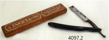
Functional object - Razor and case, E.M. Dickinson, 1895-1930
E M Dickinson was a cutlery company in Sheffield that made all types of cutlery knives of all types and patterns, razors domestic electroplated cutlery etc. Edwin Murray Dickinson started recruiting workers for his new cutlery firm at 11 Cambridge Street Sheffield England in 1870. The original premises consisting of warehouse, offices, cutlers shops fitted with the latest steam-powered equipment however this premises was offered for let in November 1887, and new premises were secured at 51 Division Street and were occupied by Dickinson's in early 1888. By October 1890 Dickinson was advertising the Division Street premises to let and moved the company into other new works (still called Murray Works) at 122 Rockingham Street. On 12th October 1901, Dickinson gave notice that the firm was to be converted to a limited company and by March 1908 the Rockingham Street works had been advertised for sale. In 1909 the deeds for other new premises at 203 Arundel Street Sheffield were deposited to secure a £3,000 loan from the Sheffield Banking Company. Then on Christmas Eve 1926 several hundred pounds worth of damage was caused by a fire at the Arundel Street works. The founder, Edwin Dickinson died on 21st October 1930 aged 81 at his home at 449 Crookesmoor Road and on the 23rd May 1939 the firm went into voluntary liquidation.An item made by a company that made many different types and patterns of cutlery for domestic use and export.Straight razor with black celluloid handle and it’s boxBlade has marking, INVICTA" with decorative engraved design, on the other side engraved "E M DICKINSON SHEFFIELD ENGLAND"flagstaff hill, warrnambool, flagstaff-hill, flagstaff-hill-maritime-museum, shipwreck-coast, flagstaff-hill-maritime-village, razor, e m dickinson ltd, e m dickinson ltd sheffield england., cut throat razor, cutlery -
 Flagstaff Hill Maritime Museum and Village
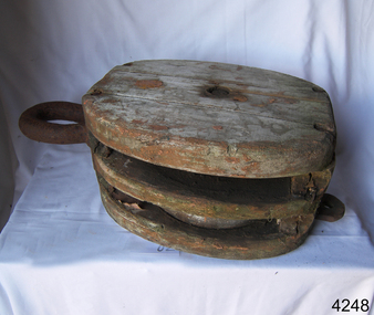
Equipment - Block, Late 19th to early 20th century
A sailing block is single or multiple pulleys with one or more sheaves that are enclosed in an assembly between cheeks or chocks. In use, a block is fixed to the end of a line, to a spar, or a surface. A rope line is reeved through the sheaves, and maybe through one or more matching blocks at the far end, to make up what's known as a tackle. The purchase of a tackle refers to its mechanical advantage. In general, the more sheaves in the blocks that make up a tackle, the higher its mechanical advantage. The matter is slightly complicated by the fact that every tackle has a working end where the final run of rope leaves the last sheave. More mechanical advantage can be obtained if this end is attached to the moving load rather than the fixed end of the tackle. Various types of blocks are used in sailing. Some blocks are used to increase mechanical advantage and others are used simply to change the direction of a line. A ratchet block turns freely when a line is pulled in one direction but does not turn in the other direction, although the line may slip past the sheave. This kind of block makes a loaded line easier to hold by hand and is sometimes used on smaller boats for lines like main and jib sheets that are frequently adjusted. A single, large, sail-powered warship in the mid-19th century required more than 1,400 blocks of various kinds and sizes.A historic item from an old sailing vessel from the late 19th to early 20th century, unfortunately. It represents part of the rigging required to set the sails on a wind-powered vessel.A two sheave wood sailing block with metal hook and becket. One sheave missing. flagstaff hill, warrnambool, shipwrecked-coast, flagstaff-hill, flagstaff-hill-maritime-museum, maritime-museum, shipwreck-coast, flagstaff-hill-maritime-village, block, sailing block, two-sheave block, 2 sheave wood block, marine technology, sailing equipment, rigging, rigging block -
 Flagstaff Hill Maritime Museum and Village
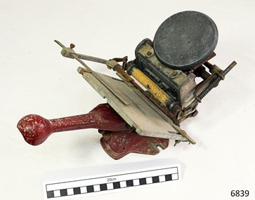
Printing Press, C. 1934
This small Adana letterpress was based on a larger press. It was intended for printing stationery such as business cards, visitor’s cards, shop price cards and notepaper headers, Used for letterpress printing, and advertised as “Virtually indestructible”. Used for hobby printing, schools, and similar uses. When donated to Flagstaff Hill the chase still had letter type in it, which was printed out "THE SHADOWS / apahc / the aauage / shaboogie ". Currently, the machine is used by the Flagstaff Hill "Examiner" office to make business cards for use by some of the Volunteers in the Village. HISTORY Donald Aspinall, born in London in 1899, suffered shell shock while serving in World War 1. During his recovery, while still a teenager, he worked his hobby, the design of a small flatbed printing press, then advertised it in The Model Engineer’ in 1918 and received an overwhelming response of orders. In 1922 Aspinall founded the Adana Agency, in Twickenham. His had great success in his sales of flatbed, self-inking wooden presses to hobby printing enthusiasts. Over the years Adana made a variety of machines; flatbed, lever, treadle and powered presses Adana cast its own type in 1925 and has a number of patents for press parts. In the 1980’s the company wound down, and was purchased by Caslon, who still service and supply part for the Adana machines. Printing press; hand operated small letterpress machine made by Adana. Tiny platen style. Model Five-Three (5 inch x 3 inch). Cast metal base and lever handle with rounded end, both painted dark red, rounded red metal lever handle. C. 1934 Marks on foot of stand " REG. NO. / ISIL 46 & S00575 / PATENTS PENDING" and "REG. TRADE MARK / ADANA"flagstaff hill, warrnambool, shipwrecked coast, flagstaff hill maritime museum, maritime museum, shipwreck coast, flagstaff hill maritime village, great ocean road, adana letterpress, adana model three-five, mini letterpress, printing machine, donald aspinall -
 Australian Commando Association - Victoria
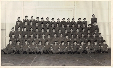
Photograph, Unknown, 2 COMMANDO COMPANY Ripponlea pay parade July 1958, 1958
Unit members in the photo: Back row: Peter Herd, Mick Stewart, Ian Bunston, Russ Bradley, Bob West, Peter Reid, Norm 'Doc' Willoughby, Brian Hinneburg, Claude Gillard, _______ , Kevin Hatfield, Ian Hicks, Mack Hinds, John Woodruff. 4th row: Geoff Smith, Phil 'Juni0r' Meakins, Phillip Roff, George Wing, 'Bluey' De Clerk, Bob 'Canada' Johnston, Jim Walsh, Mike Hicks, Ern Jeffries, Carl 'Dutchy' Hulsbergen, Leigh Power, __________ , Norm 'Mick' Kennedy, Ray Bunyard, Jack Murray. 3rd row: Jeff Tomlinson, ______ , Vince Nehill, Jim Stephens, Bert Boatwright, Bill Leach, Bob Reid, Peter 'Padre' Bowden, ______ , Frank Read, Peter Higgins, Bill Salmon, John Hutchinson, Gus Kongas, Tony Poole. 2nd row: Roman Stuczynski, Stan Polan, Allan Moore, Don Bergman, Col 'Ali' Barbour, Peter Askew, Ron Smith, OC Major John Hutcheson, Adj Capt John Pritchard, Lt John O'Rourke, Ron Scott, George 'Taffy' Drakopoulos, Ted Malone, Ray Sanders, Kevin Collins, Barry Creighton. 1st row: Tom Massey, Mick Thurlough, Glen Watterson, Joe Frazer, Warren Hutchings, Max Coulson, Graham Gould?, Maurice 'Elvis' Priestly, _______ , 'Bluey' Darlington, 'Bluey' _____ , _____________ , 'Tich' McIntyre, Jim Trainor. Proovided by Jim Trainor.One of a very few photos only of (almost) the complete personnel of 2 Cdo Coy in its early years. B & W group photo unframed, 5 rows tiered, 73 men in winter battledress at the 2 Commando Company depot at Ripponlea, Melbourne in 1958. A separate document names most of the men. Described by Jim Trainor as Ripponlea pay parade July 1958. 2 commando company - 1958 - pay parade - ripponlea depot - unit personnel -
 Flagstaff Hill Maritime Museum and Village
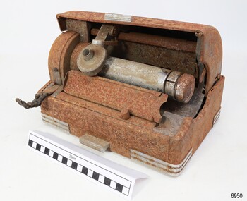
Machine - Voice Recorder, Thomas A. Edison, Edison Laboratory, 1916-1929
This Edison Ediphone voice recording electronic business machine is manufactured to suit a small office and is light enough to carry between work and home for use outside normal business hours. It is a dictation machine, also called by the competitor’s brand name ‘Dictaphone’, and is used for recording spoken words that would later be transcribed and typewritten. A wax cylinder would be installed onto the machine’s drum and the Reproducer on the machine would be lowered onto the cylinder. The user would speak a message into a microphone and the reproducer would then convert the sounds to scribed marks on the cylinder. Later, the cylinder could be played and the Reproducer would enable the sound to be amplified through an attached speaker. This machine is currently without its power cord, microphone and speaker horn. Thomas A. Edison extended the technology of the telegraph to his phonograph machine, invented in the late 19th century. It could record and play back sounds of music and voice on a manually operated mechanical machine that used wax cylinders to store the sound. He envisaged the way this technology could be an asset in the office, and he was right! However, most of his phonograph machines were used for entertainment, some for playing lessons, and some for-teaching languages. In 1916 Edison introduced the Ediphone, which grew in popularity after the First World War and into the late 1920s until flat round records replaced the wax cylinders. This Edison Ediphone is significant for improving the way business administration was carried out in the early 20th century, freeing up precious time for professionals and administrative personnel. It was the forerunner of audio tapes and digital technology. The Ediphone enabled letters to be dictated when the time and place suited and reduced the time professionals needed to spend with their secretaries. Secretaries were able to type the letters as they played the recording and they could replay the message if necessary.Voice recorder; a dictation machine; desktop model Edison Ediphone. The electronic machine is in a medal case with remnants of the original grey colour. It has a rectangular base with an A4-sized footprint and a domed hood that retracts halfway into the back of the base. The corners of the base have metal reinforcing, and a short metal bar is on the front centre edge of the lid and the base. A long metal drum is mounted inside the machine. A round device called a ‘reproducer’ is mounted above the drum. There is a folding handle on the left front of the machine and an angled stand with paper guides in front of the drum. A rear cover has the maker’s name stamped on it. An electrical socket with eight pins is recessed beside the cover. Made by Edison.In white letters; “EDISON”flagstaff hill, warrnambool, maritime village, maritime museum, shipwreck coast, great ocean road, edison, ediphone, dictating machine, office equipment, voice recorder, usa, dictation, communication, office machine, dictaphone, speaking phonograph, thomas edison, ediphone voicewriter, voice writer -
 National Wool Museum
Machine - Axminster Carpet Loom, Brintons Ltd (UK), c. 1910
The Axminster Carpet Loom has been set up as a focal point in the centre of the National Wool Museum. The loom was originally built by Brintons in England around 1910 and was initially operating in Geelong in 1960. Brintons designed and built most of their own looms and ancillary equipment. When superseded in 1975 the loom was donated to the Melbourne College of Textiles for weaving training. The College has now donated the loom to the National Wool Museum and Brintons engineering staff has restored it to full working condition. This loom is known as an Axminster gripper loom. The gripper system was invented by Brintons in 1890 and operates using a gripper shaped like a birds beak. This grips the yarn, the yarn is then cut and the gripper swings down to place the tuft into the woven backing. This particular loom also uses a jacquard system for weaving colours. In jacquard weaving, punched cards are used to instruct the loom as to which colour to use. The system was invented by Joseph Jacquard, a silk weaver from Lyon, and was introduced in 1804. It revolutionised pattern weaving as it had the capacity to create intricate patterns through the use of the cards. By 1833 there were approximately 100,000 power-looms used in Great Britain that had been influenced by Jacquards invention. Joseph Jacquard died in 1834. Charles Babbage was later to adapt Jacquards punch-card system to produce a calculator that was the forerunner of todays methods of computer programmingAxminster carpet loom featuring over 1000 Jacquard punch cards and over 100 bobbins of different colours of wool.loom carpet wool, geelong woolbrokers' association, geelong, auction -
 Ballarat Heritage Services
Photograph - Colour, Earth Banks, Old Sarum, England, 2016, 01 November 2016
William the Conqueror inherited Old Sarum from the last Saxon king of England. It was an ideal site for a royal castle. It was here in 1070 that William paid off his army after a long and bitter campaign in northern England. It was here in 1086 that he called together all the major landholders in England so they could swear allegiance to him. It was a crucial moment. The Domesday Book was being written, a threatened Viking invasion had only just been averted and William's eldest son was in armed rebellion. Old Sarum was an important place where this Norman king of England held power. In 1794 the Ordnance Survey set out to check the accuracy of the first mapping of Southern England, which had begun ten years earlier. From a point just below Old Sarum Lieutenant William Mudge laid out a base-line 36,574 feet (11,253 metres) long. From each end of the line the positions of distant places were plotted using a huge theodolite made in 1791 by Jesse Ramsden. The accuracy of the process, which was repeated all over England, depended on Jesse Ramsden's craftsmanship and on William Mudge's surveying skill in setting out this first base-line from Old Sarum. The nearer end of Mudge's line is marked by an inscribed stone beside the modern A345 at Old Sarum. ordnance survey, william mudge, jesse ramsden, william the conqueror, old sarum, saxon, 1086, england -
 Ballarat Heritage Services
Photograph - Colour, Earth Banks, Old Sarum, England, 01 November 2016
William the Conqueror inherited Old Sarum from the last Saxon king of England. It was an ideal site for a royal castle. It was here in 1070 that William paid off his army after a long and bitter campaign in northern England. It was here in 1086 that he called together all the major landholders in England so they could swear allegiance to him. It was a crucial moment. The Domesday Book was being written, a threatened Viking invasion had only just been averted and William's eldest son was in armed rebellion. Old Sarum was an important place where this Norman king of England held power. In 1794 the Ordnance Survey set out to check the accuracy of the first mapping of Southern England, which had begun ten years earlier. From a point just below Old Sarum Lieutenant William Mudge laid out a base-line 36,574 feet (11,253 metres) long. From each end of the line the positions of distant places were plotted using a huge theodolite made in 1791 by Jesse Ramsden. The accuracy of the process, which was repeated all over England, depended on Jesse Ramsden's craftsmanship and on William Mudge's surveying skill in setting out this first base-line from Old Sarum. The nearer end of Mudge's line is marked by an inscribed stone beside the modern A345 at Old Sarum. ordnance survey, william mudge, jesse ramsden, william the conqueror, old sarum, saxon, 1086, england -
 Ballarat Heritage Services
Photograph - Colour, Stonework, Old Sarum, England, English Heritage Site, 01 November 2016
William the Conqueror inherited Old Sarum from the last Saxon king of England. It was an ideal site for a royal castle. It was here in 1070 that William paid off his army after a long and bitter campaign in northern England. It was here in 1086 that he called together all the major landholders in England so they could swear allegiance to him. It was a crucial moment. The Domesday Book was being written, a threatened Viking invasion had only just been averted and William's eldest son was in armed rebellion. Old Sarum was an important place where this Norman king of England held power. In 1794 the Ordnance Survey set out to check the accuracy of the first mapping of Southern England, which had begun ten years earlier. From a point just below Old Sarum Lieutenant William Mudge laid out a base-line 36,574 feet (11,253 metres) long. From each end of the line the positions of distant places were plotted using a huge theodolite made in 1791 by Jesse Ramsden. The accuracy of the process, which was repeated all over England, depended on Jesse Ramsden's craftsmanship and on William Mudge's surveying skill in setting out this first base-line from Old Sarum. The nearer end of Mudge's line is marked by an inscribed stone beside the modern A345 at Old Sarum. ordnance survey, william mudge, jesse ramsden, william the conqueror, old sarum, saxon, 1086, england -
 Ballarat Heritage Services
Photograph - Colour, Stonework, Old Sarum, England, English Heritage Site, 2016, 01 November 2016
William the Conqueror inherited Old Sarum from the last Saxon king of England. It was an ideal site for a royal castle. It was here in 1070 that William paid off his army after a long and bitter campaign in northern England. It was here in 1086 that he called together all the major landholders in England so they could swear allegiance to him. It was a crucial moment. The Domesday Book was being written, a threatened Viking invasion had only just been averted and William's eldest son was in armed rebellion. Old Sarum was an important place where this Norman king of England held power. In 1794 the Ordnance Survey set out to check the accuracy of the first mapping of Southern England, which had begun ten years earlier. From a point just below Old Sarum Lieutenant William Mudge laid out a base-line 36,574 feet (11,253 metres) long. From each end of the line the positions of distant places were plotted using a huge theodolite made in 1791 by Jesse Ramsden. The accuracy of the process, which was repeated all over England, depended on Jesse Ramsden's craftsmanship and on William Mudge's surveying skill in setting out this first base-line from Old Sarum. The nearer end of Mudge's line is marked by an inscribed stone beside the modern A345 at Old Sarum. ordnance survey, william mudge, jesse ramsden, william the conqueror, old sarum, saxon, 1086, england -
 Ballarat Heritage Services
Photograph - Colour, Stonework and well, Old Sarum, England, English Heritage Site, 2016, 01 November 2016
William the Conqueror inherited Old Sarum from the last Saxon king of England. It was an ideal site for a royal castle. It was here in 1070 that William paid off his army after a long and bitter campaign in northern England. It was here in 1086 that he called together all the major landholders in England so they could swear allegiance to him. It was a crucial moment. The Domesday Book was being written, a threatened Viking invasion had only just been averted and William's eldest son was in armed rebellion. Old Sarum was an important place where this Norman king of England held power. In 1794 the Ordnance Survey set out to check the accuracy of the first mapping of Southern England, which had begun ten years earlier. From a point just below Old Sarum Lieutenant William Mudge laid out a base-line 36,574 feet (11,253 metres) long. From each end of the line the positions of distant places were plotted using a huge theodolite made in 1791 by Jesse Ramsden. The accuracy of the process, which was repeated all over England, depended on Jesse Ramsden's craftsmanship and on William Mudge's surveying skill in setting out this first base-line from Old Sarum. The nearer end of Mudge's line is marked by an inscribed stone beside the modern A345 at Old Sarum. ordnance survey, william mudge, jesse ramsden, william the conqueror, old sarum, saxon, 1086, england -
 Ballarat Heritage Services
Photograph - Colour, Stonework, Old Sarum, England, English Heritage Site, 01 November 2016
William the Conqueror inherited Old Sarum from the last Saxon king of England. It was an ideal site for a royal castle. It was here in 1070 that William paid off his army after a long and bitter campaign in northern England. It was here in 1086 that he called together all the major landholders in England so they could swear allegiance to him. It was a crucial moment. The Domesday Book was being written, a threatened Viking invasion had only just been averted and William's eldest son was in armed rebellion. Old Sarum was an important place where this Norman king of England held power. In 1794 the Ordnance Survey set out to check the accuracy of the first mapping of Southern England, which had begun ten years earlier. From a point just below Old Sarum Lieutenant William Mudge laid out a base-line 36,574 feet (11,253 metres) long. From each end of the line the positions of distant places were plotted using a huge theodolite made in 1791 by Jesse Ramsden. The accuracy of the process, which was repeated all over England, depended on Jesse Ramsden's craftsmanship and on William Mudge's surveying skill in setting out this first base-line from Old Sarum. The nearer end of Mudge's line is marked by an inscribed stone beside the modern A345 at Old Sarum. ordnance survey, william mudge, jesse ramsden, william the conqueror, old sarum, saxon, 1086, england -
 Ballarat Heritage Services
Photograph - Colour, Sign Explaining toilets, Old Sarum, England, English Heritage Site, 01/11/2016
William the Conqueror inherited Old Sarum from the last Saxon king of England. It was an ideal site for a royal castle. It was here in 1070 that William paid off his army after a long and bitter campaign in northern England. It was here in 1086 that he called together all the major landholders in England so they could swear allegiance to him. It was a crucial moment. The Domesday Book was being written, a threatened Viking invasion had only just been averted and William's eldest son was in armed rebellion. Old Sarum was an important place where this Norman king of England held power. In 1794 the Ordnance Survey set out to check the accuracy of the first mapping of Southern England, which had begun ten years earlier. From a point just below Old Sarum Lieutenant William Mudge laid out a base-line 36,574 feet (11,253 metres) long. From each end of the line the positions of distant places were plotted using a huge theodolite made in 1791 by Jesse Ramsden. The accuracy of the process, which was repeated all over England, depended on Jesse Ramsden's craftsmanship and on William Mudge's surveying skill in setting out this first base-line from Old Sarum. The nearer end of Mudge's line is marked by an inscribed stone beside the modern A345 at Old Sarum. Colour photograph of a sign explaining toilets at Old Sarum, English Heritage Siteordnance survey, william mudge, jesse ramsden, william the conqueror, old sarum, saxon, 1086,, england -
 Ballarat Heritage Services
Photograph - Colour, Old Sarum, England, 2017, 01 November 2016
William the Conqueror inherited Old Sarum from the last Saxon king of England. It was an ideal site for a royal castle. It was here in 1070 that William paid off his army after a long and bitter campaign in northern England. It was here in 1086 that he called together all the major landholders in England so they could swear allegiance to him. It was a crucial moment. The Domesday Book was being written, a threatened Viking invasion had only just been averted and William's eldest son was in armed rebellion. Old Sarum was an important place where this Norman king of England held power. In 1794 the Ordnance Survey set out to check the accuracy of the first mapping of Southern England, which had begun ten years earlier. From a point just below Old Sarum Lieutenant William Mudge laid out a base-line 36,574 feet (11,253 metres) long. From each end of the line the positions of distant places were plotted using a huge theodolite made in 1791 by Jesse Ramsden. The accuracy of the process, which was repeated all over England, depended on Jesse Ramsden's craftsmanship and on William Mudge's surveying skill in setting out this first base-line from Old Sarum. The nearer end of Mudge's line is marked by an inscribed stone beside the modern A345 at Old Sarum. ordnance survey, william mudge, jesse ramsden, william the conqueror, old sarum, saxon, 1086, england -
 Ballarat Heritage Services
Photograph - Photograph - Colour, Old Sarum, England, 2016, 01/11/2016
William the Conqueror inherited Old Sarum from the last Saxon king of England. It was an ideal site for a royal castle. It was here in 1070 that William paid off his army after a long and bitter campaign in northern England. It was here in 1086 that he called together all the major landholders in England so they could swear allegiance to him. It was a crucial moment. The Domesday Book was being written, a threatened Viking invasion had only just been averted and William's eldest son was in armed rebellion. Old Sarum was an important place where this Norman king of England held power. In 1794 the Ordnance Survey set out to check the accuracy of the first mapping of Southern England, which had begun ten years earlier. From a point just below Old Sarum Lieutenant William Mudge laid out a base-line 36,574 feet (11,253 metres) long. From each end of the line the positions of distant places were plotted using a huge theodolite made in 1791 by Jesse Ramsden. The accuracy of the process, which was repeated all over England, depended on Jesse Ramsden's craftsmanship and on William Mudge's surveying skill in setting out this first base-line from Old Sarum. The nearer end of Mudge's line is marked by an inscribed stone beside the modern A345 at Old Sarum. Colour photograph of Old Sarum, England.ordnance survey, william mudge, jesse ramsden, william the conqueror, old sarum, saxon, 1086, england -
 Ballarat Heritage Services
Photograph - Colour, Earth Banks, Old Sarum, England, 01 November 2016
William the Conqueror inherited Old Sarum from the last Saxon king of England. It was an ideal site for a royal castle. It was here in 1070 that William paid off his army after a long and bitter campaign in northern England. It was here in 1086 that he called together all the major landholders in England so they could swear allegiance to him. It was a crucial moment. The Domesday Book was being written, a threatened Viking invasion had only just been averted and William's eldest son was in armed rebellion. Old Sarum was an important place where this Norman king of England held power. In 1794 the Ordnance Survey set out to check the accuracy of the first mapping of Southern England, which had begun ten years earlier. From a point just below Old Sarum Lieutenant William Mudge laid out a base-line 36,574 feet (11,253 metres) long. From each end of the line the positions of distant places were plotted using a huge theodolite made in 1791 by Jesse Ramsden. The accuracy of the process, which was repeated all over England, depended on Jesse Ramsden's craftsmanship and on William Mudge's surveying skill in setting out this first base-line from Old Sarum. The nearer end of Mudge's line is marked by an inscribed stone beside the modern A345 at Old Sarum. ordnance survey, william mudge, jesse ramsden, william the conqueror, old sarum, saxon, 1086, england -
 Ballarat Heritage Services
Photograph - Colour, Dorothy Wickham, Earth Banks, Old Sarum, England, 2016, 01 November 2016
William the Conqueror inherited Old Sarum from the last Saxon king of England. It was an ideal site for a royal castle. It was here in 1070 that William paid off his army after a long and bitter campaign in northern England. It was here in 1086 that he called together all the major landholders in England so they could swear allegiance to him. It was a crucial moment. The Domesday Book was being written, a threatened Viking invasion had only just been averted and William's eldest son was in armed rebellion. Old Sarum was an important place where this Norman king of England held power. In 1794 the Ordnance Survey set out to check the accuracy of the first mapping of Southern England, which had begun ten years earlier. From a point just below Old Sarum Lieutenant William Mudge laid out a base-line 36,574 feet (11,253 metres) long. From each end of the line the positions of distant places were plotted using a huge theodolite made in 1791 by Jesse Ramsden. The accuracy of the process, which was repeated all over England, depended on Jesse Ramsden's craftsmanship and on William Mudge's surveying skill in setting out this first base-line from Old Sarum. The nearer end of Mudge's line is marked by an inscribed stone beside the modern A345 at Old Sarum. King William devised the Domesday Book, considered to be the first listing of land owners in England. Among the names is that of D'Arques, from Normandy, France. Descendants of this family later emigrated from England and settled in Victoria, Australia under the surname 'Dark'. ordnance survey, william mudge, jesse ramsden, william the conqueror, old sarum, saxon, 1086, england -
 Ballarat Heritage Services
Photograph - Colour, Earth Banks, Old Sarum, England, 2016, 01 November 2016
William the Conqueror inherited Old Sarum from the last Saxon king of England. It was an ideal site for a royal castle. It was here in 1070 that William paid off his army after a long and bitter campaign in northern England. It was here in 1086 that he called together all the major landholders in England so they could swear allegiance to him. It was a crucial moment. The Domesday Book was being written, a threatened Viking invasion had only just been averted and William's eldest son was in armed rebellion. Old Sarum was an important place where this Norman king of England held power. In 1794 the Ordnance Survey set out to check the accuracy of the first mapping of Southern England, which had begun ten years earlier. From a point just below Old Sarum Lieutenant William Mudge laid out a base-line 36,574 feet (11,253 metres) long. From each end of the line the positions of distant places were plotted using a huge theodolite made in 1791 by Jesse Ramsden. The accuracy of the process, which was repeated all over England, depended on Jesse Ramsden's craftsmanship and on William Mudge's surveying skill in setting out this first base-line from Old Sarum. The nearer end of Mudge's line is marked by an inscribed stone beside the modern A345 at Old Sarum. ordnance survey, william mudge, jesse ramsden, william the conqueror, old sarum, saxon, 1086, england