Showing 179035 items
matching streets
-
 Glenelg Shire Council Cultural Collection
Slide - Slide - Glass Plate Negative Queens Avenue Portland, 1890-1910
Glass plate negative. 'Queens Avenue' - Percy Street looking north from the Julia Street corner. -
 Eltham District Historical Society Inc
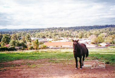
Photograph, View north east from Porter Street, Eltham, 1994, 1994_
Colour photograph of view north east from Porter Street, Eltham near Ely Street, 1994porter street, eltham -
 Federation University Historical Collection
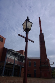
Photograph - Colour, Street Lamp at the Ballarat School of Mines, 2011
Billmans Foundry was established in Castlemaine in 1980.Three photographs showing a street lamp in Lydiard Street South. The lamp was made by Billmans Foundry, Castlemaine.lamp, gas lamp, ballarat school of mines, castlemaine, bilmans foundry, lydiard street -
Port Melbourne Historical & Preservation Society
Map - Lagoon between Ingles and Spring Streets, Sandridge, 26 Mar 1872
Prepared by Mr ORME for the Lagoon Committee and presented with a report on 26.3.1872.Map of Lagoon between Ingles Street and Spring Street. 26 March 1872. In brown wooden frameBorough Surveyor's Stamp in bottom right hand corner.sandridge lagoon, mr orme -
 Port Melbourne Historical & Preservation Society
Photograph - Bay Street and Faram Bros, Port Melbourne, 1980
B&W photo of Bay Street and Faram Bros from south of Raglan Street c 1980built environment - commercial, business and traders, business and traders - hardware, tony cannatelli, faram brothers hardware, bay street -
Port Melbourne Historical & Preservation Society
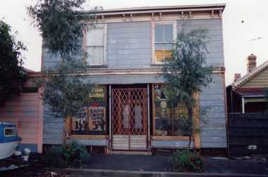
Photograph - Sweet Port, Bay Street, Port Melbourne, David Thompson, 1990s
One of five colour photographs of Port Melbourne streets: Sweet Port shop, 175 Bay Streetbuilt environment - commercial, bay street -
 Port Melbourne Historical & Preservation Society
Photograph - Former Peterson's Grocery, Stokes Street, Port Melbourne, David Thompson, Apr 1996
Photos taken during renovations, 1996, when shutters were removed revealing painted windowsFormer Peterson's grocery 175 Stokes Street (originally Bellion's, 1881) Street view of building in 1996built environment - commercial, business and traders - grocers and supermarkets, david thompson, helen leitch, a peterson -
 Bendigo Historical Society Inc.
Slide - CASTLEMAINE HISTORICAL SOCIETY COLLECTION, CONSERVATORY GARDEN, BENDIGO, 1957
Slide. Conservatory Garden, Bridge Street Bendigo. Looking at Law Courts and Bull Street. Dated 25.3.57slide, bendigo, conservatory gardens, castlemaine historical society collection conservatory gardens bendigo law courts bull street view -
 Victorian Interpretive Projects Inc.
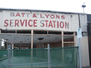
Photograph - Colour, Clare Gervasoni, Batt and Lyons Service Station, Ballarat, 20/03/2011
When this shop was gutted to become a Subway the remnants of a former use were uncovered. It caused interest in Ballarat so the building redevelopment quickly proceeded. This photograph was taken during the few days when the Batt and Lyons evidence was on show.Photograph of a shop on the corner of Sturt Street and Raglan Street Ballarat undergoing refurbishment. It was redeveloped into a Subway (2012).ballarat, service station, batt, lyon -
Tatura Irrigation & Wartime Camps Museum
Photograph, Thomas Hogan Residence
Home of Thomas Hogan, north side of Hogan Street, east of Ross Street. Residents posing on verandah.tatura, buildings, historic -
 Clunes Museum
Photograph
BLACK AND WHITE PHOTOGRAPH FRASER STREET, CLUNES. CROWD WATCHING BACK TO CLUNES STREET PARADE 1982local history, photography, photographs, events and celebrations, back to clunes 1982 -
 Clunes Museum
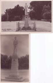
Photograph, UNKNOWN
BLACK & WHITE POSTCARD PHOTOGRAPH SOLDIERS MEMORIAL, CLUNES, CORNER FRASER STREET AND SERVICE STREET, CLUNES. local history, photography, photograph, monuments, memorials soldiers gold -
 Ballarat Heritage Services
Photograph, Clare Gervasoni, House in Lyons Street South, Ballarat, 2020, 13/04/2020
Colour photograph of a former corner store in Lyons Street South, Ballarat, near the intersection of Sebastopol Street.ballarat, cast iron, lyons st, lyons street south, architecture -
 Ballarat Heritage Services
Photograph, Clare Gervasoni, Former Corner Store in Lyons Street South, Ballarat, 2020, 13/04/2020
Colour photograph of a former corner store in Lyons Street South, Ballarat, near the intersection of Sebastopol Street.ballarat, cast iron, lyons st, lyons street south, architecture -
 Ballarat Heritage Services
Photograph, House on the corner of Lyons Street South and Dana Street, Ballarat Central, 2020, 21/04/2020
A large double storey building on the corner of Lyons Street South and Dana Street, Ballarat Central, 2020lyons st south, architecture, dana street, ballarat -
 Ballarat Heritage Services
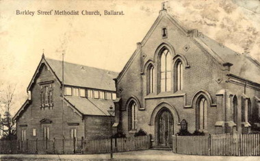
Photograph, Barkly Street Uniting Church
Postcard showing Ballarat's Barkly Street Methodist Church, later known as Barkly Street Uniting Church.A plaque reads "This plaque is in memory of the pioneers of this community and the Methodist Church est circa 1853 in a canvas tent. This brick building was built in 1859 with collections from the congregation. First Minister of the church was the Reverend Theopholis Taylor 1829 ~ 1858 -and the Methodist Church in 1977 became part of the Uniting Church in Australia.barkly street uniting church, barkly street methodist church, religion, theopholis taylor -
Lakes Entrance Regional Historical Society (operating as Lakes Entrance History Centre & Museum)
Postcard, Murray Views Gympie Qld, 1950 c
Coloured postcard of Victoria Hotel on south east corner of Main Street and McMillan Streets Bairnsdale VictoriaMurray Views No 5 Victoria Hotel Bairnsdale Vicbuildings, police -
 Kew Historical Society Inc
Photograph - 'Roseneath', 37 Pakington Street, 1979
In 1979, a series of photographs of significant gardens in Kew (Victoria) were taken during a tour by Peter Watts, Historic Gardens Coordinator of National Trust Victoria. These were later purchased to add to the collection. In the case of each photo the colour had badly degraded over time. Original colour (degraded) positive photograph of the coach house of 'Roseneath', 37 Pakington Street Street, Kew.Annotated in ink reverse: "Coach House Roseneath / Peter Watts National Trust Historic Gardens Coordinator / Donated by Mavis Rolley"gardens -- kew (vic.), pakington street -- kew (vic.), roseneath -
Canterbury History Group
Photograph - Street view of shop at No. 94 Maling Road, Jan Pigot, 1994
Coloured photograph of the street view of the Pharmacy on the corner of Maling Road and Bryson Street at No. 94 Maling Roadcanterbury, maling road, shops, signs -
 Melton City Libraries
Photograph, Court House, c.1970
The Court House and Police Station would have be built between 1892-1900. The Constables in 1900 was McGuire, later Wade, Riely and McKenzie after that Robert Wilson and Seinfort were here, they were a bit later on. Information from reel to reel tape recording of Tom Collins in Melton 1969. Front and side views of the Court House, located near the corner of High street and Palmerston Street, Melton. emergency services, local architecture -
 Kew Historical Society Inc
Plan, Melbourne & Metropolitan Board of Works : Borough of Kew : Detail Plan No.1590, 1905
The Melbourne and Metropolitan Board of Works (MMBW) plans were produced from the 1890s to the 1950s. They were crucial to the design and development of Melbourne's sewerage and drainage system. The plans, at a scale of 40 feet to 1 inch (1:480), provide a detailed historical record of Melbourne streetscapes and environmental features. Each plan covers one or two street blocks (roughly six streets), showing details of buildings, including garden layouts and ownership boundaries, and features such as laneways, drains, bridges, parks, municipal boundaries and other prominent landmarks as they existed at the time each plan was produced. (Source: State Library of Victoria)This plan forms part of a large group of MMBW plans and maps that was donated to the Society by the Mr Poulter, City Engineer of the City of Kew in 1989. Within this collection, thirty-five hand-coloured plans, backed with linen, are of statewide significance as they include annotations that provide details of construction materials used in buildings in the first decade of the 20th century as well as additional information about land ownership and usage. The copies in the Public Record Office Victoria and the State Library of Victoria are monochrome versions which do not denote building materials so that the maps in this collection are invaluable and unique tools for researchers and heritage consultants. A number of the plans are not held in the collection of the State Library of Victoria so they have the additional attribute of rarity.Original survey plan, issued by the MMBW to a contractor with responsibility for constructing sewers in the area identified on the plan within the Borough of Kew. The plan was at some stage hand-coloured, possibly by the contractor, but more likely by officers working in the Engineering Department of the Borough and later Town, then City of Kew. The hand-coloured sections of buildings on the plan were used to denote masonry or brick constructions (pink), weatherboard constructions (yellow), and public buildings (grey). Surveyed by the Board of Works in 1903 and published in 1904, Plan No.1590 shows development north of Cotham Road. While this plan includes built structures in Mary Street, Cotham Road, High Street, Park Hill Road, Kent Street, Ridgeway Avenue, and Ermington Lane (now Ermington Place), only part of this section was notated and coloured in this contractor’s copy. Numerous houses, large and small are named on the plan: ‘Cholula’, ‘Belper’, ‘The Uplands’, ‘Spring Grove’ facing Cotham Road; ‘Marion’ facing Kent Street; and ‘Kia Ora’ facing Ridgeway Avenue.melbourne and metropolitan board of works, detail plans, mmbw 1590, survey plans - borough of kew, cartography -
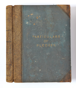 Port Melbourne Historical & Preservation Society
Book - Johnny ALLSORTS, Pawn shop, Bay Street, Port Melbourne, Particulars of Pledges, c. 1891
Kept by Robert POWELL at 175 Bay Street, Port Melbourne, and discovered c1980 at rear of the premises 173 by Arnold GOETZ of Alfred M NOTT when moving in. (Fred NICHOLAS, Chemist, had been previous occupant for 50 years). 'Particulars of pledges' register from pawn shop Johnny Allsorts of Bay Street. Dark blue fabric cover bound in leather. One of three from the 1890s, this from 22.4.1891 to 23.3.1892depression, business and traders - pawnbrokers, robert powell, elizabeth powell, bay street, johnny allsorts pawnbroker, arnold w goetz -
 Melbourne Legacy
Photograph, Hibernian Hall, 30/6/1947
A photo of the first property owned by Legacy, at 342 Swanston Street. After receiving money in memory of David H Dureau to purchase premises, Legacy purchased the old Hibernian Hall. However there were many issues with the property, including its suitability and the inability to gain vacant possession from the existing tenants. So eventually the property was sold and the money used to buy the current Legacy House, still formally known as the David H Dureau Memorial Building as per the bequest instructions. The notes on the back of the photo say it was sold to Sir Bernard Evans and then to RMIT and it was renamed Storey Hall. The full story of the donation has been pieced together from several sources. Part of the story of the donation towards Dureau House. BG Corporation in New York used 'Brown and Dureau' as agents in Melbourne for their spark plug manufacturing (for the American aircraft based in Australia during the war). A royalty of two shillings and sixpence was agreed. The entrepreneur President of BG Corporation was Richard Goldsmith. L/ Grat Grattan had a friend Mr Edwards who was managing director at Brown and Dureau and heard of the desire by Mr Goldsmith to leave a permanent memorial to ex-servicemen in Australia (Children's Hospital was considered). L/ Grattan took Mr Edwards to Market St (where Legacy was situated at the time) and showed him the inadequacy of the building. It was agreed if Melbourne Legacy could come up with a purchased building in 10 days they would get the money needed and the building was to be named in memory of David H Dureau, who had died at sea during the war. The donation was £27,059. The property purchased was 'Hibernian Hall' in Swanston St (later called Storey Hall when it was acquired by RMIT). After the war it turned out not to be suitable and a new building was required. An act of parliament was required to enable the sale (01262) and consent from the donor was also sought before the sale (document still to be catalogued). Money raised from the sale was used to purchase 293 Swanston St.A photo of the first property purchased by Legacy as a result of a generous donation.Black and white photo of the old Hibernian Hall in Swanston Street.Handwritten on back 'The old Hibernian Hall purchased by Melbourne Legacy and later sold because of inability to secure vacant possession from tenants. Sold to Sir Bernard Evans then to RMIT and named 'Storey House', in pencil. Stamped '30 Jun 1947' in purple inkproperties, dureau house, swanston st -
Port Melbourne Historical & Preservation Society
Photograph - Presbyterian kindergarten children, c. 1949
Photo of Garry COSHAM (second from right in the back row, the port side of the boat) and other Presbyterian kindergarten children c1949. Also visible in the photo is the surgery/home of Dr. GROVER at 141 Bridge Street (south-east corner of Nott Street), Creswick House at 139 Bridge Street, the grocer shop and residence at 180-2 Nott Street (north-east corner of Bridge Street) and residences at 184 and 186 Nott Street.education - kindergartens, religion - presbyterian church, garry cosham, harley grover, creswick house -
 Rutherglen Historical Society
Post Card, various
Three black and white photographs of old postcards, mounted on a sheet of decorative grey paper. Top one is a view of Main Street, Rutherglen, looking west, featuring Younkman's Store and the Victoria Hotel. Middle one is also of Main Street, looking west, featuring the Star Hotel at the corner of High Street, with horses and carts in the street. Bottom one is of the Victoria Hotel in Main Street, with cars of 1970s vintage parked along the street.Centre photo has an upside down post mark: "Sydney | Jan 5 | 12 [illeg.] | 1909 | 75"main street, high street, star hotel, victoria hotel, s younkman & co -
 Kew Historical Society Inc
Plan - Subdivision Plan, Palmyra Estate, 1918
Pru Sanderson, in her groundbreaking ‘City of Kew Urban Conservation Study : Volume 2 - Development History’ (1988), summarised the periods of urban development and subdivisions of land in Kew. The periods that she identified included 1845-1880, 1880-1893, 1893-1921, 1921-1933, 1933-1943, and Post-War Development. These periods were selected as they represented periods of rapid growth or decline in urban development. An obvious starting point for Sanderson’s groupings involved population growth and the associated economic cycles. These cycles also highlighted urban expansion onto land that was predominantly rural, although in other cases it represented the decline and breakup of large estates. A number of the plans in the Kew Historical Society’s collection can also be found in other collections, such as those of the State Library of Victoria and the Boroondara Library Service. A number are however unique to the collection.The Kew Historical Society collection includes almost 100 subdivision plans pertaining to suburbs of the City of Melbourne. Most of these are of Kew, Kew East or Studley Park, although a smaller number are plans of Camberwell, Deepdene, Balwyn and Hawthorn. It is believed that the majority of the plans were gifted to the Society by persons connected with the real estate firm - J. R. Mathers & McMillan, 136 Cotham Road, Kew. The Plans in the collection are rarely in pristine form, being working plans on which the agent would write notes and record lots sold and the prices of these. The subdivision plans are historically significant examples of the growth of urban Melbourne from the beginning of the 20th Century up until the 1980s. A number of the plans are double-sided and often include a photograph on the reverse. In 1918, Punch reported the sale of the Palmyra Estate. ‘Adjoining the Findon Estate at Kew is Palmyra, one of the most charming localities in this most desirable of all suburbs. Palmyra has frontages to Findon, Bakewell, Carson and Stevenson streets. Facing Carson street are eight blocks of 60 by 140; on Stevenson-street four of 60 by 232; and there are four of 60 by 233 on Bakewell-street.’ [Bakewell Street and Findon Street were later to be amalgamated into Findon Crescent.]subdivision plans - kew, studley park, palymyra estate, stevenson street -- kew (vic.), carson street -- kew (vic.), bakewell street (findon crescent) -- kew (vic.) -
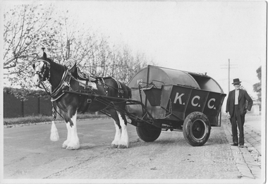 Kew Historical Society Inc
Photograph - City of Kew Horse, Cart and Employee, Stuart Tompkins, c.1950
The Kew City Council Depot was for a period situated on the corner of High Street and Disraeli Streets. The photo from the former City of Kew Municipal Collection was taken by a photographer from Stuart Tompkins Studio in Camberwell.One of four black and white photographs (perhaps reproductions) of a horse and cart and a council employee in Parkhill Road, Kew. In a number of photos the cart has K.C.C., in large letters on its side. It is presumed to be the city garbage cart No.3 which was stationed at the old Council Depot on the corner of High and Disraeli Streets. "Cr Parkhill Rd & Hillcrest Ave Kew / Driver : Barry Avery"city of kew, garbage waste collection - kew (vic), barry avery, kew depot, stuart tompkins -
 Ballarat Heritage Services
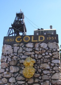
Photograph, Dorothy Wickham, Gold Monument, Ballarat, c2010
Gold was discovered in Ballarat in 1851 when many people rushed to the diggings. A monument commemorates the centenary of the finding of gold at Poverty Point and is dedicated to the memory of pioneer miners of Ballarat. It records gold yields, nuggets and the richest recorded yields of both alluvial and quartz mines. The replica gold nugget on the monument is the `Welcome Nugget`, found in Ballarat in 1858, weighed 2,217 ounces and was sold for £10,500. The memorial, known as the Pioneer Miners’ Monument, was made to commemorate Ballarat's gold centenary. It was proposed that part of the Pioneers' Memorial Fund might be used. This fund was started with £1300 profit from the 1938 centenary celebrations. (Age (Melbourne), The monument was created by John Edward Skilbeck, a toolmaker with Ronaldson and Tippett. John Skilbeck had a deep interest in Ballarat History, and undertook much research with Bert Strange and Keith Stacpoole. Councilllor William Ernest Roff provided the copper for the memorial from scrap copper obtained during his plumbing business. The copper was reworked by John Skilbeck, and was soldered in the kitchen of his home at 14 Frank Street. Colour photograph of the gold monument on the corner of Sturt Street and Albert Street, Ballarat. It commemorates the discovery of gold at Poverty Point in August 1851, and was The monument was unveiled in 1951 and is mainly constructed of large piecesof quartz, with a miniature popper head on the top made of copper. Mounted on the side is a replica of the Welcome Nugget, which was unearthed on the corner of Humffray and Mair Streets, Ballarat on 09 June 1858.FRONT This monument was erected by the Ballarat Historical Society to commemorate the finding of gold at Poverty Point 21st August 1851 and is dedicated to the memory of/ pioneer miners of Ballarat LEFT SIDE Richest recorded yields alluvial mines Band of Hope 303269 Ozs Prince of Wales 168929 Koh I Noor 164157 Great Redan Ex 110111 Albion 107125 Bonshaw Fr 96520 Park 94699 St George 86702 Sir Wm Don 76830 Hand in Hand 76830 Sir Henry Loch 43562 Quartz Mines Star of the East 256758 Ozs Band of Hope 158299 Victoria United 152013 N Woah Hawp 129562 New Normanby 127562 Britannia 103225 Llanberris No 1 100533 Black Hill 91665 Last Chance U 83766 Llanberris 71364 Speedwell 66000 South Star 64444 Sulieman Pasha Companies 62666 RIGHT Recorded gold yield 20606000 ozs Nuggets Alluvial Welcome 2217 ozs Saraha Snads 1619 Lady Hotham 1177 Canadian 1 1117 Canadian 2 1011 Koh 1 Noor 834 Eureka 625 Lady Loch 617 Prince of Wales 606 Bakery Hill 571 Native Youth 540 Faboulous yields of earliest diggings not offically recorded Quartz Nuggets N Woah Hawp 5-- 300 200 Ozs White Horse 500 Woah Hawp 444 266 262 Canton 257 200 Q Victoria lease 410 U Black Hill Coy 315 Tinworths 250 Parade Coy 245gold monument, ballarat, skilbeck, poppet head, j.e. skilbeck, john skilbeck -
Pyrenees Shire Council
photograph, Avoca in 1866 by J.N. Dallimore, 1866
J.N. Dalimore was an amateur photographer and settler who arrived at Port Phillip (Victoria) with his wife in September 1840 on board the Himalaya. Dalimore lived at Woodstock Station, near Avoca, he exhibited view photographs of the district at the 1866 Melbourne Intercolonial Exhibition that were sent on to the 1867 Paris Universal Exhibition. The Avoca Mail of 7 November 1866 reported: Mr Dallimore of Woodstock, determined that the town of Avoca and its environs shall be pictorially represented at the Victorian and Paris Exhibitions, has we learn, forwarded a series of photographs representing the High Street and the Pyrenees [Victoria] from different points of view. All the photographs are well executed and will possess considerable interest for the friends of Avocaites visiting the World’s Fair in 1867. Also included were views of Dallimore’s own station. They won him a medal 'for good Landscape Photography’. His panoramic photograph of Avoca is in the Shire Council significant as a historic photograph of Avoca, locally significant to the Central Highlands Region of Victoria as a representation of local landscape and/or culture Black and white photograph of Avoca showing Rutherford Street to the left and the original site of the Avoca Hotel"verso (affixed): AVOCA MAIL, 1st JUNE 1867. ""A remarkably well-executed photograph of the town of Avoca taken in 1866. and forming one of the exhibits at the Melbourne Exhibition, has been presented to the Avoca Shire Councilby F.W. Dalimore formally of Woodstock verso (affixed): No. 875 Intercolonial Exhibition 1866 Exhibitor: Avoca Shire Council Class: Section:" -
Port Melbourne Historical & Preservation Society
Photograph - Demoliton, New Great Britain Hotel, 197 Stokes Street, Port Melbourne, Lloyd Finch, Apr 2003
Owners of the former New Britain, Phil and ? COLLINS over 2003-2004 demolished portions and extended the structure. Added upper decks, swimming pool etc. Aptil demolition was recorded by neighbour Lloyd FINCH from roof of 201 Stokes Street.Photos taken during demolition of back New Britain Hotel, 197 Stokes Street. From roof of 201 Stokes Street by owners L&A FINCH, April 2003. .01 - .03 View of partially demolished back room, morning sun (vertical) .04 - More demolition .05 - Partially demolished dunny .06 - More demolition .07 - .08 South west corner cold storage, wide view .09 Envelope portiondemolitions, hotels, phil collins, lloyd finch, new great britain hotel, built environment - commercial, built environment - domestic, stokes street