Showing 5064 items matching " victoria st"
-
 St Kilda Historical Society
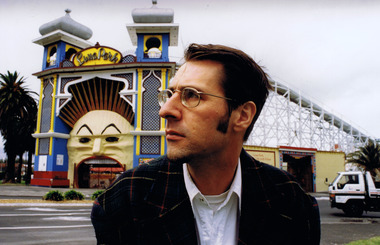
Photograph, Nigel Male, Rohan Storey
Rohan Storey, Architectural Historian of the National Trust of Australia (Victoria) 1990-2011.colour photograph unmountedPhotograph by Nigel Maleluna park, st kilda, rohan storey, national trust -
 St Kilda Historical Society
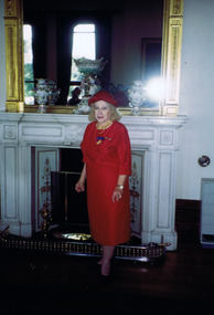
Photograph, Patricia Agnes Penrose OAM, 7 May 1993
Patricia Agnes Penrose (nee Rattray) OAM Convenor Australian Women's Army Service, Royal Australian Corps of Signals. She was awarded the OAM in the Australia Day 1993 Honours List for 'service to veterans and to the community'. She passed away at home on June 27, 2006. Colour photograph unmountedInvestiture of Patricia Agnes Penrose with the Order of Australia medal by his Excellency the Governor of Victoria, the Honorable Richard E McGarvie, at Government House Melbourne, 7 May 1993. Photo taken at reception given afterwardspatricia agnes penrose oam, patricia penrose, australian women's army service, royal australian corps of signals -
 St Kilda Historical Society
Photograph, 'Glen Huntley' 150th anniversary of arrival - images collection
... Carlisle Street St Kilda melbourne Victorias first quarantine ...Victorias first quarantine station was established in Port Ormond on 24 April 1840 when the government immigrant ship "Glen Huntley" arrived in the Port Phillip District flying the yellow quarantine flag . The site is marked by a cairn and plaque that was unveiled in 1985. In 1990 a second plaque was affixed to the cairn to mark the 150th anniversary of the arrival of the ship. It was unveiled at a gathering of descendants of the original passengers on 22 April 1990 by the oldest known descendant, Albert John Buntine MM.Colour photographInscription on 150th anniversary plaque: This plaque commemorates the 150th anniversary of the arrival of the ship 'Glen Huntley' at a gathering of descendants of the original passengers. Unveiled on April 22nd 1990 by Albert John Buntine MM, aged 95. Oldest known descendent. Anderson, Davidosn, Dingwall, McCleery, McDougal, McIntosh, Pattison, Somerville, Brisbane, Kirkwood, McGaskell, McDonald, McGregor, McKenzie, Turnbull, Walker, Armstrong, Henderson, Mathewson, McPherson, Robertson, McKinnon, Whitlock, Stewart, Cameron, Cummins, Hewison, Maskill, Mathers, McKinan, McKinny, McLaren, Burnie, Clarke, Denham, Fraser, Harper, Mercer, McColl, McLeod, Clarke, Duff, Roy, Seat, Stow, Tait, Ward, Craig, Grant, McKay, Mefan, Munro, Nicol, Smith, Young. The plaque marking the 150th anniversary of the ship's arrival was placed below the plaque that was attached to the cairn in 1985. The inscription on the original plaque is: This cairn marks the site of Victorias first quarantine station, which was established on the 24th April 1840 when the government emigrant ship "Glen Huntley" arrived in the Port Phillip District flying the yellow quarantine flag. The site became St Kilda's first official burial ground and the graves of the early colonists remained here until 1898 when the remains were re-interred in the St Kilda Cemetery. Unveiled by the Hon. R W Walsh MLA Member for Albert Park, Minister for Public Works, Assistant Minister for Employment and Industrial Affairs, 7th November 1985. This project was initiated by the Historical Society of St Kilda and sponsored by the Lions Club of Elwood for the 150th Anniversary of the State of Victoria. Logo Victoria 150.glen huntly, glenhuntly, albert john buntine, elwood, point ormond, glen huntley -
 St Kilda Historical Society
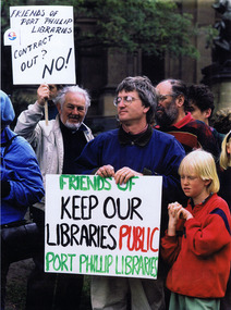
Photograph, 1996
Protest by the Friends of Port Phillip Libraries (FOPPL) outside the State Library of Victoria about the contracting out of Port Phillip Library Services in 1996. According to the FOPPL, this was the only documented case of privatisation of a public library service in Australia. Archives of the campaign: St Kilda Historical Society.Colour photographL to R Colin S Watson, Hans Lofgren, Kai Lofgren. Demonstration at State Library of Victoria by Friends of Port Phillip Libraries, 1996, opposing contracting out of the library service, City of Port Phillip. Only documented case of privatisation of a public library service in Australia. Archives of the campaign: St Kilda Historical Society.st kilda, port phillip, port phillip library, port phillip library service, 1996 -
 St Kilda Historical Society
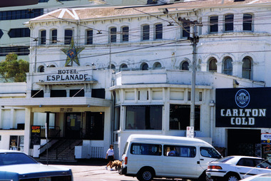
Photograph, Hotel Esplanade
Formerly New Bath & Criterion, built in 1856. New Bath demolished in the 1860s. A new hotel was built in 1878 and altered in 1921, when it changed hands and an entertainment venue was incorporated into the former exclusively residential building. Famed for live music, it is one of the earliest, largest and most prominent 19th-century resort hotels in Victoria. It has been altered many times since and this image predates extensive renovations and restoration work in 2018.colour photographst kilda, esplanade hotel, hotel esplanade, the espy, the esplanade -
 St Kilda Historical Society
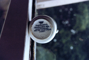
Photograph, George Hotel demitasse coffee cup - images collection
The George Hotel in St Kilda was one of the largest and most well known hotels in Victoria and the largest in Melbourne outside the city. By the late 1970s and early 1980s, renamed the Seaview in 1976, it no longer operated as a hotel and fostered Melbourne's alternative and punk music scenes. It was de-licenced and closed in 1987 and redeveloped in the mid 1990s as apartments, with bars, cafes and shops at ground level and an art gallery and cinema. On 6 January 1996, Harry Hogg, a local photographer and a member of the Save St Kilda movement, sent the photographs of the demitasse coffee cup to the new owner of The George, Donlevy Fitzpatrick. His covering letter said: 'The reason for this note is to send you copies of photographs of a fragment of a demitasse coffee cup I unearthed recently from along the light rail in Albert Park. I regret the poor quality of the prints (I was funning a test on a 1000 ASA film in low flat light) but hope the contents of the photographs may be of interest to you.'Colour photographSide of cup: George Hotel St Kilda; image of warrior on horse Base of cup: Dunn Bennet's (Gold Medal) Hotel Ware. Burslem, England. Made for: J. Leigh Jones & C Sydney.st kilda, dunn bennett, george hotel, fitzroy street, donlevy fitzpatrick -
 St Kilda Historical Society
Photograph, City of St Kilda Centenary 1990 - images collection #2, 02/12/1990
St Kilda was declared a city on 2/12/1890 by the Governor of Victoria The Right Hon. John Adrian Louis Hope, the Earl of Hopetoun, GCMG (28/11/1889 - 12/07/1895). This event was commemorated 100 years later, on 2/12/1990, by the unveiling of a plaque by the current Governor Dr J. Davis McCaughey AC (18/02/1986 - 22/04/1992). Also in commemoration of the centenary, a conservatory in the St Kilda Botanical Gardens was opened that day by the Mayor, Cr. Melanie Eagle. Four years later, in 1994, the City of St Kilda was amalgamated with the cities of South Melbourne and Port Melbourne to form the City of Port Phillip.Colour photographst kilda, st kilda town hall, governor davis mccaughey, st kilda city centenary, 1990, john callanan, j davis mccaughey, melanie eagle -
 St Kilda Historical Society
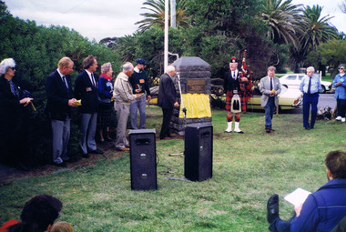
Photograph, 'Glen Huntley' Passengers Memorial Restoration 1992 - images collection, 1992
The memorial grave was dedicated on 16 April, 1899. Following the 150th anniversary of the arrival of the barque, descendants of John Craig and other "Glen Huntly" passengers restored the memorial. Descendants gathered in 1992 for the unveiling of a plaque marking the restoration.Colour photographRear of each photograph: SK Cemetery 1992 Glenhuntly Descendants. Inscription on memorial: On December 13th 1839, the emigrant ship "Glen Huntly" left Greenock, Scotland and arrived in Hobson`s Bay on 17th April 1840. Many of the passengers suffering from fever were landed at the Red Bluff St Kilda on 24th April 1849. That being the first quarantine station in Victoria. A few days later John Craig James Mathers George Armstrong succumbed to the disease and were interred at The Bluff. Owing to the encroachment of the sea their remains were exhumed and removed to the St Kilda Cemetery on 27th August 1898 by the Board of Public Health.This memorial was erected by public subscription, to mark a notable event in the early history of the colony. Inscription on plaque, unveiled in 1992: This memorial grave was restored by descendants of John Craig and of other "Glen Huntly" passengers. In April 1990 they commemorated the 150th anniversary of the arrival of the barque in Melbourne in 1840. 25th August 1991st kilda cemetery, glen huntly, john craig, james mathers, george armstrong, 1992, glen huntley -
 St Kilda Historical Society
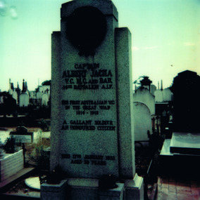
Photograph
... Dandenong Road, St Kilda East, Victoria, Australia ...Albert Jacka VC was born in Layard, near Winchelsea Victoria, on 10 January 1893. He was the first person in the AIF to be awarded the Victoria Cross, which he received for the first of many acts of heroism in WW I. After the war, on 17 January 1921, he married Frances Veronica Carey at St Mary's Catholic Church, St Kilda. They settled at St Kilda and later adopted a daughter. In September 1929. He was elected to the St Kilda Council and became mayor in 1930. He died on 17 January 1932 of chronic nephritis. Nearly 6000 people filed past his coffin when it lay in state in Anzac House. The funeral procession to St Kilda cemetery was led by over 1000 returned soldiers and was flanked by thousands of onlookers. He was buried with full military honours in the Presbyterian section. Eight Victoria Cross winners were his pallbearers. A memorial plaque and sculpture for his grave was paid for by public subscription and £1195 was raised towards buying his widow a house. The photograph was taken during a St Kilda Historical Society tour of St Kilda cemetery on 26 November 1978Colour Polaroid photographBus Trip 26/11/78. Jacka's Grave. SKHS 00761.st kilda, st kilda cemetery, graves, albert jacka, wwi, world war i, war heroes -
 St Kilda Historical Society
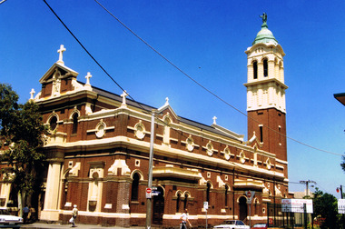
Photograph, Sacred Heart Church in St Kilda
... 83 Grey Street, St Kilda, Victoria, Australia ...The church was opened and dedicated on 7/12/1884, and completed in 1922. http://skhs.org.au/SKHSchurches/Sacred%20Heart%20Church.htmThe church is of architectural significance due to its Italian Renaissance Baroque Style, with red bricks, cement dressings and a slate roof. It indicated the abandonment of the Gothic Revival style favoured by Victoria's Roman Catholics and set the new style for subsequent Roman Catholic churches in Victoria. It was designed by Reed, Henderson & Smart. colour photographst kilda, churches, catholic churches, sacred heart -
 St Kilda Historical Society
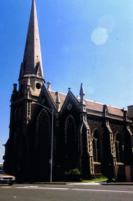
Photograph, St Kilda Presbyterian Church exterior - images collection, c 1970s
... 2 Alma Road, St Kilda, Victoria, Australia ...The St Kilda Presbyterian Church is now part of the St Kilda & Balaclava Presbyterian Church. Its first service was inaugurated by the Free Church Synod of Victoria in May 1855, in a building at the corner of High Street and Alma Road. In October 1855 the congregation moved to a wooden building in Inkerman Street, purchased from the Independent (Congregational) Church. The present church site was purchased and the first church opened in 1860. The foundation stone for the present church building, the second to be built on the site, was laid by the Governor of Victoria, Sir Henry Brougham Loch, on 27 January 1885. The building was opened on 30 May 1886. Wilson and Beswicke were the architects. Ralph Wilson designed the Methodist church on the corner of Princes and Fitzroy Streets and lived diagonally opposite the Presbyterian church. Charles Beswicke had toured Britain and the Continent in 1886 armed with a camera and returned to Australia with photographs of what he considered the greatest examples of architecture. He was responsible for the town halls in Brighton, Malvern, Hawthorn and Essendon and Wesleyan churches in Camberwell and Dandenong. Thomas Corley was the builder. The lofty spire was ‘a landmark to the mariner’ used by sea captains sailing up Port Phillip Bay. On a prominent position, the highest point in St Kilda, the church attracted wealthy people with legal, merchant and pastoral backgrounds.colour photographst kilda, churches, presbyterian church, balaclava -
 St Kilda Historical Society
Photograph - Photo map, 28/01/1951
One of a series of photo-maps produced for the Department of Crown Lands and Survey (1857-1983). For correlation with a current map, and access to other historical photo maps of Victoria, see the Historic Photo-Maps Index published by the Department of Environment, Land, Water and Planning at https://services.land.vic.gov.au/DELWPmaps/historical-photomaps/Black and white aerial photograph1424-45 SECRET 534 Run 18 Lens 12" Melbourne Metropolitan 12150 28.1.51 M639albert park, st kilda junction, st kilda pier, catani gardens, st kilda, prahran, albert park lake, 1951, middle park, st kilda beach, windsor -
 St Kilda Historical Society
Photograph - Photo map, 17/01/1951
One of a series of photo-maps produced for the Department of Crown Lands and Survey (1857-1983). For correlation with a current map, and access to other historical photo maps of Victoria, see the Historic Photo-Maps Index published by the Department of Environment, Land, Water and Planning at https://services.land.vic.gov.au/DELWPmaps/historical-photomaps/Black and white aerial photograph1414-21 538 Run 19 Lens 12" Melbourne Metropolitan 12150 17.1.51 M586st kilda, st kilda botanical gardens, peanut farm, elwood, 1951, point ormond, elwood canal, st kilda beach -
 St Kilda Historical Society
Photograph - Photo map, 28/01/1951
One of a series of photo-maps produced for the Department of Crown Lands and Survey (1857-1983). For correlation with a current map, and access to other historical photo maps of Victoria, see the Historic Photo-Maps Index published by the Department of Environment, Land, Water and Planning at https://services.land.vic.gov.au/DELWPmaps/historical-photomaps/Black and white aerial photograph1424-118 534 Run 20 Lens 12" Melbourne Metropolitan 12150 18.1.51M639elwood, point ormond, elwood park, elsternwick park, elwood beach, 1951 -
 St Kilda Historical Society
Photograph - Photo map, 17/01/1951
One of a series of photo-maps produced for the Department of Crown Lands and Survey (1857-1983). For correlation with a current map, and access to other historical photo maps of Victoria, see the Historic Photo-Maps Index published by the Department of Environment, Land, Water and Planning at https://services.land.vic.gov.au/DELWPmaps/historical-photomaps/Black and white aerial photograph1414-20 538 Run 19 Lens 12" Melbourne Metropolitan 12150 17.1.51 M586elwood, elsternwick, st kilda east, balaclava, ripponlea, 1951 -
 St Kilda Historical Society
Photograph - Photo map, 28/01/1951
One of a series of photo-maps produced for the Department of Crown Lands and Survey (1857-1983). For correlation with a current map, and access to other historical photo maps of Victoria, see the Historic Photo-Maps Index published by the Department of Environment, Land, Water and Planning at https://services.land.vic.gov.au/DELWPmaps/historical-photomaps/Black and white aerial photograph1424-44 534 Run 18 Lens 12" Melbourne Metropolitan 12150 28.1.51 M639 -
 St Kilda Historical Society
Photograph - Photo map, 28/01/1951
One of a series of photo-maps produced for the Department of Crown Lands and Survey (1857-1983). For correlation with a current map, and access to other historical photo maps of Victoria, see the Historic Photo-Maps Index published by the Department of Environment, Land, Water and Planning at https://services.land.vic.gov.au/DELWPmaps/historical-photomaps/Black and white aerial photograph1424-43 534 Run 18 Lens 12" Melbourne Metropolitan 12150 28.1.51 M639armadale, malvern, st kilda cemetery, caulfield north, st kilda east, 1951 -
 St Kilda Historical Society
Photograph - Photo map, 30/01/1960
One of a series of photo-maps produced for the Department of Crown Lands and Survey (1857-1983). For correlation with a current map, and access to other historical photo maps of Victoria, see the Historic Photo-Maps Index published by the Department of Environment, Land, Water and Planning at https://services.land.vic.gov.au/DELWPmaps/historical-photomaps/Black and white aerial photographVic 1093-62 Melbourne & Metropolitan Project Run 21 30.1.60 Lens 10" 8.200middle park, albert park, catani gardens, st kilda west, 1960 -
 St Kilda Historical Society
Photograph - Photo map, 30/01/1960
One of a series of photo-maps produced for the Department of Crown Lands and Survey (1857-1983). For correlation with a current map, and access to other historical photo maps of Victoria, see the Historic Photo-Maps Index published by the Department of Environment, Land, Water and Planning at https://services.land.vic.gov.au/DELWPmaps/historical-photomaps/Black and white aerial photographVic 1093-60 Melbourne & Metropolitan Project Run 21 30.1.60 Lens 10" 8.200st kilda, albert park, prahran, windsor, south yarra, 1960 -
 St Kilda Historical Society
Photograph - Photo map, 30/01/1960
One of a series of photo-maps produced for the Department of Crown Lands and Survey (1857-1983). For correlation with a current map, and access to other historical photo maps of Victoria, see the Historic Photo-Maps Index published by the Department of Environment, Land, Water and Planning at https://services.land.vic.gov.au/DELWPmaps/historical-photomaps/Black and white aerial photographVic 1092-36 Melbourne & Metropolitan Project Run 22 30.1.60 Lens 10" 8.200st kilda, st kilda pier, st kilda beach, catani gardens, 1960 -
 St Kilda Historical Society
Photograph - Photo map, 30/01/1960
One of a series of photo-maps produced for the Department of Crown Lands and Survey (1857-1983). For correlation with a current map, and access to other historical photo maps of Victoria, see the Historic Photo-Maps Index published by the Department of Environment, Land, Water and Planning at https://services.land.vic.gov.au/DELWPmaps/historical-photomaps/Black and white aerial photographVic 1092-38 Melbourne & Metropolitan Project Run 22 30.1.60 Lens 10" 8.200st kilda, st kilda beach, st kilda pier, catani gardens, 1960, st kilda botanical gardens, peanut farm -
 St Kilda Historical Society
Photograph - Photo map, 30/01/1960
One of a series of photo-maps produced for the Department of Crown Lands and Survey (1857-1983). For correlation with a current map, and access to other historical photo maps of Victoria, see the Historic Photo-Maps Index published by the Department of Environment, Land, Water and Planning at https://services.land.vic.gov.au/DELWPmaps/historical-photomaps/Black and white aerial photographVic 1092-40 Melbourne & Metropolitan Project Run 22 30.1.60 Lens 10" 8.200st kilda east, balaclava, ripponlea, st kilda cemetery, 1960 -
 St Kilda Historical Society
Photograph - Photo map, 30/01/1960
One of a series of photo-maps produced for the Department of Crown Lands and Survey (1857-1983). For correlation with a current map, and access to other historical photo maps of Victoria, see the Historic Photo-Maps Index published by the Department of Environment, Land, Water and Planning at https://services.land.vic.gov.au/DELWPmaps/historical-photomaps/Black and white aerial photographVic 1092-42 Melbourne & Metropolitan Project Run 22 30.1.60 Lens 10" 8.200malvern, caulfield, caulfield park, 1960 -
 St Kilda Historical Society
Photograph - Photo map, 30/01/1960
One of a series of photo-maps produced for the Department of Crown Lands and Survey (1857-1983). For correlation with a current map, and access to other historical photo maps of Victoria, see the Historic Photo-Maps Index published by the Department of Environment, Land, Water and Planning at https://services.land.vic.gov.au/DELWPmaps/historical-photomaps/Black and white aerial photographVic 1091-112 Melbourne & Metropolitan Project Run 23East 30.1.1960 Lens 10" 8.200elwood, point ormond, elwood park, elwood canal, 1960 -
 St Kilda Historical Society
Photograph - Photo map, 30/01/1960
One of a series of photo-maps produced for the Department of Crown Lands and Survey (1857-1983). For correlation with a current map, and access to other historical photo maps of Victoria, see the Historic Photo-Maps Index published by the Department of Environment, Land, Water and Planning at https://services.land.vic.gov.au/DELWPmaps/historical-photomaps/Black and white aerial photographVic 1091-110 Melbourne & Metropolitan Project Run 23East 30.1.60 Lens 10" 8.200elwood, elsternwick, elsternwick park, ripponlea, st kilda east, caulfield, balaclava, 1960 -
 St Kilda Historical Society
Photograph - Photo map, 30/01/1960
One of a series of photo-maps produced for the Department of Crown Lands and Survey (1857-1983). For correlation with a current map, and access to other historical photo maps of Victoria, see the Historic Photo-Maps Index published by the Department of Environment, Land, Water and Planning at https://services.land.vic.gov.au/DELWPmaps/historical-photomaps/Black and white aerial photographVic 1091-1 Melbourne & Metropolitan Project Run 24East 30.1.60 Lens 10" 8.200elwood, elwood beach, elwood park, 1960 -
 St Kilda Historical Society
Photograph - Photo map, 30/01/1960
One of a series of photo-maps produced for the Department of Crown Lands and Survey (1857-1983). For correlation with a current map, and access to other historical photo maps of Victoria, see the Historic Photo-Maps Index published by the Department of Environment, Land, Water and Planning at https://services.land.vic.gov.au/DELWPmaps/historical-photomaps/Black and white aerial photographVic 1091-2 Melbourne & Metropolitan Project Run 24East 30.1.60 Lens 10" 8.200elwood, elwood park, elwood beach, elsternwick park, 1960 -
 St Kilda Historical Society
Photograph - Photo map, 3/3/1964
One of a series of photo-maps produced for the Department of Crown Lands and Survey (1857-1983). For correlation with a current map, and access to other historical photo maps of Victoria, see the Historic Photo-Maps Index published by the Department of Environment, Land, Water and Planning at https://services.land.vic.gov.au/DELWPmaps/historical-photomaps/Black and white aerial photographVic 1833 Melbourne 1963 Project Run 15 3.3.64 Lens 205 152.70 M/M 5.150 56prahran, fawkner park, south yarra, albert park, 1964 -
 St Kilda Historical Society
Photograph - Photo map, 14/12/1963
One of a series of photo-maps produced for the Department of Crown Lands and Survey (1857-1983). For correlation with a current map, and access to other historical photo maps of Victoria, see the Historic Photo-Maps Index published by the Department of Environment, Land, Water and Planning at https://services.land.vic.gov.au/DELWPmaps/historical-photomaps/Black and white aerial photographVic 1807 Melbourne 1963 Project Run 16 14.12.63 Lens 205 152.70 M/M 5.150 179st kilda, prahran, albert park, st kilda east, balaclava, 1963 -
 St Kilda Historical Society
Photograph - Photo map, 14/12/1963
One of a series of photo-maps produced for the Department of Crown Lands and Survey (1857-1983). For correlation with a current map, and access to other historical photo maps of Victoria, see the Historic Photo-Maps Index published by the Department of Environment, Land, Water and Planning at https://services.land.vic.gov.au/DELWPmaps/historical-photomaps/Black and white aerial photographVic 1807 Melbourne 1963 Project Run 16 14.12.63 Lens 205 152.70 M/M 5.150 181st kilda cemetery, caulfield north, st kilda east, armadale, malvern, 1963