Showing 5240 items
matching drawn-thread
-
 Ringwood and District Historical Society
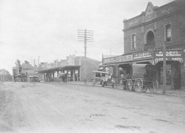
Photograph, Maroondah Highway Central, Ringwood. Coffee Palace and shops along Main Street between Adelaide Street and Melbourne Street. c1920's
Black and white photographWritten on back of photograph: "Land values - Main Street, Ringwood - land worth £50 pounds a foot." Image is taken from a land sale brochure and shows cars and horse drawn vehicles parked in front of buildings. -
 Flagstaff Hill Maritime Museum and Village
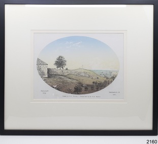
Drawing - Historical, Warrnambool, H. H. Ramsay, Flag-Staff Hill
The drawing is an artist's impression of Flagstaff Hill, Warrnambool, in 1855. It was presented to Flagstaff Hill Maritime Village by Mr R A Ramsay.The drawing is significant for its subject, a local maritime village and port. It is significant as a depiction of what the young town of Warrnambool could have looked like in 1855. Drawing in colour within an oval, with typed inscription below it. Mounted behind glass in a black rectangular frame with a cream matte. Artist's impression of Flagstaff Hill, town buildings of Warrnambool, Lady Bay with jetty, sailing ships in the bay, and Middle Island in the year 1855. Title; "Flag-Staff Hill", Artist; H. H. Ramsay It was presented to Flagstaff Hill by Mr R A Ramsay. Typed below the drawing; Left: "FLAG-STAFF HILL". Centre: "Drawn by Mr H. H. Ramsay - Presented by Mr R. A. Ramsay." Right: "WARRNAMBOOL IN 1855" On the back in pen "REC / 359A" (sighted before reframing)flag-staff hill, warrnambool 1855, drawing, local history, flagstaff hill maritime museum and village, great ocean road, shipwreck coast, h h ramsay, r a ramsay, flagstaff hill, warrnambool, flagstaff hill maritime museum, flagstaff hill maritime village, maritime museum, lady bay, middle island, coloured drawing, oval drawing -
 Flagstaff Hill Maritime Museum and Village
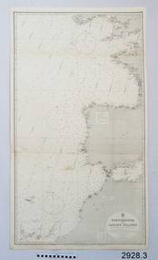
Document - Navigation Chart, Portsmouth to Canary Islands, Ca. 1928
This is an Official British Admiralty Navigation Chart, one of a set of 65 charts donated together with a wooden chart case. It was published and printed in London in 1928 by the British Admiralty. Navigation charts are drawn by professional hydrographers and describe the geography of land and water, enabling a water based navigator on board vessels such as ships to safely negotiate between ports locally and around the world. They are drawn to a particular standard with common symbols noting landmarks. The charts are used in conjunction with other navigational instruments and tools to calculate the vessel’s exact location and a safe route to its destination.The set of charts and their chart are of significance as examples of equipment and documents used to navigate the oceans of the world, particularly to Australia. Migration to Australia is an important part of this country's history.British Admiralty Navigation Chart - Portsmouth to Canary Islands - printed on rectangular white paper. Published in London by the British Admiralty in 1928.warrnambool, shipwreck coast, flagstaff hill, flagstaff hill maritime museum, flagstaff hill maritime village, chart, map, navigate, navigation, location, vessel, 1928, british admiralty, hydrographer, geography, admiralty chart, portsmouth, canary islands -
 Flagstaff Hill Maritime Museum and Village
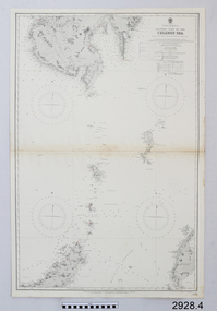
Document - Navigation Chart, Eastern Part of the Celebes Sea, Ca. 1928
This is an Official British Admiralty Navigation Chart, one of a set of 65 charts donated together with a wooden chart case. It was published and printed in London in 1928 by the British Admiralty. Navigation charts are drawn by professional hydrographers and describe the geography of land and water, enabling a water based navigator on board vessels such as ships to safely negotiate between ports locally and around the world. They are drawn to a particular standard with common symbols noting landmarks. The charts are used in conjunction with other navigational instruments and tools to calculate the vessel’s exact location and a safe route to its destination.The set of charts and their chart are of significance as examples of equipment and documents used to navigate the oceans of the world, particularly to Australia. Migration to Australia is an important part of this country's history.British Admiralty Navigation Chart - Eastern Part of the Celebes Sea - printed on rectangular white paper. Published in London by the British Admiralty in 1928.warrnambool, shipwreck coast, flagstaff hill, flagstaff hill maritime museum, flagstaff hill maritime village, chart, map, navigate, navigation, location, vessel, 1928, british admiralty, hydrographer, geography, admiralty chart, celebes sea -
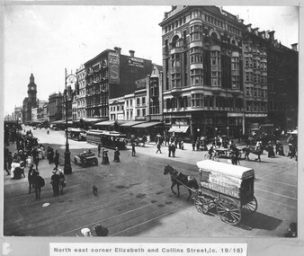 Melbourne Tram Museum
Photograph - Cable trams - Elizabeth and Collins St, 1918
Photograph shows the intersection of Elizabeth and Collins Sts Melbourne, looking North East. There are two cable trams in the view in Elizabeth St, one with a bogie trailer. There are a number of horse-drawn carts, one motor vehicle and many pedestrians crossing the streets. In the view are the GPO, a building advertising Kodak Australasia at the Block, The Windsor magazine, W E Thomas Dentist, and Dunklings. By the Dunklings store is a double decker bus with the destination of Spring St, advertising Zebra stove polish. The horse drawn covered cart is Geo Thomson Dairy Produce Merchant.Yields information about the intersection of Collins and Elizabeth St c1918Black and white print, mounted onto mauve coloured card with a printed title.tramways, cable trams, elizabeth st, collins st, buses, horse drawn vehicle -
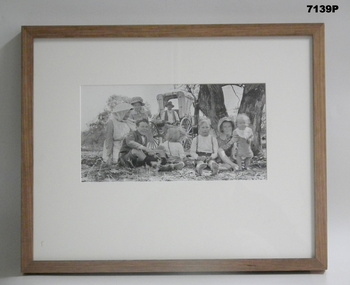 Bendigo Military Museum
Photograph - PHOTOGRAPH, FRAMED WW1, Wayne Eels, C.2008/2009
The Grinton Collection. Life after 1919, Grinton relatives. Refer Cat No 1280 for Jack Grintons service details.Photograph - Framed. Photograph - black and white photograph on paper depicting two adults and six children sitting on the ground under a tree. In background, two tree trunks and a horse drawn buggy. Frame - Timber, light varnish finish, Perspex front, cardboard backing."Group 6: Life after 1919". "G. Grinton relatives".framed accessories, camera on the somme, ww1, 38th bn, grinton -
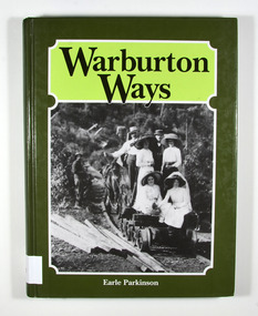 Marysville & District Historical Society
Book, Warburton Ways, 1993
A history of Warburton and its pioneersHardcover. Front cover has a photograph of a group of people sitting on a small railway cart which is being drawn by horse along a railway track. There is also a man standing to the left of the railway track. The photograph appears to have been taken in the late 1800's.With best wishes / Earle Parkinson Dedicated/ to the pioneer men/ and women who/ gave to us the/ Upper Yarra Valley/ -an inheritance/ so well worth/ preserving Stamp of Marysville & District / Historical Society Inc / P.O. Box 22 / Marysville 3779warburton, yarra ranges, victoria, australia, history, pioneers -
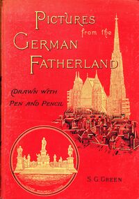 Bendigo Historical Society Inc.
Book - STRAUCH COLLECTION: PICTURES FROM THE GERMAN FATHERLAND, 1893
Hard covered book titled Pictures from the German Fatherland, drawn with Pen and Pencil, red cover with gold & black lettering, 224 pages with black and white illustrations, gold edging on pages, an inscription dated 1907 written in German inside front page.S G Greenheritage, history-germany-german heritage -
 Bendigo Historical Society Inc.
Map - MAP - THE INFANCY OF BENDIGO - GOLDEN SQUARE IN 1851
Hand-drawn map of Bendigo - Golden Square in 1851. Map shows the chain of waterholes, Golden Gully, hill and bush areas and open treeless flat. Mentioned on the map are places where there were mia mias, stockyards, Gibson & Fenton's butchery & First Store.map, bendigo, goldfields, map the infancy of bendigo & golden square 1851, capt dane, william johnson, mrs kennedy, mrs farrell, ben hall, chris asquith, gibson & fenton's butchery & first store, p odonnell, walter r sandbach, william sandbach, mr frencham, john ross, thos myers, bendigo hut & little stockyard, commissioner horne, j jones, c cohen -
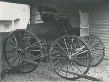 Bendigo Historical Society Inc.
Photograph - FERNIHURST ESTATE - HORSE DRAWN VEHICLE
black and white photo: horse drawn vehicle,4 wheels, 1 seat facing forward. Situated in small profile corrugated iron shed, stone rendered building in background. On back MP 113, '56' Handwritten ' J. Evans, Fernihurst Estate, Fernihurst 'J. Evans ?place, transport, horse drawn vehicle -
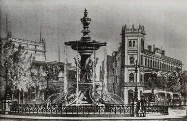 Bendigo Historical Society Inc.
Photograph - ALEXANDRA FOUNTAIN AND CITY FAMILY HOTEL
Black and white copy of a hand drawing, mounted on cardboard of the Alexandra Fountain and the City Family Hotel with handsome cabs. No inscriptions. History: Appears to be a hand-drawn image of what the area MAY have looked like at a certain, unknown, time. Probably of no historical merit.place, streetscape, view point -
Bendigo Historical Society Inc.
Map - TALAMBE : COUNTY OF BENDIGO, January 1956
Map. Talambe, County of Bendigo, Hayanmi, Dingee, Tandarra, Yallook, Pompapiel, Calivil. Drawn and reproduced at trhe Department of Lands and Survey, Melbourne. January 1956. Price 2/-. By authority W.M. Houston, Government Printer, Melbourne. (number 23 in map cupboard 1)W.M. Houston,Government Printer, Melbourne.map, bendigo, talambe -
Bendigo Historical Society Inc.
Map - WELLSFORD : COUNTY OF BENDIGO, 15-12-41
Map. Wellsford, County of Bendigo, Bagshot, Ellesmere, Axedale, Strathfieldsaye, Huntly, Sandhurst. Drawn and reproduced at the Dept. of Lands and Survey, Melbourne.15-12 41. Price 2/-. By authority H.E. Daw, Government Printer, Melbourne. (number 20 in map cupboard 1)H.E. Daw, Government Printer,Melbourne.map, bendigo, wellsford -
Bendigo Historical Society Inc.
Map - HUNTLY : COUNTY OF BENDIGO, August 1954
Map. Huntly, County of Bendigo. Whirrakee, Bagshot, Wellsford, Nerring, Neilborough, Township of Huntly. Drawn and reproduced at the Department of Lands and Survey, Melbourne, Victoria. August 1954. Price 2/-. By authority W.M. Houston, Government Printer. (number 42 in map cupboard 1)W.M. Houston, Govt. Printer.map, bendigo, huntly -
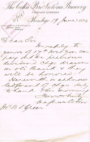 Bendigo Historical Society Inc.
Document - COHN BROTHERS COLLECTION: HANDWRITTEN LETTER DATED 1893
Folded Cohns Bros printed letterhead document dated 19th June 1893 handwritten message re cheques drawn on old bank acc will be honoured. Signed Magnus Cohn. The paper also has a Water Mark, Piries Real Vellum Air Dried.bendigo, industry, cohn bros brewery -
Bendigo Historical Society Inc.
Map - PANNOOBAMAWM : COUNTY OF BENDIGO, 1957
Map. Pannoobamawm, County of Bendigo. By Appointment W.M. Houston, Government Printer, Melbourne. Drawn and reproduced at the Department of Lands and Survey, Melbourne. Price 2/-.1957. Turrumberry, Terrick Terrick East, Wanurp,Pannoomilloo, Bamawm, Pannoobamawm. (number 2 in map cupboard 1)W.M. Houston, Government Printermap, bendigo, pannoobamawm -
Bendigo Historical Society Inc.
Map - NOLAN, COUNTY OF BENDOGO, 7-5-30
Map, Nolan, County of Bendigo, Egerton; Elmore; Goornong. Campaspe River, Elmore Estate, By Authority: H.J.Green, Government Printer,Melbourne.Price 2/-.Drawn and Reproduced at the Dept. of Lands and Survey,Melbourne,Victoria.7-5-30. (number 1 in map cupboard 1)H.J.Green,Government Printermap, bendigo, nolan -
Bendigo Historical Society Inc.
Map - NERRING : COUNTY OF BENDIGO, August 1952
Map. Nerring, County Of Bendigo. Yarraberb, Neilborough, Huntly, Sandhurst, Leichardt, Marong. Drawn and reproduced at the Department of Lands and Survey, Melbourne,Victoria. August 1952, Price 2/-. By Appointment J.J. Gourley, Government Printer, Melbourne. (number 0 in map cupboard 1)J.J. Gourley,Government Printermap, bendigo, nerring -
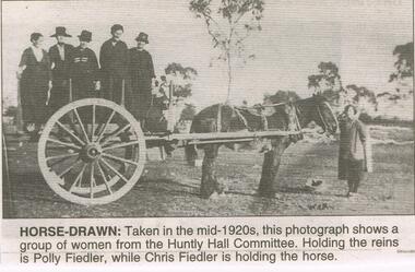 Bendigo Historical Society Inc.
Newspaper - JENNY FOLEY COLLECTION: HORSE DRAWN
Bendigo Advertiser ''The way we were'' from Tuesday, May 24, 2005. Horse drawn: taken in the mid 1920s, this photograph shows a group of women from the Huntly Hall Committee. Holding the reins is Polly Fiedler, while Chris Fiedler is holding the horse.newspaper, bendigo advertiser, the way we were -
 Bendigo Historical Society Inc.
Photograph - HUSTLER'S ROYAL RESERVE GOLD MINE, ROSALIND PARK, BENDIGO
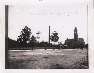
Black and white photo, copy. Image shows poppet head and chimney of Hustler's Royal Reserve Gold Mine, Rosalind Park, Bendigo. Oh RH side, Post Office building with clock tower. Horse drawn vehicles in foreground parked alongside fence.bendigo, mining, hustler's royal reserve mine -
![Wallpaper from 'Reno', St John's Parade [Kew]](/media/collectors/550653872162f11fb04854aa/items/57975996d0cdd1098c81d980/item-media/579759ded0cdd1098c81f6fa/item-fit-380x285.jpg) Kew Historical Society Inc
Kew Historical Society IncDecorative object - Wallpaper sample from 'Reno', St John's Parade, 1890s
Comparatively few weatherboard houses in Kew survived from the early years of settlement into the second half of the 20th century. One such property was ‘Reno’, which once stood on the east side of St John’s Parade. Its earliest recorded owner was the architect Samuel Cocking who lived there from c.1865 until his death in 1888. The original landholding was bordered by Cotham Road, Glenferrie Road, Wellington Street, and Charles Street. The southern portion of this land included a fine orchard, with many imported trees. The old summer house, at first in the orchard, was later removed to the house garden. The MMBW Detail Plan No.1576 (1904) shows the remaining portion of the original land holding, including a semi-circular pathway at the front, and garden features such as an aviary, a fountain and grotto, and a fernery. None of these are apparent in photographs dating from the 1960s, where the garden, which once included rare plants provided by Baron Von Mueller, surrounds the cottage in a tangled frenzy. Despite a ‘local significance’ classification by the National Trust, the house was demolished in 1977. Wallpaper fragment from ‘Reno’. This small fragment of floral wall paper is a bolder design than the delicately drawn flowers in 1977.0005.1. The flowers in this example were impressionistically created using printing blocks that allowed for different thicknesses of paint to be applied in the hand-blocking process. wallpaper, reno, st john's parade, kew -
 Sunbury Family History and Heritage Society Inc.
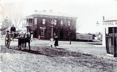
Photograph, Rupertswood Hotel
The photograph was taken at the intersection of Brook and Evans Streets in Sunbury. The two storey bluestone building was the Rupertswood Hotel, which was on the NE corner of the intersection and the single storey Royal Hotel building in the foreground was on the opposite corner. The Millett family originally owned both hotels. The Rupertswood Hotel was demolished in December 1974 to make way for a modern retail store. In 1939 the old Royal Hotel building was damaged by fire and replaced with a two storey red brick building.The Rupertswood and Royal Hotels were two of the earliest hotels to be erected in the Sunbury township.A non-digital black and white photograph of a street photograph featuring an intersection with a two storey bluestone building on one corner and a partial view of a single storey rendered building on the opposite corner. Two children are standing on the side of the road and a man is in a horse-drawn jinker. george millett, royal hotel, rupertswood hotel, evans street, brook street, hotels -
University of Melbourne, Burnley Campus Archives
Work on paper (item) - Student Work, Jo Ferguson, Landscape Construction Portfolio, 2016
Submitted as an assignment in 2016 for HORT90035, a subject run at Burnley Horticultural College and coordinated by Andrew Laidlaw. andrew laidlaw, assignment, burnley horticultural college, hort90035, jo ferguson -
 City of Greater Bendigo - Civic Collection
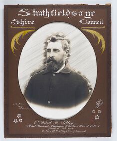
Photograph - Portrait of Councillor Sibley, W H Robinson
The district of Strathfieldsaye was proclaimed in 1861 and named a Shire on the 17th September in 1866. It remained a shire until amalgamation in 1994 when it became part of the City of Greater Bendigo. The shire was located 8 km to the south- east of Bendigo and covered an area of 601 square kilometres and extended from the Calder Highway to the Coliban and Campaspe Rivers. The shire's administration centre was in Strathfieldsaye until 1972 when new offices were opened in KenningtonFramed black and white head and shoulder portrait of Councillor Sibley with hand coloured and drawn detail. Profile slightly to left with walrus moustache and beard. Cut oval brown mount decorated with text, flowers and scrolls. Hand written title top and lower centre.Strathfieldsaye / Shire Council / W m Robinson / Photo / Bendigo / J N B Gribble / Cr Robert R Sibley / First President Chairman of the Road Board 1865 - 5 / President 1866 - 1869 / With Mrs Sibley's Complimentsstrathfieldsaye shire council, councillor sibley, president of strathfieldsaye shire -
 Bendigo Historical Society Inc.
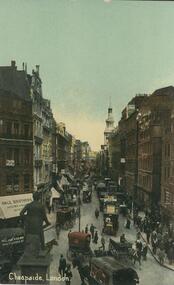
Postcard - Alice McGregor Postcard Collection, 1900 - 1920
Alice McGREGOR Born: 1908; unknown parents. Possibly adopted by the Salter family? Electoral Roll 1936: Highland Terrace Kangaroo Flat. Alice Mary Salter and William Robert Salter living together; presumed to be sister and brother. William Robert Salter was killed in a MVA in Bendigo in 1937 aged 26. In Victoria in 1938, Alice Mary Salter married James Thomas McGregor (born Victoria 1917, died Victoria 1983, buried Fawkner Cemetery) Lived: 1968; 22 Wade Street Golden Square Alice McGregor Died: 1999 aged 91 at Anne Caudle Centre, Bendigo Buried: Kangaroo Flat Cemetery See additional research. Postcard Album of Alice McGregor contained 86 post cards.Postcard Album of Alice McGregor containing 86 postcards. See 1400 Coloured photo of Cheapside, London. View looking down a busy street with horse drawn carriages, motor vehicles. Many pedestrians on footpath and street. Statue on a plinth facing down the street. Rear is blank except for the date in pencil at top left. Jan 12th, 1918 postcard, collector, alice mcgregor -
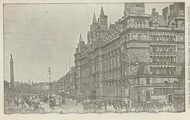 Bendigo Historical Society Inc.
Postcard - Alice McGregor Postcard Collection, 1900 - 1920
Alice McGREGOR Born: 1908; unknown parents. Possibly adopted by the Salter family? Electoral Roll 1936: Highland Terrace Kangaroo Flat. Alice Mary Salter and William Robert Salter living together; presumed to be sister and brother. William Robert Salter was killed in a MVA in Bendigo in 1937 aged 26. In Victoria in 1938, Alice Mary Salter married James Thomas McGregor (born Victoria 1917, died Victoria 1983, buried Fawkner Cemetery) Lived: 1968; 22 Wade Street Golden Square Alice McGregor Died: 1999 aged 91 at Anne Caudle Centre, Bendigo Buried: Kangaroo Flat Cemetery See additional research. Postcard Album of Alice McGregor contained 86 post cards.Postcard Album of Alice McGregor containing 86 postcards. See 1400 B&W photo of the London & North Western Hotel, Lime Street Station, Liverpool. A multi-story building overlooking a statue atop a column. Horse drawn vehicles and pedestrians in the street. Addressee - Miss Kelly, Norwood, Wills St, Bendigo, Australia Sender - M.I. Grendell (?) Dated 25 5.06, Liverpool postcard, collector, alice mcgregor -
 National Vietnam Veterans Museum (NVVM)
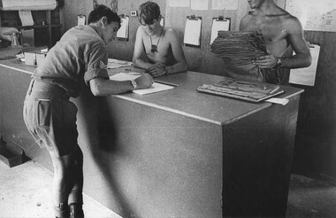
Photograph, Gibbons, Denis, Quartermasters Store 2
Denis Gibbons (1937 – 2011) Trained with the Australian Army, before travelling to Vietnam in January 1966, Denis stayed with the 1st Australian Task Force in Nui Dat working as a photographer. For almost five years Gibbons toured with nine Australian infantry battalions, posting compelling war images from within many combat zones before being flown out in late November 1970 after sustaining injuries. The images held within the National Vietnam Veterans Museum make up the Gibbons Collection. A black and white photograph of at the counter of the 1st Australian Field Hospital, Vung Tau, South Vietnam, Quartermasters Store, two Q Store staff look on as a Sergeant signs for stores drawn on requisition. In the hospital the store held goods and equipment to cover all requirements.photograph, 1st australian field hospital, quartermasters store, vung tau, gibbons collection catalogue, denis gibbons -
 Bendigo Historical Society Inc.
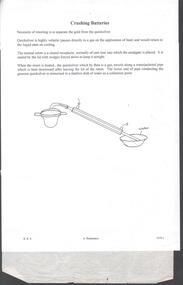
Document - STATE CRUSHING BATTERY - NOTES ON THE STATE CRUSHING BATTERY
Handwritten notes on how the State Crushing Battery works. Also mentioned is how the gold is separated from quicksilver. There are also two pencil drawn illustrations - one of shaking or Wilfley Table and the other separating the gold from the quicksilver. Notes prepared by Albert Richardson.document, gold, state crushing battery, state crushing battery, notes on the state crushing battery, wilfley tables, amalgam, quicksilver, bert tyrrill -
 Bendigo Historical Society Inc.
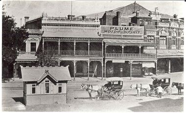
Photograph - BASIL MILLER COLLECTION: HORSEDRAWN CARRIAGES AT CHARRING CROSS
BHS CollectionBlack and white photographic copy, 2 Horsedrawn carriages at tram stop at Charring Cross. Lyric theatre shown top right. Original taken after 1913. Two horse drawn cabs with attendants. Small building. Advertising in background plume Motor Spirit.person, individual, basil miller -
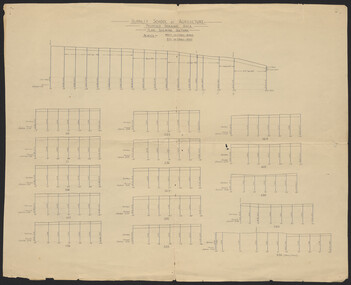 University of Melbourne, Burnley Campus Archives
Plan, Burnley School of Agriculture Proposed Drainage Area Plan Shewing (sic) Sections, 1930
From A.W Jessep file "Improvements (Completed)"Hand drawn. (1) Includes Memorandum dated 25.7.30 to the Agricultural Superintendent from the Principal. (2) Levels over Proposed Drainage Area. From A.W. Jessep file, "Improvements (Completed)." Additional memorandum from the Agricultural Superintendent to Principal (1 folio page)burnley school of agriculture, drainage, drainage pipes