Showing 3212 items
matching road maps
-
![7 Roomed Brick [villa]; Modern Conveniences](/media/collectors/550653872162f11fb04854aa/items/59ec3da221ea690fdc4ba793/item-media/59ec3ee521ea690fdc4d0c37/item-fit-380x285.jpg) Kew Historical Society Inc
Kew Historical Society IncPhotograph - 7 Roomed Brick [villa]; Modern Conveniences, 1920s
The Kew Historical Society's map collection includes a substantial number of real estate subdivision plans, mainly of Kew but also of surrounding suburbs in Melbourne. Most of the subdivision plans date from the 1920s and 1930s when the districts old homes and local farmland were being split up to accommodate residential growth in the postwar period. These early plans were assembled by a local firm, Jas R Mather & McMillan, which had an office in Cotham Road. Many of the plans, and sometimes photos, were annotated by the agents.Subdivision plans are historically important documents used as evidence for the growth of suburbs in Australia. They frequently provide information about when the land was sold as well as evidence relating to surveyors and real estate and financial agents. The numerous subdivision plans in the Kew Historical Society's collection represent working documents, ranging from the initial sketches made in planning a subdivision to printed plans on which auctioneers or agents listed the prices for which individual lots were sold. In a number of cases, the reverse of a subdivision plan in the collection includes a photograph of a house that was also for sale by the agent. These photographs provide significant heritage information relating house design and decoration, fencing and household gardens.The photograph may also be aesthetically significant depending on the importance of the photographic atelier.A professionally produced photograph for a local real estate agent, probably Jas. R. Mathers, Son & McMillan. The photograph is of a Federation-era bungalow, in Kew. The photo is on the reverse of a subdivision plan for the Normanby Heights Estate, Kew.The mount on which the photograph is placed includes: "Kew. 1 minute to tram. Good Position. / 7 roomed brick. Modern conveniences. / Land 60 x 135. 1100 pounds"real estate photographs, houses - kew, federation architecture -
 Kew Historical Society Inc
Plan - Subdivision Plan, Balwyn Theatre and Shop Sites, circa 1927-28, c.1927-28
The Kew Historical Society's map collection includes a substantial number of real estate subdivision plans, mainly of Kew but also of surrounding suburbs in Melbourne. Most of the subdivision plans date from the 1920s and 1930s when the districts old homes and local farmland were being split up to accommodate residential growth in the postwar period. These early plans were assembled by a local firm, Jas R Mather & McMillan, which had an office in Cotham Road. Many of the plans, and sometimes photos, were annotated by the agents. The ‘new’ Balwyn Picture Theatre was built and owned by Balwyn Theatres Pty Ltd in ca. 1928. By 1930, this first Balwyn Theatre was destroyed by fire after a break-in. Following the fire, a new cinema was constructed. This plan for a Cinema and eleven shops presumably dates from 1927/28 when the Company announced that this location in Whitehorse Road ‘was the most central and best suited [area] for their Theatre and shops’.Subdivision plans are historically important documents used as evidence for the growth of suburbs in Australia. They frequently provide information about when the land was sold as well as evidence relating to surveyors and real estate and financial agents. The numerous subdivision plans in the Kew Historical Society's collection represent working documents, ranging from the initial sketches made in planning a subdivision to printed plans on which auctioneers or agents listed the prices for which individual lots were sold. In a number of cases, the reverse of a subdivision plan in the collection includes a photograph of a house that was also for sale by the agent. These photographs provide significant heritage information relating house design and decoration, fencing and household gardens.The photograph may also be aesthetically significant depending on the importance of the photographic atelier.Subdivision plan showing the Balwyn Theatre and its adjoining shop sites in Whitehorse Road Balwyn. The 11 shop sites were noted for their depth (133 ft - 145 ft. [Map.0041]balwyn theatre -- balwyn (vic.), subdivisions -- balwyn (vic), subdivision plans -
 Kew Historical Society Inc
Plan - Subdivision Plan, Argyle Road, Heather Grove, Victor Avenue, Kew, c.1937
... as MAP.0059] Argyle Road, Heather Grove, Victor Avenue, Kew Plan ...The Kew Historical Society's map collection includes a substantial number of real estate subdivision plans, mainly of Kew but also of surrounding suburbs in Melbourne. Most of the subdivision plans date from the 1920s and 1930s when the districts old homes and local farmland were being split up to accommodate residential growth in the postwar period. These early plans were assembled by a local firm, Jas R Mather & McMillan, which had an office in Cotham Road. Many of the plans, and sometimes photos, were annotated by the agents.Subdivision plans are historically important documents used as evidence for the growth of suburbs in Australia. They frequently provide information about when the land was sold as well as evidence relating to surveyors and real estate and financial agents. The numerous subdivision plans in the Kew Historical Society's collection represent working documents, ranging from the initial sketches made in planning a subdivision to printed plans on which auctioneers or agents listed the prices for which individual lots were sold. In a number of cases, the reverse of a subdivision plan in the collection includes a photograph of a house that was also for sale by the agent. These photographs provide significant heritage information relating house design and decoration, fencing and household gardens.The photograph may also be aesthetically significant depending on the importance of the photographic atelier.Undated blue subdivision plan in Kew of 14 lots facing Argyle Road, Heather Grove and Victor Road. The Plan identifies Tuxen & Miller as the surveyors. [Formerly catalogued as MAP.0059]subdivision plans - kew, argyle road - kew, heather grove - kew, victor avenue - kew -
 Kew Historical Society Inc
Document - Urban Planning Document, City of Kew, City of Kew : Minimum Size of Allotment Required, 1945-1955
A document outlining the relevant by-laws produced by the City Of Kew to regulate the minimum size of allotments in Barkers Road, Burke Road, Cotham Road, Glenferrie Road and Studley Park Road, as well as in other streets more generally. The by-laws specify the size of allotments in which single unit dwellings, attached houses and maisonettes, and flats could be built. In the ‘main streets’ a minimum land area for single unit dwellings was 8,100 square feet, with an average frontage of 60’ and a depth of 135’. In other streets this was reduced to an overall size of 6,250 square feet, with an average dimensions of 50’ x 125’. In specifying the land area required by flats, different sizes were regulated for the construction of between two and six flats. Six flats at the time when the regulations were passed must have been the upper limit permitted. Understanding the size of land listed in imperial measurements can be a challenge. Within Australia, the so-called quarter acre block was approximately 11,000 square feet. Those specified in the by-laws would appear to be smaller. The document was pasted on the reverse of a subdivision plan in the collection.This is a rare (undated) document produced by the City of Kew defining how subdivision within the municipality should occur. The document was created to constrain unbridled speculation in subdivisions in the various parts of Kew and East Kew.Undated typed document, issued by the City of Kew (1921-1994) indicating the minimum size of allotment required in Barkers Road, Burke Road, Cotham Road, Glenferrie Road and Studley Park Road. The document is mounted on board and waterstained. It was presumably used by a real estate agent. [Formerly catalogued as MAP.0066].city of kew - by-laws and regulations, subdivisions - kew - studley park -
 Kew Historical Society Inc
Archive (Sub-series) - Subject File, Kew Heritage Review, Residential Places Graded B, Volume 1, 1999, 1999
Graeme Butler & AssociatesProject FilesProvenance OrderBlack 4-Ring binder that includes research about, and an assessment of buildings previously graded B in the City of Kew Urban Conservation Study 1988 by Pru Sanderson Design Pty Ltd. The files were created by the heritage architect Graeme Butler and the paper files include maps, correspondence, title searches, readings, reviews of prior classifications, newspaper and journal articles, directories etc for each property assessed.graeme butler, heritage reviews - kew, 20 yarra street, 8 yarra street, 33 wills street, 25 wellington street, 11 wellington street, 118 walpole street, 84 walpole street, 83 walpole street, 63 walpole street, 52 walpole street, 51 walpole street, 14 vista avenue, 12 tara avenue, 89 studley park road, 75 studley park road, 44 studley park road, 25 studley park road, 13 studley avenue, 21 stoke avenue, 71 stevenson street, 34 stevenson street, 12 stevenson street, 36 stawell street, 11 second avenue, 3 second avenue, 2 second avenue, 34 rowland street, 21 redmond street, 11 redmond street, 16 queen street, 27 princess street, 82 molesworth street, 28 miller grove, 26 miller grove, 24 miller grove, 24 milfay avenue, 8 milfay avenue, 4 merrion grove, 25 mary street, 24 lister avenue, 2 john street, 9 hume street, 7 hume street, 24 howard street, 20 howard street, 19 howard street, 10 howard street, 2 howard street, 26 holroyd street, 12 holroyd street, 73 high street, 69 high street, 35 high street, 6 high street, 53 harp road, 6 gellibrand street, 48 foley street, 9 eglinton street, 25-27 edgecombe street, 21-23 edgecombe street, 5-7 edgecombe street, 23 dunlop avenue, 167 derby street, 8 denmark street, 1 denmark street, 2 daracomb avenue, 2 danielle place, 340 cotham road, 294 cotham road, 241 cotham road, 221-229 cotham road, 208 cotham road, 193 cotham road, 180 cotham road, 171 cotham road, 167 cotham road, 161 cotham road, 135-137 cotham road, 46 clyde street, 4 cameron court, 1291 burke road, 1223 burke road, 1205 burke road, 5 bowen street, 35-37 belford road, 389 barkers road, 387 barkers road, 311 barkers road, 231 barkers road, 83-85 barkers road, 15 adeney avenue, 6 a'beckett streetgraeme butler, heritage reviews - kew, 20 yarra street, 8 yarra street, 33 wills street, 25 wellington street, 11 wellington street, 118 walpole street, 84 walpole street, 83 walpole street, 63 walpole street, 52 walpole street, 51 walpole street, 14 vista avenue, 12 tara avenue, 89 studley park road, 75 studley park road, 44 studley park road, 25 studley park road, 13 studley avenue, 21 stoke avenue, 71 stevenson street, 34 stevenson street, 12 stevenson street, 36 stawell street, 11 second avenue, 3 second avenue, 2 second avenue, 34 rowland street, 21 redmond street, 11 redmond street, 16 queen street, 27 princess street, 82 molesworth street, 28 miller grove, 26 miller grove, 24 miller grove, 24 milfay avenue, 8 milfay avenue, 4 merrion grove, 25 mary street, 24 lister avenue, 2 john street, 9 hume street, 7 hume street, 24 howard street, 20 howard street, 19 howard street, 10 howard street, 2 howard street, 26 holroyd street, 12 holroyd street, 73 high street, 69 high street, 35 high street, 6 high street, 53 harp road, 6 gellibrand street, 48 foley street, 9 eglinton street, 25-27 edgecombe street, 21-23 edgecombe street, 5-7 edgecombe street, 23 dunlop avenue, 167 derby street, 8 denmark street, 1 denmark street, 2 daracomb avenue, 2 danielle place, 340 cotham road, 294 cotham road, 241 cotham road, 221-229 cotham road, 208 cotham road, 193 cotham road, 180 cotham road, 171 cotham road, 167 cotham road, 161 cotham road, 135-137 cotham road, 46 clyde street, 4 cameron court, 1291 burke road, 1223 burke road, 1205 burke road, 5 bowen street, 35-37 belford road, 389 barkers road, 387 barkers road, 311 barkers road, 231 barkers road, 83-85 barkers road, 15 adeney avenue, 6 a'beckett street -
 Kew Historical Society Inc
Archive (Sub-series) - Subject File, Kew Heritage Review, Residential Places Graded B, Volume 2, 1999, 1999
Graeme Butler & AssociatesProject FilesProvenance OrderBlack 4-Ring binder that includes research about, and an assessment of buildings previously graded B in the City of Kew Urban Conservation Study 1988 by Pru Sanderson Design Pty Ltd. The files were created by the heritage architect Graeme Butler and the paper files include maps, correspondence, title searches, readings, reviews of prior classifications, newspaper and journal articles, directories etc for each property assessed. graeme butler, heritage reviews - kew, 25 mary street, 4 merrion grove, 24 milfay avenue, 24 miller grove, 26 miller grove, 28 miller grove, 82 molesworth street, 27 princess street, 16 queen street, 20 yarra street, 84 walpole street, 118 walpole street, 11 wellington street, 83 walpole street, 25 wellington street, 8 yarra street, 33 wills street, 63 walpole street, 14 vista avenue, 89 studley park road, 12 tara avenue, 75 studley park road, 21 redmond street, 52 walpole street, 51 walpole street, 71 stevenson street, 34 rowland street, 21 stoke avenue, 34 stevenson street, 44 studley park road, 25 studley park road, 13 studley avenue, 2 second avenue, 11 second avenue, 3 second avenue, 36 stawell street, 12 stevenson streetgraeme butler, heritage reviews - kew, 25 mary street, 4 merrion grove, 24 milfay avenue, 24 miller grove, 26 miller grove, 28 miller grove, 82 molesworth street, 27 princess street, 16 queen street, 20 yarra street, 84 walpole street, 118 walpole street, 11 wellington street, 83 walpole street, 25 wellington street, 8 yarra street, 33 wills street, 63 walpole street, 14 vista avenue, 89 studley park road, 12 tara avenue, 75 studley park road, 21 redmond street, 52 walpole street, 51 walpole street, 71 stevenson street, 34 rowland street, 21 stoke avenue, 34 stevenson street, 44 studley park road, 25 studley park road, 13 studley avenue, 2 second avenue, 11 second avenue, 3 second avenue, 36 stawell street, 12 stevenson street -
 Kew Historical Society Inc
Archive (Sub-series) - Subject File, Kew Heritage Review, Residential Places Graded B, Volume 3, 1999, 1999
Graeme Butler & AssociatesProject FilesProvenance OrderBlack 4-Ring binder that includes research about, and an assessment of buildings previously graded B in the City of Kew Urban Conservation Study 1988 by Pru Sanderson Design Pty Ltd. The files were created by the heritage architect Graeme Butler and the paper files include maps, correspondence, title searches, readings, reviews of prior classifications, newspaper and journal articles, directories etc for each property assessed.graeme butler, heritage reviews - kew, 4 cameron court, 2 hodgson street, 20 fellows street, 26 fellows street, 23 highbury grove, kew lunatic asylum, kew mental hospital, willsmere, 36 stawell street, 13 studley avenue, 16 studley avenue, 20 studley avenue, raheen, studley park road, beament house, 33 uvadale road, 20 yarra streetgraeme butler, heritage reviews - kew, 4 cameron court, 2 hodgson street, 20 fellows street, 26 fellows street, 23 highbury grove, kew lunatic asylum, kew mental hospital, willsmere, 36 stawell street, 13 studley avenue, 16 studley avenue, 20 studley avenue, raheen, studley park road, beament house, 33 uvadale road, 20 yarra street -
 Kew Historical Society Inc
Archive (Sub-series) - Subject File, Bridges (Kew), 1958-present
Various partiesReference, Research, InformationSecondary Values (KHS Imposed Order)Subject file containing information relating to each of the bridges crossing the Yarra In Kew. The file includes correspondence, photocopied photographs and maps, journal articles, research, and printed ephemera. Bridges referred to and described in the file include Kanes Bridge, Walmer Street Foot Bridge, Johnston Street Bridge, Chandler Bridge, Collins Bridge, Tramway or Zig Zag Bridge, Penny Toll Bridge, Victoria Street Bridge, Burke Road Bridge. The file includes original materials relating to the Victoria Street Bridge Centenary Celebration 1884-1984 -
 Kew Historical Society Inc
Map, Real Estate Map of Bulleen, Templestowe, Lower Templestowe, Doncaster, North Balwyn
A large undated printed map of Bulleen, Templestowe, Lower Templestowe, Doncaster, North Balwyn showing major and minor roads, waterways and proposed facilities in this area of Melbourne.A useful if undated real estate map that allows viewers to compare current and historic aspects of these areasMap of Bulleen, Templestowe, Lower Templestowe, Doncaster, North Balwyn used by JB Thomson & Co, Real Estate Agents, to identify and record land sales on these. There are some markings on the plan indicating the location and price of lots.subdivision plans, bulleen, templestowe, lower templestowe, doncaster, north balwyn -
 Kew Historical Society Inc
Plan - Subdivision Plan, Riverside Estate, Camberwell North (Balwyn), 1938, 1939
This subdivision known as the Riverside Estate wa sone of the largest and most significant in Balwyn's history.Subdivision Plan for 41 lots within the wider Riverside Estate in Camberwell North, now Balwyn, in February 1938. The auction featured lots in Burke Road, The Boulevard, Mt View Road, Wattle Avenue, Kyora Parade, Cascade Street, Riverside Avenue, Walbundry Avenue, Inverness Way, Bulleen Road and Doncaster Road.Allotments for sale are shaded grey on the map. Certain lots have an H in a circle. These are presumably where houses had already been constructed.subdivision plans - balwyn (vic), riverside estate - balwyn (vic) -
Kew Historical Society Inc
Book, Allen & Unwin, At The End Of The Road : Government, society and the disposal of human remains in the nineteenth and twentieth centuries, 1994
xvi, 464 p., [4] leaves of plates : ill. (some col.), plans, ports. ; 24 cm. non-fictioncemeteries -- south australia -- history, funeral rites and ceremonies -- south australia -- history, burial laws -- south australia, cremation -- south australia -- history -
 Kew Historical Society Inc
Work on paper - Sepia Wash & Ink, G B Richardson, Creek and Old Watering Stage, on the Yarra, East Collingwood, 1854, 1854
Blind Creek was located between the Abbotsford Convent and what is now the Collins Bridge in Studley Park. In an 1858 map of East Collingwood by Clement Hodgkinson, in the State Library of Victoria, one can see how the creek was originally a significant landmark in Collingwood; remaining vacant land until a barrel drain enclosed it. The area was later filled in, surveyed and developed. The position where Blind Creek entered the Yarra was in the immediate vicinity of Hodgson’s Punt, which had linked Kew to the other side of the Yarra from 1839. The Punt was purchased by the Colonial Government in 1852 and was in use until the opening of the Studley Park Road (Johnston Street) Bridge in 1858 made its continued use redundantThe point of view selected by the artist for the watercolour is from the banks of Blind Creek in East Collingwood, looking across the Yarra to the Kew side of the river.Inscribed verso 'Creek and Old Watering stage, on the Yarra East Collingwood 1854 / Trees, stage, &c have long since disappeared / [Artist Signature] / FT 110 / Creek itself now being filled in 1903.gb richardson, blind creek - abbotsford, yarra river - abbotsford (vic) - kew (vic), colonial artists, australian art - 19th century, george bouchier richardson -
 Kew Historical Society Inc
Photograph - 'Raheen', Studley Park Road (Kew), c.1965
"The first section of Raheen was commenced in 1870 with an extension added in 1884. It was designed by William Salway and built for Edward Latham of the Carlton Brewery. Sir Henry Wrixon, prominent Melbourne barrister and solicitor, later owned and resided at the property. In 1917 Raheen was purchased by the Catholic Church and became the official residence of Archbishop Mannix, as well as four other Catholic archbishops of Melbourne. In 1981 the Church sold the property and it again reverted to a private residence." (Victorian Heritage Database, 2023)This work forms part of the collection assembled by the historian Dorothy Rogers (1905-1973), donated to the Kew Historical Society by her son in 2015. The manuscripts, photographs, maps, and documents were sourced by her from both family and local collections or produced as references for her print publications. Many were directly used by Rogers in writing ‘Lovely Old Homes of Kew’ (1961) and 'A History of Kew' (1973), or the numerous articles on local history that she produced for suburban newspapers. Most of the photographs in the collection include detailed annotations in her hand. The Rogers Collection provides a comprehensive insight into the working habits of a historian from the 1960s to the 1970s. Original, monochrome print copy of a photograph of Raheen in Studley Park Road (Kew). The unrendered red brick house with tower has a toe story section at right with a double colonnade and a single story section at left. The photographs predates the restoration of the gardens and house by te. Pratt family. Annotation verso: "Raheen. R. C. Archbishops Palace, Studley Park Road, Kew".reheen, mansions -- kew (vic.), studley park road -
!['Reno', St John's Parade [Kew]](/media/collectors/550653872162f11fb04854aa/items/658d16120f23e8f1e738df53/item-media/658d16680f23e8f1e738e098/item-fit-380x285.jpg) Kew Historical Society Inc
Kew Historical Society IncPhotograph - 'Reno', St John's Parade [Kew], c. 1965
‘Reno’, stood on the east side of St John’s Parade. Its earliest recorded owner was the architect Samuel Cocking who lived there from c.1865 until his death in 1888. The original landholding was bordered by Cotham Road, Glenferrie Road, Wellington Street, and Charles Street. The garden including rare plants supplied by Baron Von Mueller, surrounds the cottage in a tangled frenzy. Despite a ‘local significance’ classification by the National Trust, the house was demolished in 1977.This work forms part of the collection assembled by the historian Dorothy Rogers (1905-1973), donated to the Kew Historical Society by her son in 2015. The manuscripts, photographs, maps, and documents were sourced by her from both family and local collections or produced as references for her print publications. Many were directly used by Rogers in writing ‘Lovely Old Homes of Kew’ (1961) and 'A History of Kew' (1973), or the numerous articles on local history that she produced for suburban newspapers. Most of the photographs in the collection include detailed annotations in her hand. The Rogers Collection provides a comprehensive insight into the working habits of a historian from the 1960s to the 1970s. Original monochrome photograph of Reno, St John's Parade, Kew. Pictured are the garage in the distance at left, the weatherboard house with its simple verandah, and the overgrown front garden.Annotation verso: "Reno. St Johns Parade. Reno. Miss Green".dorothy rogers, reno.-- st john's parade (kew) -
!['Ross House', Cotham Road [Kew]](/media/collectors/550653872162f11fb04854aa/items/658f6ccb9239cf6fd436923e/item-media/658f6ce39239cf6fd43692f3/item-fit-380x285.jpg) Kew Historical Society Inc
Kew Historical Society IncPhotograph - 'Ross House', Cotham Road [Kew], c.1960
Ross House, formerly called Charleville, was built as a two-storey mansion in 1889 for Charles Donaldson. It was designed in the Italianate style by the architect H. Shallers and built by G. Ginham. Dr Tom King, surgeon purchased Charleville from Donaldson in 1939 and renamed it Ross House. This work forms part of the collection assembled by the historian Dorothy Rogers (1905-1973), donated to the Kew Historical Society by her son in 2015. The manuscripts, photographs, maps, and documents were sourced by her from both family and local collections or produced as references for her print publications. Many were directly used by Rogers in writing ‘Lovely Old Homes of Kew’ (1961) and 'A History of Kew' (1973), or the numerous articles on local history that she produced for suburban newspapers. Most of the photographs in the collection include detailed annotations in her hand. The Rogers Collection provides a comprehensive insight into the working habits of a historian from the 1960s to the 1970s.Facade of 'Ross House' (formerly 'Charleville') in Cotham Road, Kew. Inscription verso: "Ross House , Bib Stillwell, Cotham Rd".ross house, charleville, cotham road, kew, dorothy rogers, charles donaldson, tom king, g. ginham, h. shallers -
!['Ross House', Cotham Road [Kew]](/media/collectors/550653872162f11fb04854aa/items/658f7f779239cf6fd436d4e6/item-media/658f7f919239cf6fd436d586/item-fit-380x285.jpg) Kew Historical Society Inc
Kew Historical Society IncPhotograph - 'Ross House', Cotham Road [Kew], c.1960
Ross House, formerly called Charleville, was built as a two-storey mansion in 1889 for Charles Donaldson. It was designed in the Italianate style by the architect H. Shallers and built by G. Ginham. Dr Tom King, surgeon purchased Charleville from Donaldson in 1939 and renamed it Ross House. This work forms part of the collection assembled by the historian Dorothy Rogers (1905-1973), donated to the Kew Historical Society by her son in 2015. The manuscripts, photographs, maps, and documents were sourced by her from both family and local collections or produced as references for her print publications. Many were directly used by Rogers in writing ‘Lovely Old Homes of Kew’ (1961) and 'A History of Kew' (1973), or the numerous articles on local history that she produced for suburban newspapers. Most of the photographs in the collection include detailed annotations in her hand. The Rogers Collection provides a comprehensive insight into the working habits of a historian from the 1960s to the 1970s.Facade of 'Ross House' (formerly 'Charleville') in Cotham Road, Kew. Inscription verso: "Ross House, Bib Stillwell, Cotham Rd."ross house, charleville, cotham road, kew, dorothy rogers, charles donaldson, tom king, g. ginham, h. shallers -
 Kew Historical Society Inc
Photograph, Walsh grave, Boroondara General Cemetery, circa 1965, c. 1965
Dr William Butler Walsh was born in 1854. He bought from James Venn Morgan on the corner of Charles Street and Cotham Road and in 1886 built Wilton on this site. He was at one stage the only doctor between Melbourne and Lilydale.This work forms part of the collection assembled by the historian Dorothy Rogers, that was donated to the Kew Historical Society by her son John Rogers in 2015. The manuscripts, photographs, maps, and documents were sourced by her from both family and local collections or produced as references for her print publications. Many were directly used by Rogers in writing ‘Lovely Old Homes of Kew’ (1961) and 'A History of Kew' (1973), or the numerous articles on local history that she produced for suburban newspapers. Most of the photographs in the collection include detailed annotations in her hand. The Rogers Collection provides a comprehensive insight into the working habits of a historian in the 1960s and 1970s. Together it forms the largest privately-donated collection within the archives of the Kew Historical Society.Grave of the Walsh family in the Boroondara General Cemeterywilliam butler walsh, boroondara general cemetery, dorothy rogers, kew cemetery -
 Kew Historical Society Inc
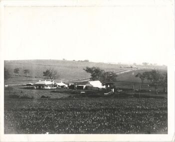
Photograph, Kilby Farm, Kew East, Before 1920
Kilby Lodge (c.1845-c.1922). William Oswin purchased Crown Land Lots 52 & 53 in 1845. These lots ran north from an old bullock track [later Kilby Road] to the Yarra, and east to Burke Road. Oswin purchased a neighbouring Lot in 1851, separated by the bullock track from the rest of the farm. Oswin built ‘Kilby Lodge’ and, with his brother, farmed dairy cattle on the site. Oswin’s descendants owned the farm into the 1890s. New subdivisions of Kilby and neighbouring farms in the 1920s changed the rural nature of north Kew. Housing and large recreation reserves replaced dairy farms and market gardens. This work forms part of the collection assembled by the historian Dorothy Rogers, that was donated to the Kew Historical Society by her son John Rogers in 2015. The manuscripts, photographs, maps, and documents were sourced by her from both family and local collections or produced as references for her print publications. Many were directly used by Rogers in writing ‘Lovely Old Homes of Kew’ (1961) and 'A History of Kew' (1973), or the numerous articles on local history that she produced for suburban newspapers. Most of the photographs in the collection include detailed annotations in her hand. The Rogers Collection provides a comprehensive insight into the working habits of a historian in the 1960s and 1970s. Together it forms the largest privately-donated collection within the archives of the Kew Historical Society.A panoramic photograph of Kilby (or Oswin's) Farm in East Kew."Kilby Farm when Oswins owned it. Commenced 1845."kilby farm, kilby lodge, william oswin, dorothy rogers, kew east -
 Kew Historical Society Inc
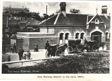
Print, Kew Railway Station in the early 1900s, c.1900
Kew Railway Station (1887-1959). ‘Kew Railway Station’ in Denmark Street was the terminus of the Kew Line, which extended from Hawthorn Station to just south of Wellington Street. The Station opened on 19 December 1887 after a prolonged campaign for a railway by the people of Kew. Due to a decline in patronage, the passenger service ceased operations in August 1952. While a freight service continued for another five years, the line and station were officially closed on 13 May 1957. Subsequently demolished in 1959, the headquarters of VicRoads (formerly Country Roads Board) now stands on the former Station site.This work forms part of the collection assembled by the historian Dorothy Rogers, that was donated to the Kew Historical Society by her son John Rogers in 2015. The manuscripts, photographs, maps, and documents were sourced by her from both family and local collections or produced as references for her print publications. Many were directly used by Rogers in writing ‘Lovely Old Homes of Kew’ (1961) and 'A History of Kew' (1973), or the numerous articles on local history that she produced for suburban newspapers. Most of the photographs in the collection include detailed annotations in her hand. The Rogers Collection provides a comprehensive insight into the working habits of a historian in the 1960s and 1970s. Together it forms the largest privately-donated collection within the archives of the Kew Historical Society.A photographic copy of a book plate from 'Kew's Civic Century' (1960) by W.D. Vaughan. The book plate was itself a copy of an early 20th century postcard depicting the Kew Railway Station."Railway opened 1887 - Then as photo states"kew railway station, dorothy rogers, country roads board, vicroads -
 Kew Historical Society Inc
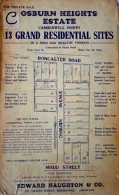
Plan - Subdivision Plan, Osburn Heights Estate, 1938
Edward Haughton & Co, in promoting the Osburn Heights Estate in what is now Balwyn North, attempted to capitalize on the subdivision’s proximity to East Kew. One section of the plan is includes the text: ‘The New Suburb: Camberwell North or East Kew (the names are synonymous)’. The Osburn Heights subdivision was part of a series of subdivisions running between Doncaster Road and Maud Street, including the ‘Pointed Firs Estate’ (MAP.0010). This subdivision included 13 ‘grand residential sites’ for sale in Doncaster Road, Maud Street and Osburn Avenue.subdivision plans - camberwell north, osburn heights estate -
 Kew Historical Society Inc
Plan - Subdivision Plan, Windella-Darnley Subdivision, Studley Park, 1920s
Subdivision plans are historically important documents used as evidence of the growth of suburbs in Australia. They frequently provide information about when the land was sold on which a built structure was subsequently constructed as well as evidence relating to surveyors and real estate and financial agents. The numerous subdivision plans in the Kew Historical Society's collection represent working documents, ranging from the initial sketches made in planning a subdivision to printed plans on which auctioneers or agents listed the prices for which individual lots were sold. In a number of cases, the reverse of a subdivision plan in the collection includes a photograph of a house that was also for sale by the agent. These photographs provide significant heritage information relating house design and decoration, fencing and household gardens.Version 1 of two subdivision plans (the later one is MAP.0027) for the section of Studley Park Road near the Junction on the south side. Named in the subdivision are the mansions of Darley and Windella (now demolished). Before the subdivision of Darley and Windella, both houses fronted Studley Park Road. Both houses appear to be advertised as lots in the subdivision. Bisecting the subdivision is a street, Antrim Avenue that was never constructed. A street, which was subsequently constructed in this vicinity, was Merrion Place, which now runs between Studley Park Road and Highfield Grove. There are 14 proposed lots in this subdivision."Antrim Avenue. See over for new plan"subdivision plans - kew, studley park, windella, darnley, studley park road -- kew (vic.), merrion place -- kew (vic.), merrion grove -- kew (vic.), highbury grove -- kew (vic.) -
 Kew Historical Society Inc
Plan - Subdivision Plan, 6 Choice Residential Allotments: East Kew, 1932
Prue Sanderson, in her groundbreaking ‘City of Kew Urban Conservation Study : Volume 2 - Development History’ (1988), summarised the periods of urban development and subdivisions of land in Kew. The periods that she identified included 1845-1880, 1880-1893, 1893-1921, 1921-1933, 1933-1943, and Post-War Development. These periods were selected as they represented periods of rapid growth or decline in urban development. An obvious starting point for Sanderson’s groupings involved population growth and the associated economic cycles. These cycles also highlighted urban expansion onto land that was predominantly rural, although in other cases it represented the decline and breakup of large estates. A number of the plans in the Kew Historical Society’s collection can also be found in other collections, such as those of the State Library of Victoria and the Boroondara Library Service. A number are however unique to the collection.Subdivision plans are historically important documents used as evidence of the growth of suburbs in Australia. They frequently provide information about when the land was sold on which a built structure was subsequently constructed as well as evidence relating to surveyors and real estate and financial agents. The numerous subdivision plans in the Kew Historical Society's collection represent working documents, ranging from the initial sketches made in planning a subdivision to printed plans on which auctioneers or agents listed the prices for which individual lots were sold. In a number of cases, the reverse of a subdivision plan in the collection includes a photograph of a house that was also for sale by the agent. These photographs provide significant heritage information relating house design and decoration, fencing and household gardens.The mansion Woodlands in Harp Road, East Kew suffered the death of a thousand cuts. In its case, the cuts were subdivisions. Previous subdivisions of the mansion and its grounds were given titles such as ‘The Eastlawn Estate’ (MAP.0055), whereas at the end, the subdivision called it as it was, naming itself the ‘final section of the Woodlands Estate’ when it was put up for auction in 1932. The emphasis in the promotion of the subdivision was that it provided purchasers with splendid opportunities ‘to build modern homes in select, well established modern surroundings’. As with other subdivisions in the interwar period, transport links were emphasised. The six residential lots cut Woodlands off from Harp Road. When the vendor, Louisa Rachel Preston Hill, was to die at Woodlands in 1937 aged 86 her address was given as Normanby Road.subdivision plans - kew, woodlands estate -
 Kew Historical Society Inc
Plan - Subdivision Plan, J R Mathers & McMillan, Glenferrie Road, Cotham Road, Belmont Avenue, Stirling Street, 1910-1930
Pru Sanderson, in her groundbreaking ‘City of Kew Urban Conservation Study : Volume 2 - Development History’ (1988), summarised the periods of urban development and subdivisions of land in Kew. The periods that she identified included 1845-1880, 1880-1893, 1893-1921, 1921-1933, 1933-1943, and Post-War Development. These periods were selected as they represented periods of rapid growth or decline in urban development. An obvious starting point for Sanderson’s groupings involved population growth and the associated economic cycles. These cycles also highlighted urban expansion onto land that was predominantly rural, although in other cases it represented the decline and breakup of large estates. A number of the plans in the Kew Historical Society’s collection can also be found in other collections, such as those of the State Library of Victoria and the Boroondara Library Service. A number are however unique to the collection.The Kew Historical Society collection includes almost 100 subdivision plans pertaining to suburbs of the City of Melbourne. Most of these are of Kew, Kew East or Studley Park, although a smaller number are plans of Camberwell, Deepdene, Balwyn and Hawthorn. It is believed that the majority of the plans were gifted to the Society by persons connected with the real estate firm - J. R. Mathers and McMillan, 136 Cotham Road, Kew. The Plans in the collection are rarely in pristine form, being working plans on which the agent would write notes and record lots sold and the prices of these. The subdivision plans are historically significant examples of the growth of urban Melbourne from the beginning of the 20th Century up until the 1980s. A number of the plans are double-sided and often include a photograph on the reverse. A number of the latter are by noted photographers such as J.E. Barnes.A ‘proposed’ subdivision of the area in the vicinity of Cotham and Glenferrie Roads and Belmont Avenue depicts an alternate vision for how the land might be divided into lots. When comparing this undated proposed subdivision with a modern map, it is possible to see why the subdivision did not eventuate. The right-of-way shown in the plan as beginning in Belmont Avenue was to be extended much further, preventing the lower lots from being created in the proposed shapes. Identifying the date of the name change may assist in the dating of the proposed subdivision. In faded writing at the top of the plan is an annotation referring to ‘Abbotsford’ and Finlayson’s Agency.subdivision plans - kew, glenferrie road, cotham road, belmont avenue, stirling street -
 Kew Historical Society Inc
Plan - Subdivision Plan, Lodged Plan No.6518, 1920-1940
The Kew Historical Society collection includes almost 100 subdivision plans pertaining to suburbs of the City of Melbourne. Most of these are of Kew, Kew East or Studley Park, although a smaller number are plans of Camberwell, Deepdene, Balwyn and Hawthorn. It is believed that the majority of the plans were gifted to the Society by persons connected with the real estate firm - J. R. Mathers and McMillan, 136 Cotham Road, Kew. The Plans in the collection are rarely in pristine form, being working plans on which the agent would write notes and record lots sold and the prices of these. The subdivision plans are historically significant examples of the growth of urban Melbourne from the beginning of the 20th Century up until the 1980s. A number of the plans are double-sided and often include a photograph on the reverse. Reconciling this hand-drawn subdivision plan with a modern map of the area is initially a challenge due to a change of street names. Argyle Road in the centre of the subdivision was to be renamed Deepdene Road, and the street named Deepdene Road on the plan was to become Deepdene Place. Of interest is the nursery on the corner of Argyle and Whitehorse Roads. During this period there were a number of nurseries servicing the Kew and Balwyn areas. The subdivision was essentially of the land formerly occupied by the house 'Deepdene'.subdivision plans - balwyn, deepdene, whitehorse road -- deepdene (vic.), deepdene road -- deepdene (vic.), burke road -- deepdene (vic.) -
 Kew Historical Society Inc
Map - Subdivision Plan, Grenville Estate, 1922
Pru Sanderson, in her groundbreaking ‘City of Kew Urban Conservation Study : Volume 2 - Development History’ (1988), summarised the periods of urban development and subdivisions of land in Kew. The periods that she identified included 1845-1880, 1880-1893, 1893-1921, 1921-1933, 1933-1943, and Post-War Development. These periods were selected as they represented periods of rapid growth or decline in urban development. An obvious starting point for Sanderson’s groupings involved population growth and the associated economic cycles. These cycles also highlighted urban expansion onto land that was predominantly rural, although in other cases it represented the decline and breakup of large estates. A number of the plans in the Kew Historical Society’s collection can also be found in other collections, such as those of the State Library of Victoria and the Boroondara Library Service. A number are however unique to the collection.Subdivision plans are historically important documents used as evidence of the growth of suburbs in Australia. They frequently provide information about when the land was sold on which a built structure was subsequently constructed as well as evidence relating to surveyors and real estate and financial agents. The numerous subdivision plans in the Kew Historical Society's collection represent working documents, ranging from the initial sketches made in planning a subdivision to printed plans on which auctioneers or agents listed the prices for which individual lots were sold. In a number of cases, the reverse of a subdivision plan in the collection includes a photograph of a house that was also for sale by the agent. These photographs provide significant heritage information relating house design and decoration, fencing and household gardens.In advertising the twenty-two sites of the Grenville Estate in Cotham Road and Alfred Street, Kew, the auctioneers emphasised the proximity of the development to shops, schools, and churches. That mansions surrounded the Estate was publicised as an added attraction. The plan shows how at this stage A regrettable aspect of this plan is that it is pasted over, and obscures a real estate photograph by the Kew photographer Josiah Earl Barnes.subdivision plans - kew, grenville estate, glenferrie road, alfred street, thomas street, cotham road -
 Kew Historical Society Inc
Plan - Subdivision Plan, J R Mathers & McMillan, Clutha Subdivision, 1940
Pru Sanderson, in her groundbreaking ‘City of Kew Urban Conservation Study : Volume 2 - Development History’ (1988), summarised the periods of urban development and subdivisions of land in Kew. The periods that she identified included 1845-1880, 1880-1893, 1893-1921, 1921-1933, 1933-1943, and Post-War Development. These periods were selected as they represented periods of rapid growth or decline in urban development. An obvious starting point for Sanderson’s groupings involved population growth and the associated economic cycles. These cycles also highlighted urban expansion onto land that was predominantly rural, although in other cases it represented the decline and breakup of large estates. A number of the plans in the Kew Historical Society’s collection can also be found in other collections, such as those of the State Library of Victoria and the Boroondara Library Service. A number are however unique to the collection.The Kew Historical Society collection includes almost 100 subdivision plans pertaining to suburbs of the City of Melbourne. Most of these are of Kew, Kew East or Studley Park, although a smaller number are plans of Camberwell, Deepdene, Balwyn and Hawthorn. It is believed that the majority of the plans were gifted to the Society by persons connected with the real estate firm - J. R. Mathers and McMillan, 136 Cotham Road, Kew. The Plans in the collection are rarely in pristine form, being working plans on which the agent would write notes and record lots sold and the prices of these. The subdivision plans are historically significant examples of the growth of urban Melbourne from the beginning of the 20th Century up until the 1980s. A number of the plans are double-sided and often include a photograph on the reverse. A number of the latter are by noted photographers such as J.E. Barnes.The subdivision plan for the Clutha Subdivision is one of the largest in the Society’s collection. The plan includes a map of the proposed allotments, photographic views to the north and south, and information about the kinds of buildings that could be constructed on the allotments. The subdivision was bounded by Studley Park Road, and Carson, Stevenson and Edgecombe Streets. Two new streets, Mackie Court and Younger Street were created as part of the subdivision. The subdivision took its name from ‘Clutha’, the home of John Carson, who was to become Mayor of Kew in 1863. A Report to the City of Boroondara outlined how: ‘The Clutha estate was progressively developed from 1940, with new houses under construction on the Studley Park Road, Carson and Edgecombe Street frontages by 1941. By 1943, directory listings were available for all addresses with the exception of Mackie Court. Building ceased after the government’s prohibition on civilian building was enforced from 1942, with little change in listings until the 1950s when the remainder of the subdivision was developed’."H"subdivisions - kew - studley park, clutha subdivision, studley park road -
 Kew Historical Society Inc
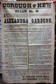
Document, Borough of Kew, Borough of Kew By-Law No.45 : Alexandra Gardens, 1908
The ‘Alexandra Gardens’ in Cotham Road were designed and laid out by George and Thomas Pockett. The Governor of Victoria officially opened them in 1908. A report of the opening stated that “…the gardens have been laid out in large sloping lawns, divided by wide graveled paths, and dotted with tastefully arranged flower beds, which are now bright with autumn bloom”. The massed beds of shrubs and flowers included beds of chrysanthemums, a specialty of George Pockett, the Garden’s first curator. A large rotunda was constructed in 1910 to mark the Jubilee of Kew. A plaque memorialising the contribution of George Pockett, was attached to the original rotunda after his death in 1922. By 1911, electric lighting was installed to allow the public to access the Gardens, and the concerts that were held within them on summer nights. The Gardens were later to include the Jubilee Fountain, moved from the front of the Kew Post Office in 1925. The Kew Council commissioned the substantial bluestone entrance gates in 1933.The Kew Historical Society is fortunate that the City Engineer, Mr Poulter, donated a number of items held by the City of Kew to the Society for safekeeping, rather than identifying them for destruction. The most significant items donated included old maps, including those issued by the Board of Works. Other items included photographs of public works undertaken by the Department. The By-laws are part of that donation and tell us lots about the social values of the period.The Mayor, Councillors and Burgesses of the Borough of Kew published By-Law No.45 in 1908 to regulate the “Conduct of Persons whilst at or Within the Gardens known as the Alexandra Gardens”. The By-Law also set a charge for “Persons Using or Entering in or upon the said Gardens”. The 17 by-laws included predictable prohibitions on expectorating, using indecent language, interfering with the floral displays, or indeed with the caretaker gardeners. Other acts prohibited included a warning that “Children under the age of ten years not being under the control of some competent person may be removed from said gardens”. The Alexandra Gardens were at one stage surrounded by a picket fence. This might explain the prohibition on climbing upon or getting through over or under any fence at or within the gardens. The financial penalty for breaching the By-Law was determined as “…not exceeding Ten pounds and not less than Five shillings”. This original copy of the By-Law was donated to the Kew Historical Society by the City of Kew.alexandra gardens (cotham road, kew), city of kew -
 Kew Historical Society Inc
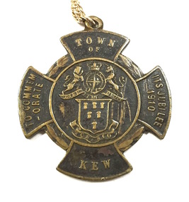
Medal, Stokes & Sons, Town of Kew : To Commemorate its Jubilee, 1910
Medal issued to commemorate the 50th jubilee of the Town of Kew. It names J.F. McCrea as Mayor. John Falding McCrea was Mayor of Kew 1910-11. Kew was proclaimed a municipality on 22 December 1860, seceding from the Boroondara Road Board District, then comprising Kew, Hawthorn and Camberwell. It was proclaimed a town on 8 December 1910, the year this medal was issued, and a city on 10 March 1921. On 22 June 1994 Kew city was united with Camberwell and Hawthorn cities to form Boroondara city. (MV)This work forms part of the collection assembled by the historian Dorothy Rogers, that was donated to the Kew Historical Society by her son John Rogers in 2015. The manuscripts, photographs, maps, and documents were sourced by her from both family and local collections or produced as references for her print publications. Many were directly used by Rogers in writing ‘Lovely Old Homes of Kew’ (1961) and 'A History of Kew' (1973), or the numerous articles on local history that she produced for suburban newspapers. Most of the photographs in the collection include detailed annotations in her hand. The Rogers Collection provides a comprehensive insight into the working habits of a historian in the 1960s and 1970s. Together it forms the largest privately-donated collection within the archives of the Kew Historical Society.Bronze Town of Kew Jubilee medal in the shape of a Maltese Cross.Obverse description Shield of six wheat-sheafs above motto CRESCO on ribbon; above shield is the Royal coat of arms with lion and unicorn supporters and, on ribbon DIEU ET MIN DROIT; on arms of cross top, TOWN / OF, bottom, KEW, left TO COMMEM / -ORATE, right, ITS JUBILEE / 1910 Reverse description shield of six wheat-sheafs above motto CRESCO on ribbon; above shield is the Royal coat of arms with lion and unicorn supporters and, on ribbon DIEU ET MIN DROIT; on arms of cross top, TOWN / OF, bottom, KEW, left TO COMMEM / -ORATE, right, ITS JUBILEE / 1910town of kew jubilee (1910), commemorative medals - kew (vic), australian commemorative medals -
 Kew Historical Society Inc
Plan - Framed Subdivision Plan (copy), F Price, Plan of Mr William Derrick's Land, Kew being Subdivision of Part of Section 86, Parish of Boroondara, County of Bourke, 1872, 1872
William Derrick was an early landowner in Kew, and with James Venn Morgan and James Dannock the purchaser of the parcel of land bounded by Cotham Road, High Street and Mary Street. Derrick Street in Kew is named after him.Map mounted under perspex. ‘Plan of Mr Willia Derrick's Land, Kew being Subdivision of Part of Section 86, Parish of Boroondara, County of Bourke’. This is a copy of the plan held in the State Library of Victoria.kew subdivision plan, john derrick, subdivision plans -- kew (vic.) -
 Kew Historical Society Inc
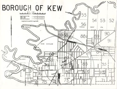
Plan, Borough of Kew, 1910
This work forms part of the collection assembled by the historian Dorothy Rogers, that was donated to the Kew Historical Society by her son John Rogers in 2015. The manuscripts, photographs, maps, and documents were sourced by her from both family and local collections or produced as references for her print publications. Many were directly used by Rogers in writing ‘Lovely Old Homes of Kew’ (1961) and 'A History of Kew' (1973), or the numerous articles on local history that she produced for suburban newspapers. Most of the photographs in the collection include detailed annotations in her hand. The overhead transparency is of a map produced by H.C. Crouch Borough Surveyor in 1910The Rogers Collection provides a comprehensive insight into the working habits of a historian in the 1960s and 1970s. Together it forms the largest privately-donated collection within the archives of the Kew Historical Society.An overhead transparency of a plan of Kew comparing the roads in 1860 with later roads constructed by 1910. Sections of the plan are marked with the location of particular buildings, farms or transport routes.Borough of Kewborough of kew, h.c. crouch