Showing 32050 items matching "buildings"
-
 Bendigo Historical Society Inc.
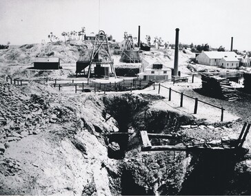
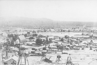
Photograph - VICTORIA HILL, 1860's ?
Black and white photo - mines and mining. At centre front - deep trench. At centre shed, poppet legs, wood pile, building with chimney at right. Wood pile, Building with chimney at back. At back, poppet legs on horizon, trees, building ( house ) buildings with chimney, trees, behind trees large 2 storey building ( Gold Mines Hotel ? ) other large buildings on horizon to right. ' Mining - Bendigo Vic. View of Victoria Hill taken from Old Chum Hill' written on back of photo.place, landscape view, victoria hill -
 Glen Eira Historical Society
Album - Album page, Kambrook Road, Circa 1972
This photograph is part of the Caulfield Historical Album 1972. This album was created in approximately 1972 as part of a project by the Caulfield Historical Society to assist in identifying buildings worthy of preservation. The album is related to a Survey the Caulfield Historical Society developed in collaboration with the National Trust of Australia (Victoria) and Caulfield City Council to identify historic buildings within the City of Caulfield that warranted the protection of a National Trust Classification. Principal photographer thought to be Trevor Hart, member of Caulfield Historical Society. Most photographs were taken between 1966-1972 with a small number of photographs being older and from unknown sources. All photographs are black and white except where stated, with 386 photographs over 198 pages. https://vhd.heritagecouncil.vic.gov.au/places/43737 - re 26 Kambrook Road and 345 Balaclava Road corner building: A prominently situated two-storeyed complex of late Victorian buildings consisting of "Wybar's Buildings" occupying the Balaclava Road/ Kambrook Road corner and the "Caulfield Bakery" facing Kambrook Road, separated by a driveway from a single storeyed shop. The main building has a comer splay and balustraded parapet with curved pediments, the words "Wybar's Buildings 1887" having been obliterated but "Caulfield Bakery 1887" with the characteristic wheatsheaf surviving in raised cement work. The walls are stuccoed and richly ornamented with bracketed cornices and keystones with masks extending to the Bakery. The main building is further distinguished by the Masonic symbol of the mason's dividers in the pediment whilst the upper level of the bakery is in overpainted brickwork. The single storeyed shop incorporates the bracketed cornice and consoles characteristic of the main buildings and is in other respects a utilitarian structure. https://vhd.heritagecouncil.vic.gov.au/places/35413 - re 16 Kambrook Road A small late Victorian Italianate villa distinguished by its parapeted window bays either side of a small verandah with encaustic tiled floor. The parapets are balustraded with console enrichment and glazed tiles, the stuccoed surfaces being unpainted. Ornamentation is in other respects undistinguished. https://www.gleneira.vic.gov.au/services/planning-and-building/heritage/heritage-management-plan - re 9-11 Kambrook Road ... they demonstrate most of the commonly employed aesthetic devices characteristic of the Italianate Style including patterned brickwork, patterned slate roofs, cast iron lace verandahs, ornamental stucco work and ashlar boards...https://vhd.heritagecouncil.vic.gov.au/places/43737 - 345 Balaclava and 26 Kambrook Roads HO91 in City of Glen Eira "Wybar's Buildings" at the corner of Balaclava Road and Kambrook Road are important as a prominent late Victorian commercial development incorporating a variety of activities including a bakery and possibly a coffee palace, the latter understood to be unique within the municipality, but characteristic of the period. It is a rare complex of its type in Caulfield and is important also as evocative evidence of the late Victorian Land Boom and the creation of a small now defunct commercial centre at this location by the George Wybrow. https://vhd.heritagecouncil.vic.gov.au/places/35413 - 16 Kambrook Road HO121 in City of Glen Eira ''Hollywood'' at 16 Kambrook Road is of architectural interest for its pavilions which retain their unpainted parapets and ornamental tiles in the manner of other less imposing examples in the immediate locality possibly linked with the builder George Wybar and his son, who undertook substantial projects nearby. Its association with James Yorston, presumably is Yorston of Dickson and Yorston, important builders and estate developers at Caulfield during the Inter war period is of interest. https://www.gleneira.vic.gov.au/services/planning-and-building/heritage/heritage-management-plan - re 9-11 Kambrook Road HO152 Normanby Road/Kambrook Road, Caulfield North Statement of Significance: The Precinct is historically significant for its capacity to demonstrate standards of design and building construction in this part of the municipality during the late Land Boom years and especially just prior to the bank collapse of 1891. The housing stock is representative of the standards of amenity excepted by the middle classes of Melbourne society at the time, including artists, (horse) trainers, jockeys, managers, travellers, journalists and the like, also having a functional link with the activities of the Caulfield Racecourse which forms an important element in the history of the Municipality. The row of attached pairs at 5-11 Kambrook Road and 53-67 Kambrook Road is especially significant in this respect in that the narrow allotments are indicative of the owner/developer’s determination to maximise profits at the height of the Land Boom in 1891...Page 104 of Photograph Album with four photographs (landscape) of three different properties on Kambrook Road.Handwritten: Kambrook Road [top right] / WYBAR'S BUILDING 1887/ INC CAULFIELD BAKERY / [under top right photo] / 16 KAMBROOK ROAD / 1970 HIRST MRS J.N.[under bottom left photo] / 11-9 KAMBROOK ROAD / 1970 9-BUCKLAND MRS L.A / 11- ATKINS MRS N.E. [under bottom right photo] / 104 [bottom right]trevor hart, kambrook road, victorian, caulfield north, parapets, wybar's buildings 1887, caulfield bakery 1887, architectural features, painted bricks, balaclava road, victorian italianate style, houses, bay windows, verandahs, glazed tiles, shops, george wybar, builders, james yorston, dickson and yorston, j n hirst, l a buckland, n e atkins, patterned slate roofs, patterned bricks, cast iron work, attached houses -
 Stawell Historical Society Inc
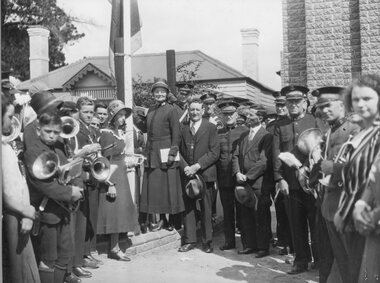
Photograph, Salvation Army Citadel Opening 1934
Photograph on mounted card taken at the official opening of Citadel Main Street Stawell. In the background a private dwelling with corrugated iron roof and weatherboard walls. At right brick building. Bands people and civilians standing around a flagpole. To the right of the flagpole. Mrs. Maxwell (standing on the brickwork), Mr. W. Freeland (Major). Commissioner Maxwell. Mr. W. Sharpley (Town Clerk) Major Wilkinson.Black & white photo on a mounted card with a boarder. The photo is of a group of people some with musical instruments beside a flagpole. In the background is a weather board house with a corrugated iron roof. To the right a brick building. W. J. Chapman Photo Artist Stawell. Reeve (in pencil).stawell religion -
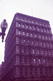
 Bendigo Historical Society Inc.
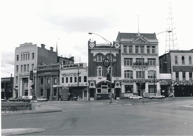
Photograph - VIEW POINT BENDIGO
Black and white photo of View Point, Bendigo. Commercial buildings - National Mutual, Cahill Solicitors, Whelans Solicitors, Colonial Mutual Building, ( Whirrakee Restaurant ) AMP building, Armstrongs Tyres and Army Disposals. Radio Tower.Peter Hyatt 1995place, streetscape, view point/pall mall -
 Bendigo Historical Society Inc.
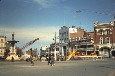
Slide - BENDIGO BUILDINGS, Oct 1964
Slide. Bendigo Buildings. A red crane doing construction work at Charing Cross, between the fountain and cenotaph, with the City Family Hotel on the left, the View Point Hotel, RACV Building, Colonial Mutual Life Building on right.slide, bendigo, bendigo buildings., bendigo buildings. -
 Kilmore Historical Society
Photograph, 27 Sydney Street
13cm x 20.5cm black and white photograph of the State Bank at 27 Sydney Street. It is a medium coloured brick double story building. There is traffic lights out the front the building. There is also a clock hanging from the building.banks, banks and banking -
 Federation University Historical Collection
Drawing - Rubbing, Rubbing on a plaque relating to the Sky High Restaurant
This is thought to be the work of Keith Rash of Ballarat.A number of rubbings from plaques on buildings. .1) Sky High Restaurant .2) Pioneers Tablet (Probably relating to the Pioneers Plot at the Ballaarat Old Cemetery. .3) and .4) Plaque relating to the Pioneers tablet.1) This Skyhigh restaurant was officially opened by The Hon. Vance Dickie M.L.C. Minister for Tourism on the 25th March 1971 This building was planned and constructed for The Ministry of Tourism J. Dale Fisher F.R.A.I.A. Architect W.J. Cody & Quinn Pty Ltd Builders .2) (logo) This tablet was erected by the citizens of Ballarat in honour of the pioneers of this city and district. .3) This MEMORIAL TABLET was unveiled on the 3rd May 1961 by F.W. WRAY, Esq in the company of S.C. HENDERSON, Esq. The only remaining members of the Original Pioneers Memorial Committee.architecture, j. dale, w, j, cody & quinn, skyhigh restaurant, frottage, rubbing, ballarat pioneers, keith rash -
 Federation University Historical Collection
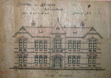
Plan, Ballarat School of Mines New Classrooms (now Administration Building), 1899, 16/02/1899
In 1900 this building was described as 'handsome in design, well lit, well ventilated, commodious - containing Council room, office, chemical laboratory, mineralogical laboratory, students room and six lecture rooms. Original hand coloured plan on linen of the Ballarat School of Mines New Classrooms (in 2014 known as the Federation University Australia SMB campus Administration Building). The plan shows the front elevation, section on line, ground and 1st floor plan. Copy in black frame with cream mount.ballarat school of mines, new classrooms, administration building, architectural plans, a building -
 Mission to Seafarers Victoria
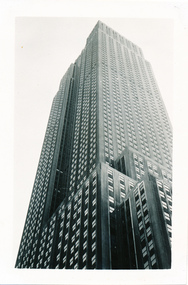
Photograph - Photograph, Black and white, Allan Charles Quinn, 5 October 1949
Allan Charles Quinn was a member of the Merchant Navy from aged 16 as well as being a trained photographer. This photograph was taken during his travels through America whilst still being associated with the Merchant Navy.This photograph of the Empire State building is a part of the Allan Charles Quinn Collection which is a photographic autobiography of the life of an individual seafarer.Black and white photograph of the Empire State Building, New York, taken from street level looking towards the top of the building.Handwritten in blue ink on reverse of photograph: "EMPIRE STATE/ 5-10-49".seamen, america, fifth-avenue, allan charles quinn, merchant navy, new york, skyscraper -
Glenelg Shire Council Cultural Collection
Clothing - Tie, n.d
Red tie, all over motif stickfigure standing on domed roof of building, other buildings behind. Centenary of Federation 1999.tie, mens clothing, souvenir clothing, souvenir -
 Federation University Historical Collection
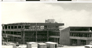
Photograph - Black and White, Federation University E.J. Barker Library Under Construction, 1972, 1972
Federation University E.J. Barker Library Under Construction. The Coates Building (formerly the Union Building) is located in the right foreground of the photograph.federation university, e.j. barker library, mt helen library, union building, coates building -
 Port Melbourne Historical & Preservation Society
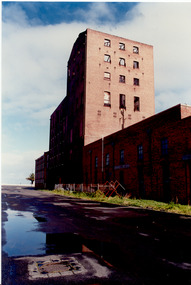
Photograph - Harper's factory buildings, Beach and Rouse Streets, Port Melbourne. Awaiting redevelopment, 1980s
Harper factory buildings on Beach and Rouse Streets (colour photo). c 1980s External view of some of the buildings awaiting redevelopmentbuilt environment, built environment - commercial, harper's, redevelopment -
 Robin Boyd Foundation
Slide, Robin Boyd
Colour slide in a mount. Sun Insurance Building, Queen Prell Building, Collins and Queen St, Melbourne, Victoria, Australia (demolished)File No / Titleslide, robin boyd -
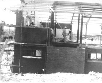 Slovenian Association Melbourne
Photo, Building of the corner of the new centre at Eltham 1972
Photo of the building team laying the bricks at the corner of the new centre. The work was voluntary at the weekends, but the building was growing quite fast. On the photo are:slovenian association melbourne, building, 1972 -
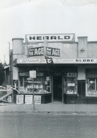 Ballarat Heritage Services
Photograph - Photograph - Black and White, North Kew Authorised Newsagency, c1964, c1964
This photograph was taken before a major renovation of the shop. It was owned and run by John Hogan Gervasoni and Kathleen Gervasoni for seventeen years from c1959.Black and white of North Kew Authorised Newsagency and Post Office before renovations, including building over driveway to the left of the building. north kew authorised newsagency, post office, newsagency, john hogan gervasoni, kathleen gervasoni, north kew, north kew newsagency -
Bendigo Historical Society Inc.
Book - Bendigo and Northern District Base Hospital Re-building Programme, 1964
Parry CollectionBendigo and Northern District Base Hospital Re-building Programme. Four Pages which illustrates the second stage of re-building.history, bendigo, j s parry collection, bendigo hospital -
Lakes Entrance Historical Society
Book, Marquis-Kyle, Peter and Walker, Meredith, The Illustrated Burra Charter, 1994
A detailed description of the 'Burra Charter' with many illustrations of buildings and objects associated with heritage artifacts, buildings, sites of cultural and Aboriginal significance.photography, architecture, heritage -
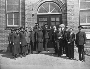 Stawell Historical Society Inc
Photograph, Salvation Army Citadel Official Opening December 1934
Salvation Army Citadel Opening 1934. People in front of Citadel. Front Row from Left Mrs. Wilkinson, Mrs. Haines, Capt. Morris, Brig. Smalley, Col. Henry Mrs. Maxwell, Comm. Maxwell, Cr. Freeland, (Mayor), Col. Haines, Cr. R. McCracken, Rev. Ewin, Rev. Graham, Mr. Sharpley, Major Wilkinson. Black and white photograph of a group of people in uniform at an entrance to a brick building. The man in the center of the group appears to be opening the door to the building.. W.J. Chapman Photo artist Stawell. Col. A. Henry, Commissioner Maxwell, Col. W. Haines, Brig. F. Smalley, Mr. S. Freeland, Mayor of Stawell, Mr. R McCracken, Capt. F. Morris, Mrs. Col Haines, Mrs. Major Wilkinson, Town Clerk Mr. Sharpley, Major F. Wilkinson.stawell religion -
 Port Melbourne Historical & Preservation Society
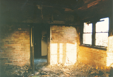
Photograph - Exterior of Chaplain's quarters, Missions to Seamen, Port Melbourne, after fire, National Trust of Victoria, 1994
Photographed by the National Trust to record damage to building after May 1994 fireFrom album of photos mostly by Alison Kelly: Port Melbourne Missions to Seamen, interior of chaplain's quarters; photo taken by National Trust after May 1994 fire in chaplain's lounge room fireplace, probably caused through carelessness of squatters. (Groups of squatters broke in and occupied the building as soon as the Office of Major Projects had evicted caretakers Alison Kelly and Brian Couldrey.missions to seamen, built environment, crimes and misdemeanours, fire and fire services, alison kelly -
 Federation University Historical Collection
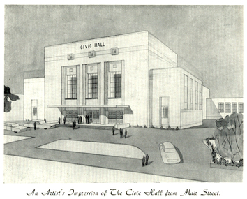
Programme, The Opening of Civic Hall, 1956, 1956
The City of Ballarat unanimously resolved to erect a Civic Hall in Mair Street in 1951. The architects, Gordon Murphy, of Melbourne, and H.L. and L.J. Coburn, of Ballarat, were commissioned in 1952. The Council constructed the foundations and footings for the building under the supervision of the former City engineer, Mr L.H. Finch, in 1953. These footings are of massed concrete. The design for the building took advantage of the cross fall of the land, providing for the Small Hall to be entered from the Doveton Street frontage through a foyer under the Main Stage, the structure is steel with brick panels, with accommodation for 1,592 persons in the Main Hall and 440 persons in the Lower Hall. The front facade faces Mair Street, set back from the building line to provide for the entrance drive-ways and kerbed gardens. Tenders were invited on a firm price basis. A young Ballarat master Builter, Walter Benbow Trahar was the successful tenderer, the contract price being 139,841 pounds. the work was commenced in 1953 and has proceeded in spite of material and labour difficulties until its completion. The following statistics are of interest:- * The foundations contained 200 cubic yards of concrete. * The constructional steel work weighs approximately 270 tons. * The reinforcing steel 47 tons. * Reinforced concrete in the structure, 1,100 cubic yards. * The approximate number of bricks in the building, 580,000. * The flooring is of selected kiln-dried hard wood and totals 40,000 lineal feet. * The dimensions of the Main Auditorium, 100ft by 86 ft, including the side promenades each 82ft by 13ft. *The Main stage, of reinforced concret with parquette finish measures 62 ft by 40ft. *The floor area of the Lower Hall is 74 ft by 38 ft, and has a stage dimensions of 40ft by 20 ft. * Each hall has independent heating and ventillating systems. Where possible the material in the building was furnished from local business houses. The public address installation, which provided for additional microphones, is on the main Stage. There is inter-communication throughout the building connecting the front office, with the bioscope box, the stages in both the large and lower halls, and the Hallkeeper's residence. Local craftsmen have completed the painting, plaster work, and the electrical installation; local produced materials being used in the construction of the buildings with the exception of the timber for the Main Floor, the roofing and the structural steel. The City of Ballarat Councillors in 1956 were Councillors N. T. Callow, F.J. Cutts, K.C. Webb, W.E. Roff, O.W. Curnow, F.T. Woodward, Allan C. Pittard, A.W. Nicholson, J.A. Chisholm, G.L. Scott, F.W. Oliver, A.D. Mason. The Town clerk was H.R. Maddern and the City Engineer was G. Murrowood. A City of Ballarat Council meeting of 25 September 2013 voted to demolish the Ballarat Civic Hall. The Council heard from nearly 50 members of the public during a marathon six-hour meeting. Councilors John Birt, Des Hudson, Amy Johnson, Josh Morris, Peter Innes, John Philips supported the motion to demolish Civic Hall. Councillors Samantha McIntosh, Vicki Coltman and Belinda Coates voted against the motion.Six page souvenir Program of citizens' entertainment on the occasion of the Opening of Ballarat Civic Hall on in August 1956. The front cover features the City of Ballarat Coat of Arms. The programme starts with a message from the Mayor, Cr Neil T. Carrow. It includes the Concert Programme directed by James H. Davey, an asrtist's impression of the Civic Hall from Mair Street, and information relative to the New Civic Hall. The programme features images of the City of Ballarat Coat of Arms, Cr N.T. Callow, , James H, Davey, and an artist's impression of the Ballarat Civic Hall. Mayor Neil Callow's Message: "To-day, our citizens witness the fulfilment of the most extensive Municipal undertaking in the City's period of recent prosperity and development. Their Hall now fills a requirement of which they have been deprived since the Coliseum building was destroyed by fire over 20 years ago. The building has been designed as an all purpose structure and I am hopeful the citizens will use it and enjoy it to its fullest extent. Your Council and its Architects have planned as broadly as possible for the benefit of all to-day and for years to come. We are proud of the work executed by a Ballaarat Master Builder whose work is a monument to the City's craftsmen. I feel I should also remind this assembly that the women of Ballaarat, back in 1951, provided funds which have been applied in the purchase of a Grand Piano and two Upright Pianos which are now installed in this building. The sincere hope of myself and your Councillors is that this Hall and its amenities will prove of immense value to the development of the cultural and artistic tastes of this community and that it will be freely used for these and many other purposes. From now on this magnificent building and its furnishings and equipment will be available to all. I strongly exhort you to use and protect it. My hope is that the citizens will, for many years to come, enjoy the amenities which it has to offer. ballarat civic hall, civic hall, architecture, finch, art deco, city of ballarat, coat of arms, city of ballarat coat of arms, callow, shugg, lemke, oates, gullan, tuuri, john, robertson, sorrell, antonio, gordon murphy, walter benbow trahar, trahar, coburn, h.l. coburn, l.j. coburn, n.t. callow -
 Stawell Historical Society Inc
Photograph, St. Patrick’s Catholic Church
St. Patrick’s Catholic Church and surrounding buildings 1880's. The church was opened in 1873. The construction is of Black Ranges faced with Grampians Freestone. The bell tower is 70 feet high, and the walls are 30 inches thick. The church was opened on 30th March 1873 by the Bishop of Melbourne, the Right Reverend Dr. Goold. The Historical Society have a programme for this opening - tickets for front seats were 10/- each. The sanctuary was added during 1927 as was a white marble altar which was the gift of a parishioner. Much earlier - In 1865 - a wooden Catholic Church was built on this street near the Court House site. The wooden building became too small for the congregation and this church was commenced before the end of 1869. Sepia photograph of St Patrick's Catholic Church and surrounding buildings. The photo also shows mining operations in Stawell with the Grampians in the background c 1880's. Two enlargements of the Catholic Church are taken from the sepia photograph and marked as 105a.C. Herbert. Photo. Copyright Registered Stawell. on the back is written "Stawell from Big Hill c 1880" stawell, panorama, mining -
 Federation University Historical Collection
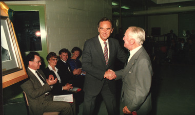
Photograph - Colour, Official Opening of the Ballarat School of Mines M.B. John Building, 1987, 11/06/1987
... buildings ...On 11 June 1987 The M.B. John Trade–Art building of SMB was officially opened by the Hon. John Cain, Premier of Victoria, in the presence of Morgan B. John. Programs in the building include 3 Dimensional Art, Painting & Decorating, and Engineering Trades.Coloured photograph showing Premier John Caine shaking hands with Morgan Bevan John. John Mildren is seated in a brown suit, and Cr Elizabeth Sheedy sits beside him. m.b. john, morgan bevan john, morgan b. john, m.b. john building, albert street, trade building, ballarat school of mines, buildings, john cain, liz sheedy, john mildren, visitors -
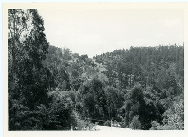 Mt Dandenong & District Historical Society Inc.
Photograph, View From Doughty's Road 1974
John Lundy-Clarke grew up in the Kalorama/Mt Dandenong area and later in life (1972-74) began to write a comprehensive history of the area working from an original settlement map in an effort to cover all areas. This photograph shows approximately the same area as photograph number KAL0193 but is taken 60 years later. The trees have grown much taller and the buildings changed. On the site of the Paynter house 'Iona' there is now the 'Yosemite' (Villa Toscana) accommodation. The pavilion in the centre of the photo is the site of 'Kalorama', home of early pioneer Isaac Jeeves. The photograph is taken looking up towards The Gap (FiveWays).Black and white photograph showing a forested area with clear sites. Roofs of buildings can be clearly seen. Handwritten inscription on reverse by John Lundy-ClarkeView from near Doughty’s Rd looking north up valley to Kalorama Gap in Jan 1973. Tiny roof in centre is pavilion on site of “Kalorama”. Long roof to its left is Yosemite Motel on site of “Iona”.paynter, kalorama, iona, yosemite, villa toscana, five ways, the gap -
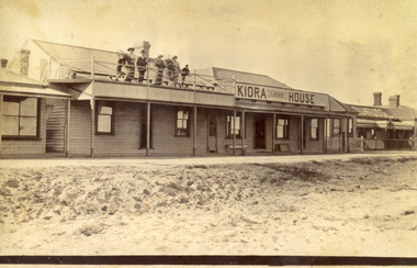 Lakes Entrance Historical Society
Photograph - Kiora House, 1920c
Also copy enlargement 12 cm x 19 cm Kiora House was purchased by Mrs C Beveridge from Mrs Begg. (Original building, A Murray's store, then Barkes store, before Barkes built near Post Office). House to the left purchased later, balcony built over veranda, this place removed and demolished for family home to be built later.Sepia toned photograph of Kiaora House. Houses on the left and the right. Sandy or Gravel roadway in front of building. Sand at the lake front in foreground of photo. People standing on upper balcony. Lakes Entrance VictoriaKiaora Housearchitecture, township, tourism, room display, local history -
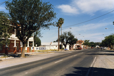 Charlton Golden Grains Museum Inc
Photograph, High St Charlton, east end, southside c. 1987, c.1987
Cricket Club Hotel established 1875, rebuilt as a two storey building 1935. Photograph part of the Shire of Charlton streetscape 1987Colour photograph looking west along High St. Cricket Club Hotel on the other side of the road with a large tree in front of the building. Blue and white signage for Steve Hill Ford further along with two palm trees at the front. Cars parked along both sides of the street. A person riding a bike toward the photographer.cricket club hotel, high st charlton, charlton, business, industry -
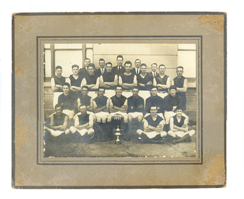 Tarnagulla History Archive
Tarnagulla Football Club Premiership team 1931 (Williams copy), Tarnagulla Football Club Premiership team 1931, 1931
Murray Comrie Collection. The players are posed in front of Tarnagulla Town Hall (also known as Burstall Hall) in the main street of Tarnagulla. The building has since been demolished.Mens football team posed in four lines in front of large building. All are wearing black tops and white shorts. Man at centre front is holding a football on which is painted PREMIER 1931. Probably taken in front of Tarnagulla Town Hall otherwise known as Burstall Hall (now demolished).Names of subjects and name 'L.Williams' handwritten on reverse.tarnagulla, sport, football, radnell, mcnamee -
 Kew Historical Society Inc
Plan, Melbourne & Metropolitan Board of Works : Borough of Kew : Detail Plan No.1302, 1910
The Melbourne and Metropolitan Board of Works (MMBW) plans were produced from the 1890s to the 1950s. They were crucial to the design and development of Melbourne's sewerage and drainage system. The plans, at a scale of 40 feet to 1 inch (1:480), provide a detailed historical record of Melbourne streetscapes and environmental features. Each plan covers one or two street blocks (roughly six streets), showing details of buildings, including garden layouts and ownership boundaries, and features such as laneways, drains, bridges, parks, municipal boundaries and other prominent landmarks as they existed at the time each plan was produced. (Source: State Library of Victoria)This plan forms part of a large group of MMBW plans and maps that was donated to the Society by the Mr Poulter, City Engineer of the City of Kew in 1989. Within this collection, thirty-five hand-coloured plans, backed with linen, are of statewide significance as they include annotations that provide details of construction materials used in buildings in the first decade of the 20th century as well as additional information about land ownership and usage. The copies in the Public Record Office Victoria and the State Library of Victoria are monochrome versions which do not denote building materials so that the maps in this collection are invaluable and unique tools for researchers and heritage consultants. A number of the plans are not held in the collection of the State Library of Victoria so they have the additional attribute of rarity.Original survey plan, issued by the MMBW to a contractor with responsibility for constructing sewers in the area identified on the plan within the Borough of Kew. The plan was at some stage hand-coloured, possibly by the contractor, but more likely by officers working in the Engineering Department of the Borough and later Town, then City of Kew. The hand-coloured sections of buildings on the plan were used to denote masonry or brick constructions (pink), weatherboard constructions (yellow), and public buildings (grey). The absence of buildings and or property in Kew facing the Yarra is the most notable feature of this plan. Walmer Street and its bridge stretched, then and now, from Studley Park Road to Victoria Street, Richmond. On the Richmond side of the Yarra, there was evidence in 1904 of industry (‘Wool shed’; Soap Works’) and entertainment (‘Skittle Alley’). In reality, another Plan (No.1303) shows Chinese Gardens bordering the Yarra on the Kew side and buildings in Young Street.melbourne and metropolitan board of works, detail plans, mmbw 1302, cartography -
Port Melbourne Historical & Preservation Society
Photograph - Entrance to J Kitchen & Sons, Quinn Street, Port Melbourne, 1928
Black and white photograph of Quinn St entrance to J Kitchen and Sons showing brick entrance buildings with a three storey Administration Building behind the building on the left. Two trucks are parked in the entrance and four men standing beside the cars and buildings. Typed label on top right hand corner "Port Melbourne 1928"industry - manufacturing, built environment - industrial, transport - motor vehicles, workers, j kitchen & sons pty ltd -
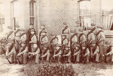 Surrey Hills Historical Society Collection
Photograph - Surrey College Cadet Corps, 1899, 1899
Surrey College was opened in early 1892 by Rev. Dr Frederick Darling who had been the first minister of the Presbyterian Church in Canterbury Road. He resigned this position to open the school which operated until 1908 with additional premises at 12 Vincent Street. The school had 40 boarders as well as day boys. Courses included algebra, euclid, history, typewriting, shorthand and drill. In the 1930s, Nethercourt Private Hospital took over the site. Later it became St Jude's Hospital. land in front of the building was subdivided off in the 1970s. The building is still extant as a private dwelling with York Street, Surrey Hills as the address. This is one of 3 photos donated by Susan Hobbs, whose grandfather Rev. George Edward Downton is thought to have been a student at the college. George E. Downton was born in Avoca in 1885. He was later a missionary in New Guinea and Secretary to the Australian Board of Missions in Adelaide. He died in 1926 or 1927. Sepia photo of 26 men and boys dressed in military uniform, many holding rifles. They are standing in front of a brick building with bay windows with blinds and curtains. There is a clump of foliage and grass in front of boys. "Surrey College - Surrey Hills / Principal: Rev Frdk. A. Darling, Melb. Univ./Cadet Corps, 1899." On the mount below the photo. Inscription on bottom right hand corner of photo: "Prepare for cavalry"schools, 1899, surrey hills, surrey college, rev frederick a darling, george edward downton, susan hobbs, union road, nethercourt hospital, st jude's hospital, 219-223 union road, cadet corps, 1890-1899 -
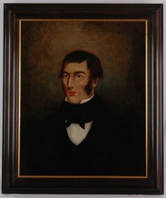 Glenelg Shire Council Cultural Collection
Painting, Joshua Black, c. 1850
... Buildings ...Joshua Black was an Irish Stonemason who came to Portland. He helped to build many significant buildings including what is now the Royal Hotel and Julia Street Creative Space as well as the Scotts Presbyterian Church.Portrait of a man against a blank brown and black background. He is in formal attire, with black jacket, high-collared white shirt and black cravat. His hair (black) is parted on the left and he has side burns descending past his cheekbones. Framed in a black frame with gilding.Front: (no inscriptions) Back: (no inscriptions) Conservation Centre, Melbourne - label.portrait, portraits, male, man, victorian, portland, buildings, builder