Showing 22516 items
matching copying
-
![Photograph - Digital image, Greenbriar Nursery [Greensborough], 02/05/2013](/media/collectors/4f729f5697f83e03086015b8/items/5729ba9e2162f108e8de4df7/item-media/5729bad92162f108e8de534e/item-fit-380x285.jpg) Greensborough Historical Society
Greensborough Historical SocietyPhotograph - Digital image, Greenbriar Nursery [Greensborough], 02/05/2013
These photographs of the Greenbriar Nursery site were taken in 2013 to show changes over 40 years, based on Ron Reynold’s sketches in the 1973 publication “Greensborough and Greenhills” published by Cypress Books. Although the site now has a house on it, the Nursery drive is still visible. This site is in Mountainview Road.Digital copy of colour photograph.greensborough and greenhills, mountainview road briar hill, greenbriar nursery, ron reynolds -
![Photograph - Digital image, House St Helena and Diamond Creek Roads [Greensborough], 02/05/2013](/media/collectors/4f729f5697f83e03086015b8/items/5729bbd22162f108e8de5be2/item-media/5729bc112162f108e8de617d/item-fit-380x285.jpg) Greensborough Historical Society
Greensborough Historical SocietyPhotograph - Digital image, House St Helena and Diamond Creek Roads [Greensborough], 02/05/2013
These photographs of the house on the corner of St Helena and Diamond Creek Roads was taken in 2013 to show changes over 40 years, based on Ron Reynold's sketches in the 1973 publication 'Greensborough and Greenhills' published by Cypress Books... which states "Built on a steep hill in a bush setting in the early 1920s, for a Dr Wood, the weatherboard house now overlooks an area of activity and change. The owners, Mr and Mrs E. 'Bluey' Blackburn, remember when their 3/4 acre building block dropped to the edge of a dirt road. Today the view from the high verandah encompasses the Main Street shopping centre, new and old bridges, new roads and houses, the Plenty River, natural bush, hills and sports grounds."Digital copy of colour photograph.greensborough and greenhills, st helena road greensborough, diamond creek road greensborough, wood family, ron reynolds -
![Photograph - Digital image, Kelly Garden Supplies [Greensborough], 02/05/2013](/media/collectors/4f729f5697f83e03086015b8/items/5729bced2162f108e8de6b52/item-media/5729bd212162f108e8de74aa/item-fit-380x285.jpg) Greensborough Historical Society
Greensborough Historical SocietyPhotograph - Digital image, Kelly Garden Supplies [Greensborough], 02/05/2013
This photograph of the former site of Kelly Garden Supplies was taken in 2013 to show changes over 40 years, based on Ron Reynold’s sketches in the 1973 publication “Greensborough and Greenhills” published by Cypress Books. The site is now part of the Civic roundabout at the top of the Greensborough By-pass. Civic Drive was associated with the building of Diamond Valley Council Offices opened by Governor Rohan Delacombe on 26/2/1972. Previously it was known as Kelly's Track which wound its way around to a house that overlooked the aqueduct bridge. Kelly's Sandpit (quarry) was the local go to place to obtain road, driveway fill and red sand for local construction. For 80 years previous Kelly's quarry supplied sand to the greater Melbourne area for the surfacing of school grounds, parks etc. Digital copy of colour photograph.greensborough and greenhills, civic drive greensborough, kelly garden supplies, ron reynolds -
![Photograph - Digital image, Lobb's Tea Rooms [Greensborough], 02/05/2013](/media/collectors/4f729f5697f83e03086015b8/items/5729bdeb2162f108e8de77e5/item-media/5729be182162f108e8de798c/item-fit-380x285.jpg) Greensborough Historical Society
Greensborough Historical SocietyPhotograph - Digital image, Lobb's Tea Rooms [Greensborough], 02/05/2013
This photograph of the former Lobb's Tea Rooms was taken in 2013 to show changes over 40 years, based on Ron Reynold’s sketches in the 1973 publication “Greensborough and Greenhills” published by Cypress Books. The building is now part of the Diamond Valley Learning Centre.Digital copy of colour photograph.greensborough and greenhills, lobbs tea rooms, lobbs kiosk, ron reynolds, diamond valley learning centre -
![Photograph - Digital image, Methodist Church [Greensborough], 02/05/2013](/media/collectors/4f729f5697f83e03086015b8/items/5729bea92162f108e8de81fa/item-media/5729bed62162f108e8de8384/item-fit-380x285.jpg) Greensborough Historical Society
Greensborough Historical SocietyPhotograph - Digital image, Methodist Church [Greensborough], 02/05/2013
This photograph of the Greensborough Methodist Church was taken in 2013 to show changes over 40 years, based on Ron Reynold’s sketches in the 1973 publication “Greensborough and Greenhills” published by Cypress Books. This building is in Grimshaw Street and houses the Living Faith Church.Digital copy of colour photograph.greensborough and greenhills, greensborough methodist church, ron reynolds, living faith church -
![Photograph - Digital image, Rand Street Bridge [Greensborough], 02/05/2013](/media/collectors/4f729f5697f83e03086015b8/items/572af0f12162f118342f250e/item-media/572af1252162f118342f2a1f/item-fit-380x285.jpg) Greensborough Historical Society
Greensborough Historical SocietyPhotograph - Digital image, Rand Street Bridge [Greensborough], 02/05/2013
These photographs of the Rand Street Bridge were taken in 2013 to show changes over 40 years, based on Ron Reynold’s sketches in the 1973 publication “Greensborough and Greenhills” published by Cypress Books. This is a pedestrian swing bridge over the Plenty River between Rand Street and Greensborough Station.Digital copy of colour photograph.greensborough and greenhills, rand street bridge, rand street greensborough, ron reynolds -
![Photograph - Digital Image, St Katherine's Church [St Helena], 02/05/2013](/media/collectors/4f729f5697f83e03086015b8/items/572af5ff2162f118342f9924/item-media/572af6362162f118342f9ce7/item-fit-380x285.jpg) Greensborough Historical Society
Greensborough Historical SocietyPhotograph - Digital Image, St Katherine's Church [St Helena], 02/05/2013
These photographs of St Katherine's Anglican Church St Helena were taken in 2013 to show changes over 40 years, based on Ron Reynold’s sketches in the 1973 publication 'Greensborough and Greenhills' published by Cypress Books.Digital copy of colour photographs.greensborough and greenhills, ron reynolds, st katherines church st helena, beale family -
 Greensborough Historical Society
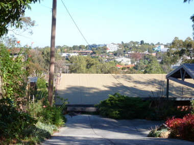
Photograph - Digital image, View of Greensborough from Delfin Crescent, 02/05/2013
This photograph of Greensborough was taken from Delfin Crescent in 2013 to show changes over 40 years, based on Ron Reynold’s sketches in the 1973 publication “Greensborough and Greenhills” published by Cypress Books. Delphin Crescent [previously known as Medhurst Street] was created about 1970 in association with the Delfin Building Company. It was at this time also, that major works on Diamond Creek Road raised the level of the road facilitating the connection of Delfin Crescent with Diamond Creek Road. [Note: 'Medhurst Street was only listed on planning maps pre 1950 when the 'street' had no residents or development.]Digital copy of colour photograph.greensborough and greenhills -
 Greensborough Historical Society
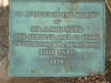
Photograph - Digital Image, Plaque - Greensborough Lower Park, 1974_
Photograph of Plaque located in Greensborough's Lower Park. The inscription reads: "To perpetuate the memory of Mr.A.W.H.Webb for services over 25 years in founding and developing this park 1974"Digital copy of colour photograph.greensborough, lower park greensborough -
 Greensborough Historical Society
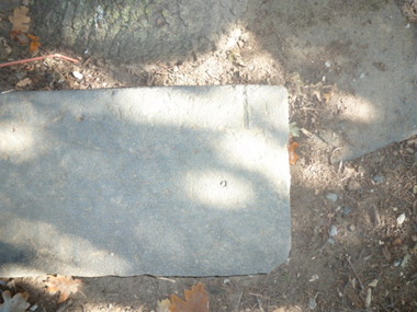
Photograph - Digital image, Park stones, Greensborough Lower Park, 02/05/2013
Photograph of stones located in Greensborough's Lower Park.Digital copy of colour photographs. -
 Greensborough Historical Society
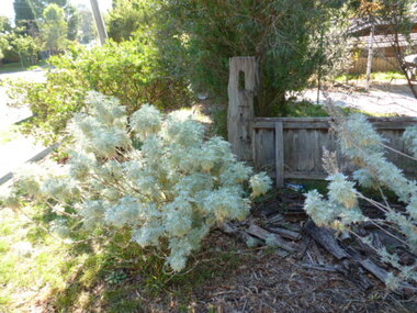
Photograph - Digital image, Old Post, Mountainview Road, 02/05/2013
Photograph of old hitching post located in Mountainview Road Briar Hill. The post is located in the front garden of a residential block.Digital copy of colour photograph.mountainview road -
 Greensborough Historical Society
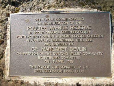
Photograph - Digital image, Plaque - Poulter Avenue Reserve Greensborough, 18/04/1988
Photograph of Plaque located in Greensborough's Poulter Avenue Reserve. The inscription reads: "This plaque commemorating the beautification of the Poulter Avenue Reserve by scout groups, Greensborough Youth Activity Centre & local school children in Australia's Bicentennial year 1988 was unveiled by Cr. Margaret Devlin chairperson of the Diamond Valley Community Bicentenary Committee on 18 April 1988. This plaque was donated by the Greensborough Lions Club" Digital copy of colour photograph.poulter avenue reserve greensborough -
![Photograph - Digital Image, Marsh House [38 Hailes Street] 2014 4, 21/05/2014](/media/collectors/4f729f5697f83e03086015b8/items/550a92cb2162f10974c8c585/item-media/550a92f72162f10974c8c837/item-fit-380x285.jpg) Greensborough Historical Society
Greensborough Historical SocietyPhotograph - Digital Image, Marsh House [38 Hailes Street] 2014 4, 21/05/2014
Built by Jonah Britnell in 1860s, this house was sold to the Marsh family about 1909. The home still stands on the corner of Hailes and Church Street Greensborough Photograph taken in 2014 by Marilyn Smith.Digital copy of colour photograph.britnell, marsh, hailes street -
![Photograph - Digital Image, Marsh House [38 Hailes Street] 2014 5, 21/05/2014](/media/collectors/4f729f5697f83e03086015b8/items/550a934c2162f10974c8d1cf/item-media/550a93792162f10974c8d697/item-fit-380x285.jpg) Greensborough Historical Society
Greensborough Historical SocietyPhotograph - Digital Image, Marsh House [38 Hailes Street] 2014 5, 21/05/2014
Built by Jonah Britnell in 1860s, this house was sold to the Marsh family about 1909. The home still stands on the corner of Hailes and Church Street Greensborough Photograph taken in 2014 by Marilyn Smith.Digital copy of colour photograph.britnell, marsh, hailes street -
![Photograph - Digital Image, Marsh House [38 Hailes Street] 2014 6, 21/05/2014](/media/collectors/4f729f5697f83e03086015b8/items/550a93d62162f10974c8e58f/item-media/550a94042162f10974c8e942/item-fit-380x285.jpg) Greensborough Historical Society
Greensborough Historical SocietyPhotograph - Digital Image, Marsh House [38 Hailes Street] 2014 6, 21/05/2014
Built by Jonah Britnell in 1860s, this house was sold to the Marsh family about 1909. The home still stands on the corner of Hailes and Church Street Greensborough Photograph taken in 2014 by Marilyn Smith.Digital copy of colour photograph.britnell, marsh, hailes street -
 Greensborough Historical Society
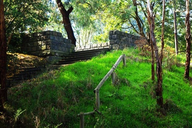
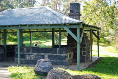
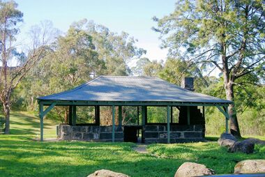
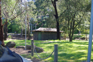
Photograph - Digital Image, Pioneer Reserve 2014 -1, 21/05/2014
Pioneer Reserve, Greensborough is a small park on the corner of St Helena and Diamond Creek Roads. It is adjacent to the site of Greensborough's first bridge across the Plenty River, c. 1864 - 1960s. The shelter, viewing platform, retaining wall and entrance are built from the bridge's massive bluestone arched abutments dismantled between 1974 and 1983. Pioneer Reserve is historically significant for its formative association with noted local landscape designer Gordon Ford in 1968, and it is likely that remnant large field stones at the entrance drive to the Reserve remain from his design. Photograph by Marilyn Smith 2014.Digital copy of colour photograph. -
 Greensborough Historical Society
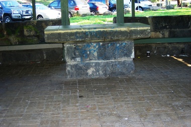
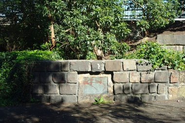
Photograph - Digital Image, Pioneer Reserve 2014 -2, 01/10/2014
Pioneer Reserve, Greensborough is a small park on the corner of St Helena and Diamond Creek Roads. It is adjacent to the site of Greensborough's first bridge across the Plenty River, c. 1864 - 1960s. The shelter, viewing platform, retaining wall and entrance are built from the bridge's massive bluestone arched abutments dismantled between 1974 and 1983. Photograph by Marilyn Smith 2014.Digital copy of colour photograph.pioneer reserve greensborough -
 Greensborough Historical Society
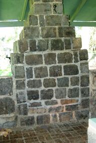
Photograph - Digital Image, Pioneer Reserve 2014 -3, 01/10/2014
Pioneer Reserve, Greensborough is a small park on the corner of St Helena and Diamond Creek Roads. It is adjacent to the site of Greensborough's first bridge across the Plenty River, c. 1864 - 1960s. The shelter, viewing platform, retaining wall and entrance are built from the bridge's massive bluestone arched abutments dismantled between 1974 and 1983. Photograph by Marilyn Smith 2014.Digital copy of colour photograph.pioneer reserve greensborough -
 Greensborough Historical Society
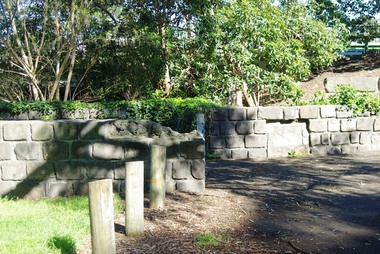
Photograph - Digital Image, Pioneer Reserve 2014 -4, 23/09/2014
Pioneer Reserve, Greensborough is a small park on the corner of St Helena and Diamond Creek Roads. It is adjacent to the site of Greensborough's first bridge across the Plenty River, c. 1864 - 1960s. The shelter, viewing platform, retaining wall and entrance are built from the bridge's massive bluestone arched abutments dismantled between 1974 and 1983. Photograph by Marilyn Smith 2014.Digital copy of colour photograph.pioneer reserve greensborough -
 Greensborough Historical Society
Photograph - Digital Image, Pioneer Reserve 2014 -5, 23/09/2014
Pioneer Reserve, Greensborough is a small park on the corner of St Helena and Diamond Creek Roads. It is adjacent to the site of Greensborough's first bridge across the Plenty River, c. 1864 - 1960s. The shelter, viewing platform, retaining wall and entrance are built from the bridge's massive bluestone arched abutments dismantled between 1974 and 1983. Photograph by Marilyn Smith 2014.Digital copy of colour photograph.pioneer reserve greensborough -
 Greensborough Historical Society
Photograph - Digital Image, Pioneer Reserve 2014 -6, 23/09/2014
Pioneer Reserve, Greensborough is a small park on the corner of St Helena and Diamond Creek Roads. It is adjacent to the site of Greensborough's first bridge across the Plenty River, c. 1864 - 1960s. The shelter, viewing platform, retaining wall and entrance are built from the bridge's massive bluestone arched abutments dismantled between 1974 and 1983. Photograph by Marilyn Smith 2014.Digital copy of colour photograph.pioneer reserve greensborough -
 Greensborough Historical Society
Photograph - Digital Image, Pioneer Reserve 2014, 23/09/2014
Pioneer Reserve, Greensborough is a small park on the corner of St Helena and Diamond Creek Roads. It is adjacent to the site of Greensborough's first bridge across the Plenty River, c. 1864 - 1960s. The shelter, viewing platform, retaining wall and entrance are built from the bridge's massive bluestone arched abutments dismantled between 1974 and 1983. Photograph by Marilyn Smith 2014.Digital copy of colour photograph.pioneer reserve greensborough -
 Greensborough Historical Society
Photograph - Digital Image, Pioneer Reserve 2014 -8, 23/09/2014
Pioneer Reserve, Greensborough is a small park on the corner of St Helena and Diamond Creek Roads. It is adjacent to the site of Greensborough's first bridge across the Plenty River, c. 1864 - 1960s. The shelter, viewing platform, retaining wall and entrance are built from the bridge's massive bluestone arched abutments dismantled between 1974 and 1983. Photograph by Marilyn Smith 2014.Digital copy of colour photograph.pioneer reserve greensborough -
 Greensborough Historical Society
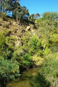
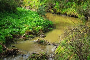
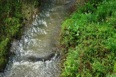
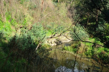
Photograph - Digital Image, Plenty River Greensborough, May 2014 -10, 21/05/2014
The Plenty River flows south from Mt Disappointment before meeting with the Yarra River at Rosanna. Early settlement in Greensborough was based around the Plenty River. These images were taken in the Greensborough area by Marilyn Smith May 2014.Digital copy of colour photograph.plenty river -
 Greensborough Historical Society
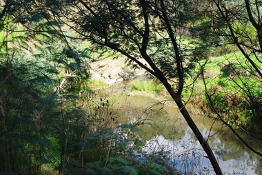
Photograph - Digital Image, Plenty River Greensborough, May 2014 -9, 21/05/2014
The Plenty River flows south from Mt Disappointment before meeting with the Yarra River at Rosanna. Early settlement in Greensborough was based around the Plenty River. These images were taken in the Greensborough area by Marilyn Smith May 2014.Digital copy of colour photograph.plenty river -
 Greensborough Historical Society
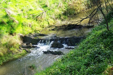
Photograph - Digital Image, Plenty River Greensborough, May 2014 -8, 18/09/2014
The Plenty River flows south from Mt Disappointment before meeting with the Yarra River at Rosanna. Early settlement in Greensborough was based around the Plenty River. These images were taken in the Greensborough area by Marilyn Smith Sept 2014.Digital copy of colour photograph.plenty river -
 Greensborough Historical Society
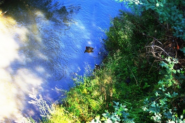
Photograph - Digital Image, Plenty River Greensborough, May 2014 -7, 21/05/2014
The Plenty River flows south from Mt Disappointment before meeting with the Yarra River at Rosanna. Early settlement in Greensborough was based around the Plenty River. These images were taken in the Greensborough area by Marilyn Smith May 2014.Digital copy of colour photograph.plenty river -
 Greensborough Historical Society
Photograph - Digital Image, Plenty River Greensborough, May 2014 -6, 21/05/2014
The Plenty River flows south from Mt Disappointment before meeting with the Yarra River at Rosanna. Early settlement in Greensborough was based around the Plenty River. These images were taken in the Greensborough area by Marilyn Smith May 2014.Digital copy of colour photograph.plenty river -
 Greensborough Historical Society
Photograph - Digital Image, Plenty River Greensborough, May 2014 -5, 21/05/2014
The Plenty River flows south from Mt Disappointment before meeting with the Yarra River at Rosanna. Early settlement in Greensborough was based around the Plenty River. These images were taken in the Greensborough area by Marilyn Smith May 2014.Digital copy of colour photograph.plenty river -
 Greensborough Historical Society
Photograph - Digital Image, Plenty River Greensborough, May 2014 -4, 21/05/2014
The Plenty River flows south from Mt Disappointment before meeting with the Yarra River at Rosanna. Early settlement in Greensborough was based around the Plenty River. These images were taken in the Greensborough area by Marilyn Smith May 2014.Digital copy of colour photograph.plenty river