Showing 171830 items
matching will street
-
 Port Melbourne Historical & Preservation Society
Photograph - 98, 99 & 100 Evans Street, Port Melbourne, Meredith Turnbull, Dec 1996
Meredith Turnbull photographed this series in 1996 to record the rapidly changing streetscape, which had already had a number of old houses replaced by concrete two-storey structures under the State government's urban consolidation policyFrom a series of 70 colour photos recording all buildings in Evans Street from Graham Street overpass to Ingles Street, as photographed from the railway reservation, by Meredith Turnbull in December 1996 - number 98, 99, 100House numbers noted on backbuilt environment - domestic, meredith turnbull -
Port Melbourne Historical & Preservation Society
Photograph - 102, 104 & 106 Evans Street, Port Melbourne, Meredith Turnbull, Dec 1996
Meredith Turnbull photographed this series in 1996 to record the rapidly changing streetscape, which had already had a number of old houses replaced by concrete two-storey structures under the State government's urban consolidation policyFrom a series of 70 colour photos recording all buildings in Evans Street from Graham Street overpass to Ingles Street, as photographed from the railway reservation, by Meredith Turnbull in December 1996 - number 102, 104, 106House numbers noted on backbuilt environment - domestic, meredith turnbull -
Port Melbourne Historical & Preservation Society
Photograph - 106, 108 & 110 Evans Street, Port Melbourne, Meredith Turnbull, Dec 1996
Meredith Turnbull photographed this series in 1996 to record the rapidly changing streetscape, which had already had a number of old houses replaced by concrete two-storey structures under the State government's urban consolidation policyFrom a series of 70 colour photos recording all buildings in Evans Street from Graham Street overpass to Ingles Street, as photographed from the railway reservation, by Meredith Turnbull in December 1996 - numbers 106, 108, 100House numbers noted on backbuilt environment - domestic, meredith turnbull -
Port Melbourne Historical & Preservation Society
Photograph - 129, 130 & 132 Evans Street, Port Melbourne, Meredith Turnbull, Dec 1996
Meredith Turnbull photographed this series in 1996 to record the rapidly changing streetscape, which had already had a number of old houses replaced by concrete two-storey structures under the State government's urban consolidation policyFrom a series of 70 colour photos recording all buildings in Evans Street from Graham Street overpass to Ingles Street, as photographed from the railway reservation, by Meredith Turnbull in December 1996 - number 129, 130, 132House numbers noted on backbuilt environment - domestic, meredith turnbull -
Port Melbourne Historical & Preservation Society
Photograph - 148, 150 & 151 Evans Street, Port Melbourne, Meredith Turnbull, Dec 1996
Meredith Turnbull photographed this series in 1996 to record the rapidly changing streetscape, which had already had a number of old houses replaced by concrete two-storey structures under the State government's urban consolidation policyFrom a series of 70 colour photos recording all buildings in Evans Street from Graham Street overpass to Ingles Street, as photographed from the railway reservation, by Meredith Turnbull in December 1996 - number 148, 150, 151House numbers noted on backbuilt environment - domestic, meredith turnbull -
Port Melbourne Historical & Preservation Society
Photograph - 154, 156 & 157 Evans Street, Port Melbourne, Meredith Turnbull, Dec 1996
Meredith Turnbull photographed this series in 1996 to record the rapidly changing streetscape, which had already had a number of old houses replaced by concrete two-storey structures under the State government's urban consolidation policyFrom a series of 70 colour photos recording all buildings in Evans Street from Graham Street overpass to Ingles Street, as photographed from the railway reservation, by Meredith Turnbull in December 1996 - number 154, 156, 157House numbers noted on backbuilt environment - domestic, meredith turnbull -
Port Melbourne Historical & Preservation Society
Photograph - 120, 122 & 123 Evans Street, Port Melbourne, Meredith Turnbull, Dec 1996
Meredith Turnbull photographed this series in 1996 to record the rapidly changing streetscape, which had already had a number of old houses replaced by concrete two-storey structures under the State government's urban consolidation policyFrom a series of 70 colour photos recording all buildings in Evans Street from Graham Street overpass to Ingles Street, as photographed from the railway reservation, by Meredith Turnbull in December 1996 - number 120, 122, 123House numbers noted on backbuilt environment - domestic, meredith turnbull -
 Linton and District Historical Society Inc
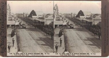
Stereograph, The Rose Stereographs, Melbourne, Sydney, Wellington and London, 12,924 Farewell Parade of the Australian Expeditionary Force, Coburg, Copyright 1914
One of two sets of stereographs donated by the O'Beirne family along with a stereoscope for viewing (Stereoscope is Registration no. 2014-51).Long line of soldiers marching along a street in Coburg Victoria. Street surface appears to be dirt with tram lines running through the centre. Spectators standing on one side of the street. Horsedrawn vehicles travelling in opposite direction of troops."12,924. THE FAREWELL PARADE OF THE AUSTRALIAN EXPEDITIONARY FORCE. The Troops / Passing through Coburg, Victoria."stereographs, australian expeditionary force -
 Wangaratta RSL Sub Branch
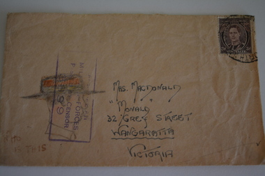
Work on paper - Envelope Art
One of series of illustrated envelopes, without letter, sketched by soldier/s during the second world war and sent to Mrs McDonald of Grey Street WangarattaVictoria's 2/24th Infantry Battalion was raised in Wangaratta in July 1940. They were welcomed with open arms by the local community as they rapidly built up their numbers. The people of Wangaratta adopted the Battalion and they became known as "Wangaratta's Own" because of the time the battalion spent in the town during its formative period prior to deployment overseas. Many of the soldiers maintained life long friendships with the people of Wangaratta. Even though the Battation was disbanded in 1946 members and their families return each year, in November, for a commemorative service at the 2/24th Battalion Memorial Wall at the Wangaratta Cemetery.Cream paper envelope with drawing of side profile of male wearing hat.Top right - postage stamp Left side - AIF Censor stamp Centre - Mrs M MacDonald "Monald" 32 Grey Street Wangaratta Victoria Australia Bottom left - "Who is this?" Rear - Red Cross ww2, envelope art -
 Kew Historical Society Inc
Plan, Melbourne & Metropolitan Board of Works : Borough of Kew : Detail Plan No.1302, 1910
The Melbourne and Metropolitan Board of Works (MMBW) plans were produced from the 1890s to the 1950s. They were crucial to the design and development of Melbourne's sewerage and drainage system. The plans, at a scale of 40 feet to 1 inch (1:480), provide a detailed historical record of Melbourne streetscapes and environmental features. Each plan covers one or two street blocks (roughly six streets), showing details of buildings, including garden layouts and ownership boundaries, and features such as laneways, drains, bridges, parks, municipal boundaries and other prominent landmarks as they existed at the time each plan was produced. (Source: State Library of Victoria)This plan forms part of a large group of MMBW plans and maps that was donated to the Society by the Mr Poulter, City Engineer of the City of Kew in 1989. Within this collection, thirty-five hand-coloured plans, backed with linen, are of statewide significance as they include annotations that provide details of construction materials used in buildings in the first decade of the 20th century as well as additional information about land ownership and usage. The copies in the Public Record Office Victoria and the State Library of Victoria are monochrome versions which do not denote building materials so that the maps in this collection are invaluable and unique tools for researchers and heritage consultants. A number of the plans are not held in the collection of the State Library of Victoria so they have the additional attribute of rarity.Original survey plan, issued by the MMBW to a contractor with responsibility for constructing sewers in the area identified on the plan within the Borough of Kew. The plan was at some stage hand-coloured, possibly by the contractor, but more likely by officers working in the Engineering Department of the Borough and later Town, then City of Kew. The hand-coloured sections of buildings on the plan were used to denote masonry or brick constructions (pink), weatherboard constructions (yellow), and public buildings (grey). The absence of buildings and or property in Kew facing the Yarra is the most notable feature of this plan. Walmer Street and its bridge stretched, then and now, from Studley Park Road to Victoria Street, Richmond. On the Richmond side of the Yarra, there was evidence in 1904 of industry (‘Wool shed’; Soap Works’) and entertainment (‘Skittle Alley’). In reality, another Plan (No.1303) shows Chinese Gardens bordering the Yarra on the Kew side and buildings in Young Street.melbourne and metropolitan board of works, detail plans, mmbw 1302, cartography -
 Warrnambool and District Historical Society Inc.
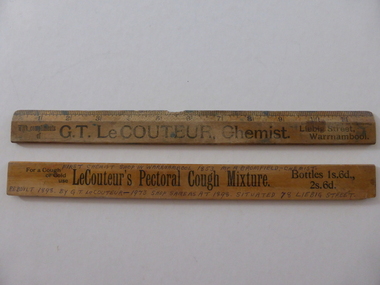
Ruler, G T Le Couteur Chemist x 2, Early 20th century
These rulers have been distributed by the Warrnambool chemist, George Le Couteur as advertising tools for his business. George Le Couteur operated a pharmacy at 78 Liebig Street, Warrnambool from 1896 to 1908. Born in Warrnambool in 1856 Le Couteur was educated at the Anglican-sponsored Warrnambool Common School No. 691 and then spent four years at Beechworth Grammar School. He was apprenticed to the Warrnambool chemist, Michael Ryan and then worked as a chemist in Kyneton and Melbourne. When he returned to Warrnambool he took over the business of Frank Uren in Liebig Street, building a second storey on to the building. He was very active in community affairs in Warrnambool. He left Warrnambool in 1908 to open a pharmacy in Hawthorn, Melbourne. When he retired in 1935 he was the oldest registered chemist in Victoria. The information hand printed on the back of one of the rulers has an historical inaccuracy in that J.A. Bromfield was not the first known chemist in Warrnambool. These rulers are of interest because of their connection to the pharmacy business of George Le Couteur He was a prominent person in Warrnambool in the 19th and early 20th centuries.These two oblong wooden rulers have imperial measurements ( to 12 inches). There is black printing on both sides advertising a Warrnambool chemist. One ruler is much stained and has a piece missing on the centre top edge. The other ruler has information on one side hand printed in black ink.‘With compliments of G.T. Le Couteur, Chemist, Liebig Street, Warrnambool’ ‘For a cough or cold use Le Couteur’s Pectoral Cough Mixture. Bottles 1s.6d., 2s.6d.’ ‘First Chemist Shop in Warrnambool 1853 Mr A. Bromfield – Chemist, rebuilt 1898 by G.T. Le Couteur – 1973 shop same as at 1898 situated 78 Liebig Street’ george le couteur, history of warrnambool -
 Ringwood and District Historical Society
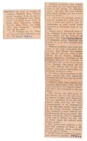
Newspaper - Clippings, Death of Miss Winifred Thomas of Alexander Avenue, Ringwood - June 1942
Death notice in local newspaper - Ringwood Mail 18/6/1942, and separate report of Miss Thomas being hit by a car driven by R. Naylor while crossing Station Street, Ringwood.Winifred Elva, beloved second daughter of H.O. and A. Thomas of Alexander Road Ringwood, and much loved sister of Grace,Rhys (deceased), Horace, Cornish, Rita, Elma and Gwen (Mrs Ron Westmore). Miss Thomas was well known in the district and for some years in business in Main Street, Ringwood. She was associated with church work including superintendent of the kindergarten at the Methodist Sunday school and the Junior Christian Endeavor. -
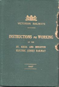 Melbourne Tram Museum
Document - Rule Book, Victorian Railways, "Victorian Railways Instructions re Working of the St Kilda and Brighton Electric Street Railway", 1926/27
Issued to employees of the VR St Kilda to Brighton electric street railway, superseding previous copies. The line closed in 1956. Note the spelling of the word "employe" with an accent over the e - an acceptable practice in Victoria at the time - a US based spelling. Book scanned into multiple parts. See Reg Item 3508 for a "Supplement to the Book of Instructions re the working of the St Kilda and Brighton Electric Street Railway, dated 1/1/1915", item 7518 for a June 1907 version, and 7580 for instructions issued in 1911.Demonstrates a Victorian Railway Rule book for electric tramways or Street Railways.Rule Book - 156 pages, five sewn sections within a green coloured Rexene heavy card with glued endpapers with the title "Victorian Railways Instructions re Working of the St Kilda and Brighton Electric Street Railway" and "1927" in gold block. Dated 1 June 1926. Has a table of contents and index - gives definitions - "trams" vs "street railways", general instructions, hand signs, working of cars, working of traffic over single and double line, staff and ticket systems, air brakes, permanent way, overhead, fares, appeals of employees against penalty and electric shock.Copy 3 has stamp of the "Westinghouse Brake Inspector" and "Lloyd Rogers" in ink on the inside front cover. On page 94 and 95 has notes in pencil about the air braking system - may have been for a following issue.trams, tramways, victorian railways, vr, st kilda brighton, rules, employees, safeworking -
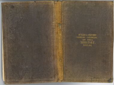 Bendigo Historical Society Inc.
Book - Butler & Stevens' Sandhurst, Castlemaine, and Echuca Directory 1865-66
Produced by John W Butler and George Stevens, relevant councils received copies of this directory in September 1865.Butler & Stevens' Sandhurst, Castlemaine and Echuca directory 1865-66 Produced in 1866. The directory has a brown fabric cover which has been embossed. The embossing has been worn down and is hard to see. The title is written in gold foiling in the centre of the cover. The directory contains 73 pages of address listings and an additional 24 pages of advertisements. Each town has had its addresses listed by street location and a separate listing of the same addresses listed in alphabetical order by name of occupant. Additional handwritten pages were placed inside the front cover (2 A4 pages folded in half). Written in pen. Inside the front cover and back cover written in pen: "E.A. Martin 17 Johnston Street Castlemaine" Title page (written in pen): "Miss Martin AMW Brotherton from Miss Martin 24th April 1951" Page 49 (written in pen) under Hargreaves Street - South to North right hand. "Dublin and Melbourne Portrait Rooms" and "-Now 102 23 Feb 1953 The slate steps up from the street, there in 1888, still there walked up there then + again today" Page 52 written in pencil next to the address for the Bank of New South Wales and the Bank of Australasia. "Completed 1861" Page 54 written in pencil under the F and G headers. "Miss Martin says had to (illegible) she meant Aitken's Street." "See Duke of Edinburgh (illegible)" Page 57 written in pencil under the S header. "Smyth '' of Hargreaves street" "Kate living at (illegible) 19/7/52" 19th century victoria, castlemaine, sandhurst, bendigo, echuca, butler & stevens, miss e a martin, amw brotherton -
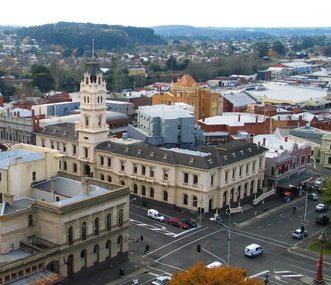 Federation University Historical Collection
Photograph, Ballarat Post Office and surrounds from the Ballarat Town Hall Tower, 2006, 2006
Around 1878 a series of photographs were taken from the newly completed Ballarat Town Hall tower. These photographs replicated the scenes of Ballarat around 135 years later.A series of digital images taken from the Ballarat Town Hall tower by Lisa Gervasoni. Buildings include the Ballarat Post Office, showing the newer buildings of the University of Ballarat's Arts Academy behind it. Streets shown at Sturt Street, Camp Street and Lydiard Street. One black and white image is also printed onto paper. university of ballarat, ballarat townscape, arts academy, camp street, ballarat post office, sturt street, lydiard street, ballarat streetscape -
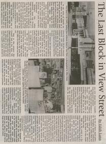 Bendigo Historical Society Inc.
Newspaper - JENNY FOLEY COLLECTION: THE LAST BLOCK IN VIEW STREET
Bendigo Weekly from Friday, August 17, 2001. The last block in View street - by Edith Lunn. The previous articles on View Street in its heyday as a shopping precinct dealt with the two blocks from Barnard Street to McKenzie Street. In the last article looks at the remaining block from McKenzie to View Point. The clip is in a folder.newspaper, bendigo, bendigo weekly -
 Bendigo Historical Society Inc.
Document - LONG GULLY HISTORY GROUP COLLECTION: LONG GULLY NAMES STREET BY STREET
Five pages of copies of residents of streets in Long Gully including Derwent Gully, Sparrowhawk and St Just Point. Numbers beside names are possibly street numbers. Street names have E Side, W Side, N Side or South Side. These pages have been photocopied from a street directory. Date unknown.bendigo, history, long gully history group, the long gully history group - long gully residents street by street, derwent gully, sparrowhawk, st just point -
 Bendigo Historical Society Inc.
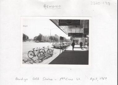
Photograph - LA TROBE UNIVERSITY BENDIGO COLLECTION: BENDIGO
A black and white photograph of McCrae Street Bendigo in April 1969. There are bicycles and cars parked in front of the businesses which include the Commonwealth Employment Service, Spero's Cafe a butcher and the Bendigo Advertiser. Bridge Street is leading off McCrae Street on the left hand side and the gold statue can be seen at the junction of the two streets. See 3320.100bendigo, streetscape, mccrae street, la trobe university bendigo collection, collection, bendigo, streetscape, mccrae street, bridge street, j.c. burnett, geoff pryor, photo, photos, photograph, photographs, history -
 Sunbury Family History and Heritage Society Inc.
Photograph, Former Yakka Factory
In the 1950s there was a move to bring some light industries into Sunbury. The large building in Barkly Street, which was used to make gloves and other items of clothing was taken over by the Yakka Company and boys shorts were made there. In the 1960s the Yakka Company moved to new and larger premises in Broadmeadows resulting of the closure of the Sunbury factory. A car park which services the business owners and employees from O'Shanassy Street now occupies the site.The Yakka Factory was one of the early manufacturing ventures to be started in Sunbury.A non-digital scanned copy of a coloured photograph of a large shed-like building with two utility trucks parked in the street in front of the building. There are some tall shrubs on either side of the building and a tall electric light pole on the RHS of the picture.He photograph has a narrow cream border.yakka factory, barkly street, manufacturing -
 Ringwood and District Historical Society
Plan - Proposed Ringwood East Railway Station, VR Ringwood-Croydon (Dublin Road) - 1923
Technical drawing of "Proposed Station At 16Mls 38Chs 89Lks (Dublin Road)" inluding boundary line, red shaded platform with station buildings, and green shaded possible future "up" track. Surrounding streets include Dublin Road, Patterson Street, and subsequent hand-written additions of Railway Avenue, Lawrence Grove, Stanley Avenue, Wenwood Street, and Lois Street. Land title details of Patterson Street properties mainly illegible.Scale: 40'=1". Possible future (platform) extension for 8 car trains (and) extension for 10 car trains. -
 Federation University Historical Collection
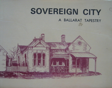
Book, Sovereign City: A Ballarat Tapestry, 1974
Hard covered book of 80 pages with a yellow dust jacket. Many sketches including Armstrong Street, Lydiard Street, Montrose Cottage Eureka Street, Lauderdale, Ballarat Railway Station. Bailey's Mansion, Former Ballarat Gaol, Ballarat Town Hall, Camp Street Police Station. Ballarat East Post Office, Ballarat Synagogue, Lal Lal blast furnace, Sovereign Hill, Mount Buninyong, Dana Street Primary School. non-fictionballarat, buildings, architecture, edward heffernan -
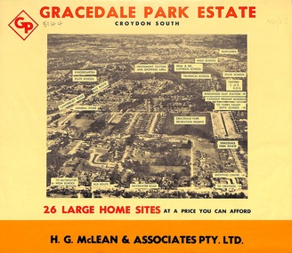 Ringwood and District Historical Society
Flyer, Land Sale Brochure, Gracedale Park Estate, Croydon South, Vic. circa 1968
Although the brochure advertises Gracedale Park Estate as Croydon South, the home sites and streets are in the 3135 postcode area, i.e. Ringwood East/Heathmont.Bi-folded orange coloured sheet with black print advertising sale of residential allotments, including subdivision features and local facilities.Sudivision includes Ringwood East streets - Gracedale Avenue and Raymond Court. Agent - H.G. McLean & Associates Pty. Ltd., 166 Canterbury Road, Heathmont. Telephone 870 3422, A/Hours 870 5879, 729 2809. -
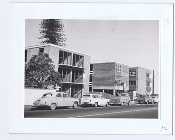 St Kilda Historical Society
Photograph, c.1964
Typical example of replacement from mansions to flats. Three storey walk ups, by three buildings. In the modern style. Brick.black and white photograph, mounted in good condition.Flats Barkly Street, site of former St Margarets, 56 Barkly Street, taken in 1964. Old house demolished and flats erected.' -
Glenelg Shire Council Cultural Collection
Photograph - Photograph - Julia Street, Portland, 1859
Vern Mc Callum CollectionDigital copy of a monochrome photo of Portland, N 1859 View of buildings on south side of Julia street, between Percy and Bentick streets.photography, vern mccallum, portland cbd -
 Eltham District Historical Society Inc
Photograph, Brougham Street, Eltham, early 1900s, 1900s
Colour photograph of a poor quality photograph (in album) of Brougham Street, Eltham looking east from near Susan Street, early 1900seltham, brougham street, wellington street, susan street -
 Eltham District Historical Society Inc
Photograph, M. North, Main Road, Eltham near Fitzsimons Lane Roundabout, Dec 1985, 1/12/85
Two colour photographs of Main Road, ElthamSouth between Falkiner Street and Bolton Street at the roundabout of Fitzsimons Lane, Eltham, Dec 1985Noted on 463B 'See 1934 small black and white snap of flooded bridge and the same two shops. This snap taken from same location, Dec 1985. Old Eltham Park on right of photo The two shops at left (Ansel and Muir) Road ahead crosses new bridge over the Diamond Creek, Eltham Main Road now dual highway, through Lower Plenty to this bridge'main road, eltham, eltham south, fitzsimons lane, round about, falkiner street -
 Federation University Historical Collection
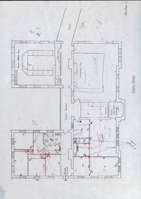
Building Plan, School of Mines Lydiard Street Administration Building, Late 1970s
Office spaces in SMB, Lydiard Street Administration Building at street level. Each of the five photocopies shows a different arrangement of the Council Room.ballarat school of mines, administration building, plans, lydiard street, offices -
Port Melbourne Historical & Preservation Society
Photograph - Walkthrough lane between Princes and Station Streets, Port Melbourne, Pat Grainger, 1998
Taken and annotated by Pat Grainger for the "Lurking in the Lanes" book project and finally donated to the PMH&P Society in 1998Four original colour photographs of walkthrough lane between Princes and Station Streets (one lead-off at Liardet with two into Station Street)built environment - domestic, engineering - roads streets lanes and footpaths -
Port Melbourne Historical & Preservation Society
Photograph - Station Street, Port Melbourne, 1907
Station Street Port Melbourne approximately 1907. Shows Emerald House on corner Station and Raglan Streets. Image was taken from postcard.built environment - domestic, station street, emerald house -
Port Melbourne Historical & Preservation Society
Photograph - Beach Street from demolition site of Housing Commission off Princes Street, Port Melbourne, Peter Libbis, 26 Dec 1990
Colour photograph looking toward Beach Street from housing commission site. Behind crane, corner of Rouse and Princes Streets. 26.12.1990built environment