Showing 123950 items
matching main-road
-
 Marysville & District Historical Society
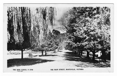
Postcard (Item) - Black and white postcard, Rose Stereograph Company, The Main Street, Marysville, Victoria, 1913-1967
A postcard in a series produced by the Rose Stereograph Company in Victoria, Australia as a souvenir of Marysville.A black and white photograph of Marysville's main street. This is now known as Murchison Street. This postcard was produced by The Rose Stereograph Company as a souvenir of Marysville.POST CARD The "Rose" Series/ De Luxe A Real Photograph/ Produced in Australia Published by the Rose Stereograph Co.,/ Armadale, Victoriamain street, murchison street, marysville, victoria, p. 2749, rose series postcard, postcard, souvenir -
 Stawell Historical Society Inc
Souvenir - Realia, The Main Street 2 Piece Ceramic Souvenirs
Souvenir Tea Set1 Ash Tray with coloured view of main street showing Post Office with Telegraph Pole and Post Office Hotel, Triangular, Chipped, 15 cm high, 14 cm at base. Egg cup with Main Street in Colour c1920's with Geo Mitchell Store.Royal Staffordshire Guaranteed English Bone China Made in England Crown Royal Grafton Bone China made in England Egg Cuptourism -
 Puffing Billy Railway
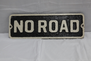
No Road - End of platform sign
Historic - Railway - No Road Plate Sign Historic - Railway - No Road Plate Sign No Road Plate Sign Long rectangular plate that has been painted black and white with the words "no road" written across it. made of cast metal"No Road"puffing billy, sign, plate, no road sign -
 Ballarat Heritage Services
Photograph, The Deserted Great Ocean Road at Apollo Bay during the Covid 19 Lockdown, 20/09/2021
During the Covid19 Pandemic lockdowns resulted in empty roads. Colour photographs of plaques commemorating the opening of the Great Ocean Road, 2020great ocean road, plaque, apollo bay, david mclaren, pandemic, covid19 -
 Ringwood and District Historical Society
Photograph, Wieland house at corner of Dickason Road & Canterbury Road on 30.9.1973
Wieland house at corner of Dickason Road & Canterbury Road on 30.9.1973. -
 Vision Australia
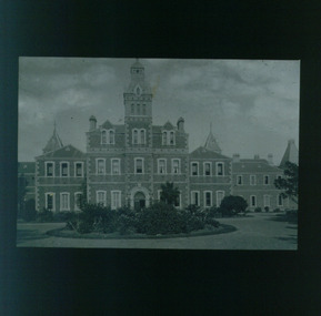
Slide - Image, Talma, Front view of St Kilda Road building, circa 1900
Lantern slide of RVIB taken from the front garden. A circular garden bed outside the main entrance is filled with flowering plants and bushes, and surrounded by a stone driveway. Around the building, bushes, vines and trees have grown. Possibly circa mid 1870 to 1890's, based upon size of trees.Lantern slide of St Kilda Road buildingroyal victorian institute for the blind, buildings -
 Eltham District Historical Society Inc
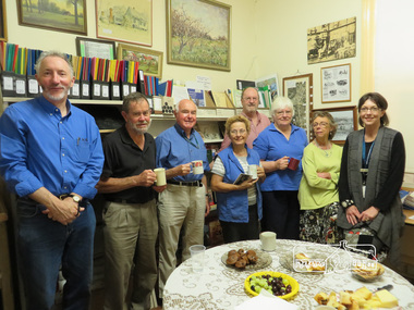
Photograph, Liz Pidgeon, Meeting at Eltham Local History Centre, 4 December 2014
Meeting of the Combined Nillumbik Heritage Groups, network which meets four times a year. Local History Centre, (Eltham District Historcal Society) 728 Main Road, Eltham L-R: Jim Connor (EDHS), Russell Yeoman (EDHS), Noel Withers (Greensborough Historical Society), Martha Wike (Andrew Ross Museum), Dennis Ward, Maureen Jones (EDHS), Sue Law (EDHS) and Michelle Zemancheff, Arts and Culture Coordinator Shire of Nillumbik. Photographed by Liz Pidgeon, Local and Family History Librarian, Yarra Plenty Regional LibraryThis photograph illustrates the interior of EDHS's Local History Centre at 728 main Road, Eltham prior to renovation and re-organisation in 2017. It also provides a snapshot of active volunteers and supporters in the Local History community within the Shire of Nillumbik in 2014Born Digitaleltham district historical society, greensborough historical society, jim connor, russell yeoman, dennis ward, noel withers, maureen jones, sue law, combined nillumbik heritage groups, local history centre, volunteers, supper, network -
 Eltham District Historical Society Inc
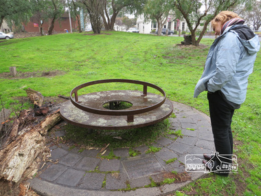
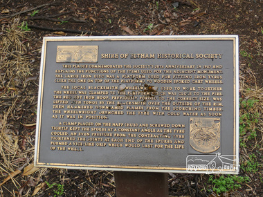
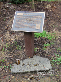
Photograph, Liz Pidgeon, Monument containing a time capsule in celebration of Victoria's 150th Anniversary and marking the location of the original centre of Eltham township, 21 June 2017, 21 June 2017
A walk around Little Eltham, 21 June 2017 Newsletter No. 175 July 2007 FORTY YEARS IN HISTORY The Society has been involved with a number of one off historical projects that have lasting outcomes. Perhaps the most significant is the monument and time capsule installed at the Eltham Community Centre site at the comer of Pitt Street and Main Road to commemorate Victoria's 150th anniversary. The monument based on a blacksmith's tyring plate was designed by artist Joh Ebeli. Beneath it is a time capsule containing items from 1985 and donated by Graham Beyer. It is to be opened in 2035.Born Digitalmain road, time capsule, monuments -
 Eltham District Historical Society Inc
Photograph, Liz Pidgeon, Monument containing a time capsule in celebration of Victoria's 150th Anniversary and marking the location of the original centre of Eltham township, 21 June 2017, 21 June 2017
A walk around Little Eltham, 21 June 2017 Newsletter No. 175 July 2007 FORTY YEARS IN HISTORY The Society has been involved with a number of one off historical projects that have lasting outcomes. Perhaps the most significant is the monument and time capsule installed at the Eltham Community Centre site at the comer of Pitt Street and Main Road to commemorate Victoria's 150th anniversary. The monument based on a blacksmith's tyring plate was designed by artist Joh Ebeli. Beneath it is a time capsule containing items from 1985 and donated by Graham Beyer. It is to be opened in 2035.Born Digitalmain road, time capsule, monuments -
 Sunbury Family History and Heritage Society Inc.
Photograph, Rosa McCall, Anderson Road, Sunbury, February 2014
The street in the photograph is Anderson Road, taken from the Darbyshire Street end and looking towards the SE to Gap Road. It was taken in February 2014. A non-digital coloured photograph of a street with a two storey house and three single storey homes.anderson road, sunbury, darbyshire road -
 Mt Dandenong & District Historical Society Inc.
Photograph, View From Corner of Doughty's Road and Barbers Road 1913
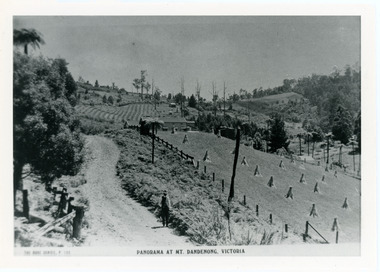
John Lundy-Clarke grew up in the Kalorama/Mt Dandenong area and later in life (1972-74) began to write a comprehensive history of the area working from an original settlement map in an effort to cover all areas. Taken c1913, this photograph gives a clear indication of where significant buildings were located in relation to one another. Barbers Road is running through the picture with the guest house 'Kia-Ora' , built by George Barber in the centre. High on the skyline on the left is the 'Mountjoy' guesthouse, indicating the location of The Gap, or FiveWays. The small 'boxy' house above 'Kia-Ora' is 'Iona' built by the Paynter family who also built 'Mountjoy'. The Jeeves property 'Kalorama' is to the right of 'Iona' and this is the area you now look to from the FiveWays Lookout. The man in the photo is wearing a trilby hat so is probably a Rose Series employee - a feature in many Rose Series postcards.Black and white photograph that is a copy of Rose Series Postcard # 156. A man can be seen walking down an unmade road with haystacks to his right. Buildings and crops can be seen on the hillsides. Handwritten inscription on reverse by John Lundy-ClarkeView from corner of Doughty’s and Barbers Road 1913. “Kia Ora” in centre Paynter’s “Iona” near center skyline above “Kia Ora” with “Kalorama” on its right and Peter’s hut of the time below it among orchard trees. “Mountjoy” is on left skyline. W. Haye’s home is centre left. Hay paddock is Barbers Lot 25 Village Settlement.kia-ora, iona, kalorama, mountjoy, guesthouse, guest house, barbers road, doughty's road, paynter, jeeves, george barber -
Glenelg Shire Council Cultural Collection
Photograph - Photograph - Main Breakwater construction, Portland, Sep-53
Port of Portland Authority ArchivesBack: Purple PHT Stamp - Print No 4/26 Neg No. 192 Date Taken 29.9.53 Main Breakwater looking towards shoreport of portland archives, main breakwater, construction, portland harbour, harbour development -
Ringwood and District Historical Society
Photograph, View of War Memorial and Main Street Ringwood, est >1928, c.1928
Construction of the clocktower was completed in 1928.View of War Memorial and Main Street Ringwood, tinted, est >1928. Small print 6.3cm x 8.5cm. -
 Mt Dandenong & District Historical Society Inc.
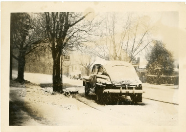
Photograph, Taxi in Main Street Olinda c1950, c1950
Snow scene in Main Street Olinda opposite shops c1950. Old taxi shown waiting at Taxi rank.olinda, main street, taxi, snow, snow -
 Eltham District Historical Society Inc
Slide, Looking south along Bonds Road towards intersection of Montpelier Drive, Lower Plenty, 18 July 1972, 1972
Water drainage work undertaken by Eltham Shire Council in Bonds Road, Lower Plenty outside the Martin property opposite Montpelier Drive, July 1972 Note blocked table drains.35 mm colour positive transparency Mount - Agfacolor Service (Blue)Bonds Road (Martin property) 12.10 pm 18.7.72bonds road, drainage works, eltham shire council, infrastructure, lower plenty, martin property, montpelier drive -
 Greensborough Historical Society
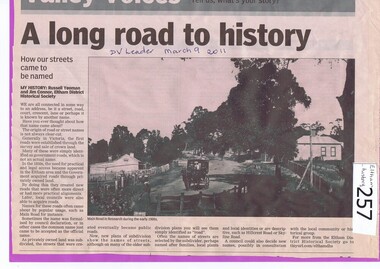
Newspaper clipping, A long road to history, 09/03/2011
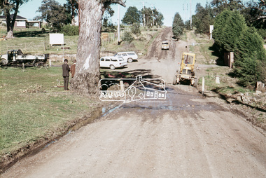
Records the origins of local street names.Explains how streets were named from the 1850s, with reference to Main Road Eltham to Research.A Diamond Valley Leader article on the history of street names in the local area. Illustration is a photograph of Main Road Research in the early 1900s. Written by Russell Yeoman and Jim Connor of Eltham District Historical Society.In pen "DV Leader March 9 2011."research, eltham, street names, main road -
 Whitehorse Historical Society Inc.
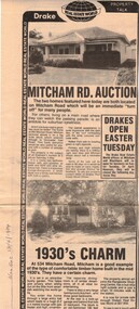
Newspaper, Mitcham Road auction, 01/04/1984,Nunawading
Advertisement for the sale of two homesAdvertisement for the sale of two homes, 265 Mitcham Road, Mitcham and 534 Mitcham road, Mitcham a 1930s timber home. Agent, drakes real estate. Photographs. Cutting from Nunawading Gazette, 18th April, 1984.Advertisement for the sale of two homesmitcham road, mitcham, no. 534, mitcham road, mitcham, no. 265, houses, drake & co. -
 Whitehorse Historical Society Inc.
Photograph, The Railway Crossing from Corner of Springvale Road & Station, 1/06/2009
One of a collection of photographs taken of the Nunawading Railway Station prior to the lowering of the railway line and building of the new railway station on the western side of Springvale Road so that the Springvale Road Rail Crossing can be eliminated.Black & white photograph of he precinct surrounding the Nunawading Station and the Springvale Road Railway crossing. This photograph is of the Railway Crossing from corner of Springvale Road & Station. See NP 3545 to NP3567for the complete set of photographsnunawading railway station, springvale road, nunawading, redevelopment of railway line/springvale road., station street nunawading -
 Stawell Historical Society Inc
Photograph, Robson & Gray Monumental Yards in Lower Main Street Stawell looking from Lower Main Street looking towards Barnes Street c1910
Robson & Gray Monumental Yards Lower Main Street Stawell. Photo taken from Lower Main Street looking towards Barnes Street c1910. Note house in background. Business was where Tyre Service Centre now is located.stawell -
Whitehorse Historical Society Inc.
Newspaper - Article, 519 Mitcham Road, Vermont, 8/03/1989
Article in Nunawading Gazette re sale of early 1900s home at 519 Mitcham Road, Vermont. One of the original homes in the area. In the early days the land was primarily used as a poultry farm.mitcham road, vermont, real estate, auctions -
 Eltham District Historical Society Inc
Slide, Pit on east side of Bonds Road, Lower Plenty, 18 July 1972, 1972
Water drainage work undertaken by Eltham Shire Council in Bonds Road, Lower Plenty outside the Martin property opposite Montpelier Drive, July 1972 Note rubbish excavated from pit.35 mm colour positive transparency Mount - Agfacolor Service (Blue)Bonds Road (Martin property) 12.10 pm 18.7.72bonds road, drainage works, eltham shire council, infrastructure, lower plenty, martin property, montpelier drive -
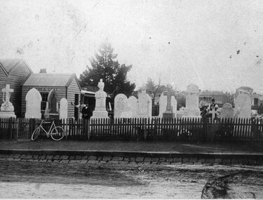
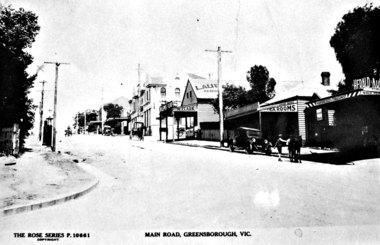 Greensborough Historical Society
Photograph - Digital image, Main Street Greensborough (Rose Series), 1930c
"Rose Series" postcard no P10661 Main Street Greensborough. The Tobacconist Shop on the front Right cf: Advertiser Hurstbridge 2/1/1925 page 3: W. J. Franklin Authorised News Agent Hair Dresser and Tobacconist. Best Brands of Tobacco, Cigarettes and Cigars. Billiards and Snooker. Two Alcock Tables. Golf Accessories Stocked. Main Road, Greensborough.Digital copy of black and white postcard.main street greensborough, rose series postcards -
 Kew Historical Society Inc
Photograph - Kew Main Drain, 1984
'Kew, Kew East, Balwyn & Balwyn North are located approximately 7km north east of Melbourne. Four main stormwater drains service the area flowing from south to north. Three of the drains: Deepdene Drain; Balwyn Drain & Glass Creek converge in Kew East just west of Burke Road at Kew High School before discharging into the Yarra River. The fourth drain, Kew Main Drain connects directly with the Yarra River to the West of Glass Creek.' The Kew Main Drain is a barrel drain that was created in the 1930s, and follows the route of the former Connor's Creek from the vicinity of Genazzano FCJ College to the Yarra River in East KewImportant and verifiable evidence of the construction methods used by the Melbourne & Metropolitan Board of Works in building the Kew Main Drain, before its reconstruction in c.1985.Original print colour positive photograph of the Kew Main Drain, provided on 14/12.84 to the Chief Engineer of the City of Kew, Ian Poulter, by the Supervising Engineer (Works), Southern and Eastern Drainage, Melbourne & Metropolitan Board of Works. The record includes an image of the reverse as well as the donation document from the MMBW."A84/1855-9 / 750mm council drain looking D/S [down stream] and across Parkhill Road. To be replaced with 1200 mm R.C.P. [reinforced concrete pipe] as part of MMBW Kew Main Drain reconstruction works"kew main drain, stormwater drains -- kew (vic.), connor's creek -- kew (vic.) -
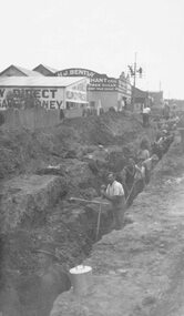 Ringwood and District Historical Society
Photograph, Maroondah Highway East, Ringwood- c1920's. Excavation for new water main
Black and white photograph (2 copies- 1 large, 1 small)Written on rear of backing sheet: "Digging trench for water main along Maroondah Highway." -
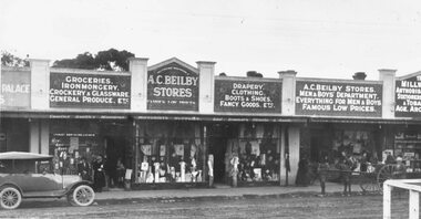 Ringwood and District Historical Society
Photograph, Pump, Brian, Maroondah Highway Central, Ringwood. Beilby's General Stores- Main St, 1925
Black and white photographTyped on backing sheet, "Beilby's General Stores- Main St, 1925. (Now Dimmeys) -
Tatura Irrigation & Wartime Camps Museum
Photograph, East Goulburn Main Channel, 1957
Taken by the photographer for Victoria State Rivers and Water Supply Commission.Large sepia photograph dry mounted on cream cardboard. 15" diameter concrete pylon, wooden scaffolding, with two men, left foreground, looking up into syphon mouth, one pointing right arm and index finger of right hand.Below Photo: "East Goulburn Main Channel / Construction of 15" Diameter Concrete Syphon" irrigation, goulburn, victoria state rivers and water supply commission, channel -
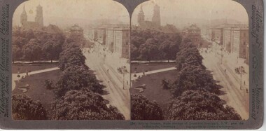 Linton and District Historical Society Inc
Stereograph, Underwood & Underwood, Publishers, Konis Strasse, Main Avenue of Beautiful Stuttgart, Copyright 1903
One of two sets of stereographs donated by the O'Beirne family along with a stereoscope for viewing (Stereoscope is Registration no. 2014-51).Stereograph of two black and white images. Images are of a cityscape. Left side of image has a line of trees along a roadway. Right side of image has tall buildings.(24) Konig Strasse, main avenue of beautiful Stuttgart, S.W. past the / Stittskirche, Germany.stereographs -
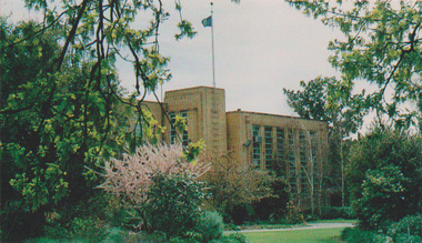 University of Melbourne, Burnley Campus Archives
Postcard - Colour print, Victorian College of Agriculture and Horticulture, Main Building VCAH Burnley 1991, 1991
Colour photograph made into a postcard, probably not the final version. "Horticultural College Centenary 1891-1991 Burnley." VCAH Logo and The covered with white sticker.Labelled, "Main Building, VCAH Burnley viewed from Burnley Gradens (sic), 1991."vcah, burnley, burnley gardens, 1991, centenary, postcard, administration building, main building, victorian college of agriculture & horticulture