Showing 2849 items matching "wests road"
-
 Ballarat Tramway Museum
Postcard, Murray Views, "Murray Views No. 27 Ryrie Street Geelong Vic", early 1950s
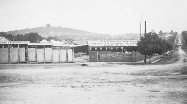
Postcard produced by Murray View of Gympie, of Ryrie St looking east from the west side of Yarra Street. A tram can be seen turning at Moorabool St. In the view are the Geelong Theatre, Cox, the T&G building, Preston Hotel and H F Richardson live stock sale and a taxis sign. Also shows the wood centre of the road poles.Yields information about the view of Moorabool St at Ryrie St early 1950s.Black and white Postcard divided back, unused. Card No. 27tramways, trams, geelong, ryrie st -
 Linton Mechanics Institute and Free Library Collection
Book - Novel, Wills, Chester, Arizona gold : a wild west novel, 1958 (Copyright)
192 p. : yellow cover, section of original dust jacket pasted to front. Title and author's name printed on spine.fictionfiction, westerns, chester wills -
 Ringwood and District Historical Society
Photograph, Maroondah Highway, Ringwood. Looking west from Warrandyte Road - 1965
... Maroondah Highway, Ringwood. Looking west from Warrandyte... Highway, Ringwood. Looking west from Warrandyte Road - 1965 ...Black and white photograph (2 copies)Typed under photograph: "Main Street, looking west from Warrandyte Rd. 1965". -
 Ringwood and District Historical Society
Document - Department of Lands and Survey, Wire Netting Branch, Melbourne, Victoria, Application for Vermin-Proof Fence Certificate - L.J. Mills vs John Collins, Grandview Grove, Ringwood, Victoria - 1939
Photocopied file of corresponence and documentation relating to a claim by L.J. Mills, Nurseryman, that adjoining property owner, J. Collins, Farmer, assists with replacement of a vermin proof wire netting dividing fence destroyed by 1939 bushfire. File includes 1939 and 1940 detailed property inspection reports by Vermin and Noxious Weeds Branch, Lands Department, Lilydale, describing land use in the area and signs of vermin activity. Application approved 18th April, 1940. Appeal lodged by Mr Collins disallowed in May, 1940. File closed June, 1940 with Departmental suggesion that Mr Mills consider further legal action through a Solicitor as fence had still not been wire-netted. TRANSCRIPTS: Vermin & Noxious Weeds Inspection Reports "19/9/1939 (To) Superintendent (Department of Lands and Survey, Melbourne) Re L.J. Mills application for Vermin Proof Fence. I called on Mr Mills yesterday 18th instant in connection with this matter. Mr Mills has a flower farm and claims that rabbits and hares are damaging his flowers. He showed me a bed of carnations which he stated were being damaged by rabbits. There was evidence of some leaves being nipped off, but I am unable to say whether this is due to rabbits or grubs. Very little if any real damage is being done. The property is netted on the east and south boundary and on half the north and west boundary. The surrounding country is undlating and fairly steep in places. The land to the east across Grandview Avenue (sic) is all planted out in old established orchards and well cultivated. Cleared grass land adjoins the south boundary and bush land adjoins the north and west boundaries. I walked over a large area surrounding Mr Mills land and never saw any rabbits or hares or any indications of rabbits. This locality is not rabbit infested and very little wire netting is being used. I do not consider that a vermin proof fence is necessary between these allotments. - Jas H Allison (Inspector, Vermin and Noxious Weeds Branch, Lands Department, Lilydale)." Follow up report following renewal of application for Certificate by Mr Mills, citing rabbits causing considerable damage to his flowers. He laid poison and obtained 9 carcases and stated that there is evidence of rabbit infestation from the adjoing land. "19/3/1940 (To) Mr Hannah (Superintendant, Department of Lands and Survey, Melbourne) Re L.J. Mills, Grandview Grove Ringwood, Lot 4 Grandview Estate Pt CG20 Ph of Warrandyte. I interviewed Mr Mills at his home on 15th inst. He showed me carcases of rabbits which he stated had been poisoned on his land. In places young plants had been nipped off apparently by rabbits. I made an inspection of adjoining properties and found one live burrow close to Mr Mills northern boundary. There were scratches and other evidence of rabbits on land north and west of Mr Mills property. In view of the present evidence of rabbits I consider that a vermin proof fence is now necessary to protect the flowers grown by Mr Mills. His land is netted on whole of east and south boundary and half way on west and north boundary. The adjoining land on west and north boundaries is owned by Mrs Linda Collins and John Collins resp of Brysons Road East Ringwood. - Jas H Allison (Inspector, Vermin and Noxious Weeds Branch, Lands Department, Lilydale)." -
 Ballarat Tramway Museum
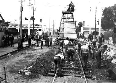
Photograph - Geelong Tramway - relaying tram tracks in Aphrasia St., Newtown
Relaying tram tracks at the eastern end of Aphrasia St., Newtowwn, looking east. The location is immediately west of the Pleasant St. intersection, soon after Aphrasia St. was extended from Pleasant St. to Pakington St., so that the three sharp curves for trams into Retreat Road, Pleasant St., and then Aphrasia St., were reduced to one, from Pakington into Aphrasia St. May 1914. Note that sleepers are being used in the construction, as seen in items 9271 and 9214, with tie bars and continuous concrete about 50cm wide under each rail. The overhead is being worked on in two ways; safely with the horse drawn tower wagon, or less so by ladder.,Black and white print on paper.GRS710/.25/1/7 and 25-7 written on the reverse in pencil. The No. 1 in a circle written on reverse in ink.geelong tramway, relaying tram tracks in geelong, sleeper and concrete tram track base -
Port Melbourne Historical & Preservation Society
Photograph - Various photos related to John James GILCHRIST, John Gilcrist, 1940s - 1950s
From John Gilcrist via Janet Bolitho13 photos from John GILCHRIST showing his father, John James GILCHRIST, at Station Pier and Princes Pier, a view from the Shrine of Remembrance, Centenary Bridge, and his father and mother, Eileen Mary GILCHRIST at their home at 16 McCormack Street Port Melbourne .01 - Princes Pier, Taroona, Port Hobart .02 - View from Shrine overlooking Albert Park Lake .03 - Between piers .04 - Princes Pier at night .05 - From Station Pier West finger pier .06 - House at 16 McCormack Street. (No. 12 McCormack Street also shown) .07 - Centenary Bridge1949-50 .08 - Outside 16 McCormack Street, showing Singer car. (Nos. 22, 24 & 26 McCormack Street also shown) .09 - John and Eileen Gilcrist in backyard .10 - South side of house at 16 McCormack Street .11 - South side of house at 16 McCormack Street .12 - Photo of Edwards Park .13 - East side of house at 16 McCormack Street Refer also to hand drawn plan of house and outbuildings at catalogue no. 2763piers and wharves - station pier, piers and wharves - princes pier, built environment, transport - roads, mccormack street, john gilchrist, john james gilchrist, mary eileen gilchrist -
 Phillip Island and District Historical Society Inc.
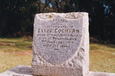
Photograph Album, Kodak, Phillip Island Cemetery, c 1990
The Album was compiled by Nancy McHaffie late 1990's, with the assistance of Edith Jeffery's, with her book "Garden of Memories" and extensive knowledge of Phillip Island. The Cemetery lies back from the road and is surrounded by Manna Gums, rare Peppermint Gums, Blackwoods and other native trees. In all 25 acres of land were set aside as Crown Land in the land settlement of 1868. There are 6.2 acres of wetlands near the cemetery entrance.a) Grave stone of Eliza Coghlan b) Grave stone of Eliza Coghlan with Edith Jeffery standing beside. Eliza was born in West Heath, Ireland. She arrived in Australia on the immigrant ship "Thomas Arbuthnot". She came to Phillip Island as house-keeper to James Duffus and served for 40 years. She was often seen walking to Cowes, about five miles, carrying a heavy turkey. The main road to the cemetery was named in her honour. It has been claimed that Eliza with the oldest subject of Queen Victoria. She died in February 1910, at the age of 113.phillip island cemetery, nancy mchaffie, edith jeffery -
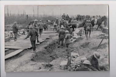 Wangaratta RSL Sub Branch
Postcard, 1917
From the album of WWI soldier William West (1268) of the 29 Infantry Battalion, 5th Pioneers Battalion. This collection of postcards, photographs and clippings were sent between William and his family and loved ones during the years he was on active service. See also 207 and 220. Postcard with a black and white photograph of soldiers constructing a roadway at the front. Handwritten message on the back.album, photo album, newspaper clippings, postcard, wwi, photograph, soldier, the front, road, construction -
Lakes Entrance Historical Society
Book, Loney Jack, Wrecks Along the Great Ocean Road, 1967
Account of many of the shipwrecks which occurred on the west coast of Victoria from 1839 to 1964. Some information on lighthouses, rocket crews,and cliff rescue squads. Index of ships, glossary of rigging terms.maritime history -
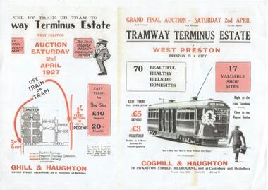 Melbourne Tram Museum
Document - Photocopy, Ron Scholten, "Tram Terminus Estate - West Preston", Original 1927
Photocopy A4 size of a foolscap document, missing left hand edge of an advertisement titled "Tram Terminus Estate - West Preston". Auction dated 2/4/1927. Has an image of tram L 104 with a destination of West Preston, 70 sites, 5 shop sites, Gilbert Road and Regent Street. Sales by Coghill and Haughton of Swanston St Melbourne Gives fares from Regent Station and by tram.trams, tramways, auctions, real estate, advertisements, new tramway, regent, west preston, tram 104 -
 Eltham District Historical Society Inc
Photograph - Digital Photograph, Alan King, Alistair Knox Park, Eltham, 2008
Alistair Knox Park, an oasis of peace and beauty. Covered under National Trust of Australia (Victoria) Landscape Significance and Heritage Overlay, Nillumbik Planning Scheme. Published: Nillumbik Now and Then / Marguerite Marshall 2008; photographs Alan King with Marguerite Marshall.; p173 It is hard to imagine that the Alistair Knox Park, an oasis of peace and beauty beside busy Main Road, Eltham, was once the township’s rubbish dump. It was only in the 1970s that the tip was transformed into this beautiful six hectare space, which later earned it a National Trust Landscape classification. Before its life as a dump, the area was used for small farms. Thanks largely to the foresight and efforts of local environmental builder Alistair Knox, the park was designed sympathetically with the character of the wider Eltham landscape. Then, appropriately, the park was named after Knox, who was an Eltham Shire Councillor from 1971 to 1975 and Shire President in 1975. The park designers were four major forces in the urban bush landscape garden –Knox, landscape designer Gordon Ford, artist Peter Glass and landscaper Ivan Stranger. The National Trust citation for the park, originally called Eltham Town Park, includes the Eltham railway trestle bridge and the Shillinglaw Cottage. The citation states ‘the semi-natural setting of the parkland provides a landscape which is evocative of the history of the area’. Manna Gums (Eucalyptus viminalis) and Candlebarks (Eucalyptus rubida) are significant features. Most of the park’s construction was directed by Bob Grant, Superintendent of the Parks and Gardens Department for the Eltham Shire Council. First plantings occurred in Arbour Week in 1973, then the lake and botanic area were completed in 1975, with Federal Government funding, and the toilet block in 1978. Bounded by the Eltham railway line, Panther Place, Main Road, Bridge and Susan Streets, the park is in a valley about a kilometre wide overlooked by steep hills at the east and west. The Diamond Creek flows through it and the picturesque historic timber trestle railway bridge edges the north. Informal plantings of Australian indigenous and native species in open and undulating grassed settings blend with the natural landscape of the Diamond Creek to the west. The bush-style plants, particularly around the creek, balance with open lawns, paths and a cascade flowing from a small lake to another below. A footbridge over the creek leads to the park’s west. The park includes an adventure playground and barbecue areas. The park stands on part of the land bought from the Crown in 1851 by Josiah Holloway, who subdivided it into allotments and which he called Little Eltham. Most of the land was subdivided into residential lots, but the creek valley, on which the park stands, was subdivided into farm-size lots, used mainly for orchards and grazing. One of the earliest owners was John Hicks Petty, who in 1874 bought a plot from Holloway. Other families who owned properties in that area, included Rees, Clark, Waterfall, Graham, Hill and Morant. In 1901 the railway was built through the area. Jock Read, an Eltham resident since around 1920, remembers several farms in the 1920s and ’30s that occupied the site of today’s park. A poultry farm, which extended from present day Panther Place, was owned by the Gahan family. Next to that farm was another for grazing cattle owned by Jack Carrucan. Beside this was land owned by John Lyon. A doctor lived beside this, and at the north-west corner of Bridge Street and Main Road stood a memorial to the soldiers who died in World War One, which was later moved to the RSL site. Mr Read also remembers other farms and orchards west of the creek In the early 1960s the Eltham Council began buying these farms and in the late 1960s turned the areas east of the Diamond Creek into a garbage tip. When this was filled above the creek’s flood plain, the tip was moved to the west of the creek.This collection of almost 130 photos about places and people within the Shire of Nillumbik, an urban and rural municipality in Melbourne's north, contributes to an understanding of the history of the Shire. Published in 2008 immediately prior to the Black Saturday bushfires of February 7, 2009, it documents sites that were impacted, and in some cases destroyed by the fires. It includes photographs taken especially for the publication, creating a unique time capsule representing the Shire in the early 21st century. It remains the most recent comprehenesive publication devoted to the Shire's history connecting local residents to the past. nillumbik now and then (marshall-king) collection, alistair knox park, eltham -
 Eltham District Historical Society Inc
Photograph - Digital Photograph, Alan King, Diamond Creek, Barak Bushlands, Eltham, 2008
A habitat corridor and it strengthens the community. Published: Nillumbik Now and Then / Marguerite Marshall 2008; photographs Alan King with Marguerite Marshall.; p185 Barak Bushlands lie west of the Diamond Creek on the corner of Falkiner Street and busy, noisy Main Road. They form part of an important habitat corridor linking the Yarra River to the Kinglake National Park.1 Manna Gums, tawny frogmouths and platypuses are some of the indigenous plants and animals that have made their home there. The bushlands are the result of more than nine years of hard work by the local community with the Nillumbik Council, to transform a degraded flood plain into this refuge of natural beauty. In 1997, shortly after moving into the new Riverside Estate on Falkiner Street, Eltham, several residents noticed the sorry state of the Diamond Creek and surrounding area. Part of it was used as a cow paddock and although small patches of vegetation survived, the area was infested with weeds, rabbits, rubbish and drainage from the housing estate. At various times the 4.4 hectares had been used as a market garden and for shire stock piles. The residents began to restore the area by revegetating land along the Diamond Creek. In 1998 they established the Friends of the Diamond Creek Falkiner Street Reserve2 and 35 families joined from the 90-house Estate. Carolyn Mellor, as the Friends’ Land Manager, undertook a four-year horticulture course to guide this massive project for a volunteer organisation. Since 1999, she has been the Friends’ President. In 1999 the Friends urged the Nillumbik Council to undertake a feasibility study into establishing a wetland system and urban forest. Work began in 2002 with Nillumbik Council funding the project, supplemented by government grants. The Friends also received grants from Melbourne Water and Parks Victoria. Aided by the Friends and other community members, the Council created the Barak Bushlands consisting of a forest, a wetland, a bridge, a path and open space. The beautiful wetland treats most of the estate’s stormwater runoff. Storm water is filtered through plants in the wetland ponds then is released slowly into the billabong, before flowing into the Diamond Creek. The wetland also helps to minimise flooding and the improved water quality provides a flora and fauna habitat. The Friends and other volunteers planted more than 27,000 plants, more than one third of which they grew from seeds they collected at Lower Eltham and Wingrove Parks. Eltham High School students planted thousands of these through a Year Eight program introduced for this purpose. Other groups who assisted were: Green Corps, local Scouts and Guides – 2nd Montmorency, 1st Diamond Creek and 1st Eltham Cub Packs, Eltham College students, Eltham East Primary School, Landcare members, Eltham Lions Club and the Eltham Baptist Church. To maintain enthusiasm for the mammoth task, the Friends and other volunteers ‘adopted’ trees to water and wrote their names on the stakes. In 2004, to recognise the area’s original occupiers, the reserve was named Barak Bushlands. William Barak, who lived from 1824 to 1903, was the last chief of the Yarra Yarra tribe of the Wurundjeri-willam people. Traces of these original inhabitants remain in scar trees (bark sections removed to make a shield or canoe). That same year the Friends’ group was a finalist in the prestigious Federal Government, Banksia Environmental Awards. The Friends have also participated in Clean Up Australia, removing tonnes of rubbish and regularly testing the billabong, wetland and creek, for pollutants. For years the Friends, together with the Australian Platypus Conservancy, have tagged, measured and checked the health of platypuses from the Diamond and Mullum Mullum Creeks. With Latrobe University the Friends have conducted night walks to view owls, possums, bats and sugar gliders. Challenges for the council and the Friends continue with a large rabbit population, some vandalism, weed eradication and maintenance. However, thanks to this community effort, locals can now escape confined urban living on small blocks of land and enjoy the beauty of indigenous plants and animals. Working together has also strengthened the local community,This collection of almost 130 photos about places and people within the Shire of Nillumbik, an urban and rural municipality in Melbourne's north, contributes to an understanding of the history of the Shire. Published in 2008 immediately prior to the Black Saturday bushfires of February 7, 2009, it documents sites that were impacted, and in some cases destroyed by the fires. It includes photographs taken especially for the publication, creating a unique time capsule representing the Shire in the early 21st century. It remains the most recent comprehenesive publication devoted to the Shire's history connecting local residents to the past. nillumbik now and then (marshall-king) collection, barak bushlands, diamond creek (creek), eltham -
 Eltham District Historical Society Inc
Photograph - Digital Photograph, Marguerite Marshall, Eltham Retirement Centre (Judge Book Memorial Village), Diamond Street, Eltham, 23 October 2006
Thousands of elderly people at this centre have contributed much. Published: Nillumbik Now and Then / Marguerite Marshall 2008; photographs Alan King with Marguerite Marshall.; p161 Thousands of elderly people, who have contributed much to Nillumbik and beyond, have made their home in the treed Eltham Retirement Centre. The centre, which opened in 1956, has housed the disadvantaged in particular, through good times and hard, including floods, fire and even burglaries. As part of the Melbourne Citymission, a non-denominational Christian organisation that cares for people living with disadvantage, the centre was built to celebrate 100 years of the Melbourne Citymission’s work since 1854. Standing on a former poultry farm called Willandra (Still Waters), the centre includes independent units, hostel, nursing home accommodation and a Day Therapy Centre, which is available for non-residents as well. Despite being metres from the busy Main Road and railway station, the centre provides a quiet oasis on 6.8 hectares bordered by the Diamond Creek to the west, and the railway line to the east. The centre was originally named Judge Book Memorial Village after Judge Clifford Book, Deacon of the Collins Street Baptist Church. Book was also President of the Baptist Union of Victoria and Grand Master of the Masonic Lodge. He was so respected that, at his death, several Pentridge prisoners asked to attend his funeral. In 1993 the centre’s name was changed to clarify that it was part of the Melbourne Citymission. However Judge Book’s name continues in the Judge Book Memorial Garden, opened in 2006. The Diamond Creek has flooded the centre several times, however rarely causing serious damage. Volunteer Alan Field recalls a flood in 1974 when the resident manager Reverend Norman Pearce and his wife, were rescued by boat from their home with their budgerigar. On February 3, 2005, when the creek almost flooded Metzner Hall, 35 ambulances evacuated residents to nearby nursing homes, hostels and local homes. Residents were also evacuated during the 1965 bush fire, but fortunately a change of wind direction saved the centre. Residents have also endured several burglaries. Despite much rebuilding and modernisation over the years, traces of the original farmhouse remain in the administration areas. In 1991 the Willandra Hostel was built and in 2001 the Eltham Lodge Nursing Home with each room having a garden view. Several buildings are named after people who have given special service to the centre including the Norman Pearce Day Hospital after general manager and pastor Rev Pearce. Metzner Hall was named after the Metzner family who had been active in the auxiliary since it began and had donated generously to the Recreation Hall fund.3 A bridge was named after Sister Lila Murray who had worked at the village for 42 years in various capacities including as relieving manager. Field remembers Sister Murray as ‘the Mother Teresa and soul of what the village aspired to, with love and care’. Since 1957 the Eltham Auxiliary, later called the Residents’ Association, has worked to improve the residents’ quality of life by volunteering and raising funds. An outstanding volunteer, Field, who was drawn to the centre in 1971 with his wife Chris, has held positions on the early Eltham boards, auxiliaries and Residents’ Association. Much of his work has been supporting people with no family and those of limited means. He says he and his wife look at their work as having shared ‘our lives with amazing people’. The wealth of experience and wisdom in the Retirement Village has benefited many people, including local school children. Residents have acted as proxy grand-parents at local schools, by assisting small learning groups or telling their life stories. Conversely, students from local schools have visited to perform, or to assist in programs like craft activities. Resident Val Bell, whose mother Rose Bullock lived at the centre before her, sums up the centre’s most important attribute for her: ‘The Christian care. They could not be more caring’.This collection of almost 130 photos about places and people within the Shire of Nillumbik, an urban and rural municipality in Melbourne's north, contributes to an understanding of the history of the Shire. Published in 2008 immediately prior to the Black Saturday bushfires of February 7, 2009, it documents sites that were impacted, and in some cases destroyed by the fires. It includes photographs taken especially for the publication, creating a unique time capsule representing the Shire in the early 21st century. It remains the most recent comprehenesive publication devoted to the Shire's history connecting local residents to the past. nillumbik now and then (marshall-king) collection, diamond street, eltham, eltham retirement centre, eltham retirement village, judge book memorial village -
 Ringwood and District Historical Society
Photograph, Maroondah Highway Central, Ringwood. Laying water main in Main Street, 1935
Black and white photographImage shows excavator digging trench for water main on Main Road (Maroondah Highway. Towards the west, near the corner of Warrandyte Road. The Ringwood Stationmaster's house is on the left, Bamford's timber yard, Coffee Palace and other shops on right. -
 Warrnambool and District Historical Society Inc.
Booklet - Booklet Collection: City of Warrnambool Tourist Guides, Collett, Bain and Gaspar, Warrnambool
This is a collection of sixteen tourist guides dating from the mid 1970's to 2013. These contain listings of businesses, accommodation, eateries and events in Warrnambool and district. They also include maps of Warrnambool and surrounds, advertising and photographs of various attractions. While mainly covering Warrnambool a small number of the guides cover the South West Region. These directories have mainly been published by the Warrnambool City Council and are a selection of the types of information provided to visitors at the Tourist information centre during this time period.These tourist guides give snapshots of the City of Warrnambool for the years covered and will be useful for research.[.1] An 8 page paper booklet with black printing and a black & white photo of the pond at the Botanical Gardens on the front cover. [.2] two photocopied A4 black and white pages from the book "On the Trail" K Winser 1956 (Main Roads of Australia) [.3] A trifold colour brochure with a stylised map of the coast on the yellow and blue front cover. The inside has stylised colour drawings on Warrnambool attractions. The rear cover has coloured photographs of bush, Liebig Street and Fletcher Jones gardens [.4] A trifold black and white brochure with a black line drawing of a whale on the front cover. [.5] A trifold white card with mauve printing. The front cover has a line drawing of the former Timor Street post office and a map of businesses and landmarks in Timor Street. The reverse side contains a brief history of Warrnambool. [.6] A 98 page stapled booklet with a foreword by Vanda Savill. There are 4 pages of coloured photographs. The remainder are black and white photographs. The front cover is purple with white writing in the lower third. There is an outline of the coast and five colour photographs of district attractions. The inside middle page has a map of the Western wonderland region. The content covers towns in this area. Content relating to Warrnambool is in the last six pages. [.7] Twelve loose photocopied black and white pages. The front cover has the Warrnambool Premier Town 1988-1991 logo and a photo of a Southern Right Whale and calf. The bottom right hand corner has a Standard Warrnambool logo. [.8] 44 page booklet printed with blue ink. The staples have been removed. The glossy front cover has blue printing with a coloured photo of Flagstaff Hill Maritime Village pond. The centre pages has a fold out map of the City of Warrnambool. The rear cover has photos of The Twelve Apostles and Hopkins Falls. [.9] 4 loose photocopied pages with Warrnambool Library and Corangamite Regional Library Service Warrnambool City Library black ink stamps. The front page line drawing illustrations of Warrnambool attractions [.10] A single sheet of glossy white paper folded in half to make four pages. The front page has a Warrnambool premier town logo 1979-1982 and blue printing and a visitor survey. [.11] A conference pack of light card folded to make a pocket containing three brochures, a shipwreck coast tourist directory and a Australian Heritage Parks Association conference program dated 24 to 27 May 1992. The front cover of the pack has green writing over a stylised upward arrow. There is a City of Warrnambool logo in the top right hand corner and two film strips diagonally across the cover containing photographs of Warrnambool. The rear cover has a coloured Warrnambool Premier Town logo. [.12] A 63 page stapled booklet with coloured photographs of Warrnambool. The front cover has black writing on white background. There is a coloured photograph of Flagstaff Hill in the middle of the cover and a Warrnambool City and Visit Victoria logos on the lower edge. The middle pages has a coloured of the city of Warrnambool with an inset map of Allansford. [.13] A single large sheet of white paper folded in ten to make a brochure. The front cover has black printing. The rear cover has a purple ink stamp for the City of Warrnambool Tourist Information Centre. When folded out the reverse side has a green, grey and white map of the South West Region of Victoria. [.14] A 48 page colour booklet on glossy paper. The front cover has white writing on a blue background and includes photographs of the Twelve Apostles, the Promenade walk, Flagstaff Hill and a southern right whale's tail. The rear cover has photographs of The Twelve apostles, a passenger train from Melbourne passing the Lake Pertobe playground, and a rural scene. There is white writing and a white Warrnambool City logo on a blue background. The centre pages have a stylised green and blue map of the city of Warrnambool. [.15] A 48 page colour booklet on glossy paper. The front cover has white writing over colour photographs of two people at a lookout, Flagstaff Hill, three southern right whales and a child at the Lake Pertobe playground. The lower edge has blue upper case writing on a white background. The rear cover has a colour photograph of the Twelve Apostles. The lower white border on the rear covers has a a blue and green City of Warrnambool logo and blue writing. The centre pages have a stylised green and blue map of the city of Warrnambool. [.16] A 64 page colour booklet on glossy paper. The front cover has black writing on a black background and there is a photograph of a southern right whale's tail. The lower edge has the Warrnambool City and Visit Victoria Logos. The centre pages have maps of Warrnambool and surrounds. [.1] This week in Warrnambool Vol 2 No. 5 Thurs 1st Feb. For the time of your life [.2] Warrnambool Way [.3] Warrnambool The Holiday Host on the South West Coast with compliments City of Warrnambool and Warrnambool Chamber of Commerce [.4] MMI Insurance presents Whales Giants of the Deep Whale Watcher's Logbook Warrnambool [.5] Warrnambool History began in Timor Street [.6] Western Wonderland Tourist Association [.7] A Premier Arrow Tour of Warrnambool Victoria's Premier Town Australia's Southern Right Whale Nursery [.8] Warrnambool The Heart of Victoria's Great Southwest Visitor's Handbook [.9] What to see in Warrnambool Victoria's Premier City 1979-1982 [.10] Win a Free Holiday & $200 Cash in Victoria's Premier Town [.11] Advancing Warrnambool together! [.12] Great Ocean Road Warrnambool Official Visitor Guide [.13] Tourist guide to the South West Region Victoria All it needs is you [.14] Warrnambool visitor guide 2005 the great ocean road experience attractions accommodation entertainment dining [.15] Warrnambool Visitor Guide 2006 the great ocean road experience Attractions Accommodation Entertainment Dining [.16] Official Visitors' Guide Warrnambool Victoria Australia Discover the Great Ocean Road warrnambool, warrnambool tourist guides -
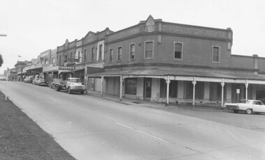
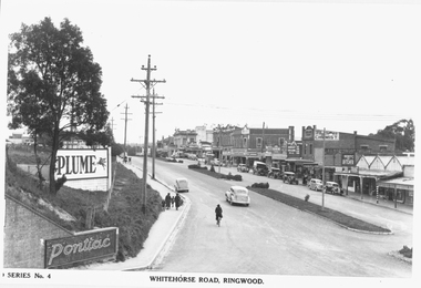 Ringwood and District Historical Society
Photograph, Maroondah Highway Central, Ringwood. Whitehorse Road looking west from Warrandyte Road. c1930's
... looking west from Warrandyte Road. c1930's.... Road looking west from Warrandyte Road. c1930's. Photograph ...Black and white photograph (2 copies)Inscribed on photograph: "Series No 4. Whitehorse Road, Ringwood. Image shows shops on north side of road from Warrandyte Road railway bridge to Ringwood Street. -
 Ringwood and District Historical Society
Photograph, Maroondah Highway Central, Ringwood. Bamford's Timber Yard, c1920
... Written on back of photograph: "Bamford, west corner...Written on back of photograph: "Bamford, west corner ...2 copies of photograph (1 black and white, 1 smaller sepia)Written on back of photograph: "Bamford, west corner of Warrandyte Road and Main Street". -
 Ringwood and District Historical Society
Photograph, Maroondah Highway Central, Ringwood. Main Street shops looking west from Warrandyte Road, c1950's
... looking west from Warrandyte Road, c1950's.... Street shops looking west from Warrandyte Road, c1950's ...Newspaper clipping of black and white photograph.Image shows shops on north side of Whitehorse Road between Warrandyte Road and Adelaide Street. -
 Ballarat Tramway Museum
Photograph - Set of four black and white negatives of Ballarat trams, Warren Doubleday, 20-4-1968
Photos 25-4-69, of: .1 - Ballarat 17 at Stones Corner with Caltex Service Station in the background. Tram leaving Main Road before joining Bridge St. .2 - No. 28 running from Bridge Street into Sturt Street with a "Trotting at Bray Raceway Tonight" Auxillary board. Tram has the destination of Gardens via Sturt St West. In the background are the Big W and the Dickins Store. .3 - Tram 43 on "0" road at the SEC Ballarat Depot. .4 - Tram 13 at the Gardens Loop in Wendouree Parade. Tram has an ANA Hospital and Medical Benefits (Australian Natives Association) Advertising Board.Yields information about the operation of the Ballarat tramway system that was operated by the State Electricity Commission of Victoria.Set of four black and white negatives of Ballarat Tramways, 120 size. ballarat, trams, tramways, sturt street, tram 17, main road, bridge street, tram 28, bray raceway, dickins, big w, tram 13, ana health, wendouree parade, gardens loop, depot, tram 43, stones corner, caltex -
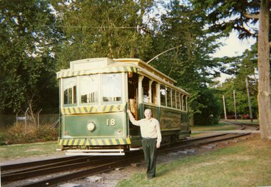 Ballarat Tramway Museum
Photograph - Colour Photograph/s - set of 12, Jenny Puls, 13/03/1996 12:00:00 AM
Set of twelve colour photographs of the derailment of Tram No. 18 on the depot fan (2 and 3 road points) on 13 March 1996. Included within the cataloguing sheet are a copy of the report to the traffic manager and the envelope from Frank Puls. Photographs by Jenny Puls, on Kodak paper. The report is a photocopy of the original held by the Traffic Manager. .1 - Frank standing by No. 18 .2 - No. 1 end showing derailed wheel .3 - From the south side .4 - Close up photo showing marks on rail from the wheel. .5 - From the north side .6 - Dave Macartney locating jacks .7 - Looking west towards the depot .8 - From the northside during rerailing .9 - Alan Snowball holding towbar with 661 in the background .10 - 18 and 661 .11 - Being coupled to No. 38 .12 - Being towed back on with Alan Snowball observing. On rear of each photo in stamped in black ink "13 March 1996"accidents, btm, derailments, depot fan, tram 18, tram 661, tram 38 -
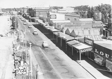
 Ringwood and District Historical Society
Photograph, Maroondah Highway Central, Ringwood. Block Emporium, corner of Adelaide Street and Whitehorse Road, c1960
Black and white photographImage is looking west from Adelaide Street towards the Town Hall. -
 Ringwood and District Historical Society
Photograph, Maroondah Highway Central, Ringwood. Looking west from Warrandyte Road, 1960
... Maroondah Highway Central, Ringwood. Looking west from... west near Pratt Street. Warrandyte Road on right. Black ...Black and white photograph (2 copies)Written on back of photograph: "Maroondah Highway looking west near Pratt Street. Warrandyte Road on right. -
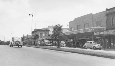 Ringwood and District Historical Society
Photograph, Maroondah Highway Central, Ringwood. Looking west from near Adelaide Street, c1948
Black and white photograph (2 copies)Image shows shops on north side of Whitehorse Road towards Town Hall. -
 Ringwood and District Historical Society
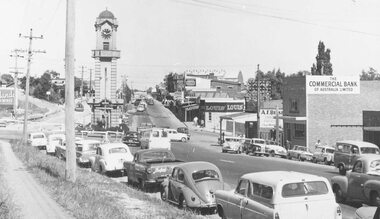
Photograph, Maroondah Highway Central, Ringwood. Looking west from Warrandyte Road, 1960. Taken from clock tower
... Maroondah Highway Central, Ringwood. Looking west from... west from clock tower, 1960. Road being reconstructed." Black ...Black and white photograph (2 copies)Written on back of one copy: "Maroondah Highway looking west from clock tower, 1960. Road being reconstructed." -
 Melbourne Tram Museum
Ephemera - Timetable, The Met, Set of 12 Tram Timetables, produced by The Met, 1987 - 1989
Set of 12 Tram Timetables, produced by The Met for various routes, yellow cover with a green top band, multi fold horizontal sheet, giving a route map, description, notes, time points, information contact details and types of tickets (Neighbourhood and Travelcards) and where they could be purchased. .1 - Route 3 - East Malvern - City via Balaclava Road - replaced by bus 377 on Sundays - dated 14/9/1987 .2 - Route 5 - Malvern Burke Road - City via Wattletree Road - 19/6/1988 .3 - Route 6 - Glen Iris - City via High St - 19/6/1988 .4 - Route 19 - North Coburg - City via Elizabeth St including connecting bus service to Gowrie and Upfield stations - 14/11/1988 .5 - Route 42 - Mont Albert - City - 15/8/1988 .6 - Route 48 - North Balwyn - City via Flinders St - 31/10/1988 .7 - Route 55 - West Coburg - Domain Interchange via William St - 11/2/1987 .8 - Route 57 - West Maribyrnong - City via North Melbourne - Route 357 bus replaces tram on Sunday - 27/8/1989 .9 - Route 59 - Airport West - City via Essendon - 27/8/1989 .10 - Route 64 - East Brighton - City via Hawthorn Road - 14/9/1987 .11- Route 70 - Wattle Park (Elgar Road) Princes Bridge via Swan St - 31/10/1988 .12 - Route 86 - Bundoora - City via West Preston - 15/8/1988 Full Image of .4 added 9/4/17 following a query about route 19 timetables - see image i5.trams, tramways, timetables, tickets, tram services, route 3, route 5, route 6, route 19, route 42, route 48, route 55, route 57, route 59, route 64, route 70, route 86 -
 Melbourne Tram Museum
Ephemera - Timetable, The Met, Set of 3 The Met - Metropolitan Transit, 1983 - 1984
Set of 3 The Met - Metropolitan Transit folded sheet timetables, printed on white paper, gives a map, time points, route description, notes and contact details. Note the contact times have been altered in hand writing. Folded by the half by half method. .1 - Routes 1 and 2 - South Melbourne Beach via Swanston St and Route 4 - South Melbourne Depot - City - October 1984. .2 - Routes 10 and 11 - West Preston via Collins St and route 13 - via Latrobe St - dated May 1984. .3 - Route 15 and 16 - St Kilda Beach - City via Swanston St - July 1983.trams, tramways, timetables, tickets, tram services, la trobe st, latrobe st, route 10, route 11, route 13, route 15, route 16, route 1, route 2, route 4 -
 Melbourne Tram Museum
Ephemera - Timetable, The Met, Set of 18 Tram Timetables, produced by The Met, 1986 - 1988
Set of 18 Tram Timetables, produced by The Met for various routes, white cover with two green, multi fold horizontal sheet, giving a route map, description, notes, time points, information contact details and types of tickets (Neighbourhood and Travelcards) and where they could be purchased. .1 - Route 3 - East Malvern - City via Balaclava Road - replaced by bus 377 on Sundays - dated 14/9/1987 .2 - Route 5 - Malvern Burke Road - City via Wattletree Road - 19/6/1988 .3 - Route 6 - Glen Iris - City via High St - 19/6/1988 .4 - Route 8 - Toorak - City via Toorak Road - 19/6/1988 .5 - Route 19 - North Coburg - City via Elizabeth St including connecting bus service to Gowrie and Upfield stations - 11/3/1987 .6 - Route 55 - West Coburg - Domain Interchange via William St - 11/2/1987 .7 - Route 57 - West Maribyrnong - City via North Melbourne - Route 357 bus replaces tram on Sunday - 1/12/1986 .8 - Route 59 - Airport West - City via Essendon -1/12/1986 .9 - Route 64 - East Brighton - City via Hawthorn Road - 14/9/1987 .10 - Route 67 - Carnegie - City via Glenhuntly Road - 14/9/1987 .11 - Route 69 - Kew (Cotham Road) - St Kilda Beach via Glenferrie Road - 19/6/1988 .12- Route 72 - Camberwell - City via Malvern Road - 19/6/1988 .13 - Route 75 - East Burwood - City via Flinders St - 15/2/1988 .14 - Route 78, Route 79, North Richmond - Prahran via Chapel St and North Richmond - St Kilda Beach via Chapel St - 13/7/1987 .15 - Route 82 - Footscray Moonee Ponds via Highpoint City and Route 223 bus replacement for Saturday afternoon and all day Sunday. 3/8/1987 .16 - Route 88 - Bundoora - City via Preston .17 - Route 96 - East Brunswick - St Kilda Beach via Bourke St City - 22/11/1987 .18 - Route 111 - Royal Exhibition Buildings - Port Melbourne via Bourke St City - 20/12/1987. (2nd copy added 1/4/20201( .19 - Route 600 - St Kilda - Middle Brighton via Elwood - 1/12/1986 Full Image of .5 added 9/4/17 following a query about route 19 timetables - see image i6.trams, tramways, timetables, tickets, tram services, route 3, route 5, route 6, route 19, route 55, route 57, route 59, route 64, route 8, route 67, route 69, route 72, route 75, route 78, route 78, route 79, route 82, route 88, route 86, route 111, route 600 -
 Melbourne Tram Museum
Ephemera - Timetable, Melbourne & Metropolitan Tramways Board (MMTB), Set of 14 MMTB Bus timetables, Jul. 1969
All July 1969 - no route numbers shown. .1 - Box Hill - Heidelberg - Templestowe .2 - East Kew - Box Hill - Doncaster .3 - Deer Park - Sunshine Park - Sunshine - Footscray - City .4 - Fishermen's Bend - City .5 - Williamstown Rd - Footscray Railway Stn - Ballarat Rd .6 - Garden City - City .7 - La Trobe University - Northland - West Heidelberg - City .8 - Box Hill - North Blackburn .9 - Bulleen - North Kew - City .10 - Clifton Hill - Elsternwick .11 - Box Hill - East Doncaster - Mitcham - Ringwood .12 - Deer Park - Sunshine Park - Sunshine - Footscray - City - Saturdays and Sundays - printed on pink paper. 13 - Warrandyte - Donvale Post Office - City 14 - Warrandyte - Park Orchards, Ringwood.Yields information about MMTB Bus services July 1969Set of 14 MMTB Bus timetables, folded sheets, providing timetables for specific routes, day of week giving information on tram times at specific time points, route map, sections and fares and organisation address - 616 Little Collins St. Melbourne.trams, tramways, timetables, tickets, bus services, fares, mmtb -
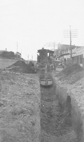
 Melbourne Tram Museum
Newspaper, "Building a Tramway Loop", Apr. 1926
Newspaper cutting from an unknown Melbourne newspaper with "Building a Tramway Loop", with a photo of track construction in Victoria St between Swanston St and Elizabeth St to enable tramcars to be moved between depots and for special traffic. Photo taken looking west, just shows the curve into Swanston St. Timeline history gives the opening of 31/5/1926trams, tramways, victoria st, track construction, swanston st -
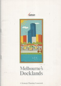 Melbourne Tram Museum
Document - Report, Ministry for Planning and Environment, "Melbourne's Docklands - A Strategic Planning Framework", 1989
Report - 32 A4 pages centre stapled colour printed on gloss paper, titled "Melbourne's Docklands - A Strategic Planning Framework", dated August 1989. Has a foreword by Tom Roper Minster for Planning and Environment. The report with a table of contents looks at the development of the Victoria Docklands area to the west of the railway yards. Has a good colour photograph of the area. Includes public transportation links using trams.trams, tramways, docklands, planning, melbourne, new track, public transport