Showing 10429 items
matching sites
-
 Kew Historical Society Inc
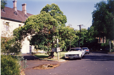
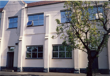
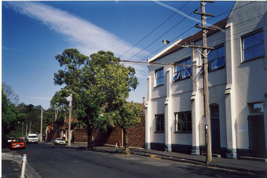
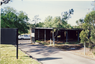
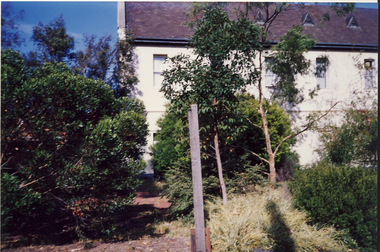
Photograph, Former Convent of the Good Shepherd, Abbotsford, c.1990
The former Convent of the Good Shepherd at Abbotsford includes ecclesiastical, residential, educational and utility buildings constructed during the late nineteenth and twentieth centuries on a bend of the Yarra River. In 1975 the site was purchased by the Victorian Government as a higher education campus. A proposed redevelopment of the site in the late 1990s led to a community-based heritage battle which resulted in 2004 in the transfer of the convent site south of St Heliers Street to the Abbotsford Convent Foundation for community use. (Source: Heritage Victoria)This photograph is part of a series taken c.1990 by the photographer Rick Lowell. It was taken before the heritage campaign to preserve the site for community use.Colour snapshot of a part or section of the Former Convent of the Good Shepherd, Abbotsfordabbotsford convent, convent of the good shepherd, abbotsford (vic.) -
 Kew Historical Society Inc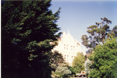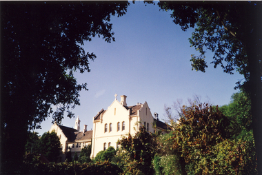
Photograph, Former Convent of the Good Shepherd, Abbotsford, c.1990
The former Convent of the Good Shepherd at Abbotsford includes ecclesiastical, residential, educational and utility buildings constructed during the late nineteenth and twentieth centuries on a bend of the Yarra River. In 1975 the site was purchased by the Victorian Government as a higher education campus. A proposed redevelopment of the site in the late 1990s led to a community-based heritage battle which resulted in 2004 in the transfer of the convent site south of St Heliers Street to the Abbotsford Convent Foundation for community use. (Source: Heritage Victoria)This photograph is part of a series taken c.1990 by the photographer Rick Lowell. It was taken before the heritage campaign to preserve the site for community use.Colour snapshot of a part or section of the Former Convent of the Good Shepherd, Abbotsfordabbotsford convent, convent of the good shepherd, abbotsford (vic.) -
 Rutherglen Historical Society
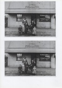
Image, c1902-1903
Two identical black and white photographs of the Yourn Cash Grocer Shop, with J H Yourn & Family standing in front of shop. Inscription on the back of each image varies slightly.On back of top photo: "J H Yourn & Family | Taken North Prentice, circa 1902 | Located immediately South of North Prentice School Site | on the Chair James Norman | John Henry Yourn | Irene (King) | Winnie (Herd) | Alice (Withers) | Florence (Nash) | Gladys (Grant)" On back of bottom photo: "J H Yourn & Family | Taken at North Prentice, circa 1903 | Located south of the North Prentice School site | in the chair James Norman | John Henry Yourn | Irene (King) | Winnie (Herd) | Alice (Withers) | Florence (Nash) | Gladys (Grant)"yourn cash grocers, yourn family, john henry yourn, james norman yourn, irene king, winnie herd, alice withers, florence nash, gladys grant, grocery -
 Federation University Historical Collection
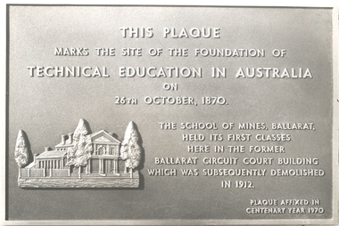
Photograph, Ballarat School of Mines Centenary Plaque, 1c970
The Ballarat School of MInes is a predecessor institution of Federation University Australia.This plaque marks the site of the foundation of technical education in Australia on 26th October, 1870. The School of Mines, Ballarat held its first classes here in the former Ballarat Circuit Court Building which was subsequently demolished in 1912. Plaque affixed in centenary year 1970ballarat school of mines, plaque, former ballarat circuit court, centenary, anniversary -
 St Kilda Historical Society
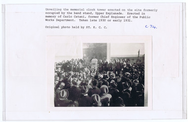
Photograph, Carlo Catani Memorial Clock Tower unveiling, c1930, c. 1930-1931
Upper Esplanade, St Kildablack and white photograph, original, mounted, good conditionUnveiling the memorial clock tower erected on the site formerly occupied by the bandstand, Upper Esplanade. Erected in memory of Carlo Catani, former Chief Engineer of the Public Works Department. Taken late 1930 or early 1931. Original photo held by St.K.C.C' c.74 -
 Ringwood and District Historical Society
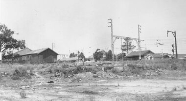
Photograph, Ringwood Coolstore site after clearing in 1963, 1963
Black and white photographWritten on back of photograph: "Site of Cool Store- 17.11.63. Old goods shed to the left, new shed to the right. Kendall's house (old hospital) in background. Corner of Whitehorse Road and Watirna Road. Photographed by Brian Pump, 36 Knaith Road, Ringwood East. -
 Ringwood and District Historical Society
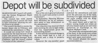
Newspaper, Scrapbook Clipping, Library Collection, Ringwood, Victoria, `
``Newspaper clipping from "The Mail"5-12-95", P 5. Depopt will be subdivided. Maroondah Council will subdivide the former Ringwood Depot site and sell it. The council last week passed amendment 1.38 to rezone the land to light industrial, allowing the subdivision to go ahead. It would not reveal how much it expected for the land because of the tender sale process.` -
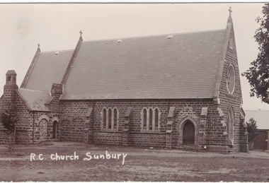 Sunbury Family History and Heritage Society Inc.
Postcard, R.C. Church Sunbury
On 17th January 1856, two acres of land was granted for the building of a school and church on that site in Macedon Street. A small temporary building was erected on the site and on 13th December 1864 the foundation stone was laid for the new stone church which was known as 'Our Lady of Mount Carmel'Is one of the oldest churches to be established in Sunbury.A non-Digital post card photograph of the Roman Catholic Church in Sunburyour lady of mount carmel catholic church, macedon street, sunbury -
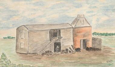 Phillip Island and District Historical Society Inc.
Water Colour Sketch, 1960's
Donated by N. M. & J. D. Archibald. April, 1973.Colour 18.5 Sketch done from old photograph. Chicory Kiln - Jansson Family, approximately 1880's. It was built on the land next to the Caravan Park. The only remains of it now are a few bricks on the site. The sketch shows Mr Frank Jansson as a young boy in the doorway. Galvanized iron structure was sold to Mr N Cleeland.local history, illustrations, agriculture buildings, historic, chicory kiln, water colour sketch, jansson family, n & j archibald, jean archibald -
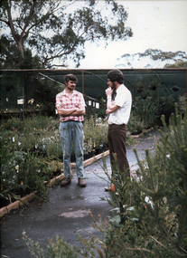 University of Melbourne, Burnley Campus Archives
Photograph - Colour prints, Photograph Collection of Potential Careers
Photographs mounted on heavy cardboard for a display. (1) Nursery with 2 men, "Nursery Trade" handwritten on reverse. (2) Nursery with man and child, "Nursery Trade" handwritten on reverse. (3) Construction site with 1 man, "Landscape Design" handwritten on reverse. (4) Park with 3 men, "Parks and Gardens" handwritten on reverse. (5) Private gardennursery, men, children, parks, gardens -
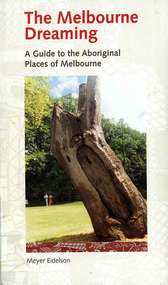 Victorian Aboriginal Corporation for Languages
Book, Meyer Eidelson, The Melbourne dreaming : a guide to the Aboriginal places of Melbourne, 1997
This guide shows Melbourne?s Aboriginal places so that people using it can gain easy access to and a greater knowledge of them. Important historical events occurred at some of them. Others are Archaeological sites where there are still physical remains of Aboriginal activity before settlement. Locations have been mapped and Melways references and maps are included.maps, b&w illustrations, colour illustrations, colour photographs, word listswoi wurrung, wurundjeri, boon wurrung, kulin, yarra yarra, yarra river, werribee river, bunjil, waa, moieties, maribyrnong, sacred sites -
 Hume City Civic Collection
Photograph, 21/04/2005
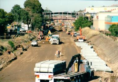
This photograph was taken during the upgrade of the Bendigo Railway line at Sunbury Station. The upgrade took twelve months to complete and during that time bus services replaced the trains.A coloured photograph of construction on the site of the Sunbury Railway Station. The photograph has been taken from the Macedon Street bridge looking south towards the station and the pedestrian bridge over the railway tracks. On the tracks the old railway lines have been removed and storm water pipes are being put into position before the new lines are to be laid.railways, bendigo line, railway stations, bridges, sunbury railway station, george evans collection -
 Phillip Island and District Historical Society Inc.
Photograph (item) - Mutton Bird Egging on Phillip Island, 1905
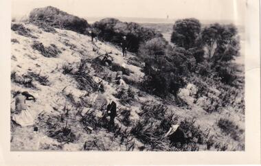
Photograph taken at The Narrows Rookery on Phillip Island. Field Naturalists' Club Excursion to Phillip Island to see Mutton Bird Egging.Mutton Bird Egging on P.I. about 1905mutton bird egging. the narrows phillip island. the narrows rookery. j. gliddon. a.d. hardy. v. mchaffie. -
 Port Melbourne Historical & Preservation Society
Photograph - Redeveloped Joshua Bros distillery, Port Melbourne, Feb 2006
Photographic images of properties in Port Melbourne. Image may have been taken by a PMHPS member or scanned from a past resident or taken for real estate sale purposes. Pickles Street and Rouse Street corner. Images of redeveloped Joshua Bros distillery site as apartments (ID complex) with retained bottle images on walls. Feb 2006built environment - domestic, pickles street, rouse street -
 Port Melbourne Historical & Preservation Society
Photograph - Two exterior views of Woodruff's Superior Dairy, corner Bridge and Derham Streets, Port Melbourne, 1987
From the Woodruff family archives, images of Woodruff's Superior Dairy at Bridge and Derham Streets. A4 lasercopy of two exterior views of dairy a) main building b) loading platform c) newspaper article 26/11/1987 Emerald Hill Standard and St Kilda Times, referring to new residential development on Woodruff siteDetails on typed labelsindustry, business and traders - dairies, woodruff's superior dairies -
 Ballarat Tramway Museum
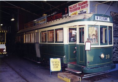
Functional Object - Tramcar, Duncan and Fraser, SECV Tram No. 39, 1914
Modified Max Traction bogie tram formally with drop ends, a centre combination. Modified by BTPS to be used as Display area. No. 2 end removed and stored, No. 2 end floor removed and sides removed, truck only remains. Other truck stored off site. Tram No. 39 See Destination Eaglehawk, Destination Citytrams, tram 39 -
 Whitehorse Historical Society Inc.
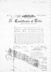
Document, Certificate of Title, 19/07/1918
Photocopy of Certificate of Title Vol. 4156 Folio 831198 for 43 acres Fronting on Canterbury Road near Mitcham Road, being part of Crown Portion 124, Parish of Nunawading, County of Bourke in the name of James Harley Malcolm, 19/7/1918. Last subdivision dated 22/5/1926- current site of Glenburnie Roadland subdivision, malcolm, james harley, mitcham road mitcham, glenburnie road mitcham, canterbury road mitcham, various surnames -
 Canterbury History Group
Ephemera - 20 McGregor Street Canterbury, 1/10/2000 12:00:00 AM
Real estate advertisement for the sale by auction of "Grosvenor" 20 McGregor Street Canterbury on Saturday 4 November 2000. Includes coloured photographs of the interior and exterior of the house and floor and site plans. A note by Robin Kelly on the flyer indicates that the property was sold before the auction for $615, 000. Also included is an advertisement from a newspaper of the auction.canterbury, mcgregor street, grosvenor, victorian style -
 Whitehorse Historical Society Inc.
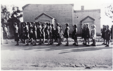
Photograph, Mitcham Guides
Mitcham Guides outside Hall in Britannia Street, Mitcham. Since demolished in the same frenzied activity that resulted in the redevelopment of Britannia Street and environs including the Junior Primary School site, Angling Club, Barelli's bakehouse, stable and the Salvation Army 'Citadel'. Many fine young women passed through the 'Scout Hall' as Mitcham's Guides and Brownies.guide groups, mitcham guide hall, britannia street, mitcham -
 City of Moorabbin Historical Society (Operating the Box Cottage Museum)
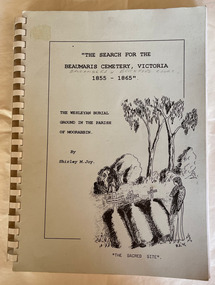
Book - Family History, Joy, Shirley, The Search For The Beaumaris Cemetery Victoria 1855--1865 : The Wesleyan burial ground in the Parish of Moorabbin, 1995
A history of the Beaumaris Cemetery and who is buried there and the subdivision of the Wesleyan church.vii, 92 leaves : ill., facsims., 1 plan, ports. A large spiral bound book with a soft cover detailing the early burial sites in the Beaumaris Cemetery.The front cover is white with a drawn picture of three graves and a girl in a long dress standing beside them also on the cover is the The Wesleyan Burial Ground in the Parish of Moorabbin.non-fictionA history of the Beaumaris Cemetery and who is buried there and the subdivision of the Wesleyan church.beaumaris, cheltenham, graves, burials, cemetery, registrar's records, subdivision, wesleyan. -
 Port Melbourne Historical & Preservation Society
Drawing - Various Port Melbourne locations, Brian Cleveland, 1990s
Brian Cleveland taught art to Swinburne students from the 1970s to 1990s and sketched and recorded iconic areas of the city that were scheduled to vanish or be seriously altered. The Port Melbourne drawings were predominantly done in the 1990sSeventy-two (72)) pencil drawings (some with watercolour washes) by Brian Cleveland. Sites include: Centenary Bridge (including demolition) ; ships ; Princes Pier ; Station Pier ; structures and cranes on piers ; cable tram sheds ; London Hotel ; foreshore views ; Beacons (leading lights) ; kiosks ; Missions to Seamen building: railway stations.built environment, built environment - civic, piers and wharves - princes pier, piers and wharves - station pier, engineering - bridges, brian cleveland, centenary bridge, missions to seamen -
 Ballarat Tramway Museum
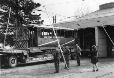
Photograph - Black & White Photograph/s, The Courier Ballarat, 21/09/1971
Yields information about the despatch of the scrubber tram to the TMSV at Bylands and how arrangements were made to lift the overhead in order to move the truck out of the depot yard.Black and White copy photograph of a newspaper photograph taken by The Courier - photo taken 21/9/1971, published 22/9/1971 of the Scrubber car being loaded for the TMSV site at Bylands. Shows how the tram was loaded onto the truck, and the overhead raised to clear the truck. See Reg Item 3334 for the actual Newspaper cutting. Second Copy as the Ballarat Courier stamp on rear.tramways, trams, tmsv, scrubber tram, transport, tram disposal, depot, tram scrubber -
 Melbourne Tram Museum
Ephemera - Ticket/s, Tramway Museum Society of Victoria (TMSV), Set of six tickets issued by the TMSV for the operation of the horse tram, Oct. 1980
Set of six tickets issued by the TMSV for the operation of the horse tram on 1 and 2/11/1980, as part of the Prahran Festival. Has an advert for National Mutual Permanent building society of the rear and the details of the TMSV's Bylands site. Green - child - 2601 and 2602 Yellow adult - 00009 and 00010 Pink adult - 4009 blue adult - 006009trams, tramways, prahran, tmsv, horse tram, chapel st, tram 1015 -
 Wodonga & District Historical Society Inc
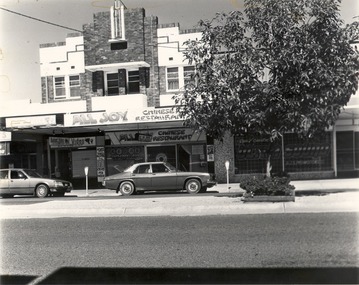
Photograph - Codling Collection O1 - High Street East - All Joy Chinese Restaurant, 1980s
Miss Olive Codling was a Foundation Member and a Life Member of the Wodonga Historical Society. Many of her prize-winning photos are held in the Society Collection. She also held a range of roles and committee positions in a wide range of Wodonga community organisations. These included the Horticultural Society, the Wodonga Arts Council, the Wodonga Camera Club and the Wodonga Lapidary Club.This photo collection is significant as it documents how the businesses and buildings in Wodonga have evolved and contributed to community throughout the 20th century.Businesses located at 110 to 112 High Street, Wodonga. These include Butchers, Budget Video, All Joy Chinese Restaurant, David Seaton's Ultra Sound music shop. This had previously been the site of The Rose Marie Café. It was the first two storeyed shop in Wodonga and opened on Friday 14 July1939. It was owned by Mr. Sam Green.wodonga businesses, high st wodonga, rose marie café wodonga, all joy chinese restaurant -
 Ringwood and District Historical Society
Map, Proposed Subdivision - Hilltop Estate, Heathmont, Victoria - circa 1925
Plan of Part of Crown Allotments 16 & 18, Parish of Ringwood, County of Mornington. Subdivision includes Site for Heathmont Station, Heathmont Road, George Street, Lilian Street, Edith Street, Edna Street, Great Ryrie Street. Inset locality plan also shows nearby Electric Railway Estate and Heathmont Station Estate. L.H. Webber, Licensed Surveyor, 440 Little Collins Street, Melbourne.