Showing 3900 items matching "bricker"
-
 Bendigo Historical Society Inc.
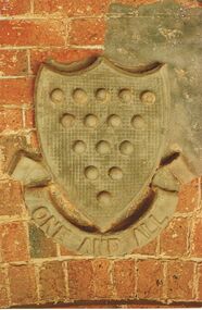
Document - CORNISH COLLECTION: DOCUMENTS RELATING TO CORNISH CREST
Documents, relating to Cornish Crest: a. colour photograph of a crest mounted on a brick wall (located at old Fuse Factory? - Handwritten inscription on back states ''One of C Coat of Arms on its Décor''; b. Note titled ''What is the Meaning of the Cornish Crest'' with diagram - historical detail; c. Copy of diagram of Coat of Arms with some historical information; d. short article extract re ''Duke of Cornwall'' and ''Duchy''.bendigo, buildings, bendigo fuse factory, cornish coat of arms. "one and all" -
 Hume City Civic Collection
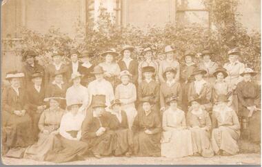
Photograph, 1916
Photo taken of the Sunbury Branch of the Red Cross in 1916. The group was at Rupertswood. Miss Agnes Eadie is sitting in the centre of the middle row and is wearing a black hat. The postcard was sent to someone by Ruby.A sepia photograph presented in postcard format of members of the Sunbury Red Cross 1916. There are 3 rows of ladies in the group - 8 seated on low forms in the front, 11 on chairs in the middle row and 11 standing at the back. There is a brick wall with three windows and creepers in the background in the grounds of Rupertswood. Miss Agnes Eadie is identified as sitting in the centre of the middle row and wearing a black hat. The postcard was sent to someone called Ruby.on back: POST CARDsunbury red cross branch, rupertswood, red cross, postcards, sunbury, eadie, agnes (miss), -, ruby, 1910s, george evans collection -
 Stawell Historical Society Inc
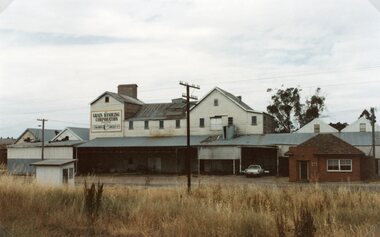
Photograph, Wimmera Flour Mill during Demolition -- Coloured
Various colour photos of Wimmera Flour Mill at time it was being demolished. Note roof being dismantled. Rail line in foreground. Willaim Frayne founded the Wimmera Flour Mill on a site in Taylor Street (beside the railway line) Stawell 1876. When Willian Frayne dies 1899 his son George took over the mill. The mill continued to be a propriety company until early 1966, when it was sold to the Victorian Mill Owners. The sale was forced because of the lack of export markets. A factor which affected most country mills. The Victorian Oat Growers Pool took over on July 1st, 1967. Trading under the name of Wimmera Flower Mill as a subsidiary company. Later years it sold clipped and graded seed, oats, stockfeed for poultry, pigs and dairy cattle and all types of crushed grain. The original Frayne homestead still stands behind where the Mill stood facing Frayne Street. In 2007 during our "Collection Review" the four smaller colour photos, which were donated by Mr. Mick Walsh, 52 Patrick St Stawell were very similar to the bigger photo in the file 139.6e.139-6 a-d & e Coloured photographs showing various views of the Wimmera Flour Mill or Grain Handling Corporation building in progress of being demolished. There is a red brick building with a tiled roof in these coloured photos. The rail line is shown in foreground of 139-6 e. Our records on the data base show 139-6e to be a black & white photo but the same photo in the office folder is an enlarged colour photograph. Grain Handing Corporation stawell industry -
 Ballarat Tramway Museum
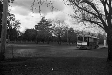
Photograph - Black & White Photograph/s, David Endacott, 14/08/1971 12:00:00 AM
Black and white photograph and negative of tram 33 outbound to Gardens via Sturt St. West, in Sturt St. west, with long brick fence in the background. Photo taken Saturday, August 14, 1971. Original print by David Endacott, duplicate print (1263A) by John Phillips 12/1999 - three copies held 5/2001. Original neg scanned at hi res and updated 11/5/2020. On original print "Sturt St. West / Sat 14 Aug 1971" in pencil.trams, tramways, ballarat, sturt st. west, tram 33 -
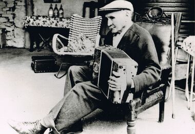 Bendigo Historical Society Inc.
Photograph - PETER ELLIS COLLECTION: MAN PLAYING ACCORDION
(1) An older man seated in an armchair with an upholstered back with a carved top playing an accordion? He is wearing shirt, cardigan, trousers, lace up boots and a cap. His walking stick is hanging on the back of the chair. (2) A middle aged man sitting in front of a brick fireplace playing an accordion. The instrument has a plate near the keys with 'The Grand Organ' printed on it. It has decorative scroll work on the corner near the keys.photo, individual, male, peter ellis collection, accordion/concertina players -
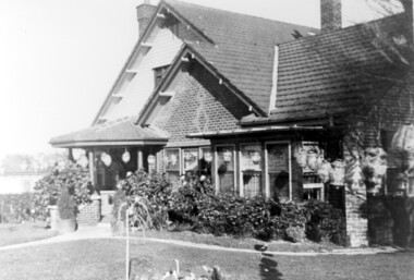 Surrey Hills Historical Society Collection
Photograph, Home and surgery of Dr William Langley Carrington, 174 Union Road, 1935
The building was erected in c 1913 as a home / surgery for Dr James L Blakie (1868-1937), who originally lived / practised across the road. It was designed by architect Arthur William Plaisted (1890-1965) and is an early example of attic-style Californian bungalow style. Dr Carrington ( 1900-1970) succeeded Dr Blakie and practised at 174 Union Road from 1930-1970. Now known as the Surrey Hills Medical Centre.Black and white photo of the surgery and home of Dr and Mrs William Langley Carrington at 174 Union Road on the corner of Guildford Road, Surrey Hills.. The exterior of the building is decorated with paper lanterns around the windows and veranda for the Empire Day celebrations in 1935. The building is 2 storey, of brick construction with a tiled roof and front porch. It has a bay window front right. Shadows indicate the photo was taken early morning in winter.medical services, guildford road, union road, dr william langley carrington, mr arthur plaisted, dr james landells blakie, californian bungalow, dr bill carrington -
 Bendigo Historical Society Inc.
Document - Phillip's Water Wheel, Diamond Hill, Bendigo, 1876
'Messrs. George Phillips and Richard Williams erected a water wheel crushing machine near the site of the Old Albert shaft at Diamond Hill'. ( Bendigo Advertiser 4th June, 1890). The lack of water available for the venture from the water race caused much controversy in the following years. There was only enough water available in July 1890, to allow the company to operate three head of a ten head stamper. The site of the water wheel is still visible on the side of the water race at Diamond Hill. Mr. Geo Phillips held 1000 shares in the float of the Kangaroo Hydraulic Crushing & Gold Mining Company. He was one of the largest shareholders. (Victorian Government Gazette 72 Page 2260, 1893) Black and white photocopy. Image shows the Phillip's Water Wheel on Diamond Hill, Bendigo, date unknown but must be in 1890's. Three men and a dog standing in front of a weatherboard shed, brick chimney on side. Large water wheel on left hand side of image. Three images, 2008, showing former site of water wheel on channel, after heavy rain in district caused dry channel to run. mining, sandhurst, phillip's hydraulic waterwheel, stafford gold mine, diamond hill, george phillips, richard williams -
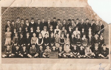 Surrey Hills Historical Society Collection
Work on paper - Photograph, Surrey Hills State School 2778, Grade 6, 1935, 1935
Information from the donor by email gives: Norma Pryde is identified as the girl in the second row on the far right. Her parents Norman & Hilda Pryde lived at 50 Broughton Road, Surrey Hills. The home was named 'Strathaven' after the town in Scotland where Norman's father came from. Norman & Hilda were married in 1923. Norma was born in 1924. Norman worked for Moran & Cato so the family moved around a lot for his work and is thought to have rented out the house from time to time. During some time in the 1920s they were listed on electoral rolls in Nyah West and then in 1942 they were listed in Hamilton. When the war ended they came back to Melbourne and in the late 1940s built a home at Blackburn. Norma married John Cleak in 1947 in Camberwell. This photo is representative of the large classes that were common in the interwar period.An original B&W postcard photo of a class taken outside against a brick wall. There are 34 boys in 2 rows. The back row of 20 boys would have been standing on a bench and in the front row the 14 boys are seated on the ground. The girls are standing in 2 rows - 14 girls in the second back row and 16 girls in the second front row. A total of 64 students. There does not appear to be a standard uniform.Front: In blue ballpoint: An arrow + ME Rear: In grey lead pencil on the LHS: "Miss N Pryde / Kitchener Rd / Croydon / Vic"; a stamp in purple ink on the RHS: "SUZANNE ET CIE PTY. LTD. / 357 COLLINS STREET / MELBOURNE." In addition a diagonal blue squiggle.surrey hills, norma pryde, norma cleak, jenny pomeray, surrey hills state school 2778, education, 1930-1939, 1935 -
 Charlton Golden Grains Museum Inc
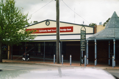
Photograph, Bendigo Bank, High St Charlton c. 2002
Bendigo Bank built on land formerly occupied by Clark's Butcher Shop. Branch opened in 2003.Colour photograph of Bendigo Bank building. Single storey brick building. Signage is partially obscured by tree and reads 2003 Charlton & District Community Bank Branch Bendigo Bank. Blue timber covered entrance to the Traveller's Rest complex on the RH side. Person going past on mobility scooter. Green signage for Traveller's Rest reads CAFES BAKERY PUBLIC TOILET CHEMIST HOTELS MOTELS SUPERMARKETS NEWSAGENCY.charlton, bendigo bank, business, industry, clark's butcher -
 Bacchus Marsh & District Historical Society
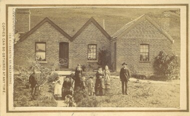
Photograph, Burnip Family and House Coimadai 1883
The family group in this image is the Burnip family. George Burnip came to Australia in 1854. In 1856 he married Julia Grant. Sometime after this he came to the Bacchus Marsh area and purchased a farm near Coimadai and named it 'The Pines'. George Burnip was active in public affairs as a member of School Board of Advice and the Agricultural Society. One of the two men in this image is likely to be George Burnip, probably the man on the left. The man standing on the right is possibly his son, John, who would have been 22 at the time this photo was taken. The woman seated on a chair placed on the pathway is probably Mrs Julia Burnip. The woman standing with her arms crossed is possibly Mrs Julia Carroll (nee Burnip). The children pictured are likely to be the five Burnip children and two others.Small sepia unframed photograph on card with gold border framing photograph. Housed in the album, 'Photographs of Bacchus Marsh and District in 1883 by Stevenson and McNicoll'. An image showing a brick house with a pitched roof in three separate sections. Two chimneys on either side of the house can be seen. Standing in front of the house is a group of people, male and female, young and old. One female is older and is seated in a chair. At the front of the group is a dog.On the front: Stevenson & McNicoll. Photo. 108 Elizabeth St. Melbourne. COPIES CAN BE OBTAINED AT ANY TIME. On the back: LIGHT & TRUTH inscribed on a banner surmounted by a representation of the rising sun. Copies of this Portrait can be had at any time by sending the Name and Post Office Money Order or Stamps for the amount of order to STEVENSON & McNICOLL LATE BENSON & STEVENSON, Photographers. 108 Elizabeth Street, MELBOURNE houses coimadai vic, stevenson and mcnicoll 1883 photographs of bacchus marsh and district, houses bacchus marsh, burnip family bacchus marsh -
![Painting: Park Street [Adeney Avenue] Kew](/media/collectors/550653872162f11fb04854aa/items/5826877cd0cdd11284ad5413/item-media/614ac683a53a0756fd5e49da/item-fit-380x285.jpg) Kew Historical Society Inc
Kew Historical Society IncPainting, Park Street [Adeney Avenue] Kew, c. 1896
‘Adeney Avenue’ was the title given to this painting following its donation to the Kew Historical Society, yet the work’s origins predate the naming of Adeney Avenue in 1907 [originally gazetted as ‘Park Street’ (1865) and ‘Park Street South’ (1875).] Park Street ran between High Street and Parkhill Road beside what was later to become ‘Victoria Park’. This area was described in 1851 as “…a dense forest of gums and wattles which were to be largely cleared by 1888 after the naming of a recreation reserve”. The Reserve was still bisected by an unnamed creek in 1896, when the area was surveyed by the MMBW. The panoramic vista selected by the artist would appear to include ‘Eborensis’ (c.1895) on the corner of Parkhill Road and what was then Park Street, with views across cleared land towards the distant ranges. In the 19th century, north Kew was largely undeveloped farms stretching down to the Yarra. Oil on canvas by an unidentified artist of a panoramic view depicting what is now known as East Kew with mountains on the horizon. In the foreground is a two storey brick residence - Eborensis - located on the northeast corner of Parkhill Road and what is now Adeney Avenue. The view of the landscape and its rolling hills resulted from farming practices adopted following colonisation and settlement. Trees in the foreground and in the distance include remnant Eucalypts and introduced exotics.Label on rear of frame states "House on corner of Adeney Ave & Parkhill. [Regd. 254"]. Otherwise unsigned and undatedadeney avenue (kew), eborensis, park street (kew) -
 Whitehorse Historical Society Inc.
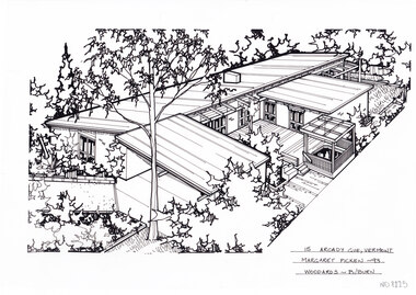
Artwork, other - Ink Line Drawing, Margaret Picken, 15 Arcady Gve., Vermont, 1993
A property illustration by Margaret Picken Commissioned by a real estate agency for the purpose of advertising 15 Arcady Gve., Vermont This property is listed as having sold for $178,000 in 1995 Made by using Rotring ‘Rapidigraph’ drafting pens with Rotring ink on Rapidigraph polyester drafting film, double matte. Trained as a cartographic draftsman within the mining industry, Margaret Picken is an artist who worked producing property illustrations for real estate agencies in eastern suburbs of Victoria from 1983-2005. Retiring from the industry as technological changes favored coloured photography over illustrations, and commissioning companies over sole contractors.This artwork is of Historical Significance as a record of local domestic architecture.A black ink line drawing on drafters film by Margaret Picken, of a black and white line drawing of a single story brick house from a angled birdseye view, on a left to right diagonal. On the left, a horizontal driveway leads to a connected carport, with the main of the house of the left. Wrapping around a central decked courtyard. There is a backyard in the background in the upper right corner. There are two hole punch holes just below centre of the upper edge15 Arcady Gve., Vermont Margaret Picken -93 Woodards - B/Burnwhitehorse historical society, schwerkolt cottage, housing, architecture, margaret picken, house, garden, real estate, vermont -
 Port of Echuca
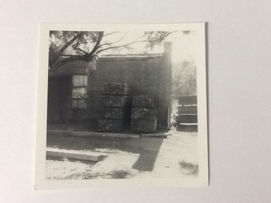
Black and white photograph, Approx. 1975
The old brick Murray River Sawmill office was demolished around 1975. This appears to be part of one of the office buildings associated with the sawmill, taken in shadow, with the building well back on the block, on the bridge side. There is a dirt driveway in front of the building and stacks of timber next to the chimney side of the building. Trees are visible behind these stacks of timber. Two stacks of timber (1x 4 blocks high, 1 X 3 blocks high) are in front of the building between the window and the chimney This relates to photographs P000106, P000105 Sawmills in the Echuca area were historically and socially significant being a large employer in the area. The Murray River sawmill was one of the biggest and longest operating sawmills in the area. Black and white photograph of an old Murray River Sawmill building with the chimney to the right and a door and window on the left. Two stacks of timber planks are against the wall between the window and the chimney. A dirt driveway is in front of the building with timber planks edging the driveway.On the reverse in pencil "Old M. R. S. Building well back on the block on the bridge side. Near old offices, also demolished about 1975??" Kodak, , in blue ink "0932"murray river sawmills, echuca, echuca, victoria, pullicino, j (unconfirmed) -
 Marysville & District Historical Society
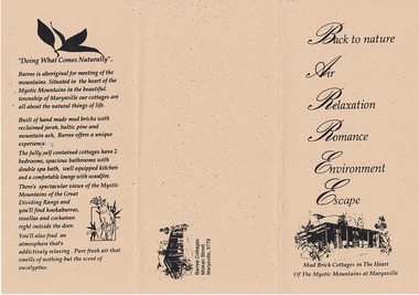
Ephemera (Item) - Information brochure, BARREE, Unknown
An information brochure regarding Barree Cottages in Marysville. The cottages were built of 110 year old recycled Jarrah from the Fremantle Wool Stores. They had 90 year old Mountain Ash (native to the area) posts and beams from the South Melbourne Wool Stores. Old red bricks were used to create feature walls within the cottages which were two bedroom and fully self contained. These cottages, along with the majority of the buildings in Marysville, were destroyed in the 2009 Black Saturday bushfires.An information brochure regarding Barree Cottages in Marysville.marysville, victoria, australia, information brochure, barree mud brick holiday cottages, accommodation, 2009 black saturday bushfires -
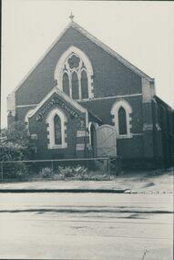
 Eltham District Historical Society Inc
Photograph, George W. Bell, St Mary's Catholic Church, cnr Main Road and Henry Street, Eltham, c.1960
St Mary's Catholic Church, cnr Main Road and Henry Street, Eltham was opened/blessed October 13, 1912. The wooden church was built to replace an earlier brick church also known as St Mary's (1865-1912), which had been situated on the main road near present day Wingrove Park. The church and land cost £1,400 (Evelyn Observer). The wooden church was destroyed by fire in 1961. A new modern architecture (1960s) style church was erected - Our Lady of Help Christians Church. This photo forms part of a collection of photographs gathered by the Shire of Eltham for their centenary project book,"Pioneers and Painters: 100 years of the Shire of Eltham" by Alan Marshall (1971). The collection of over 500 images is held in partnership between Eltham District Historical Society and Yarra Plenty Regional Library (Eltham Library) and is now formally known as the 'The Shire of Eltham Pioneers Photograph Collection.' It is significant in being the first community sourced collection representing the places and people of the Shire's first one hundred years.Digital image 4 x 5 inch B&W Neg Print B&Wsepp, shire of eltham pioneers photograph collection, eltham, roman catholic church, church, catholic church, henry street, main road, st marys catholic church -
 Flagstaff Hill Maritime Museum and Village
Domestic object - Terracotta Cooler Top, Ovens Pottery, c. 1890-1892
The Ovens pottery operated from 1881 to1892 they had taken over H L & E pottery at Beechworth in 1888 but mounting debts forced the Ovens company to close in 1892. During their short ten years of operation they produced stoneware garden urns, vases, cheese dishes, ginger beer bottles, butter coolers, water filters, wine and spirit barrels, bread plates, jugs, teapots, storage jars, pots, tiles, flower pots, spittoons, basins, bowls, demijohns, lidded crocks, pipes and bricks.A significant item made by an early Australian pottery in Beechworth Victoria, this company made many utilitarian items for the Victorian domestic market. It gives us today a snapshot into early Australian companies that were unable to sustain manufacturing their products into the 20th century, due in part to the rising imports of cheaper items from overseas.Red terracotta butter cooler comprising, round base with ridged lip, and bell shaped, domed lid with spherical handle on topMarked "Ovens Pottery, Co Ltd, Patd 1890, Beechworth" flagstaff hill, warrnambool, shipwrecked coast, flagstaff hill maritime museum, flagstaff hill maritime village, great ocean road, cooler, terracotta cooler, utensil, kitchen ware, terracotta, food container, food preservation, butter cooler, ovens pottery -
 Eltham District Historical Society Inc
Folder, 2 Metery Road, Eltham South
Morrison Kleeman Real Estate sales information material for the Alistair Knox designed house known as the Zull House. "Nestled into a private hill of more than an acre of established gardens, shady ornamental gardens, shady ornamental grapesvines and gumtrees, sounds of bellbirds engulf this Alistair Knox home of special ambience. This home features the textures and colours of nature, home made Hawthorn bricks, flooirng slate from the old St Kilda baths and recycled timbers..." The property was sold Feb 26, 2004 (Source: realestateview.com.au) Knox was a pioneer in the use of mudbricks and recycled materials and is significant to his contribution of this style of architecture in Eltham and the wider Shire of Nillumbik.1 documents, 2 pages A4 gayle blackwood collection, houses, morrison kleeman real estate, metery road, eltham south, alistair knox, zull, st kilda baths -
 Bendigo Historical Society Inc.
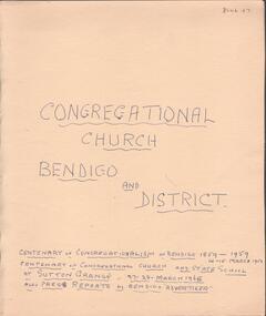
Document - Lydia Chancellor collection: congregational church Bendigo and district
The Sutton grange Congregational Church was built in 1865. Original services were held in the home of Mr James Grey who served the church for 50 years. The Bendigo Congregational church originally operated out of the Mechanics Institue building before moving temporarily to the Church of England school room. In May 1858, a meeting was held to establish a permanent building and tenders were called in September 1858. Land was purchased in Forest Street from the estate of Mr WIlkinson and the new brick structure was opened 28/11/1858.Manilla folder titled: Congregational Church Bendigo and district. Centenary of congregationalism in Bendigo 1859 to 1959, 14-15 March 1959. Centenary of congregational church and state school at Sutton Grange, 27-28 March 1965. Also, press reports in the Bendigo Advertiser.sutton grange, congregational church, centenary -
 Uniting Church Archives - Synod of Victoria
Photograph, undated
The memorial stone of the UMFC in Church St. Richmond was laid in December 1868. The bluestone church, which seated 308 people, was designed by G.R. Cox and built by John Wright. It was opened in May 1869. By 1890 subsidence in the foundations of the building had caused the bluestone façade to bulge dangerously outwards and a new façade of red and white brick was constructed. The memorial stone of the new façade was laid on 7th June 1890. Before construction of the 1868 church, services were held in a weatherboard building which subsequently served as the Sunday School.B & W photograph of the exterior of the Richmond United Free Methodist Church.united free methodist church, church street richmond, bluestone, g.r. cox, john wright. -
 Ballarat Heritage Services
Digital Photograph, Drogheda Museum, Ireland, 2016, 09/2017
The museum houses an extensive collection. It provides educational programmes for schools and other groups. There is a unique collection of 19th century guild banners representing Weavers, the Shoemakers, and the Carpenters. Trade banners also represent the Brick and Stonemasons, Farm Labourers and the Boyne Fishermen. The Old Drogheda Society founded in 1964 by a group of concerned citizens for the preservation of Drogheda's historical monuments and the collection and recording of historical material relating to the town and surrounding area established the award winning museum. The Museum was opened in 1974 and in 2013 achieved full accreditation by the Heritage Council. -
 The Beechworth Burke Museum Research Collection
Card (Series) - Index Card, George Tibbits, 14 William Street Beechworth (cnr Last St), 1976
George Tibbits, University of Melbourne. Faculty of Architecture, Building and Town & Regional PlanningIndex system that support the research for Beechworth : historical reconstruction / [by] George Tibbits ... [et al]Arranged by street names of BeechworthEach index card includes: street name and number of property, image of property, allotment and section number, property owners and dates of ownership, description of the property according to rate records, property floor plan with dimensions.beechworth, george tibbitsbeechworth, george tibbits -
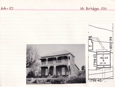 The Beechworth Burke Museum Research Collection
Card (Series) - Index Card, George Tibbits, 14 Bridge Street, Beechworth, 1976
George Tibbits, University of Melbourne. Faculty of Architecture, Building and Town & Regional PlanningIndex system that support the research for Beechworth : historical reconstruction / [by] George Tibbits ... [et al]Arranged by street names of BeechworthEach index card includes: street name and number of property, image of property, allotment and section number, property owners and dates of ownership, description of the property according to rate records, property floor plan with dimensions.beechworth, george tibbitsbeechworth, george tibbits -
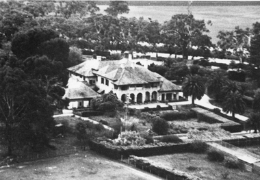 Stawell Historical Society Inc
Photograph, “Warranooke” Homestead in Glenorchy 1867 -- aerial view
Aerial View of “Warranooke” Homestead. “Warranooke” Homestead built 1867 enlarged 1926. Shows extensive gardens at front. A very early property in our district Warranooke The main names associated with the property Ayrey - Darnell - Nicoll, later Campbell. Mrs. Campbell built Charles Ayrey's daughter. The Campbells built up the station buildings. The homestead was virtually rebuilt in brick, making it one of the largest and most elaborate in the East Wimmera. Warranooke homestead built 1867, enlarged 1926 destroyed by fire 13th Feb. 1979.Black and white aerial photograph of building showing landscape around the homestead. The photo is on a card with some gold decorations.glenorchy -
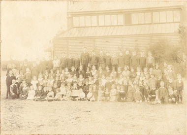 Chelsea & District Historical Society Inc
Photograph - Chelsea State School, Children outside Hoadleys Hall "Joss House", 1914
In January 1912, a small school was established at Chelsea, with 65 students, in Hoadley’s Hall, located on Main Road, Chelsea, near the Nepean Highway. Due to its Oriental appearance, the local people called this hall “The Joss House.” Hoadley's Hall was was originally used at the Melbourne Show Grounds by Hoadley's which was moved to Chelsea. The Hall was also used for church services by different religions before they built their own churches. A new brick school was built on Argyle Avenue and officially opened on 27 January 1915.Sepia photo of children and adults at Chelsea State School, in 1914, standing in front of Hoadley's Hall.chelsea, education, chelsea primary school, school, hoadleys hall, joss house, chelsea state school -
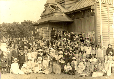 Chelsea & District Historical Society Inc
Photograph - Chelsea State School, Children outside Hoadleys Hall "Joss House", 1912
In January 1912, a small school was established at Chelsea, with 65 students, in Hoadley’s Hall, located on Main Road, Chelsea, near the Nepean Highway. Due to its Oriental appearance, the local people called this hall “The Joss House.” Hoadley's Hall was was originally used at the Melbourne Show Grounds by Hoadley's which was moved to Chelsea. The Hall was also used for church services by different religions before they built their own churches. A new brick school was built on Argyle Avenue and officially opened on 27 January 1915.Sepia photo of children and adults at Chelsea State School, in 1912, standing in front of Hoadley's Hall.chelsea, education, chelsea primary school, school, hoadleys hall, joss house, chelsea state school -
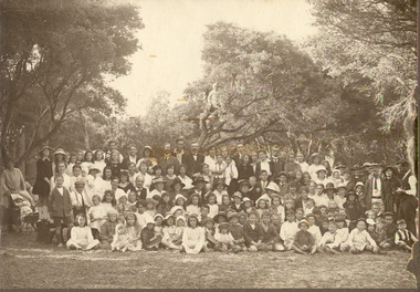 Chelsea & District Historical Society Inc
Photograph - Chelsea State School, Students, staff and Family on a picnic, c 1912-14
In January 1912, a small school was established at Chelsea, with 65 students, in Hoadley’s Hall, located on Main Road, Chelsea, near the Nepean Highway. Due to its Oriental appearance, the local people called this hall “The Joss House.” Hoadley's Hall was was originally used at the Melbourne Show Grounds by Hoadley's which was moved to Chelsea. The Hall was also used for church services by different religions before they built their own churches. A new brick school was built on Argyle Avenue and officially opened on 27 January 1915.Sepia photo of children, staff and family from Chelsea State School, at a picnic, amongst the te trees.chelsea, education, chelsea primary school, school, hoadleys hall, joss house, picnic, te trees -
 Chelsea & District Historical Society Inc
Photograph - Chelsea State School, Children outside Hoadleys Hall "Joss House", 1912
In January 1912, a small school was established at Chelsea, with 65 students, in Hoadley’s Hall, located on Main Road, Chelsea, near the Nepean Highway. Due to its Oriental appearance, the local people called this hall “The Joss House.” Hoadley's Hall was was originally used at the Melbourne Show Grounds by Hoadley's which was moved to Chelsea. The Hall was also used for church services by different religions before they built their own churches. A new brick school was built on Argyle Avenue and officially opened on 27 January 1915.Black and white photo of children at Chelsea State School, in 1912, standing in front of Hoadley's Hall.chelsea, education, chelsea primary school, school, hoadleys hall, joss house -
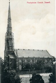 Stawell Historical Society Inc
Photograph, St. Matthew’s Presbyterian Church
St. Matthew’s Presbyterian Church Stawell. Now United Church. This landmark of Stawell was opened on 11th April 1869. The tower and spire, overall height of 148 feet, cost 1352 pounds and was paid for by an early mine owner. In March 1869, a month before the Church was opened, the local paper reported that a large red flag on the top of the Presbyterian Spire meant that the last brick had been laid and the massive gilt ball and cross had been placed in position. The Church has some fine stained-glass windows. Two identical side views of a church with a tall steeple. These photos were taken from the original Post Cards in Album 13, p.41. The photo shows a Tennis Courts in foreground with a picket fence around the church. Presbyterian Church, Stawell written on the front of the post card and June' 09 Stawell written in pencil on the back. Post cards printed in Germany.stawell religion -
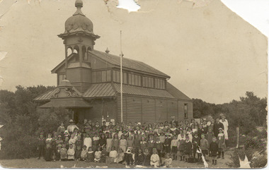
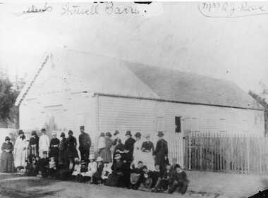 Stawell Historical Society Inc
Photograph, Salvation Army Barracks in Main Street
Salvation Army Barracks Main Street Stawell. Weatherboard building part roof corrugated iron - remainder wooden shingles. Picket fence in foreground. Large group of people standing and seated on the footpath. The original Salvation Army Barracks is now at the rear of the present Citadel a red brick building. Stawell Corps was opened in the year 1884 in the month of May. The first meeting was conducted in a Church but afterwards the old market (area present Library) was secured for meetings. Captain Furbur and Lieutenant Quick were the first officers appointed. Photograph of a weatherboard building with a group of people standing and sitting in front of a picket fence. Part of the roof of the building is corrugated iron - remainder wooden shingles. The group of people standing and seated on the footpath, are a mixture of adults and children, some in uniforms, women in long dresses. Salvation army Barracks above the building door. Written in handwriting Stawell Barracks Mrs. R.J. Reeve.stawell religion -
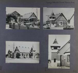 Glen Eira Historical Society
Album - Album page, Carnegie Methodist Church, Neerim Road, Circa 1972
This photograph is part of the Caulfield Historical Album 1972. This album was created in approximately 1972 as part of a project by the Caulfield Historical Society to assist in identifying buildings worthy of preservation. The album is related to a Survey the Caulfield Historical Society developed in collaboration with the National Trust of Australia (Victoria) and Caulfield City Council to identify historic buildings within the City of Caulfield that warranted the protection of a National Trust Classification. Principal photographer thought to be Trevor Hart, member of Caulfield Historical Society. Most photographs were taken between 1966-1972 with a small number of photographs being older and from unknown sources. All photographs are black and white except where stated, with 386 photographs over 198 pages. From Victorian Heritage Database citation for HO47 Uniting Church, 254 Neerim Road https://vhd.heritagecouncil.vic.gov.au/places/42432 (as at 28/10/2020) The former Methodist church (now Uniting church) complex at 252-54 Neerim Road, Carnegie, consists of the original timber church of 1886, the present brick Arts and Crafts influenced church of 1914, designed by A. Phipps Coles, the timber hall attached to the original church, built during the interwar period and the present brick hall of 1933, designed by J.F. Snell. From Victorian Heritage Database citation for HO47 Uniting Church, 254 Neerim Road https://vhd.heritagecouncil.vic.gov.au/places/42432 (as at 28/10/2020) The complex has aesthetic, historical and social significance. Its aesthetic value is derived from the extreme simplicity of the original church and the highly picturesque, eclectic, Arts and Crafts influenced character of the main church and hall. Its historical value rests in the early date of the original building and the manner in which the remaining buildings are representative of the principal period of settlement of the locality. The social significance derives from the use of the site as a place of worship since the commencement of the closer settlement of Carnegie from as early as 1886. Page 146 of Photograph Album with four photographs (3 landscape, 1 portrait) of Carnegie Methodist Church, Neerim Road.Handwritten: Carnegie Methodist Church Neerim Road [top right] / 146 [bottom right]trevor hart, neerim road, carnegie methodist church, church, toolambool road, wesleyan methodist church, breslin gallery, anthony breslin, 1910's, american romanesque, spire, half gabled tower, art, gallery, cafe, arched doorways, red brick, uniting church, carnegie, arts and craft style, a p coles, a coles, j f snell, j snell, halls