Showing 3212 items
matching road maps
-
 Vision Australia
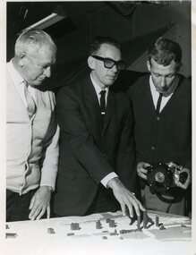
Photograph - Image, Using a 3D map of Sydney
A blind man feels model buildings on a relief map of the Sydney CBD whilst two others look on. B/W photograph of blind man using relief mapLearning layout of City of Sydney by raised map Orientation - historical RBS XIroyal blind society of nsw, maps -
 Vision Australia
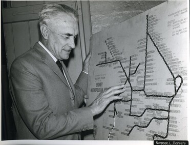
Photograph - Image, Ron Bruce reading Sydney Train map, 1971?
Ron Bruce reading a Braille map of Sydney's railway network.B/W photograph of man reading braille map1/71016 M&O -historicalroyal blind society of nsw, ron bruce, maps -
 University of Melbourne, Burnley Campus Archives
Plan, [Historical Maps of Richmond Park], 1862-2000
(1) Proposed reserve for Horticultural & Experimental Garden in the Survey paddock Richmond. R.19A (1865). Shows Swan Street Extension. Gazettals 1877, 1887. (2) As (1). Half of map only Annotation by A. Purchas, 9 October, 1862. (3) Plan of Richmond park. A.L. Martin Authorised Surveyor, 31st August, 1872. [Dept. of lands & Survey Melbourne, J. Noone, 6th September 1872.] Map in 4 sheets. (4) Richmond Park. Surveyed by Geo. Black, Authorised Surveyor 13.8.91 (2 copies). (5) [Richmond Park] Shows road alignments gazetted 1871 & 1881 (part copy only - Neg. 18375). (6) City of Richmond Parish of Jika Jika County of Bourke. Department of lands & Survey, 1919 (annotations i.e. Melb. City Link, Amrad, etc. to 1994.) (7) Burnley gardens, 2000. Produced by P. Tulk, Institute of Land & Food Resources, Burnley College, 2000 (re area proposed for heritage listing.)richmond park, survey paddock -
Surrey Hills Historical Society CollectionThe Armitstead family operated a woodyard and ice delivery business in Union Road, Surrey Hills. There are a number of photos in this collection documenting this business. The family lived nearby in Croydon Road. The site of the woodyard is now the Surrey Hills Neighbourhood Centre.
-
Vision Australia
Administrative record (Series), Royal Blind Society of New South Wales Annual Reports, 1952-2004
Royal Society for the Blind of New South Wales, 7 Mitchell Street, Enfield, NSW 2136To provide information on general information on work undertaken, financial position, income and cash flow.Single volumes created annually from 1952 until 2004.President's Report, Finance Report, General Overview of Services.corporation records, royal blind society of new south walescorporation records, royal blind society of new south wales -
Vision Australia
Administrative record (Series), Braille and Talking Book Library, 1972-1991
Braille and Talking Book Library, 31-51 Commercial Road, South Yarra, Victoria 3141To provide information on general information on work undertaken, financial position, income and cash flow.Single volumes created annually from 1972 until 1991.Minutes of AGM, Annual Report of Directors, President's Report, financial informationcorporation records, braille and talking book librarycorporation records, braille and talking book library -
 Vision Australia
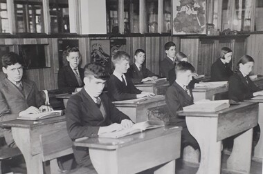
Photograph - Image, School children in class room
10 students read at their desks in the classroom. Braille maps are on the walls and their are miniature wooden tanks, airplanes and a building on top of the cupboard. The walls are wood panelled to halfway up, then glassed.1 black and white photograph of 10 pupils in the school roomrvib burwood school, education -
Vision Australia
Administrative record (Series), Lady Nell Seeing Eye Dog School, 1961-2008
Braille and Talking Book Library, 31-51 Commercial Road, South Yarra, Victoria 3141To provide information on general information on work undertaken, financial position, income and cash flow.Single volumes created annually from 1972 until 1991.Minutes of AGM, Annual Report of Directors, President's Report, financial informationcorporation records, lady nell seeing eye dog schoolcorporation records, lady nell seeing eye dog school -
Vision Australia
Administrative record (Series), Braille Library of Victoria, 1972-1991
Braille Library of Victoria, 31-51 Commercial Road, South Yarra, Victoria 3141To provide information on general information on work undertaken, financial position, income and cash flow.Single volumes created annually from 1962 until 1971.Minutes of AGM, Annual Report of Directors, President's Report, financial informationcorporation records, braille library of victoriacorporation records, braille library of victoria -
Vision Australia
Administrative record (Series), Victorian Association of Braille Writers, 1895-1961
Victorian Association of Braille Writers, 31-51 Commercial Road, South Yarra, Victoria 3141To provide information on general information on work undertaken, financial position, income and cash flow.Single volumes created annually from 1895 until 1961.Minutes of AGM, Annual Report of Directors, President's Report, financial informationcorporation records, victorian association of braille writerscorporation records, victorian association of braille writers -
 Vision Australia
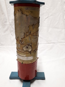
Map - Object, R.F. Tunley, Braille cylinder map, 1940-1950s
... Vision Australia 454 Glenferrie Road Kooyong melbourne ...This map was produced by Richard Francis Tunley and given to the Victorian Braille Library for use by it's patrons. Mr Tunley was a prolific Braille map maker as well as producing other items for blind and vision impaired children, advocated for compulsory education for blind and deaf children and established the Queensland Braille Map and Model Club. Leading by example, his maps were treasured by those who used them and were an outstanding piece of craftsmanship. In this example, the metal cylinder sits on a wooden base and can be turned via a handle in the wooden top or rotating the sides. A brailled red metal plate occupies the bottom third, and large continents have a metal plate, cut to shape, upon which braille country/continent names are placed. Major rivers are traced through raised lines in the metal continental plates, twisted wire traces shipping routes with associated brailled metal plates, raised metal pins in some major locations and more explanatory plates sit in various oceans.1 metal cylindrical map with tactile markersCommercial & Strategic Map of the British Empire Presented to the Victorian Braille Librarybraille library of victoria, r.f. tunley -
 Vision Australia
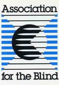
Administrative record (Series), Association for the Blind Annual Reports, 1955
Association for the Blind, 7 Mair Street, Brighton Beach, Victoria, Australia.To provide information on general information on work undertaken, financial position, income and cash flow.Single volumes created annually from 1955 until 1998.President's Report, Finance Report, General Overview of Services.association for the blind, corporation recordsassociation for the blind, corporation records -
Vision Australia
Administrative record (Series), Royal Victorian Insitute for the Blind Annual Reports, 1892
Royal Victorian Institute for the Blind, 557-563 St Kilda Road, Melbourne, 3000.To provide information on general information on work undertaken, financial position, income and cash flow.Single volumes created annually from 1892 until 2004.President's Report, Finance Report, General Overview of Services.corporation records, royal victorian institute for the blindcorporation records, royal victorian institute for the blind -
Vision Australia
Administrative record (Series), National Information Library Service annual reports, 2002-2004
NILS, 454 Glenferrie Road, Kooyong, Victoria, 3144To provide information on general information on work undertaken, financial position, income and cash flow.Single volumes created annually from 2002 until 2004.Chairman's message, CEO message, Finance Report, General Overview of Services.corporation records, national information library servicecorporation records, national information library service -
 Vision Australia
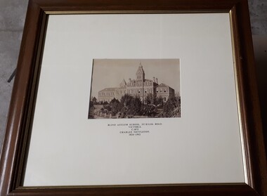
Photograph - Image, Charles Nettleton, Blind Asylum School, St Kilda Road, circa 1875
Unsubstantiated photograph of the Asylum for the Blind in 1875. The four storey bluestone building rises above a group of trees planted in the garden. A picket and wire/string fence border the unpaved circular driveway. 2 black and white images of the Guiding Light at Elanora Blind Asylum School, St Kilda Road Victoria c. 1875 Charles Nettleton 1826-1902 Spencer Scott Sandilands 546 High Street, East Preson, 3181 Melbourne, Victoria, Australia, Tel: (03) 529 8011 Fax: (03) 521 1754 33 George Street, The Rocks, 2000 Sydney, New South Wales, Australia, Tel: (02) 241 4251 Fax: (02) 2414535 Rare Prints, Antiquarian Books, Old Maps, Australiana, Antiques, Photographs, Framing c.1875 Charles Nettleton School from the Blind Original Photograph $65 Guaranteed over 100 years oldroyal victorian institute for the blind, buildings -
Vision Australia
Administrative record (Series), Vision Australia Annual Reports, 2004
Vision Australia, 454 Glenferrie Road, Kooyong, Victoria 3144To provide information on general information on work undertaken, financial position, income and cash flow.Volumes created annually from 2004. Some years a second volume was created for the financial report.Chairman's message, CEO message, Finance Report, General Overview of Services.corporation records, vision australiacorporation records, vision australia -
Vision Australia
Administrative record (Series), Royal Blind Foundation Queensland Annual Reports, 2002
Royal Blind Foundation Queensland, Kent Street, Woolloongabba, Queensland 4103To provide information on general information on work undertaken, financial position, income and cash flow.Single volumes created annually from 2002 until 2006.President's Report, Finance Report, General Overview of Services.corporation records, royal blind foundation queensland, queensland blind industrial centrecorporation records, royal blind foundation queensland, queensland blind industrial centre -
 Port Fairy Historical Society Museum and Archives
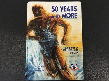
Book, Alan Best and Contributors, 50 Years and More / A History of Surf Life Saving Victoria
History of Surf Life Saving Victoria over 50 years154p. :I;;. (Some col.), maps. Ports., fascism,:non-fictionHistory of Surf Life Saving Victoria over 50 yearssurf life saving victoria, surf lifesaving (aquatic sports), history, book -
 Falls Creek Historical Society
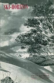
Journal - Ski-Horizon Vol. 2 No 10, June 1951
Ski-Horizon is the official journal of the Federation of Victorian Ski Clubs which began publication in 1949. The original member clubs were Albury Ski Club, Alpine Club of Victoria, Australian Postal Institute Ski Club, Australian Women's Ski Club (Victoria), Beechworth Ski Club, Bogong Ski Club, Bull Lodge Ski Club, Chamois Ski Club, C.S.I.R. Ski Club, Edelweiss Ski Club, Howqua Ski Club, Lazy Eight Ski Club, Melbourne University Ski Club, Melbourne Walking Club, Monsanto Ski Club, Moose Ski Club, Myrtleford Ski Club, Rongbuk Ski Club, Tallangatta and District Ski Club, Tanjil Ski Club, Telemark Ski Club, University Ski Club, Victorian Rover Scouts (B.S.A.), Wangaratta Ski Club, Youth Hostel Association, Yurredla Ski Club. Two pioneers of Falls Creek, Tom Mitchell, M.L.A., and Martin Romuld were Vice-Presidents of the Federation. The journal features stories and events chronicling developments in Victoria and internationally.Ski-Horizon is the official journal of the Federation of Victorian Ski Clubs which began publication in 1949. The were 26 original member clubs which included Albury Ski Club, Bogong Ski Club, Myrtleford Ski Club, Tallangatta and District Ski Club and Wangaratta Ski Club. Two pioneers of Falls Creek, Tom Mitchell, M.L.A., and Martin Romuld were Vice-Presidents of the Federation.This Journal is significant because it documents the early development of skiing in Victoria.The journal features stories and events chronicling developments in Victoria and internationally. Items related to the Falls Creek Area in this publication include:- Page 2: Albury Ski Club is set for a positive year. Present membership of the club is 130 and officials. recently elected are: -President, Mr. Fred Griffith; Vice-President and Booking Officer, Bob Howe; Secretary. Nell Newton; Asst. Sec., Angela Bowler; Treasurer. Sam Roxburgh; Social, Bruce Colquhoun: Trips, June Watson; Bus, Len Egan; Building. John Perger; Equipment, Peter Hadow. Page 3 Toni St. Elmo is planning the monster party the Bogong Ski Club will give at their Falls Creek Lodge on 4th August to the visiting N.Z. team. Page 8 - 9 Article - The Old Order Passes on the Bogong High Plains - an extensive response to the State Development Committee's Report "The Alpine Regions of Victoria; Skiing and Tourist Resorts" and suggestions for the construction of roads, ski tows and other facilities. A sketch map of Falls Creek Village is included.ski history victoria, federation of victorian ski clubs, development of falls creek -
 The Mrs Aeneas Gunn Memorial Library
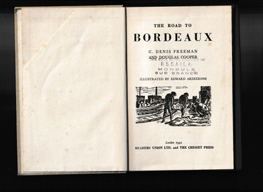
Book, C. Denis Freeman et al, The road to Bordeaux, 1942
... in the French Army in 1940. Ill, maps, p.345. The road to Bordeaux Book ...The story of two Englishmen who enlisted in the French Army in 1940.Ill, maps, p.345.The story of two Englishmen who enlisted in the French Army in 1940.world war 1939-1945 - personal narratives - britain, world war 1939-1945 - ambulance drivers -
Canterbury History Group
Document - Goldings Hall and Alfred Golding, 14/06/1968 12:00:00 AM
History of Alfred Golding's businesses handwritten by R. L. Renwick, includes photocopied map of location of houses and hallsgolding family, renwick> frank, burridge> william (rev.), cuthburt> samuel (rev.), vasey> t., renwick> r. l., balwyn wesleyan church, canterbury literary society, international exhibition sydney 1879 -
Canterbury History Group
Map - Logan Estate, Canterbury
Real estate advertisement distributed by Sinclair & Company of a reproduction of a historical map of the Logan Estate and a short history on the reverse side.canterbury, logan estate, canterbury road, prospect hill road, marlowe street, logan street, canterbury railway station, logan family, sinclair & company, clairmont estate, molesworth street -
Canterbury History Group
Map - Milk delivery areas for Camberwell
Map showing the delivery areas for dairies in Camberwell.camberwell, canterbury, maps, dairies, youngs dairies, goddards dairy -
Canterbury History Group
Document - Canterbury Bowling Club - Agreement, 1935
Agreement between The Mayor, Councillors and Citizens of the City of Camberwell and Messrs A.G. Greenham and A .McK. Hislop, trustees of the Canterbury Bowling Club, 1935. Includes map of land to be occupied.canterbury bowling club, kendall street, city of camberwell, scott street, canterbury gardens, greenham> arthur george, hislop> arthur mckenzie, maps, canterbury -
Canterbury History Group
Document - Deed between the Mayor, Councillors and the Citizens of Camberwell and the Canterbury Bowling Club, 1955
Deed allowing the Canterbury Bowling Club the right to occupy land adjacent to the southern boundary of the bowling green, subject to conditions as set out on the Deed between the club and rhe City of Camberwellcanterbury, canterbury bowling club, kendall street, lawn bowls, city of camberwell, goble> george, maclean> george, etherington> arthur, maps, legal documents -
Canterbury History Group
Document - School Project: Elgar's Special Survey, Tudehope, Jennifer, 1963
Well researched essay on the background of Elgar's Special Survey. Includes mapcanterbury, elgar> henry t., land surveys, boroondara, campbell> j & r, dacre> r, towns> r., sea> h., dyce> a., mccarthy> w.g., shenley> james, henty's paddock, norris> j.r., maling> j, canterbury road, survey road, boroondara roads board, camberwell historical society, mont albert road, brooks> r., land subdivisions -
Canterbury History Group
Map - Canterbury subdivisions, 1996
... Canterbury History Group 190A Canterbury Road Canterbury ...Photocopy of map from Camberwell Library showing Canterbury subdivisions.canterbury, maps, land subdivisions -
Canterbury History Group
Map - Canterbury Subdivisions
A collection of 6 maps with notations showing the names and dates of land subdivision in Canterbury and surrounding suburbs.canterbury, logans estate, shrublands estate, claremount park estate, arklow hill estate, griffin estate, monomeath estate, mont albert park estate, great railway estate, grange estate -
Canterbury History Group
Map - Victorian Railways, Sheet no.10 , Hawthorn to Canterbury, 1/02/1914 12:00:00 AM
Map of Canterbury Railway Station and its surrounds, includes railway lines and station yards and may houses in nearby streets, February 1914.canterbury, canterbury railway station, canterbury road, maling road, bowling green, canterbury gardens, stationmasters houses, scott crescent, victorian railways -
Canterbury History Group
Map - Victorian Railways East Camberwell to Laburnum. Diagram No.3' 58, 1/05/1958 12:00:00 AM
Diagram showing proposed signal and interlocking arrangements for the East Camberwell to Laburnam line 1958canterbury, canterbury station, victorian railways, railway lines