Showing 10723 items
matching site
-
 Bendigo Historical Society Inc.
Document - CENTRAL DEBORAH GOLD MINE - HISTORY OF CENTRAL DEBORAH GOLD MINE 1939 - 1954
4 typed pages of the history of the Central Deborah Gold Mine from 1939 to 1954. Mentions the start of mining at this site and Victor Pabst, who in 1917 recommended that the shaft be deepened. His advice was not acted on for another twenty-two years. Also mentioned is the geology and Method of Mining.mine, gold, central deborah gold mine, central deborah gold mine, history of central deborah gold mine, geology of the central deborah gold mine, method of mining -
 Maffra Sugarbeet Museum
Photograph
The WWI war memorial has since been moved to the front of the RSL Rooms/Maffra Memorial Hall. It is now in front of the Library.A first generation black and white photographic print of the Maffra Sugarbeet Factory in more recent years. It shows the front of the factory from the road, with a fence and some telephone lines and the World War I memorial in the photograph. The sugar store, which is still on site, appears to the nearer end.world war 1914-1918, sugarbeet -
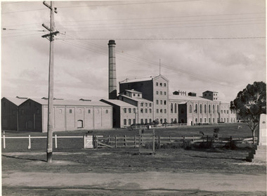
 National Vietnam Veterans Museum (NVVM)
Photograph, Saw Mill 1
A black and white photograph of Engineers working in the saw mill at 1st Australian Task Force, Nui Dat, Phuoc Tuy Province, South Vietnam stack large beams for bridge construction, cut to the respective plan size for delivery to the construction site within Phuoc Tuy Province.photograph, engineers, 1 atf base, nui dat, phuoc tuy province, gibbons collection catalogue -
 Whitehorse Historical Society Inc.
Article, People before profit - land sale opponent, 1992
A community group has criticised Nunawading Council's move to rezone and sell the Vermont South site it uses.A community group has criticised Nunawading Council's move to rezone and sell the Vermont South site it uses. The land is on the corner of Burwood Highway and Livingstone Road which is zoned D 'Public Open Space'. Council has deferred the decision to rezone until after a public meeting.A community group has criticised Nunawading Council's move to rezone and sell the Vermont South site it uses.town planning, city of nunawading, burwood highway, vermont south, livingstone road, vermont south, vermont south -
Whitehorse Historical Society Inc.
Document, Monier Wunderlich Tile Factory, 1989-96
Papers concerning sub-division of the former Monier-Wunderlich Tile Factory site.Papers concerning sub-division of the former Monier-Wunderlich Tile Factory site between Rooks and Mitcham Roads Vermont. Includes City of Nunawading planning documents and correspondence with residents; Wunderlich Residents' Action Group circulars; correspondence and drafts by W & B Gray relating to the proposals.Papers concerning sub-division of the former Monier-Wunderlich Tile Factory site. wunderlich limited, monier-redlands pty ltd, mitcham road, mitcham, rooks road, vermont, nos. 147-157, wunderlich residents' action group, rosstrevor crescent, mitcham, redlands properties, gray, william, gray, beryl -
 Whitehorse Historical Society Inc.
Photograph, Cr. Valda Arrowsmith & L. Fell, C.1987-88
Black and white photo of Cr. Valda Arrowsmith, Mayor of City of Nunawading 1987-88, with Les Fell, C.E.O. of City of Nunawading with Model of Proposed Railway Development. State Government Proposal for West of Springvale Road, Nunawading. Defeated after Council & Community objections as unsuitable site.arrowsmith, valda, fell, les -
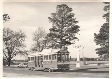 Ballarat Tramway Museum
Photograph - Black & White Photograph/s, Charles Craig, 1971
Yields information about the appearance of the Olympic Monument in Wendouree Parade, Lake Wendouree and the trams that passed by. Black and White photograph of tram of 39 passing the site of the Olympic rings in Wendouree Parade, near Hamilton Ave. Tram has the destination of Gardens via Sturt St West. Shows the lake and the parklands at the time. Photo by Charles Craig - during 1971. Two copies held. trams, tramways, wendouree parade, olympics, lake wendouree, tram 39 -
Canterbury History Group
Ephemera - 8 McGregor Street Canterbury, 2001
Real estate advertisement for the sale by auction of "Ashford" 8 McGregor Street Canterbury, on Saturday 1 September 2001. Includes coloured photographs of the Interior and exterior of the house and floor and site plans. A note on the flyer by Robin Kelly indicates that the property was passed in at $670, 000 and sold later.canterbury, mcgregor street, ashford, edwardian style, maling road -
Canterbury History Group
Ephemera - Prime redevelopement site 250-252 Canterbury Road Surrey Hills, 2004
Real estate advertisement for the sale by auction of two shops at 250-252 Canterbury Road Surrey Hills, on Wednesday 10 March 2004. Includes coloured photographs of front and back of the building, site plan and letter from the agents, Gormankelly, reporting the sale of the property for $800, 000.surrey hills, canterbury road, shops, golden mile canterbury -
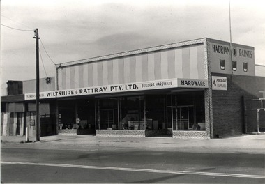 Wodonga & District Historical Society Inc
Photograph - Mann Collection Album - Wiltshire & Rattray Plumbers, C. 1968
Elaine Mann was married to David Mann, a successful Wodonga businessman and community leader who passed away in Wodonga in June 2012. David was a member of the Mann family who began their business in Wodonga in 1920. Elaine was a teacher in Wodonga for many years and an active member of the community.This photo collection is significance as it documents how the businesses and buildings in Wodonga have evolved and contributed to community throughout the late 20th century.Bob Wiltshire and Ron Rattray built this store on the East side of High Street, next to the Railway signal box. The site had formerly been occupied by Abe Turton’s Coach building business. The building has since had several tenants, including “Lunn & Fordyce” clothingwodonga businesses, high st wodonga, wiltshire and rattray -
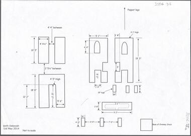 Bendigo Historical Society Inc.
Document - CENTRAL DEBORAH GOLD MINE: NORTH DEBORAH GOLD MINE
BHS CollectionSeven page document with diagrams of the remnant footings of the North Deborah Gold Mine, the South Deborah Gold Mine, Deborah Extended, Deborah Consolidated, Deborah United Deborah Associated. Measurements of footings recorded but sites are not to scale. Researched and drawn by Philip Wilkin and Kay MacGregor, 2014.bendigo, mining, central deborah gold mine -
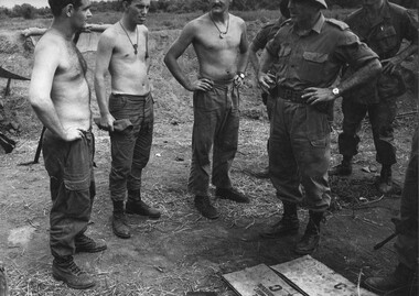 National Vietnam Veterans Museum (NVVM)
Photograph, Gibbons, Denis, Brig Stewart Weir
Denis Gibbons (1937 – 2011) Trained with the Australian Army, before travelling to Vietnam in January 1966, Denis stayed with the 1st Australian Task Force in Nui Dat working as a photographer. For almost five years Gibbons toured with nine Australian infantry battalions, posting compelling war images from within many combat zones before being flown out in late November 1970 after sustaining injuries. The images held within the National Vietnam Veterans Museum make up the Gibbons Collection. A black and white photograph of Route 23, Northwest of the 1st Australian Task Force (1ATF) base at Nui Dat, The ATF Commander Brig. Stewart Weir talks to Engineers working at bridge site. The bridge foundations had been damaged, by water, during a heavy rain storm.photograph, brig stewart weir, 1st atf base, 1st field sqn engineers, gibbons collection catalogue, national route 23, nui dat, engineers, commander, denis gibbons -
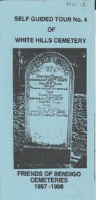 Bendigo Historical Society Inc.
Document - BENDIGO CEMETERIES COLLECTION: SELF GUIDED TOUR NO. 4 DOCUMENT
BHS CollectionBlue coloured trifold document: Self guided Tour No. 4 of White Hills Cemetery. Friends of Bendigo Cemeteries 1997 - 1998. Theme : tombstone preservation. Numbered grave sites with descriptions - demonstrates tombstones that have been maintained or repaired by descendants, groups, stonemasons, friends and the Friends.Friends of Bendigo Cemeteriesbendigo, cemetery, white hills cemetery tour -
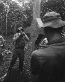 National Vietnam Veterans Museum (NVVM)
Photograph, Gibbons, Denis, Long Tan Cross Dedication 1
Denis Gibbons (1937 – 2011) Trained with the Australian Army, before travelling to Vietnam in January 1966, Denis stayed with the 1st Australian Task Force in Nui Dat working as a photographer. For almost five years Gibbons toured with nine Australian infantry battalions, posting compelling war images from within many combat zones before being flown out in late November 1970 after sustaining injuries. The images held within the National Vietnam Veterans Museum make up the Gibbons Collection. A black and white photograph of Long Tan, Phuoc Tuy Province, South Vietnam, 18/08/1969. A digger from 6th Battalion/New Zealand (ANZAC) Royal Australian Regiment, sites in the cross of remembrance using a compass whilst facing directly at the area of the bloody battle.photograph, long tan cross, phuoc tuy province, 6th battalion, 4rar nz, royal australian regiment, gibbons collection catalogue, denis gibbons, photographer, vietnam war, digger, long tan cross dedication -
 Whitehorse Historical Society Inc.
Photograph, Orchard at Blackburn
Black and white photograph of Pearce family orchard at site of present Blackburn High School. Photo taken by photographer from Commonwealth Department of Trade and Commerce using professional models. Photo taken for overseas trade publicity professional models. Photo taken for overseas trade publicitypearce, ronald, harry, edward h., blackburn high school, orchard, australia. department of trade and commerce -
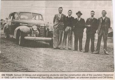 Bendigo Historical Society Inc.
Newspaper - JENNY FOLEY COLLECTION: ON TOUR
Work started on the Lauriston Reservoir in 1939 as part of the Coliban water system and was officially opened by Victorian Premier, Albert Dunstan in 1941. Capacity was increased in 1946 when steel spillway gates were added. Although these had been part of the original design they could not be added at the time of the building because of post-war steel shortages.Bendigo Advertiser ''The way we were'' from 2003. on tour: school of mines civil engineering students visit the construction site of the Lauriston Reservoir in 1940. Left to right: Les Nankervis, Ron Watts, instructor Syd Power, an unknown student and Cliff Binks. The clip is in a folder.newspaper, bendigo advertiser, the way we were -
Port Melbourne Historical & Preservation Society
Audio - PMHPS Meeting, Richard and Andrew BUXTON, Glen Stuart, 1995
Recording of PMHPS meeting on 27.11.1995. Recorded by Glen STUART at the Liardet Community Centre. Speakers were Richard and Andrew BUXTON. Discussing family history of Buxtons and Buckhursts, re development of Swallow and Ariell site. Period covered 1830s to 1995. Recording duration 01:15:28.families, built environment - commercial, swallow & ariell ltd, richard buxton, andrew buxton, buckhurst family, buxton family -
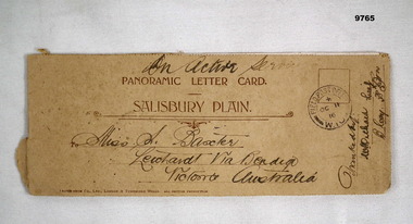 Bendigo Military Museum
Card - PANORAMIC LETTER CARD, Hotocrom Co. Ltd, c.1916
Sent home by Capt. Frederick Baxter MC. Part of the Baxter Collection. Refer Cat No.4219.Cream colour panoramic card Salisbury Plain. Inside 4 pages with 8 images of Army Barracks or tourist sites. On front is address sent to in Australia, Post Office stamp and signed off by Battalion. Photos are all labelled as per inscription and held together by one staple.Photo's labelled. Top written "On Active Service". 1. 40857 Bulford Camp. 2. 48060 Bulford Camp B Lines. 3. 36891 Bulford Camp near Salisbury. 4. 36868 Salisbury Plain, Tidworth Barracks. 5. 36889 Bulford The Bridge. 6. Amesbury, Queensbury Bridge. 7. 32482 Salisbury Stonehenge. 8. 32478 Salisbury Cathedral.letter card, baxter collection, ww1, baxter mc -
 St Kilda Historical Society
Photograph, 'Glen Huntley' 150th anniversary of arrival - images collection
Victorias first quarantine station was established in Port Ormond on 24 April 1840 when the government immigrant ship "Glen Huntley" arrived in the Port Phillip District flying the yellow quarantine flag . The site is marked by a cairn and plaque that was unveiled in 1985. In 1990 a second plaque was affixed to the cairn to mark the 150th anniversary of the arrival of the ship. It was unveiled at a gathering of descendants of the original passengers on 22 April 1990 by the oldest known descendant, Albert John Buntine MM.Colour photographInscription on 150th anniversary plaque: This plaque commemorates the 150th anniversary of the arrival of the ship 'Glen Huntley' at a gathering of descendants of the original passengers. Unveiled on April 22nd 1990 by Albert John Buntine MM, aged 95. Oldest known descendent. Anderson, Davidosn, Dingwall, McCleery, McDougal, McIntosh, Pattison, Somerville, Brisbane, Kirkwood, McGaskell, McDonald, McGregor, McKenzie, Turnbull, Walker, Armstrong, Henderson, Mathewson, McPherson, Robertson, McKinnon, Whitlock, Stewart, Cameron, Cummins, Hewison, Maskill, Mathers, McKinan, McKinny, McLaren, Burnie, Clarke, Denham, Fraser, Harper, Mercer, McColl, McLeod, Clarke, Duff, Roy, Seat, Stow, Tait, Ward, Craig, Grant, McKay, Mefan, Munro, Nicol, Smith, Young. The plaque marking the 150th anniversary of the ship's arrival was placed below the plaque that was attached to the cairn in 1985. The inscription on the original plaque is: This cairn marks the site of Victorias first quarantine station, which was established on the 24th April 1840 when the government emigrant ship "Glen Huntley" arrived in the Port Phillip District flying the yellow quarantine flag. The site became St Kilda's first official burial ground and the graves of the early colonists remained here until 1898 when the remains were re-interred in the St Kilda Cemetery. Unveiled by the Hon. R W Walsh MLA Member for Albert Park, Minister for Public Works, Assistant Minister for Employment and Industrial Affairs, 7th November 1985. This project was initiated by the Historical Society of St Kilda and sponsored by the Lions Club of Elwood for the 150th Anniversary of the State of Victoria. Logo Victoria 150.glen huntly, glenhuntly, albert john buntine, elwood, point ormond, glen huntley -
 Phillip Island and District Historical Society Inc.
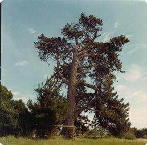
Photograph, 1978/79
This commemorates the site of Fort DumaresqPhotograph of Pine tree which marks the spot where Capt. Wright established a fort in 1826.local history, photographs, historical, memorial (pine tree), coloured photograph, john cook, phillip island, fort dumaresq -
Clunes Museum
Document - NEWSPAPER CUTTING AND HISTORICAL GUIDE, WHAT TO LOOK FOR IN AND WHERE TO FIND IT, 1971/1972
HISTORY LOCATIONS CLUNES SITES.1 NEWSPAPER CUTTING CLUED ONTO PAPER - HISTORY OF CLUNES .2 3 X PAGES AND MAP DETAILING PLACES OF INTEREST IN CLUNESlocal history, places of interest clunes -
Tatura Irrigation & Wartime Camps Museum
Knife - table
Found at site of camp 4.Sheffield silver plate table knife -
 Kilmore Historical Society
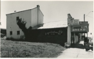
Photograph, 13 Sydney Street, 1970's
Was the site of J. Quinn Bakery.20cm x 12.5cm black and white photograph of the Breakells Bakery and shop at 13 Sydney Street. This photo was taken from the south side of the building. Pictured is the shopfront, the outside of the single story shop building and a light coloured two story building in a the back of the shop building. On the side of the building advertising for "Kayes Hair Boutique". At the front of the shop there is a sign for "Hot Food". And on the awning of the shop there are multiple signs including: "Milkbar", "Streets ice cream" and "Fresh bread, pies & pasties". Printed on standard card stock.Written on the back: 486 14-86-35bakers, baker and bakeries, bakeries, 1970's -
 Kilmore Historical Society
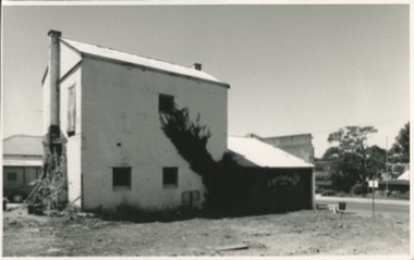
Photograph, 13 Sydney Street, 1970's?
Was the site of J. Quinn Bakery20cm x 12.5cm black and white photograph of the south side and rear of Breakells Bakery and shop. At the rear of the shop the wall was demolished in part to remove the oven from the bakery. On the second story of the back building a crude wooden door. Written on the back: 487 14-86-36bakers, bakeries, bakers and bakeries, bakery -
Stawell Historical Society Inc
Photograph, Stawell Gold Mine, Aerial Photomap of Stawell & Mining 1997, 1997
Evaporation Dams Mining SiteLarge Laminated Aerial Photo Map showing Stawell and Mining activityMining Geology Office 1997mining -
 Buninyong & District Historical Society
Photograph - Pulpit Rock at Magpie, Colour photograph of Pulpit Rock at Magpie
Historic sites. Magpie village.In excellent condition, very clear picture.Pulpit Rock, Magpie, 27 November 1994pulpit rock. site of magpie village., taken during a historic visit in 1994. -
 Vision Australia
Photograph - Image, St Kilda Road building in 2010, 6/1/2010
In 2007, Vision Australia sold it's iconic 557-563 St Kilda Road site. The historic bluestone building was in need of renovation and repair, had limited space for staff and clients and with more demand for services in suburban and regional areas, did not meet the needs of the national organisation. The purchaser was mainly interested in the Ormond Hall section, which they sub-divided off and sold to the tenant of the Belgian Beer Cafe. The remainder of the site was then sold on to another developer. Unable to quickly proceed with their plans on developing the site for residential buildings, the site fell into some disrepair in the interim which was when these images were taken. Later the site was sold again and residential buildings now occupy part of the block. 20 images taken of and from St Kilda Road buildingroyal victorian institute for the blind, buildings, myer house, ferguson and urie -
 Wodonga & District Historical Society Inc
Album - Hume Reservoir Australia Album - Driving first row of piles for coffer dam across the river, December 1925
This set of photos is from a leather bound album bearing the inscription "HUME RESERVOIR AUSTRALIA" plus 'The Rt. Hon. L. C. M. S. Amery, P. C., M .P.' all inscribed in gold. It was presented to The Rt. Hon. L. C. M. S. Amery, P. C., M. P, Secretary of State for Dominion Affairs on the occasion of his visit to the Hume Reservoir on 2nd November 1927. This album is of local and national significance as it documents the planning and development of the Hume Reservoir up to 1927. It was the largest water reservoir in the British Empire. The album records the pioneering engineering work that went into its construction.DEPARTMENT OF PUBLIC WORKS, N.S.W. RIVER MURRAY WATERS SCHEME. HUME RESERVOIR. 19. Driving first row of piles for coffer dam across the river. New South Wales. December 1925. Cofferdams are temporary structures used where construction is being carried out in areas submerged in water. They are most commonly used to facilitate the construction or repair of dams, piers and bridges. To divert the river, a Coffer Dam was built across the old bed above and below the Dam site and tying into the end of the concrete wall built inside the levee bank. This completely surrounded the remainder of the site of the Dam and south wing wall, including an area of 12½ acres. hume reservoir australia, river murray waters scheme, hume reservoir construction -
 Ballarat Heritage Services
Photograph - Photograph - Colour, Clare Gervasoni, Carisbrook Police Lockup, c1998, c1998
The Logs at Carisbrook was the major gaol in the extensive Carisbrook Police District until 1858, and remained Carisbrook's gaol for low key offenders until about 1900. The lockup was registered by the National Trust on 22/10/1964.Colour photograph of the Carisbrook Police Lockup The Police staton was originally known as the Loddon Punt opening in 1851. The lock up was completed in October 1854 by James Corbet at a cost of 380 pounds. Standing in the park beside Bucknall Street it is the town's one significant historic building. It was originally built on the police paddock adjacent to the primary school and moved to its present site in 1886. The walls are made of interlocking horizontally-laid logs. The shingle roof has been replaced with corrugated iron. The lockup was built on site from local materials, and opened in 1851. It was moved to its current position ofter the original locationn flooded. The police station was closed in 1941. carisbrook, carisbrook lockup, carisbrook police lockup, log cabin, police, police paddock, the logs -
 Ballarat Tramway Museum
Photograph - Colour Photograph/s - set of 15', Austin Brehaut, 1/04/2000 12:00:00 AM
Yields information about various locations in Ballarat in March 2000 for comparison with previous photographs.Set of 15 colour photographs taken by Austin Brehaut in April 2000 showing various locations that Ballarat trams once ran in, for use in a BTM presentation, named "Ballarat Past and Present" at the COTMA 2000 Ballarat Conference. All on Fujicolour Crystal Archive Paper. On rear in blue ink is the date, location and where relevant a reference number to photo locations that the author of the presentation had requested. Letter from Austin, filed with this worksheet. 1772.1 - Sebastopol terminus, 4/4/2000 .2 - Albert St. Sebastopol near "crossover" - 4/4/2000 .3 - Old depot site, 5/4/2000 .4 - From depot site at Depot junction - 5/4/2000 .5 - Albert St. Sebastopol, looking south above loop site - 5/4/2000 .6 - Mt. Pleasant line, in Barkly St. towards terminus - 5/4/2000 .7 - Mt. Pleasant terminus, Cobden Cnr. - 5/4/2000 .8 - Wendouree Parade at Macarthur St. - 5/4/2000 .9 - Site of old Power Station Cnr Ripon St. Wendouree Parade .10 - Sturt St. at Dawson St (site of crossover) towards former Golden City Hotel - 6/4/2000 .11 - From Grenville St - up Sturt St. hill - 6/4/2000 .12 - Lower Sturt St. toward Grenville St - 6/4/2000 .13 - Railway Station from Signal box - 27/4/2000 .14 - Lower Sturt St. toward Grenville St - 6/4/2000 .15 - Railway Station from Signal box - 27/4/2000 For 2010 comparisons see 4645 and 4646. See Aboveballarat, sebastopol, albert st, sec depot, railway station, mt pleasant, dawson st, sturt st