Showing 22306 items
matching parks
-
 Kew Historical Society Inc
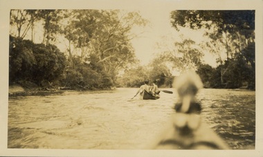
Photograph - Victorian Canoe Club, Through the rapids, 1920-30
Canoeing on the River Yarra at Melbourne was an important and widespread recreational pursuit for Melbournians, especially in the first half of the twentieth century. The Victorian Canoe Club was formed in 1912 at a meeting in Melbourne and its first committee elected in the same year. Records indicate that the Club continued into at least the 1950s .The album has historic and social significance as a record of recreational activities (as well as canoe making) in the early years of the twentieth century. It has local significance as the site of the headquarters of the Club was in Studley park. A number of photographs in the album provide vistas of Kew on the Yarra that are otherwise unavailable.One of 24 labelled photos in part album, originating from the Victorian Canoe Club, which had its headquarters in Studley Park, Kew. The album includes a photographic record of canoe construction and also locations in Studley Park and Kew where the canoes were used. The subject of this photograph is identified as 'Through the rapids' with two men and a boy in the first canoe travelling through rapids with another canoe following from which the photograph is taken. "Through the rapids"victorian canoe club, river yarra, studley park, canoe clubs, canoeing, recreation -- canoeing -
 University of Melbourne, Burnley Campus Archives
Plan, Royal Horticultural Society's Garden
Changed boundaries of the site burnley gardens, survey paddock, flood, lynch design, richmond park, yarra river -
 Melbourne Tram Museum
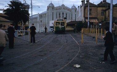
Slide, Keith Kings, 15/08/1959 12:00:00 AM
Colour slide, Kodak, white cardboard of ex VR No. 52 using the Luna Park Loop, St Kilda during an AETA tour, 17/10/1959. Has the Palais Theatre in the background. Tram has an auxiliary board of "Luna Park", would appear that the AETA auxiliary board is in the cab. An Inspector is shutting the gate behind the tram, while other people are watching the wheels etc. Slide Number K(i)(282)Extensive handwriting on rear in ink.trams, tramways, vr class tramcars, luna park, loops, aeta, tours, tram 52 -
 Kew Historical Society Inc
Plan, Melbourne and Metropolitan Board of Works, Melbourne & Metropolitan Board of Works : Borough of Kew : Detail Plan No.1294 & 1295, 1904
The Melbourne and Metropolitan Board of Works (MMBW) plans were produced from the 1890s to the 1950s. They were crucial to the design and development of Melbourne's sewerage and drainage system. The plans, at a scale of 40 feet to 1 inch (1:480), provide a detailed historical record of Melbourne streetscapes and environmental features. Each plan covers one or two street blocks (roughly six streets), showing details of buildings, including garden layouts and ownership boundaries, and features such as laneways, drains, bridges, parks, municipal boundaries and other prominent landmarks as they existed at the time each plan was produced. (Source: State Library of Victoria). This plan forms part of a large group of MMBW plans and maps that was donated to the Society by the Mr Poulter, City Engineer of the City of Kew in 1989. Within this collection, thirty-five hand-coloured plans, backed with linen, are of statewide significance as they include annotations that provide details of construction materials used in buildings in the first decade of the 20th century as well as additional information about land ownership and usage. The copies in the Public Record Office Victoria and the State Library of Victoria are monochrome versions which do not denote building materials so that the maps in this collection are invaluable and unique tools for researchers and heritage consultants. A number of the plans are not held in the collection of the State Library of Victoria so they have the additional attribute of rarity.Original survey plan, issued by the MMBW to a contractor with responsibility for constructing sewers in the area identified on the plan within the Borough of Kew. The plan was at some stage hand-coloured, possibly by the contractor, but more likely by officers working in the Engineering Department of the Borough and later Town, then City of Kew. The hand-coloured sections of buildings on the plan were used to denote masonry or brick constructions (pink), weatherboard constructions (yellow), and public buildings (grey).The streets and built structures in MMBW Detail Plan 1294 & 1295 were surveyed in 1903 and released to contractors in 1904. This plan is one of two in the collection where the lithographers amalgamated two separate plans. Both plans include sections of Studley Park. Dominating the south and west corners of Kew Junction are the Clifton and Kew Hotels. The Kew Hotel, owned by Patrick O’Shaughnessy was one of the oldest in Kew. MMBW plans were amended over time to take account of new subdivisions such as that which created Merrion Place. Of the four mansions shown in Studley Park Road, three remain – ‘Field Place’, the home of Frances Henty, ‘Leaghur’ and ‘Darley’. ‘Byram’ (later ‘Goathland’, then ‘Tara Hall’) was an architectural marvel. Designed in 1888 by E.G. Kilburn for the paper magnate George Ramsden, it was demolished in 1960. While an earlier sale of the southern section of Byram had created Tara Avenue in 1927, the demolition of the house in 1960 enabled the extension of Tara Avenue northward.melbourne and metropolitan board of works, detail plans, mmbw 1294, mmbw 1295, cartography -
 Eltham District Historical Society Inc
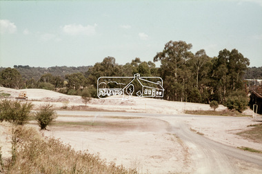
Slide, Construction of Eltham Town Park, 22 Feb 1974
Construction of Eltham Town Park, later renamed Alistair Knox Park. View looking across the front of Shillinglaw Cottage and what was to be developed as the Eltham Town Common (now the site of the Eltham Library) across to the Eltham Town Park development. To the right is the Eltham Trestle Bridge and to the left what was once the overflow site for the Susan Street Tip.35 mm colour positive transparency Mount - Agfacolor Service (Blue)alistair knox park, eltham town park, eltham tip, eltham town common, eltham trestle bridge -
 Falls Creek Historical Society
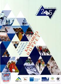
Poster - Kangaroo Hoppet 2015
The Kangaroo Hoppet is Australia’s premier long distance cross country ski race, and a member of the Worldloppet series of international cross country ski events. The first race at Falls Creek was held in 1979 under the name of “Australian Birkebeiner”. It was a 21km race with about 80 participants organised by the Birkebeiner Nordic Ski Club of Mount Beauty. The course started and finished at Falls Creek Alpine Resort and took participants out into the Bogong High Plains. After running the event for 10 years, it was decided they should become part of the Worldloppet series of marathon ski races. Representatives from the Birkebeiner Nordic Ski Club and the Australian Ski Federation attended the Worldloppet Annual Meeting in Finland in June 1990 to put the case for the acceptance of an Australian event into the Worldloppet series. Before being admitted, they had to demonstrate that the Birkebeiner Club could run a world class event, so three months later in August 1990 a 42km event named the Australian International Ski Marathon was held at Falls Creek together with a 21km Birkebeiner race and a 7km event called the Birkebeiner Lite. The event was approved by delegates from USA, Norway and Austria, in 1991 Australia became the 12th member of Worldloppet, with the condition that there had to be a name change. After some late night discussion allegedly involving red wine from North East Victoria the main event became the 42km Kangaroo Hoppet, with the minor events being the 21km Australian Birkebeiner, and 7km Joey Hoppet. In the winter of 1991, the first Kangaroo Hoppet was held. It was a great success and has been a regular fixture on the international ski calendar ever since. It features the main 42km event as well as a 21km event and a 7km event. The Hoppet brings the Australian snowfields to an international audience. In 2015 the Men's Winner was Valerio Leccardi from Switzerland in a time of 01:31:10.910. The winner of the Women's event was Maria Graefnings of Sweden in a time of 01:39:05.63. Due to the thick fog and extremely poor visibility, the course was shortened to two 18km laps to avoid the open areas of the Park and Heathy Spur.This poster is significant because it documents an event which brings international attention to Falls Creek and the surrounding region.A poster featuring a diamond pattern containing images of skiers. The date of the event is contained in two linked diamonds in the top right hand corner. Logos of AGL, Falls Creek All Season Alpine Resort, Alpine Shire, Tourism Victoria, Parks Victoria and the Birkebeiner Nordic Ski Club are across the bottom of the poster.Top Right: Saturday 22 August 2015 CELEBRATING 25 YEARS Within the diamond shapes: 7 km - 21km - 42 km FALLS CREEK AUSTRALIA KANGAROO HOPPET Below the skier: www.hoppet.com.au kangaroo hoppet, worldloppet events, falls creek, mt. beauty -
 Stawell Historical Society Inc
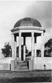
Photograph, Pioneers’ Memorial on Big Hill -- 3 Photos
Three black and white photos of Pioneers Memorial Stawell. The larger of the 4 photos is a Post card and taken earlier than the other 3 photos as there is a plastic milk crate over the area where the direction indicator was later placed. This photo also has "Chapman photo Stawell" stamped on the print. Two of the smaller photos show the Pioneer Memorial at a distance with people standing between the memorial and a bus parked to the left of the photograph. One of these two photos has a white seat on the right side. The fourth photo has "Murray View No. 8 Pioneers' Memorial, Stawell Vic". printed on the photograph of the Pioneers' Memorial. Each of the these 3 smaller photos have the direction indicator under the dome.Three black and white photos of Pioneers Memorial Stawell. The larger of the 3 photos is a Post card taken earlier than the other 2 photos as there is a plastic milk crate over the area where the direction indicator was later placed. This photo also has "Chapman photo Stawell" stamped on the print. Two of the smaller photos show the Pioneers' Memorial at a distance with people standing between the memorial and a bus parked to the left in the photograph. One of these two photos has a white seat on the right side. Each of the 2 smaller photos have the direction indicator under the dome.Chapman Photo Stawell (right bottom corner). Post Card printed on the back and also a stamp "Stawell district - Pioneer's Memorial - written inside the stamp is "Every blade of grass that grows And mullock heap and tree, Speak of Old days, the Good days, And times that used to be"stawell -
![Photograph - Digital image, Marilyn Smith, Fallen Soldiers Memorial [base], 17/12/2013](/media/collectors/4f729f5697f83e03086015b8/items/585b6a88d0ce291268060ca7/item-media/585b6ad4d0ce291268061e6c/item-fit-380x285.jpg) Greensborough Historical Society
Greensborough Historical SocietyPhotograph - Digital image, Marilyn Smith, Fallen Soldiers Memorial [base], 17/12/2013
A recent photo of the base of the Fallen Soldiers Memorial. The Memorial was originally sited in Main Street, moved to Lower Park and eventually to its present position in Greensborough War Memorial Park.This memorial was raised by subscription from residents and bears the names of soldiers who were killed in World War 1.Colour digital photographfallen soldiers memorial greensborough, greensborough war memorial park -
 Greensborough Historical Society
Photograph - Digital image, Marilyn Smith, Mont Park: Ernest Jones Hall, 30/07/2017
Mont Park: Ernest Jones Hall. One of a collection of photographs of the original buildings at the Mont Park Hospital site. This was a combined chapel and entertainment hall, built between 1927-1930.Digital copy of 2 colour photographsmont park hospital, ernest jones hall -
 Eltham District Historical Society Inc
Photograph, Eltham Town Park (previous tip site)
One of a set of display images thought to be produced by the Shire of Eltham c.1979-1987. The Eltham Town Park was a reclaimed tip site. It was later named the Alistair Knox Park Illustrative of services provided by former Shire of ElthamColour photograph 20 x 29 cm mounted on green-painted cardboard 25.5 x 30.5 cmTitle printed on label adhered to board below photograph (replaced June 2017)eltham town park, alistair knox park -
 Whitehorse Historical Society Inc.
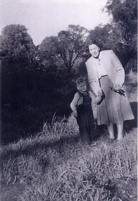
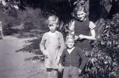
Photograph, Antonio Park - Doris Harris, C1960
The photo is part of a set provided by Robin Harris of his early life (1953-1962) in 'The Shack' at Antonio Park. See ND5241 for his story 'When Antonio Park was home'.)Black & white photograph of Doris Harris (1900-1975) with her grandson, and Robin Harris's nephew, Mark Coleclough. Photo was taken from the eastern side of the shack looking toward Deep Creek Road and showing part of the overgrown fruit orchard in the background. See ND5241 for history.antonio park mitcham, harris. dorothy, coleclough. mark, the shack, whitehorse road, mitcham, no.627, harris. robin, bushfire - 1962 -
 Whitehorse Historical Society Inc.
Photograph, Antonio Park - The Harris Children, C1960
The photo is part of a set provided by Robin Harris of his early life (1953-1962) in 'The Shack' at Antonio Park. See ND5241 for his story 'When Antonio Park was home'.)Black & white photograph of of Robin Harris, nephew Mark Coleclough and sister Margaret Julie Harris. See ND5241 for history.antonio park mitcham, coleclough. mark, the shack, whitehorse road, mitcham, no. 627, harris. robin, harris. margaret julie, bushfire - 1962 -
 Wonga Park Community Cottage History Group
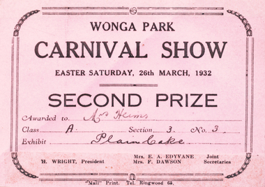
Photograph (sub-item) - Certificate recording a winner at Wonga Park’s Easter Show in 1932 – Mrs. Heims for a ‘plain cake’! This show was an annual event for many years in Wonga Park. Certificate in original colour
Certificate recording a winner at Wonga Park’s Easter Show in 1932 – Mrs. Heims for a ‘plain cake’! This show was an annual event for many years in Wonga Park. Certificate in original colour. -
Ringwood and District Historical Society
Miners Right, 1926 Miners Right - J H Hartley, Wonga Park, 16-May-25
Miners Right No. 11016 - cost 2 Shillings and 6 Pence dated 16 May 1926. Issued to J H Hartley of Wonga Park. +Additional Keywords: Hartley, J HAs above -
 Ringwood and District Historical Society
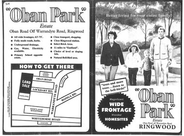
Flyer, Land Sale Advertisement, Oban Park Estate, Ringwood, Vic. - 1969
One double-sided and two single-sided pages advertising Oban Park Estate land sale, including terms of sale, locality map, subdivision features and summary of local services.Subdivision includes Oban Road, Terrigal Close, Dorelaw Drive (later Melview Drive), Naroo Court, Barook Court, and Lockhart Road. Agents in Conjunction: E. Wachman, Melbourne, Hutchinson Real Estate, Ashwood, and A.W. Dickson, 136 Whitehorse Road, Ringwood (Phone) 870-6007 A.H. 882967. Separate newspaper advertisement (digital only) shows agents - Hutchison Real Estate (Telephone 277-2326) and Michelson Gelfand Pty Ltd (Telephone 53-8151). -
 Lara RSL Sub Branch
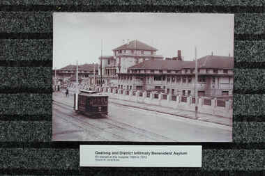
Photograph - Post World War 1 Photographs of Hospitals, Geelong and District Hospital 1909-12, Mont Park Hospital, Randwick Military Hospital 1919
Returning wounded soldiers from World War 1 and hospital information,Hospital ans patient data for 918-1919Photos of Geelong Hospital 1/ dated 1909-1912 2/ Dated 1930, 3/ Mont Park Hospital dated 1918, 4/ Randwick Military Hospital Sydney dated 1919Photos also come with notation padsgeelong hospital, mont park hospital, randwick military hospital -
 Halls Gap & Grampians Historical Society
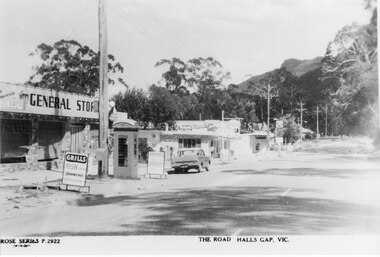
Postcard - B/W, C 1960s
Thomson's and Taylor's stores, with Halls Gap Hall further along the street.the postcard shows a strip of shops, including a general store, along a bitumen road. There is a phone box on the roadside and a Holden car parked in front of the stores. A wooded range can be seen in the background.buildings, shops -
 Halls Gap & Grampians Historical Society
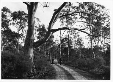
Photograph - B/W, C 1960s (?)
The photo shows two people walking away from camera towards a Holden station-wagon parked on a gravel road. A large gum tree stands in the foreground on the left side of the photo.access routes, roads -
 Halls Gap & Grampians Historical Society
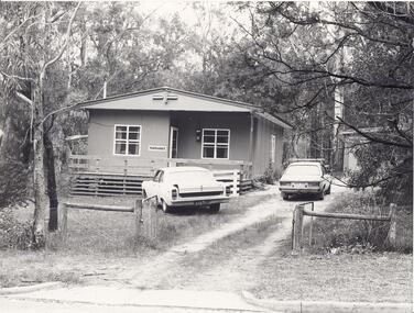
Photograph - B/W
"Yarrabee" a holiday house in Halls Gap which was formerly a staff house for the construction of Bellfield Dam. A number of this houses were transported from job to job.A fibro cement house of simple rectangular construction, a low pitched roof ,sashed windows, a garage appears at the end of the driveway. Two cars are parked in driveway, gum trees surround the house. buildings, houses -
 Victoria Police Museum
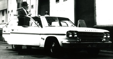
Photograph (police car)
Wireless Patrol Rambler Classic, registration number JNC-003, with light on roof. The car is parked and all doors are open, with the driver Graeme Dovaston standing on the driver's side. Circa 1967police vehicles; motor transport branch; motor transport section; wireless patrol; highway patrol; rambler classic car; dovaston, graeme -
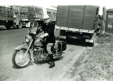 Victoria Police Museum
Photograph (police motorcycle)
Ariel motorbike, registration number CC-434, and rider parked near a number of empty livestock trucks. On the right hand side is a telephone pole and wooden telephone box. Circa 1960.police vehicles; wireless patrol; motor transport branch; motor transport section; police motorcycles; ariel motorcycle -
Glenelg Shire Council Cultural Collection
Photograph - Photograph - View of Portland Harbour and port, c. 1980
Port of Portland Authority archives.Front: (no inscriptions) Back: (no inscriptions)port of portland archives, portland harbour, lighthouse, caravan park, south portland, aluminium smelter -
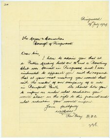 Ringwood and District Historical Society
Letter, Citing Ringwood Bowling Club's formation and requesting Council for occupancy of Bamford's Park
1929 saw the establishment of the Ringwood Bowls Club initially located on the land now occupied by the Eastland Shopping Centre. It moved to its current location in Loughnan Road, Ringwood in 1997.Hand-written letter from the Hon. Secretary of the Ringwood Bowling Club to Borough of Ringwood Mayor and Councillors requesting the terms and conditions of occupying Bamford's Park. Dated 19th July 1929.city of ringwood bowls club, ringwood bowling club, ringwood bowls club, lawn bowls, bowling -
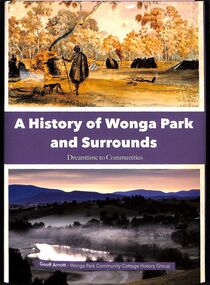 Ringwood and District Historical Society
Book, Geoff Arnott, A History of Wonga Park and Surrounds - Dreamtime to Communities by Geoff Arnott, 2022, 2022
Large hard cover book consisting of Muli-coloured dust jacket, but printed in black and white, with many photographs, 345 pages. Copyright Wonga park Community Cottage History GroupISBN 978-0-646-86659-8 -
 Bendigo Historical Society Inc.
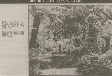
Newspaper - JENNY FOLEY COLLECTION: LUSH
Bendigo Advertiser ''The way we were'' from 2000. Lush: the fernery in Rosalind Park gives Bendigo a taste of the rainforest. The scenic location was captured on film in the early 1900s. The clip is in a folder.newspaper, bendigo advertiser, the way we were -
 Bendigo Historical Society Inc.
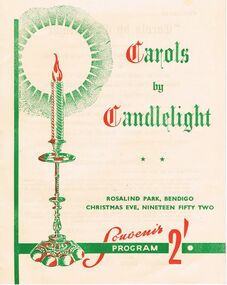
Document - LYDIA CHANCELLOR COLLECTION; CAROLS BY CANDLELIGHT PROGRAMME
A cream programme with red and green print. Titled 'Carols by Candlelight. Rosalind Park, Bendigo Christmas Eve, Nineteen Fifty Two. Souvenir Program 2'. Cambridge Press, Bendigo.1952.event, music, singing, lydia chancellor, collection, event, christmas, celebrations, music, singing, carols, rosalind park -
 Bendigo Historical Society Inc.
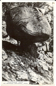
Photograph - BASIL MILLER COLLECTION: MUSHROOM ROCK MT. BUFFALO NATIONAL PARK
Black and white photograph of 'Mushroom Rock' at Mt. Buffalo National park. Inscriptions on reverse: Postcard, correspondence, address only, single vertical line, square formed using the name 'Kodak'.person, individual, basil miller -
 Bendigo Historical Society Inc.
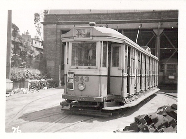
Photograph - BASIL MILLER COLLECTION: TRAM 943
Tram 943 parked at depot, sign advertising Marie Clair Brandy on front of tram. 'LB Many Collection No32' on back, also '(30)' written in blue ink on back of photo.person, individual, basil miller -
 Bendigo Historical Society Inc.
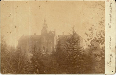
Photograph - CAMP SCHOOL SANDHURST
sepia photo: Camp School, Sandhurst; Photo taken from Rosalind Park looking north towards school. Trees in foreground. School now known as Camp Hill Primary School.place, building, camp school sandhurst -
 Bendigo Historical Society Inc.
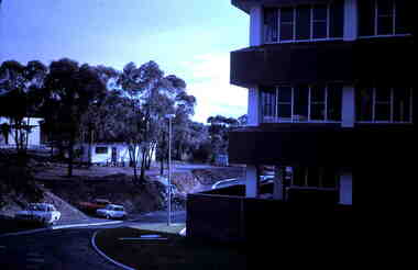
Slide - RALPH BIRRELL COLLECTION: EIG SCHOOL, c1974
EIG School - Ralph Birrell Collection. - Construction of Latrobe Uni. C1970. Bendigo Institute of Technology, Engineering School, Applied Science. Cars parked at the newly formed road around the university.Kodakeducation, tertiary, latrobe university bendigo, eig school - ralph birrell collection. - construction of latrobe uni. c1970. bendigo institute of technology, engineering school, applied science. cars parked newly road university