Showing 11366 items matching "land-clearing"
-
 Surrey Hills Historical Society Collection
Document, Copy of title, 391 Mont Albert Road, Surrey Hills
Victoria Melba Turner (known as Melba) and Elizabeth Maitland Anderson trained together at the Melbourne Hospital, completing their training just months apart; Melba in October 1914 and Elizabeth in May 1915. Both were registered on 31.3.1925 and listed at 391 Mont Albert Road, the site of Mosgiel Private Hospital. Note that the road was subsequently re-numbered and became 293 Mont Albert Road. 391 Mont Albert Road had previously been the home of the Sherar family and had originally been built for Charles J Currie, a solicitor. Three pages relating to the title of 391 Mont Albert Road. Historical search statement from Land Use Victoria is dated 15/09/2020. The reference is Vol 5414, Fol 1082747. 391 mont albert road, victoria melba turner, amy lillian hughes, muriel harper gilchrist, mosgiel hospital, 293 mont albert road, sherar family, charles j currie, quamby, elizabeth maitland anderson -
 Surrey Hills Historical Society Collection
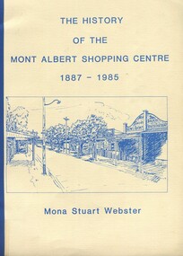
Book, Box Hill Historical Society et al, The history of the Mont Albert Shopping Centre, 1986
Born in 1900, Mona was the daughter of Florence Jane McDowall Stuart (1867-1936) and George Hudson Grant (1864-1910) who married in 1899. He was a surveyor and they lived in Albany Crescent, Surrey Hills. Her full name was Jessie Mona Stuart Grant and she had a sister Mollie. In 1924 she married Clarence William Willoughby Webster (1895-1980) - SERN 33286. Clarence was born in Thorpedale where his father was a teacher. He was living in View Street Mont Albert and was a law student when he enlisted on 3 October 1916. After discharge on 10 May 1919, Clarence returned to his studies. He joined a legal firm in the city which became Pearce & Webster (later Pearce Webster Dugdale). Mona and Clarence lived in Surrey Hills and Mont Albert in a number of homes for the remainder of their lives.A history of the Mont Albert Shopping Centre in Hamilton Street, Mont Albert, including the early land use, and a chronology of shop owners. Index, photos., 39p. Compiled by local resident, Mona Webster.On front cover: top RH corner "Kay Kirkwood/98995158"phoenix park estate, mont albert, hamilton street, (mr) - mckerdy, (mr) - andrew, (mr) - dunn, (lady) emma hamilton, railways, churchill street, surrey hills golf club, (mrs) mona webster -
 City of Kingston
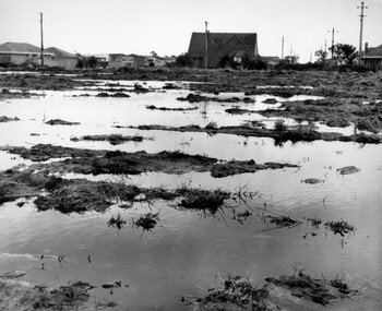
Photograph - Black and white, c. 1958
Unsealed roads and drainage problems created difficulties for those living in Beaumaris during the 1950sBlack and white image depicting the Balcombe Road and Haywood Street, Beaumaris. Unsealed roads and drainage problems have created boggy slushy land. There are houses in the background, indicating people live in the area.Handwritten in red ink on reverse: 90% Handwritten in blue ink on reverse: 2193beaumaris, roads, drainage, water logged, housing -
 Lakes Entrance Historical Society
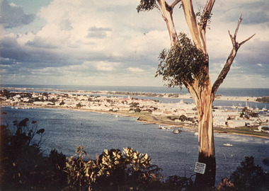
Photograph - Township, 1980
Also two different views of Lakes Entrance from KalimnaColour photograph showing the township situated on the land between the two stretches of water, the North Arm and the Cunninghame Arm. In the background can be seen the sand hummocks and the Southern Ocean. Lakes Entrance Victoria township, waterways -
 National Vietnam Veterans Museum (NVVM)
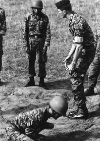
Photograph, Gibbons, Denis, Bearcat, South Vietnam
Denis Gibbons (1937 – 2011) Trained with the Australian Army, before travelling to Vietnam in January 1966, Denis stayed with the 1st Australian Task Force in Nui Dat working as a photographer. For almost five years Gibbons toured with nine Australian infantry battalions, posting compelling war images from within many combat zones before being flown out in late November 1970 after sustaining injuries. The images held within the National Vietnam Veterans Museum make up the Gibbons Collection. A black and white photograph - Bearcat South Vietnam, 1970, a member of Australian Army Ttraining Team Vietnam (AATTV) instructs Vietnamese Ranger recruits in the correct way to land during parachute trainingphotograph, bearcat, aattv, arvn soldier, gibbons collection catalogue, australian army training team vietnam (aattv), vietnamese ranger, parachute training, denis gibbons -
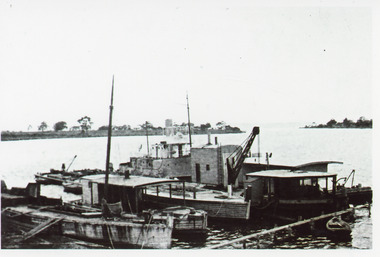 Lakes Entrance Historical Society
Photograph - Paynesville Slipway, 1910 c
Photocopy of photograph has names of all the boats, W H Edgar, suction dredge called Paynesville, grab dredge called Priest Man, stores barge called Lady Harriet, a boat used to keep rivers free of snags called Snagger, sand hopper barge from W H Edgar in process of being dismantled. Information provided by Reg Schulz.Black and white photograph showing five boats / barges at slipway, one with crane. Little row boat in foreground at jetty. Point of land in background, Raymond Island, sparse vegetation. Paynesville Victoriaships and shipping, wharfs -
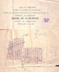 Ringwood and District Historical Society
Map - Plan of Subdivision, Crown Allotments 4 and 5, and Parts of Crown Allotments 6, 8 and 9 Section B, Township and Parish of Ringwood, County of Mornington - Salter's Estate East Ringwood Victoria - 1956
Land Title map of 51 allotments with property dimensions and handwritten real estate sales notations. Copy of map on cardboard backing - extracted from auction advertisement for Saturday, 10th November (1956).Subdivision includes Railway Avenue, Nicholson Street, Althol Grove (later Morcom Avenue), Illoura Avenue, Tweed Street, Merry Street, and Dublin Road, Ringwood East, Victoria. -
 Ringwood and District Historical Society
Map, Plan of Subdivision - State School Estate, Ringwood East, Victoria - (Undated, circa 1920s)
Map of land for sale attached to green cardboard backing with handwritten notations showing numbered allotments on Dublin Road, Holland Road, King Street, Charles Street and Purser Avenue, Ringwood East.Locality plan includes reference to proposed Ringwood East railway station which opened in 1925. -
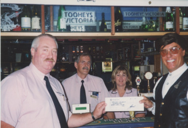 Lakes Entrance Historical Society
Photograph - Lakes Entrance Bowls Club, Lakes Post Newspaper, 2001
Colour photograph Bowls Club Manager Geoff Rhodes presenting cheque to John Couzens, Land Mine Amputees Fundraiser. Bill Aitkens and Jenny Dowie behind the bar. Lakes Entrance Victoriabowls club, donation, fundraising -
 Bayside Gallery - Bayside City Council Art & Heritage Collection
Map, H.B. Foot, Plan of the Brighton Estate containing 5120 acres, first special survey at Port Phillip, c. 1842
This plan records the Brighton Estate, also known as Dendy's Special Survey. In 1840 Henry Dendy, a farmer in Surrey, England acquired a "Special Survey" from the Commissioners for Land and Emigration which gave him the right to choose land in Port Phillip for the low price of £1 per acre for 5120 acres. Dendy appointed Jonathan Binns Were, as his agent, who later became a partner. Together, Dendy and Were decided on an area 5 miles south from Melbourne, bounded by North Road, East Boundary Road, South Road and to the west by Port Phillip Bay. Their Brighton Estate was first surveyed by T. S. Townsend in May 1841 and was re-surveyed by Robert Hoddle. Dendy and Were were making plans to sell the land and advertised a 30-guinea prize for the best subdivision which was to be divided into a village, marine residences, suburban and cultivation allotments, with the remainder being divided into country sections. The competition was won by H.B. Foot, who planned the village around a reserve and crescents and a 'green belt' forming the town boundary. brighton estate, dendy's special survey, special survey, henry dendy, jonathan binns were, w.b. were, survey, plan, map, brighton, george ward cole, baker's lithographer, hibernian, subdivision, town planning, cartographic material, h.b. foot -
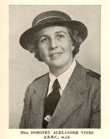 Melbourne Legacy
Article, Melbourne Legacy, Miss Dorothy Vines, 1955
The newsletter from August 1955. It featured photos of the Legacy staff, including Miss Dorrie Vines the Matron of Stanhope. It summarises her life before joining Stanhope on 11 November 1946. She had served with distinction overseas during World War 2 as a Major with the Royal Australian Army Nursing Corps. At the beginning of 1940 she went to the Middle East and served as Senior Sister of No.1 Casualty Clearing Station and shortly afterwards was appointed Sister-in-charge of the No.3 Casualty Clearing Station. She returned to Australian in 1943 and was appointed Matron of a hospital in Alice Springs and in 1944 she again left Australia for New Guinea as Matron of the 2/11 Australian General Hospital. For her war service she was awarded the medal of an Associate of the Royal Red Cross in 1943 and was also mentioned in despatches. Miss Vines remained at Stanhope until her retirement in December 1966.Newsletter outlining news of Junior Legatee activities also occassionally contained information about staff.Black and white printed article about Miss Vines from Newsletter published August 1955. Volume 9 Number 2staff, residences, dorothy vines -
 Bendigo Historical Society Inc.
Photograph - The Wilkin Family of Sedgwick - Isaac and Letitia Barcley, 1800s-1900s
The Phil Wilkin Collection contains a series of 11 Items. The related items can be found by clicking on the reference link below. The following history of the Young family and their descendants who lived at the Springs is provided by Phil Wilkin. His Great Grandparents were Frances Young and August Wirth. Phil has also provided notes on the Wilkin Family and some history of the gold mining in Sedgwick. Frances Young's parents Joseph and Margaret Young owned the property called "The Old Place, Preston Vale or Wellington Flat" at Sedgwick near the Springs. Joseph Young owned and Managed the Standard Brewery which was located at Campbells Creek during the late 1800’s early 1900’s. Joseph and Margaret are buried in the Harcourt cemetery. In 1880 August Wirth lived at Mosquito Creek (Lake Eppalock, Victoria) when he married Frances Young. In 1902 they moved to part of Joseph Young's property. They milked cows and sold cattle for a living. One of their children Charles Wirth (Phil Wilkin's Grandfather) bought the land in 1935 after his parents had died. Charles Wirth was a councillor and also was president of the Shire of Strathfieldsaye. The "Old Place" was part of the property owned by members of the family. The old house at the Springs was burnt out by bushfire in January 1944 and much of the stonework was later vandalized by campers. The original Coliban Water Works were designed in 1863 by the Irish engineer Joseph Brady. The system included 70 kilometres of open water channels, aqueducts, syphons and tunnels to carry water (by gravity) from the Coliban River at Malmsbury, north to Castlemaine and Bendigo. Sedgwick is a locality in Central Victoria, Australia. It is located in the City of Greater Bendigo. Facilities include a public hall that opened in 1958 and CFA Rural fire station. It was named Upper Emu Creek until 1901 when it was renamed as Sedgwick after British geologist Adam Sedgwick.Seven historical documents of Isacc and Letitia Barcley who were associated with the Wilkin Family and also with the Springs near Sedgwick. There are 182 photos in this series and can be found at 8683.1 to 8683.11. The series also includes photos of the surrounding farming land and the remains of an old house. There are also some notes on the pioneers of the district.history, bendigo, coliban water, joseph brady, irrigation, the springs, sedgwick, phil wilkin collection, joeseph and margaret young, letitia and isacc barclay -
 Bendigo Historical Society Inc.
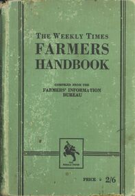
Book - ERROL BOVAIRD COLLECTION: THE WEEKLY TIMES FARMERS HANDBOOK
Book with green cloth cover, black printing, black vertical and horizontal lines, and a black Logo of The Herald Press. It has a man on a rearing horse playing a trumpet. Livestock covered are horses, cattle, pigs, sheep, poultry, dogs, cats and ferrets. Also covered are fruits, vegetables, flowers General Information, Index to Advertisements, Clearing Out Rabbit Warrens, The Horse and Its Harness, Economical Feeding of Livestock and Good Fencing is a Wise Investment.john bovaird collection - the weekly times farmers handbook, farmers' information bureau, the herald press, the herald and weekly times ltd melbourne -
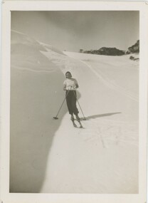 Falls Creek Historical Society
Photograph - Joan Meyer near Fitzgerald's Hut
MEYER COLLECTION - FALLS CREEK PHOTOS In 1947 a determined group of like-minded State Electricity Commission (SEC) staff including Ray Meyer, the chief surveyor of the Kiewa Hydro-Electric Scheme, had a common interest that revolved around the skiing potential of the snow-covered high plains which included what is now the resort of Falls Creek. The six SEC employees, Toni St Elmo, Ray Meyer, Jack Minogue, Lloyd Dunn, Adrian Ruffenacht and Dave Gibson (together with their families) banded together to secretly build a 'hut' that was the first ski lodge at Falls Creek. Using a road built in 1930s to gain access to Falls Creek, their hut project was carried out in secret as efforts by other skiers were blocked by H.H.C. Williams – the engineer in charge of the Hydro Scheme. In 1946 Ray Meyer made a trip to the Lands Office in Melbourne. He came away with a 99-year lease on three acres that was ideally suited for a hut designed by Lloyd Dunn. Adrian Ruffenacht (Design Engineer for the KHS) had suggested where the group should build because of easy access to a spring for water. Much of the building material required was scavenged from derelict huts on the high plains. Due to the need for secrecy, the determined group worked on the hut in the evenings and weekends to avoid detection. During the building period the group had met at Echidna Rock (now known as Eagle Rock) where Skippy St Elmo announced, "This is my favourite ‘Skyline’.” And so the first lodge in the area at Falls Creek Ski Resort came into existence. With the development of the International Poma in the 1970s, the Skyline Lodge, which was sited between the ski-lift’s pole one and pole two, was demolished. However, the legacy of Ray Meyer, Toni St Elmo, Jack Minogue, Lloyd Dunn, Adrian Ruffenacht and Dave Gibson and Skyline lives on in the vibrant atmosphere of Falls Creek Resort. The MEYER COLLECTION documents developments on the Kiewa Hydro Scheme and their life at Falls Creek from the mid 1930s to 1960s.These images are significant because they depict aspects of the life of a pioneering family of Falls Creek and the founders of "Skyline", the first lodge at Falls Creek.Images of Joan Meyer near Fitzgerald's Hut on the Bogong High Plains. The original Fitzgerald Hut was built in 1903 by George Silas Fitzgerald. Destroyed by fire in 1991, it was rebuilt using salvaged and recycled timber. It is located in a large clearing, three to four hours hike from the Bogong High Plains Road These images document Joan's first trip on skis carrying a pack on her back.The trip took about two weeks to complete.falls creek, victorian snowfields, joan meyer, fitzgerald hut -
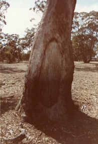 Stawell Historical Society Inc
Photograph, Aboriginal Canoe Trees near Campbells Bridge
Set of five colour photographs of Aboriginal Scar Trees near Campbells Bridge on the Wimmera River. Majority may be of canoes, one may be of a shield cut into the bark.Set of five colour photographs of scar trees. Taken in a bushland setting. First photo is a close up of the scar tree with a shadow over half of the tree. Second photo, same tree with less shadow over tree. Third photo, smaller scar cutting in rough bark tree. Fourth photo, distant view of scar tree with trees in the background. Fifth photo, close up of the distant tree, clearing showing the canoe scar. At Campbell's Bridge on Wimmera River. 1. A309/23 April 2, 1983. 2. A 309/24 April 2, 1983. 3. A 309/20 April 2, 1983. 4. A 309/18 April 2, 1983. 5. A 309/22 April 2, 1983. stawell -
 Bendigo Historical Society Inc.
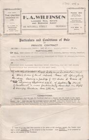
Document - H.A. & S.R. WILKINSON COOLLECTION COLLECTION: CONDITIONS OF SALE
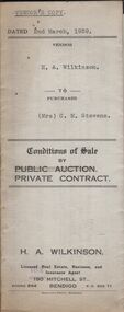
Conditions of sale by private contract dated 2nd March, 1939 between H.A. Wilkinson (seller) and Mrs. C.M. Stevens (buyer) for land situate No. 1 Carolin Street, Bendigo being part of Crown allotment 217 section H being land described in certificate of volume 6129 folio 1225728, together with 4-roomed weatherboard dwelling and all sundry. Also gas stove and all wire window screens. Price 650 pounds. Vendor's copy.organization, business, h.a. & s.r wilkinson real estate -
 Bendigo Historical Society Inc.
Document - H.A. & S.R. WILKINSON COLLECTION: CONTRACT OF SALE
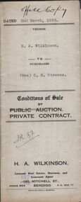
Conditions of sale by private contract dated 2nd March, 1939 between H.A. Wilkinson (seller) and Mrs. C.M. Stevens (buyer) for land situate No. 1 Carolin Street, Bendigo being part of Crown allotment 217 section H being land described in certificate of volume 6129 folio 1225728, together with 4-roomed weatherboard dwelling and all sundry. Also gas stove and all wire window screens. Price 650 pounds. Office copy.organization, business, h.a. & s.r wilkinson real estate -
 Bendigo Historical Society Inc.
Document - H.A. & S.R. WILKINSON COLLECTION: CONTRACT OF SALE
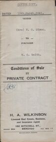
Conditions of sale by private contract dated 13th March, 1941 between Mrs. H.C. Dixon (seller) and W.C. Smith (buyer) for land situate No. 467 Backhaus Street, corner Sheridan Street, Long Gully being land described in right to occupy residence area No. 7368, together with 5-roomed weatherboard and brick dwelling and all sundry. Also ''Liverpool'' gas stove, wire doors and window screens, electric light globes and shades, but no fancy shades. Price 415 pounds.organization, business, h.a. & s.r wilkinson real estate -
 Bendigo Historical Society Inc.
Document - H.A. & S.R. WILKINSON COLLECTION: CONTRACT OF SALE
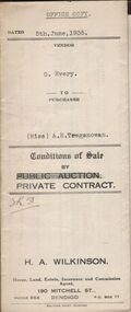
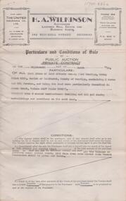
Conditions of sale by private contract issued by H.A. Wilkinson house, land, estate, insurance and commission agent, 190 Mitchell street, Bendigo and dated 5th June 1935between G. Every (seller) and Miss A.E. Treganowan (buyer) for land situate George Street, Bendigo being part of Crown allotment 77 section H described in certificate of title volume 5378 folio 1075507, together with 4-roomed bungalow and all sundry. Price 534 pounds.organization, business, h.a. & s.r wilkinson real estate -
 Bendigo Historical Society Inc.
Document - H.A. & S.R. WILKINSON COLLECTION: CONDITION OF SALE
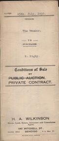
Conditions of sale by private contract dated 15th July, 1930 between H.A. Wilkinson (seller) and R. Rigby (buyer) for land situate Wallan Street, California Gully, being Crown allotment 148 section M described in certificate of title volume 3651 folio 730163, together with 5-roomed weatherboard dwelling and all sundry. Also all vendor's interest in and to the adjoining block of land on the lower side of the above mentioned property. Price 100 pounds.organization, business, h.a. & s.r wilkinson real estate -
 Bendigo Historical Society Inc.
Document - H.A. & S.R. WILKINSON COLLECTION: CONTRACT OF SALE
Conditions of sale by private contract dated 15th July, 1930 between H.A. Wilkinson (seller) and R. Rigby (buyer) for land situate Wallan Street, California Gully, being Crown allotment 148 section M described in certificate of title volume 3651 folio 730163, together with 5-roomed weatherboard dwelling and all sundry. Also all vendor's interest in and to the adjoining block of land on the lower side of the above mentioned property. Price 100 pounds.organization, business, h.a. & s.r wilkinson real estate -
 Bendigo Historical Society Inc.
Document - H.A & S.R. WILKINSON COLLECTION: CONDITION OF SALE
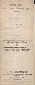
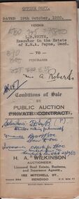
Conditions of sale between private contract issued by H.. Wilkinson and dated 19th October, 1950 between L.B. White, Executor in the estate of K.M.A. Payne (seller) and A. Roberts for land situate No. 18 Hayes Street Bendigo being part of Crown allotment 500A section A Parish of Sandhurst, City and County of Bendigo and being the land remaining in Crown grant volume 6276 folio 1255184, together with 4-roomed weatherboard dwelling and all sundry. Price 835 pounds.organization, business, h.a. & s.r wilkinson real estate -
 Bendigo Historical Society Inc.
Document - MINE SAFETY CAGES & FEDDER DUSTER
Three pages of extracts titled Mine Safety Cages, Old Bendigonians, memories of 'Fedder Duster', a Chinese Market Gardener; and a book review. The Safety Cage was an invention to stop the cage falling down the shaft if the rope gave way. Fedder Duster was a Chinese Market Gardener who was forced off his garden lease. His name was Ah Louey. The Book Review was 'Land, Labour and Gold' or Two Years in Victoria, with visits to Sydney and Van Diemen’s Land, by William Howitt.document, names of bendigo pioneers, mine safety cages & fedder duster, tasmanian foundry, mr j h seymour, dr stewart, conflecua mine malmsbury, thomas dunne, mr frank fitzpatrick, mr a llewellun, old bendigonians, mr john robshaw, mr hugh mcdevitt, alexander bayne, mr f sciallero, camp reserve, art gallery, hon. w i winter-irvine, george avery fletcher, great central goldfield, dear old bendigo 1892, fedder duster, mrs chancellor, ah louey, market gardener, mr curnow, technical school art class, bendigo benevolent home, joch, land labour and gold 1855, two years in victoria with visits to sydney and van diemen's land, william howitt, lowden publishing co, government camp, stars & stripes of america, odd fellows, freemasons, miss f kingerlee -
 Bendigo Historical Society Inc.
Document - H. A. & S. R. WILKINSON COLLECTION: CONTRACT OF SALE
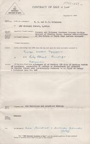
Conditions of sale by public auction dated 18th March, 1950 between T. Pratt (vendor) and W. & M. G. Spedding (purchaser). Property: land situate Grassy Flat, Bendigo being allotment 218B, Parish of Sandhurst County of Bendigo, containing 2 acres and 26.5 perches, land described in Crown grant volume 3127 folio 625277, together with 5 room weatherboard dwelling and all sundry outbuildings. Price: 800 pounds. Attached 1 hand written note.organization, business, h.a. & s.r wilkinson real estate -
 Bendigo Historical Society Inc.
Document - H. A. & S. R. WILKINSON COLLECTION: CONTRACT OF SALE
Conditions of sale by private contract dated 14th August, 1945 between R. D. Bawden (vendor) and Mrs. M. Steel (purchaser). Property: land situate in Grave Street, Spring Gully, having a frontage of 197 links to Grave Street east and adjoining allotment 432E section H, Parish of Sandhurst, land described in right to occupy residence area title No. 7885, together with 4 room Egyptian brick dwelling and all sundry outbuildings. Price: 280 pounds.organization, business, h.a. & s.r wilkinson real estate -
 Bendigo Historical Society Inc.
Document - H. A. & S. R. WILKINSON COLLECTION: CONTRACT OF SALE
Contract of sale of land dated 19th September 1956 between Farmers and Citizens trustees Company Bendigo administrators of the estate of Edith Maud Burrows deceased (vendor) and Mr. G. W. Symons (purchaser). Property: land being allotment 15 section 17B Parish of Sandhurst city of Bendigo, containing 34 perches situated 60 thistle Street referred in right to occupy a residence area no. 006, together with all buildings thereon. Price: 520 pounds.organization, business, h.a. & s.r wilkinson real estate -
 Bendigo Historical Society Inc.
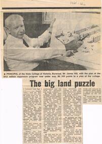
Document - LA TROBE UNIVERSITY BENDIGO COLLECTION: THE BIG LAND PUZZLE10-ACRE MIX UP
A newspaper article titled 'The Big Land Puzzle: 10-acre mix up'. This relates to a difference of opinion over what a 10 acre site was bought for. The Principal of the State College of Victoria, Burwood Mr. James Mac Hill, said it wasn't bought for a college to train teachers for handicapped children as was reported by The Minister for Education Mr. Lindsay Thompson. The Principal said the land was being acquired by the State College of Victoria, campus. The article includes a photo of Mr. Hill. Gazette, 1974.bendigo, education, state college of victoria burwood, la trobe university bendigo collection, collection, bendigo teachers' college, mr. james mac hill, land development, state college of victoria burwood campus, tertiary education, mr. lindsay thompson, minister of education -
 Bendigo Historical Society Inc.
Document - CONNELLY, TATCHELL, DUNLOP COLLECTION: MORTGAGE MR. GEORGE LADSON TO T. LUXTON
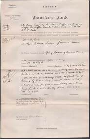
Mortgage document ( 19 August 1892 ) and related correspondence between Mr. George Ladson to Mr. T. Luxton Esq. re purchase of land in Parish of Macorna, County of Gunbower. Includes transfer of land between The Irrigable Estate Coy, to Mr. George Ladson. Letters from Connelly, Tatchell & Dunlop, Thomas Luxton, Irrigable Estate Company, Irrigation & Water supply Trust, George Welch, Railway Hotel, Macorna, draft of document which includes name of John Quick ( unsigned )cottage, miners, george ladson, thomas luxton, john quick, connelly & tatchell, macorna, irrigation and water supply trust, tragowel -
 Kew Historical Society Inc
Photograph - The Boulevard at Kew, 1937
The Yarra Scenic Boulevard stretching from Hawthorn to the Chandler Highway was completed as a major project between 1933 and 1936 during a period of significant unemployment. Key dates in the construction this section the road include: 1933 when Kew Council supported the construction of the road from Studley Park to the Kew Asylum; and 1936 when the road from the Johnston Street Bridge to the Chandler Highway was opened. The inscription on the reverse of the photo 'Boulevard Fairfield' is misleading as there is no section of the Boulevard in Fairfield. A more likely interpretation is that it is a photograph of the Kew section of the Yarra Boulevard with the factories of Fairfield in the distance.Rare early photograph of the Yarra Boulevard, taken one year after the opening of the road. The photograph is an important historical record of the results of 'Susso' labor in the creation of major works in Melbourne by the Victorian Government. Original, black and white positive print of the Boulevard at Kew in 1937. Key aspects to note about the photograph is that the road is bituminised; that the gutters are concreted; that the kerb is constructed of concrete blocks; and that there is an unmade footpath on what appears to be the right hand side of the road. The landscape is sparsely treed, and those trees that remain are presumably remnant vegetation. At the right, the land is fenced. The land at the left falls away sharply to the river below. On the horizon, at left, there is an industrial complex including a tall chimney that is burning fuel creating smoke. "Boulevard Fairfield" great depression, susso projects, roads -- kew (vic.), yarra boulevard, yarra valley -
 Bendigo Historical Society Inc.
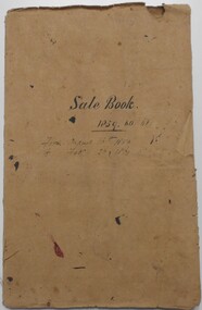
Document - LANDS OFFICE: SANDHURST AND DISTRICT LAND SALES BY PUBLIC AUCTION 1859 - 60
Document: booklet, brown heavy paper cover bound secured with white cotton. Blue paper pages. On front cover ' Sale Book 1859, 60, 61. From August 16th. 1859 to Feb. 26 1861' Contains newspaper cuttings of crown land sales held in Sandhurst. Alongside cuttings are columns: price per acre, amount, purchasers. White sticker fixed to pocket: Book 7 Sandhurst Land Sales 16 August 1859 to March 1861Lands Officebendigo, land sales 1859 - 60, lands office, sandhurst, crown land, auctions