Showing 2646 items matching "lots"
-
 Whitehorse Historical Society Inc.
Document, Notice of default in rate payments, 1933, 1937
A notice of default in rate payments to Shire of Blackburn and Mitcham to the Freehold Investment and Banking Co of Australia LtdA notice of default in rate payments to Shire of Blackburn and Mitcham to the Freehold Investment and Banking Co of Australia Ltd and a solicitor's letter requesting more information about the sale of land to T.J. Kiker.A notice of default in rate payments to Shire of Blackburn and Mitcham to the Freehold Investment and Banking Co of Australia Ltdmetropolitan avenue, nunawading, lot 2, shire of blackburn and mitcham, kiker, t.j., freehold investment and banking company of australia ltd, rates -
 Whitehorse Historical Society Inc.
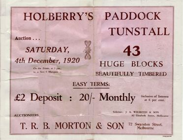
Pamphlet, Holberry's Paddock Tunstall, 1920
Article on development of 30 lot subdivision of former Blackburn East Primary School SiteAuction of Holberry's Paddock, Tunstall - 43 blocks, 4 December 1920. Includes plan.Article on development of 30 lot subdivision of former Blackburn East Primary School Siteshady grove, nunawading, mount pleasant road, holberry street, t. r. b. morton & son, auctions, forest hill holberrys paddock, tunstall -
 Whitehorse Historical Society Inc.
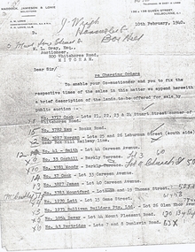
Document, Land Sales
Letter from A. M. Lonie of Maddock, Jameson & Lonie, solicitors to M.L. Grey Esq , Auctioneer,Letter from A. M. Lonie of Maddock, Jameson & Lonie, solicitors to M.L. Grey Esq , Auctioneer, 800 Whitehorse Rd, Mitcham regarding charging orders for land sales.Letter from A. M. Lonie of Maddock, Jameson & Lonie, solicitors to M.L. Grey Esq , Auctioneer,cock, stuart street, blackburn, whitehorse road, mau, rooks road, mitcham, morgan, laburnum street, lots 25, 26, smith, carween avenue, lot 44, coghill, barkly terrace, lot 3, moody, church street, lot 4, cook, lot 33, james, lot 40, mountford, thomas street, lot 19, lett, game street, lot 15, sullivan builders pty ltd, glen ebor avenue, lot 26, davey, mount pleasant road, forest hill, partridge, dunlavin road, lots 7 & 8, wright, mcdowall street, lots 106 - 7, gibb, lot 9 -
Whitehorse Historical Society Inc.
Document, Certificate of Title Lot 14 May Court Mitcham, 1/03/1962 12:00:00 AM
Copy of Certificate of Title and subdivision plan of May Court, and Irene Crescent, Mitcham,Copy of Certificate of Title and subdivision plan of May Court, and Irene Crescent, Mitcham, purchased from Louis Ernest Schwerkolt by Robert Charles Gardiner and Barbara June Gardiner in 1962.Copy of Certificate of Title and subdivision plan of May Court, and Irene Crescent, Mitcham,schwerkolt, louis ernest, gardiner, bob, gardiner, barbara, certificates, land titles -
 Ballarat Heritage Services
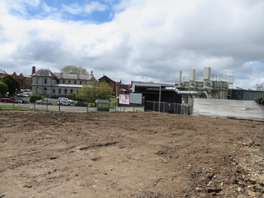
Photograph - Colour, Vacant Lot on the Corner of Armstrong Street South and Grant Street, Ballarat, 2017, 15/09/2017
Colour photograph of a vacant block. It had formerly been Leading Edge Computer which burnt down in 2016. The building was leveled in September 2017.armstrong street south, vacant black, grant street -
 Ballarat Heritage Services
Photograph - Colour, Vacant Lot on the Corner of Armstrong Street South and Grant Street, Ballarat, 2017, 15/09/2017
Colour photograph of a vacant block. It had formerly been Leading Edge Computer which burnt down in 2016. The building was leveled in September 2017.armstrong street south, ballarat -
 Ballarat Heritage Services
Photograph - Colour, Vacant Lot on the Corner of Armstrong Street South and Grant Street, Ballarat, 2017, 15/09/2017
Colour photograph of a vacant block. It had formerly been Leading Edge Computer which burnt down in 2016. The building was leveled in September 2017.lamp, anderson and ritchie -
 Ballarat Heritage Services
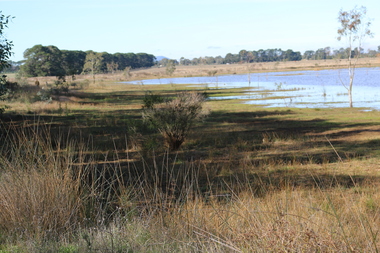
Photograph - Digital photograph, Dorothy Wickham, Winter's Swamp, Ballarat, January to April 2014
Study of Winter's Swamp commissioned by BEN and completed by BHS. The swamp was named after one of the first European settlers in the district. Winter Swamp LAT -37 32 LONG 143 47, Parish of Dowling Forest, County of Grenville Winter Swamp, on the southwest corner of Ballarat West Town Common, was not included in the original proclamation of the Common in 1861. However, being marshland, it was not considered suitable for grazing, so was added to the Common soon after 1861. Winter Swamp is a large wetland with native and exotic pasture significant for wildlife. John Winter (Jock) was born in Berwickshire, Scotland. He married Janet Margaret Irving the daughter of Robert Irving, advocate, Bonshaw, Dumfries, Scotland. Winter died in Ballarat in 1875 and was buried at the Ballaarat Old Cemetery. He took up the run Bonshaw from 1841; Leigh River Buninyong 1842-46; Junction, Delatite, March 1851 to September 1862; with sons: Carag Carag and Corop, April 1857 to September 1872; Colbinabbin and Stewart’s Plains, April 1857 to December 1872; St Germains February 1867 to March 1871. (The name became Winter-Irving in 1890). Mr John Winter, who died on August 22 at the age of 72, was a man of some note it the mining community of Ballarat. He was a self-made man, and one of our oldest colonists, it being over a quarter of a century age since he took up county about Ballarat and settled at Bonshaw. He died very rich. It is calculated that if he had retained an interest in all his runs, his income must have been not less than £10,000 or £50,000 a year. Some eight or ten years ago he sold his Bonshaw pre-emption to the Bonshaw Gold mining Company for £20,000, and a few years later the ground belonging now to Winter's Freehold Company brought him £50,000 more, the payment being made at the requisition of the deceased in sovereigns. In these relations Mr. Winter has been closely identified with the mining industry at Ballarat. The deceased was a native of Lauder, in Berwickshire, and landed in Victoria several years before the gold discovery.The principle task of this project was the delivery of a report outlining the history of European settlement in the Skipton and Cardigan/Ballarat districts as pertinent to the use of and impact on the natural environment of the two reserves Skipton Common and Winter Swamp. The report was delivered in digital form only. The report, upon completion, was presented to the Network’s Committee in order to discuss the project. The report identified and described the uses of Skipton Common and Winter Swamp, and their impacts. In particular, this report examined farming/grazing (official and informal), mining, vegetation removal (including the removal of woodlands for timber, grasslands for pasture improvement) & use of riparian areas for access to water and timber removal. Recording the more benign and environmentally friendly uses such as picnicking, community activities, nature walks and the roles of organisations such as Field Naturalists’ and Bird Observers’ clubs, school and scout/guide groups will be relevant in helping to depict overall community attitudes towards the reserves; e.g.: has the Common generally been viewed as little more than a grazing paddock and fire hazard; has Winter Swamp always been the unknown natural asset that seems to have been its lot for at least the past 40 years? In this regard, the more contemporary history of actions surrounding the use and management of the reserves is of particular interest, in view of the extant evidence at both reserves; e.g. the actions of the Shire of Ballarat in the 1980s in establishing Winter Swamp as something of a competitor to Lake Wendouree but with a more environmental bent (although almost none of the plants used are indigenous species, but that is part of the story); the trotting track constructed on Skipton Common in the 1960s following representations to Premier Henry Bolte and the cropping of the western section of the Common to raise funds for the town’s new swimming pool, the fertilizing of the land putting an end to the native grassland vegetation. There are obviously multiple sources of information to source in preparing the report, however sources that the contractor is specifically requested to consult are the Skipton Historical Society, the former Skipton Common managers (specifically Graeme Pett), the Cardigan Windermere Landcare Group and the Learmonth Historical Society (believed to hold many of the former Shire of Ballarat’s records pertaining to the Council’s role as the Committee of Management for both Winter Swamp and the Ballarat West Town Common – Winter Swamp was split between 2 separate Crown Land tenures). The contractor is also encouraged but not required to utilise community newsletters, such as the Skipton Community Newsletter, to publicise and seek information about the project. Skipton Historical Society (Mary Bradshaw) contacted on Thursday 12 June 2.30pm. Mary lived on a farm out of Skipton but is currently living in the township. She remembers walking along the creek of the Common especially in spring and autumn in bare feet and that it was a very pretty place. There were a few snakes around the waterway in summer. People put cows and a couple of horses on the commonage to graze. Graeme Pett has always lived close to the Common and would know a lot about it. Other possible contacts would be Nicole Petress, Secretary of the Progress Association, and the Corangamite Council, Camperdown. Digital images of Winter's Swampwinter's swamp, ballarat, john winter, ballarat environmental network, mullawullah -
 Ballarat Heritage Services
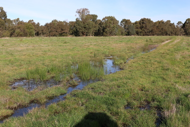
Photograph - Digital photograph, Winter's Swamp surrounds, April 2014
The swamp was named after John (Jock) Winter. John Winter (Jock) was born in Berwickshire, Scotland. He married Janet Margaret Irving the daughter of Robert Irving, advocate, Bonshaw, Dumfries, Scotland. Winter died in Ballarat in 1875 and was buried at the Ballaarat Old Cemetery. He took up the run Bonshaw from 1841; Leigh River Buninyong 1842-46; Junction, Delatite, March 1851 to September 1862; with sons: Carag Carag and Corop, April 1857 to September 1872; Colbinabbin and Stewart’s Plains, April 1857 to December 1872; St Germains February 1867 to March 1871. (The name became Winter-Irving in 1890). Mr John Winter, who died on August 22 at the age of 72, was a man of some note it the mining community of Ballarat. He was a self-made man, and one of our oldest colonists, it being over a quarter of a century age since he took up county about Ballarat and settled at Bonshaw. He died very rich. It is calculated that if he had retained an interest in all his runs, his income must have been not less than £10,000 or £50,000 a year. Some eight or ten years ago he sold his Bonshaw pre-emption to the Bonshaw Gold mining Company for £20,000, and a few years later the ground belonging now to Winter's Freehold Company brought him £50,000 more, the payment being made at the requisition of the deceased in sovereigns. In these relations Mr. Winter has been closely identified with the mining industry at Ballarat. The deceased was a native of Lauder, in Berwickshire, and landed in Victoria several years before the gold discovery. BHS were commissioned by Ballarat Environment Network for a project on Winter's Swamp and Skipton Common. Winter's Swamp was part of Ballarat West Common. The principle task of this project was the delivery of a report outlining the history of European settlement in the Skipton and Cardigan/Ballarat districts as pertinent to the use of and impact on the natural environment of the two reserves Skipton Common and Winter Swamp. The report was delivered in digital form only. The report, upon completion, was presented to the Network’s Committee in order to discuss the project. The report identified and described the uses of Skipton Common and Winter Swamp, and their impacts. In particular, this report examined farming/grazing (official and informal), mining, vegetation removal (including the removal of woodlands for timber, grasslands for pasture improvement) & use of riparian areas for access to water and timber removal. Recording the more benign and environmentally friendly uses such as picnicking, community activities, nature walks and the roles of organisations such as Field Naturalists’ and Bird Observers’ clubs, school and scout/guide groups will be relevant in helping to depict overall community attitudes towards the reserves; e.g.: has the Common generally been viewed as little more than a grazing paddock and fire hazard; has Winter Swamp always been the unknown natural asset that seems to have been its lot for at least the past 40 years? In this regard, the more contemporary history of actions surrounding the use and management of the reserves is of particular interest, in view of the extant evidence at both reserves; e.g. the actions of the Shire of Ballarat in the 1980s in establishing Winter Swamp as something of a competitor to Lake Wendouree but with a more environmental bent (although almost none of the plants used are indigenous species, but that is part of the story); the trotting track constructed on Skipton Common in the 1960s following representations to Premier Henry Bolte and the cropping of the western section of the Common to raise funds for the town’s new swimming pool, the fertilizing of the land putting an end to the native grassland vegetation. There are obviously multiple sources of information to source in preparing the report, however sources that the contractor is specifically requested to consult are the Skipton Historical Society, the former Skipton Common managers (specifically Graeme Pett), the Cardigan Windermere Landcare Group and the Learmonth Historical Society (believed to hold many of the former Shire of Ballarat’s records pertaining to the Council’s role as the Committee of Management for both Winter Swamp and the Ballarat West Town Common – Winter Swamp was split between 2 separate Crown Land tenures). The contractor is also encouraged but not required to utilise community newsletters, such as the Skipton Community Newsletter, to publicise and seek information about the project. Skipton Historical Society (Mary Bradshaw) contacted on Thursday 12 June 2.30pm. Mary lived on a farm out of Skipton but is currently living in the township. She remembers walking along the creek of the Common especially in spring and autumn in bare feet and that it was a very pretty place. There were a few snakes around the waterway in summer. People put cows and a couple of horses on the commonage to graze. Graeme Pett has always lived close to the Common and would know a lot about it. Other possible contacts would be Nicole Petress, Secretary of the Progress Association, and the Corangamite Council, Camperdown. Mary can’t remember any photos in the Skipton Historical Society that pertain to the Common. Digital photos of Winter's swamp surrounds, later known as Mullawullah.winter, winter's swamp surrounds, winter's swap, john winter, ballarat environmental network, ballarat, mullawullah -
 City of Ballarat Libraries
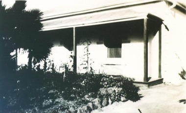
Photograph, 23 Raglan Street Lot 29 circa 1910
23 Raglan Street was built in 1855.raglan street, ballarat, house, housing -
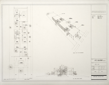 RMIT Design Archives
Architectural drawings, Proposed Family Residence for Mr. & Mrs. Spedding at Lot 2 Bolton Avenue, Brighton
Sketh plansink, acetate -
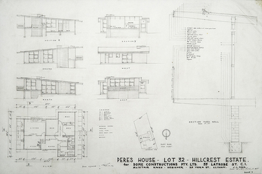 RMIT Design Archives
Architectural drawings, Sample House, Lot 36, Hillcrest Estate
Designed for Dome Contructions Pty. Ltd.ink, acetate -
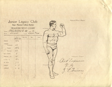 Melbourne Legacy
Document, Medical Officers Report, 1927
A chart for taking measurements of the Legacy boys. This was a copy of the form that was kept as an example. The data was of measurements of junior legatee W. Gallagher. The form was signed J. Teirney, which was Jim Teirney who was the first paid employee of Melbourne Legacy, he was the fitness instructor for many years. The date was 1927 so very early in the history of Legacy working with children of deceased servicemen. Shows Legacy was active in record keeping with proper medical supervision for physical activities of the children, in 1927.The method of record keeping was all done by hand, time consuming and the storage of records took up a lot of space.Diagram of a measurement chart with sketch of a male body. Printed in black and white.Medical Officers Report. Junior Legacy Club. Name: Gallagher. W., age 10, Group Junior, section Lone Pine. Measurements of the neck, chest, thigh, calf, arm, height and weight. Signed by J.E. Tierneyjunior legatee, exercise classes -
 Melbourne Legacy
Letter, re. Captain Frank and Mrs Frank
Letter from Captain Bert Frank of 24 York St, St Kilda, applying for the manager position at the first Legacy Hostel, named Holmbush. It outlines his war service in WWI (with the 1st and 2nd A.I.F), civilian career running a Ford garage for 20 years and his interests. Also the education and experience of his wife, Clare Frank, and mentions their 10 year old son. It provides referees for both of them. Holmbush was the first hostel for children that Legacy started and operated from April 1943. It was later renamed Blamey House after another hostel called Blamey House was closed. Melbourne Legacy ran three residences: Blamey House (purchased 1947) , Stanhope (purchased 1945) and Harelands (purchased 1950), to take care of children whose fathers were servicemen, and who may have been left orphans, or whose mother may have been unable to care for them herself. Harelands accommodated boys and girls under the age of 14, Blamey House looked after boys over 14, and Stanhope looked after girls over 14. The children were cared for until they were old enough to become independent.Capt Frank was the successful applicant for the position and this letter provides a lot of background of his life.White note paper, lined, black ink handwriting, two hole punched.residences, holmbush, staff, bert frank -
Moorabbin Air Museum
Document (Item) - Hard backed folders (4) containing a myriad of photocopied items covering a multitude of aircraft - needs a lot of sorting and classifying
-
 Ballarat Tramway Museum
Photograph - Black & White Photograph/s, 1887/8
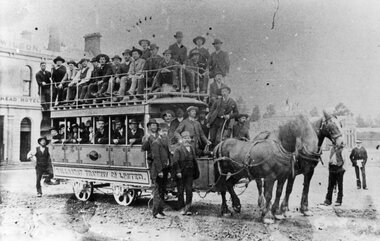
Yields information about the early use of the Ballarat horse trams and condition of the roadway - lots of rocks on the road surface. Also shows an all male loading of passengers.Black and White copy photograph of a State Library of South Australia SLSA B34585 of an well loaded, only male passengers on a Ballaarat Horse Tram - Grenville and Sturt St. Two horse with many men, Wilson's Bucks Head Hotel in background. Condition of the road surface very rough - can't see the rails. Photo taken in early days, as no modesty boards on upper deck - say 1887. Possibly a trial trip. Collected by Alan Bradley from the State Library of South Australia early 1980's. Used in The Golden City and its Tramways - page 28.tramways, trams, sturt st, grenville st, bucks head hotel, horse tram -
 Ballarat Tramway Museum
Photograph - Colour Photograph/s, c1971
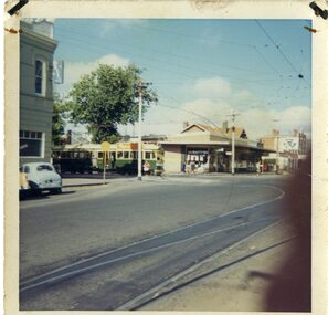
Demonstrates aspects of the Ballarat Tramways operations at this intersection - Hospital Corner - unusual photograph angle - early morning photo - not a lot taken at this time, but of lower photographic quality.Colour photograph of a bogie tram in Drummond St south about to cross Sturt St - c1971, taken from the median strip early in the morning. Has the Southern Cross Hotel on the left hand side of the photograph and the liquor store in the background.sturt st, drummond st -
 Ballarat Tramway Museum
Document - Photocopy, Alan Bradley, "Be Independent of Trams, Trains and Buses", 2003
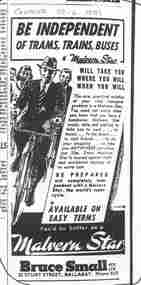
Yields information how local shops reacted to proposed fare increases, by advertising alternative forms of transport - bicycles. Also yields information about Bruce Small and his cycle shops. Bruce Small became Mayor of the Gold Coast and was responsible for a lot of its development in the 1970's.Photocopy, of an advertisement in The Courier, 22/6/1951, at the time of the proposed SEC Tram fare rises, titled "Be Independent of Trams, Trains and Buses". Advertises Malvern Star bicycles, for Bruce Small Pty Ltd, gives address and telephone number. Bruce Small well known retailer of bicycles at the time, went on to become the Mayor the Gold Coast region.trams, tramways, public transport, fares, sec, malvern star bicycles -
Moorabbin Air Museum
Manual (Item) - Includes lots of good diagrams and detail, B-17F airplane. Erection and Maintenance instructions
-
Moorabbin Air Museum
Manual (Item) - A.A.P 5135.002 RAAF Lots of pomp and circumstance stuff, Manual of ceremonial
-
 Ballarat Tramway Museum
Photograph - Lots of handshakes on the last day of SECV Ballarat Trams - 19-9-1971
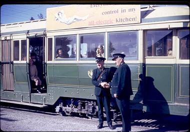
This photo shows the crew posing beside the tram for the photographers at the Lydiard St North terminus. There is a crowd of people, in the tram. The photographer says this was taken of the last of the last tram to run in Lydiard Street in 1971.Demonstrates that on the last day, the crews posed for many photographsDigital image of Copy of a colour slide showing Tram 42 at the Lydiard Street North terminus. ballarat trams, •last day, •lydiard st nth, •secv tramways, •tramway closure, •maximum traction, crews -
 Kew Historical Society Inc
Photograph - 'Mount Eri', 9 Highbury Grove, 1919
Subdivision plans are historically important documents used as evidence of the growth of suburbs in Australia. They frequently provide information about when the land was sold on which a built structure was subsequently constructed as well as evidence relating to surveyors and real estate and financial agents. The numerous subdivision plans in the Kew Historical Society's collection represent working documents, ranging from the initial sketches made in planning a subdivision to printed plans on which auctioneers or agents listed the prices for which individual lots were sold. In a number of cases, the reverse of a subdivision plan in the collection includes a photograph of a house that was also for sale by the agent. These photographs provide significant heritage information relating house design and decoration, fencing and household gardens.A photograph of Mount Eri, 9 Highbury Grove, an 11-room house for sale near the junction of Cotham and Glenferrie Roads. The substantial red brick, slate-roofed house and its location are not identified in the photograph, although the extent of the house is noted. It was described then as ‘well situated’ and close to 3 trams. Mathers, a financial agent in Cotham Road, placed advertisements about the sale of the property in The Argus in May and June 1919. The advertisement additionally refers to a billiard room and asserts that the house has every modern convenience. An annotation on the plan indicates that the house, with tennis court, was sold for £1960. Following extensive research, the house has now been conclusively identified, albeit extended and rendered. The house was originally built in the 19th century as a school and for much of the 20th century was used as a venue for receptions. -
 Kew Historical Society Inc
Photograph - W.B. Villa, Kew, c.1919
The photograph offers significant information relating to late Victorian / Federation colour schemes and fencing.The block fronted villa has a corrugated iron roof and a flat projecting verandah, ornamented with a trellis design of timber. The front window features a timber shade, mounted on brackets. The treatment of the block-fronted panels shows that there is an attempt to highlight imitation quoining through use of a darker colour. The windows and door are also in this darker shade. The front fence and gate are made of wooden pickets. It is unlikely that the photograph was taken at the time of the villa's construction given the size of the shrub/tree in the front garden.Subdivision plans are historically important documents used as evidence of the growth of suburbs in Australia. They frequently provide information about when the land was sold on which a built structure was subsequently constructed as well as evidence relating to surveyors and real estate and financial agents. The numerous subdivision plans in the Kew Historical Society's collection represent working documents, ranging from the initial sketches made in planning a subdivision to printed plans on which auctioneers or agents listed the prices for which individual lots were sold. In a number of cases, the reverse of a subdivision plan in the collection includes a photograph of a house that was also for sale by the agent. These photographs provide significant heritage information relating house design and decoration, fencing and household gardens.A real estate photograph, mounted on brown card, showing a double fronted weatherboard villa, located in Kew, Victoria. On the reverse of the photograph is a subdivision plan for the Altyre Estate.Stamped on mount: Top - "KEW. Close tram. Fine View. / W.B. Villa Containing 8 Rooms. / Up-to-date Conveniences. EL Etc." Below - "Land 40 x 165. 615 pounds. Sold"houses - kew, real estate photographs -
 Kew Historical Society Inc
Photograph - Brick and Stucco Bungalow, J E Barnes, c.1920
The Kew Historical Society's map collection includes a substantial number of real estate subdivision plans, mainly of Kew but also of surrounding suburbs in Melbourne. Most of the subdivision plans date from the 1920s and 1930s when the districts old homes and local farmland were being split up to accommodate residential growth in the postwar period. These early plans were assembled by a local firm, Jas R Mather & McMillan, which had an office in Cotham Road. Many of the plans, and sometimes photos, were annotated by the agents.Subdivision plans are historically important documents used as evidence for the growth of suburbs in Australia. They frequently provide information about when the land was sold as well as evidence relating to surveyors and real estate and financial agents. The numerous subdivision plans in the Kew Historical Society's collection represent working documents, ranging from the initial sketches made in planning a subdivision to printed plans on which auctioneers or agents listed the prices for which individual lots were sold. In a number of cases, the reverse of a subdivision plan in the collection includes a photograph of a house that was also for sale by the agent. These photographs provide significant heritage information relating house design and decoration, fencing and household gardens.The photograph may also be aesthetically significant depending o the importance of the photographic atelier.Real estate photograph for a local agent by the Kew photographer, Josiah Earl Barnes. The photo is of a weatherboard or brick rendered bungalow with a twisted wire fence. Given Barnes' status a a Kew photographer, the house is probably locate din Kew or East Kew. Unfortunately the handwritten information on the mount bordering the photo is damaged and cannot be read. The bungalow has a gabled, tiled roof with terra cotta finials at the front of both gables. The house has a central doorway, framed by a pseudo portico supported by four wooden columns. On each side of the doorway, at the front, there are paired sash windows, which, like the half-timbered gable, are picked out in a darker colour.Handwritten, mostly illegible description by selling agent on mount surround: " .... in Diningroom, Drawing Rooms, ... Photographers details printed on mount: "J. E. Barnes / Photo / Phone 1966 Haw KEW"houses - kew, bungalows - kew, real estate photographs, j.e. barnes -- photographer -
 Kew Historical Society Inc
Photograph - Victorian Double-fronted Brock Villa, Cotham Road, c. 1919
The Kew Historical Society's map collection includes a substantial number of real estate subdivision plans, mainly of Kew but also of surrounding suburbs in Melbourne. Most of the subdivision plans date from the 1920s and 1930s when the districts old homes and local farmland were being split up to accommodate residential growth in the postwar period. These early plans were assembled by a local firm, Jas R Mather & McMillan, which had an office in Cotham Road. Many of the plans, and sometimes photos, were annotated by the agents.Subdivision plans are historically important documents used as evidence for the growth of suburbs in Australia. They frequently provide information about when the land was sold as well as evidence relating to surveyors and real estate and financial agents. The numerous subdivision plans in the Kew Historical Society's collection represent working documents, ranging from the initial sketches made in planning a subdivision to printed plans on which auctioneers or agents listed the prices for which individual lots were sold. In a number of cases, the reverse of a subdivision plan in the collection includes a photograph of a house that was also for sale by the agent. These photographs provide significant heritage information relating house design and decoration, fencing and household gardens.The photograph may also be aesthetically significant depending o the importance of the photographic atelier.Real estate photographs of a classic double-fronted late Victorian brick villa. It central location in Cotham Road, Kew enabled the selling agent to note its proximity to the tram. With seven rooms, all ‘modern conveniences’, and land of 66×167, the house was to be sold for £1100. The villa has a number of interesting features including a pattern within the slate roof as well as the use of polychrome brickwork under the eaves and on the façade. The intricacy of the cast iron lace is emphasised by the line of projecting wooden blocks above it. The picket gate is painted a different colour to the pickets of the fence. The house has a name (illegible) that is attached to the inset cast iron lace of the central projecting gable in the veranda. Stamped on mount: "Kew. Central. Close tram. / Comfortable Brick Villa. / Containing 7 rooms / Modern conveniences: / Land 66 x 167. Sold 1100 pounds:"houses - kew, victorian villas, real estate photographs, cotham road - kew -
 Kew Historical Society Inc
Photograph - Double-fronted Edwardian Villa, c.1918
The Kew Historical Society's map collection includes a substantial number of real estate subdivision plans, mainly of Kew but also of surrounding suburbs in Melbourne. Most of the subdivision plans date from the 1920s and 1930s when the districts old homes and local farmland were being split up to accommodate residential growth in the postwar period. These early plans were assembled by a local firm, Jas R Mather & McMillan, which had an office in Cotham Road. Many of the plans, and sometimes photos, were annotated by the agents.Subdivision plans are historically important documents used as evidence for the growth of suburbs in Australia. They frequently provide information about when the land was sold as well as evidence relating to surveyors and real estate and financial agents. The numerous subdivision plans in the Kew Historical Society's collection represent working documents, ranging from the initial sketches made in planning a subdivision to printed plans on which auctioneers or agents listed the prices for which individual lots were sold. In a number of cases, the reverse of a subdivision plan in the collection includes a photograph of a house that was also for sale by the agent. These photographs provide significant heritage information relating house design and decoration, fencing and household gardens.The photograph may also be aesthetically significant depending on the importance of the photographic atelier.On the reverse of a subdivision plan of the Palmyra Estate (Kew) is a photograph of a double-fronted Edwardian villa. The weatherboard and stucco house with high brick chimneys provides a clear indication of the style of curtains and gardens in houses of the period. Holland blinds with lace inserts are used in the left front window. They are combined with long lace curtains. The garden, with its curved pathway is bordered with garden beds that include marguerite daisies and roses. Reflecting a new interest in the Australian landscape, tree ferns and ground ferns are planted closer to the house.houses - kew, architecture - edwardian, real estate photographs -
 Kew Historical Society Inc
Photograph - Cottage, probably East Kew, A. Aberline, 1920s
The Kew Historical Society's map collection includes a substantial number of real estate subdivision plans, mainly of Kew but also of surrounding suburbs in Melbourne. Most of the subdivision plans date from the 1920s and 1930s when the districts old homes and local farmland were being split up to accommodate residential growth in the postwar period. These early plans were assembled by a local firm, Jas R Mather & McMillan, which had an office in Cotham Road. Many of the plans, and sometimes photos, were annotated by the agents.Subdivision plans are historically important documents used as evidence for the growth of suburbs in Australia. They frequently provide information about when the land was sold as well as evidence relating to surveyors and real estate and financial agents. The numerous subdivision plans in the Kew Historical Society's collection represent working documents, ranging from the initial sketches made in planning a subdivision to printed plans on which auctioneers or agents listed the prices for which individual lots were sold. In a number of cases, the reverse of a subdivision plan in the collection includes a photograph of a house that was also for sale by the agent. These photographs provide significant heritage information relating house design and decoration, fencing and household gardens.The photograph may also be aesthetically significant depending on the importance of the photographic atelier.An elevated, modest weatherboard house, photographed towards the end of the construction phase. The lower section of the weatherboards are exposed and stained. The upper section is rendered with rough-cast. The tiled roof has a single gable that extends over the centrally placed front porch. On the porch, the door and single sidelight are filled with coloured leadlight whereas the casement windows in the front rooms contain plain glass. The leadlight and the wrought iron of the verandah are the only decorative elements of the utilitarian design. The location of the house, which was advertised for sale, has not to date been identified. The real estate photograph is mounted on the reverse of a subdivision plan for the Harvest Home Estate, Kew East.Photographer's stamp, lower right on mount: "A. Aberline, Glenferrie"houses - kew, bungalows - kew, real estate photographs -
 Kew Historical Society Inc
Photograph - Bungalow, probably East Kew, 1920s
The Kew Historical Society's map collection includes a substantial number of real estate subdivision plans, mainly of Kew but also of surrounding suburbs in Melbourne. Most of the subdivision plans date from the 1920s and 1930s when the districts old homes and local farmland were being split up to accommodate residential growth in the postwar period. These early plans were assembled by a local firm, Jas R Mather & McMillan, which had an office in Cotham Road. Many of the plans, and sometimes photos, were annotated by the agents.Subdivision plans are historically important documents used as evidence for the growth of suburbs in Australia. They frequently provide information about when the land was sold as well as evidence relating to surveyors and real estate and financial agents. The numerous subdivision plans in the Kew Historical Society's collection represent working documents, ranging from the initial sketches made in planning a subdivision to printed plans on which auctioneers or agents listed the prices for which individual lots were sold. In a number of cases, the reverse of a subdivision plan in the collection includes a photograph of a house that was also for sale by the agent. These photographs provide significant heritage information relating house design and decoration, fencing and household gardens.The photograph may also be aesthetically significant depending on the importance of the photographic atelier.An unusual bungalow that does not conform to a particular architectural style but which contains eclectic elements of the style of varying periods. The most striking element of the design is the cantilevered veranda that is supported by heavy chains that are attached to the central gable. This deep gable extends across most of the façade, forming an extensive veranda. Parts of this are infilled with screens. Seven wooden posts, whose lower halves are encased in rendered brick pillars, support this gabled veranda. The roof would appear to be covered with corrugated iron. The location of the house, which was advertised for sale, has to date not been identified. The real estate photo is on the reverse of a plan for the Myrtle Hill Subdivision, Kew.bungalows - kew, architecture - 1920s, real estate photographs -
 Kew Historical Society Inc
Plan - Subdivision Plan, J R Mathers & McMillan, Myrtle Hill Estate, East Kew, circa 1949, c.1949
The Kew Historical Society's map collection includes a substantial number of real estate subdivision plans, mainly of Kew but also of surrounding suburbs in Melbourne. Most of the subdivision plans date from the 1920s and 1930s when the districts old homes and local farmland were being split up to accommodate residential growth in the postwar period. These early plans were assembled by a local firm, Jas R Mather & McMillan, which had an office in Cotham Road. Many of the plans, and sometimes photos, were annotated by the agents.Subdivision plans are historically important documents used as evidence for the growth of suburbs in Australia. They frequently provide information about when the land was sold as well as evidence relating to surveyors and real estate and financial agents. The numerous subdivision plans in the Kew Historical Society's collection represent working documents, ranging from the initial sketches made in planning a subdivision to printed plans on which auctioneers or agents listed the prices for which individual lots were sold. In a number of cases, the reverse of a subdivision plan in the collection includes a photograph of a house that was also for sale by the agent. These photographs provide significant heritage information relating house design and decoration, fencing and household gardens.The photograph may also be aesthetically significant depending on the importance of the photographic atelier.Myrtle Hill, at 14 Vista Avenue, Kew, is of local historical and architectural significance as a good example of a large and imposing single-storey Italianate house of the early 1870s surviving in Kew. Originally sited on a large allotment overlooking Normanby Road, the setting of the house has been dramatically altered through extensive subdivision and development. The subdivision plan of the ‘Myrtle Hill Estate’ indicates that in one such subdivision, 11 allotments were created fronting Bowyer Avenue, Myrtle Avenue, and Normanby Road. The outline and building profile of Myrtle Hill is shown on the west side of Bowyer Avenue.The full (typed) title of this subdivision plan is :"Plan of SUBDIVISION of part of CROWN PORTION 83. / at KEW / PARISH OF BOROONDARA. / COUNTY OF BOURKE". / "MYRTLE HILL ESTATE / EAST KEW" In addition to the Title and subtitle, the plan also lists the advantages of the subdivision. -
 Kew Historical Society Inc
Plan, J R Mathers & McMillan, Sackville, Thomas & Lytton Streets, Kew, Twentieth Century
The Kew Historical Society's map collection includes a substantial number of real estate subdivision plans, mainly of Kew but also of surrounding suburbs in Melbourne. Most of the subdivision plans date from the 1920s and 1930s when the districts old homes and local farmland were being split up to accommodate residential growth in the postwar period. These early plans were assembled by a local firm, Jas R Mather & McMillan, which had an office in Cotham Road. Many of the plans, and sometimes photos, were annotated by the agents.Subdivision plans are historically important documents used as evidence for the growth of suburbs in Australia. They frequently provide information about when the land was sold as well as evidence relating to surveyors and real estate and financial agents. The numerous subdivision plans in the Kew Historical Society's collection represent working documents, ranging from the initial sketches made in planning a subdivision to printed plans on which auctioneers or agents listed the prices for which individual lots were sold. In a number of cases, the reverse of a subdivision plan in the collection includes a photograph of a house that was also for sale by the agent. These photographs provide significant heritage information relating house design and decoration, fencing and household gardens.The photograph may also be aesthetically significant depending on the importance of the photographic atelier.Lithographed subdivision plan for an un-named estate with 28 allotments facing Lytton, Sackville and Thomas Streets in Kew. The land would have originally formed part of the Dumaresq Estate. subdivision plans - kew, lytton street, sackville street, thomas street - kew