Showing 11625 items matching "maps"
-
 Warrnambool RSL Sub Branch
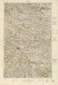
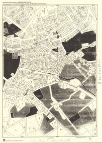
Map, 1:100,000 LENS Edition 2, 1915, Minor Corrections 27/10/1916
Topographical Map. Full colour. Attached by glue to matching copy of 1:100,000 map sheet, 'Amiens' (as per 9002-Bob).snape collection -
 Bendigo Historical Society Inc.
Map - CAMPBELL COLLECTION: BENDIGO AND DISTRICT MAPS
Map. Sedgwick. Parishes of Strathfieldsaye, Lyell and Sedgwick. Scale 20 chains to 1 inch. (number 359 in map cupboard 1)map, bendigo, agricultural lands -
Bendigo Historical Society Inc.
Map - CAMPBELL COLLECTION: BENDIGO AND DISTRICT MAPS
Map. Lyell, Parishes of Sedgwick, Eppalock and Lyell. Scale 20 chains to 1 inch. (number 348 in map cupboard 1)map, bendigo, agricultural lands -
Bendigo Historical Society Inc.
Map - MANDURANG, November 6th 1854
Map: The village of Mandurang situated about 6 miles from Sandhurst, Parish of Mandurang ( number 155 in Map Cupboard 1)map, bendigo, village, mandurang -
Bendigo Historical Society Inc.
Map - BENDIGO WEST IRRIGATION SETTLEMENT, 27/07/1910
Map: bendigo West Irrigation Settlement, Parish of Sandhurst, County of Bendigo. Parish plan ( number 193 in Map Cupboard 1)map, bendigo, irrigation settlement, bendigo west irrigation settlement -
Bendigo Historical Society Inc.
Map - BENDIGO WEST IRRIGATION SETTLEMENT, 13/02/1909
Map: Bendigo West Irrigation Settlement, Parish of Sandhurst, County of Bendigo. Parish plan. ( number 191 in Map Cupboard 1)map, bendigo, irrigation settlement, bendigo west irrigatioon settlement -
Bendigo Historical Society Inc.
Map - GEOLOGICAL MAP BENDIGO GOLDFIELD, See above
Map: Geological map of the Bendigo Goldfield comprising 2 sheets , Numbered 9358a and 9358b. Prepared in 1923 re-issued in 1936map, bendigo, geological, geological map, bendigo goldfield -
Bendigo Historical Society Inc.
Map - BENDIGO, October 1st 1893
Map: Bendigo, Plan of the whole county of Bendigo showing areas now available for selection (number 256 in map cupboard 1)map, bendigo, lands available for selection, bendigo, land available for selection -
Bendigo Historical Society Inc.
Map - TOWNSHIP OF HEAHCOTE SHEET 1, 29/07/1935
Map: Township of Heathcote sheet 1, parish of Heathcote, County of Dalhousie. Parish plan (number 253 in map cupboard 1)map, dalhousie, township, heathcote, conty of dalhousie -
Bendigo Historical Society Inc.
Map - PARISH OF EGERTON, 19/03/1894
Map: Parish of Egerton, Settlement on Lands Act 1893, County of Bendigo. Parish plan ( number 245 in Map Cupboard 1)map, bendigo, settlement on lands act 1893, egerton, settlement on lands act 1893. -
Bendigo Historical Society Inc.
Map - SANDHURST (PART), Circa 1880's
Map: Parish plan showing an area from McKenzie/View streets to Long Gully ( number 232 in Map Cupboard 1)map, bendigo, parish plan, sandhusrt, mckenzie street , view street, long gully -
Bendigo Historical Society Inc.
Map - LOCKWOOD, November 25th 1855
Map: Garden Allotments within the Town Reserve of Lockwood on the Bullock Creek. Parish plan (number 273 in map cupboard 1)map, bendigo, parish plan, lockwood, garden allotments, bullock creek -
Koorie Heritage Trust
Document - Printed Sheets, McBryde, I et al, The Distribution of Greenstone Axes in Southeastern Australia: preliminary report: Mankind Vol. 10 No. 3 June 1976: 163-174 "Wil-im-ee Moor-ring" or Where do axes come from? Mankind Vol. 11 1978: 354-82, 1976
Two papers outlining the greenstone sites in Victoria, their distribution and role in exhange in the communities.163-174 P.; maps; figs.refs.; bib. and vol 11 354-382 P.; maps; notes; graphs;tables; bib. Two papers outlining the greenstone sites in Victoria, their distribution and role in exhange in the communities. greenstone - quarry sites - victoria., aboriginal greenstone ?xes - south-eastern australia - sites., exchanged - greenstone - aborighinals, victoria. mount camel. -
 Ballarat Tramway Museum
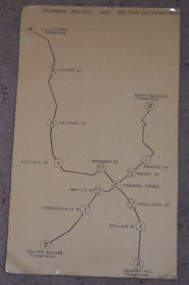
Map, "Bendigo Tramway Routes and Section Destinations", c1970
Demonstrates the layout of the Bendigo tramways, extracted from the Fare Schedule. Basis of production, source unknown. Associated with Eildon Hogan.Plastic coated, card mounted map showing diagrammatic routes of map of Bendigo routes, extracted from the SEC Fare Schedule.trams, tramways, bendigo, map -
 Bendigo Historical Society Inc.
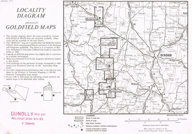
Document - JOAN O'SHEA COLLECTION: LOCALITY DIAGRAM AND NOTES FOR DUNNOLLY GOLDFIELD MAPS
Joan O'Shea Collection. Locality diagram and notes for goldfield maps. Dunolly map set. Wedderburn, Berlin, Dunolly, Maryborough, Avoca.mining, company exploration, dunolly map set. -
 Bendigo Historical Society Inc.
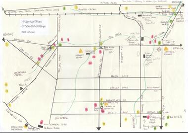
Map - MAP OF HISTORICAL SITES OF STRATHFIELDSAYE
On one side a map of the historical sites of Strathfieldsaye (not to scale) and on the other ten photographs of people and sites and a list of the sites marked on the map.bendigo, history, strathfieldsaye -
Camberwell Historical Society
Ephemera - Objects, John Niemann et al, Camberwell Urban Conservation Study, 1989-1992
Letters re: Urban Conservation Study with map, Conserving Camberwell questionnaire, Urban Conservation Study booklet, and City of Camberwell mapcamberwell, urban conservation study -
 Bendigo Historical Society Inc.
Map - LONG GULLY HISTORY GROUP COLLECTION: MAP - EAGLEHAWK ROAD
BHS CollectionMap of part of Eaglehawk Road showing a Bike Ride Trail. Map is dated September 01, 1998, Scale 1:5000.bendigo, history, long gully history group, the long gully history group - map - eaglehawk road, natural resources and environment, bike ride trail -
 Bendigo Military Museum
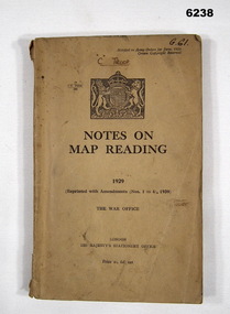
Manual - Notes on Map Reading 1929 - The War Office, 30.06.1939
Instruction in Map reading. The object of map - reading is to tender possible the clear and accurate visualization of the ground from a map productBrown Cardboard book, A5 Size, Several insets. Reprinted with Amendments 1-4 1939, 95 pages.royal australian survey corps, rasvy, fortuna, army survey regiment, army svy regt, asr -
 Bendigo Military Museum
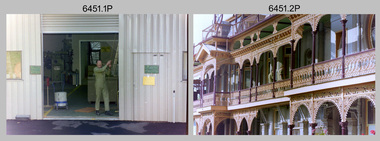
Photograph - Lithographic Squadron Personnel and Equipment, Army Survey Regiment, Fortuna, Bendigo, c1990
These 28 photographs of Lithographic Squadron personnel and equipment was taken at Fortuna, Bendigo circa 1990. The photos were taken on the east side of Fortuna Villa, the Print Room’s map trimming and dispatch work area and the inside and outside Air Survey Support Section (BARCRO).These 28 photographs of Lithographic Squadron Personnel and Equipment was taken at Fortuna, Bendigo circa 1990. The 35mm colour photograph negatives were scanned at 96 dpi and are part of the Army Survey Regiment’s Collection. .1) - Photo, colour, c1990. RAEME and maintenance support, unidentified civilian. .2) - Photo, colour, c1990. Eastern side of Fortuna Villa, unidentified, CPL Le-Anne (Smallshaw) Shirley. .3) - Photo, colour, c1990. Eastern side of Fortuna Villa, SGT Gary Kerr. .4) - Photo, colour, c1990. Eastern side of Fortuna Villa, CPL Roy Hicks. .5) - Photo, colour, c1990. Eastern side of Fortuna Villa, unidentified. .6) - Photo, colour, c1990. Unidentified passing Q-Store & Transport Compound. .7) - Photo, colour, c1990. Data Management & Map Library. .8) - Photo, colour, c1990. Unidentified officer passing Q-Store heading up to Map Library. .9) - Photo, colour, c1990. Eastern side of Fortuna Villa, SPR Michelle Withers. .10) - Photo, colour, c1990. Unidentified RAEME soldier passing Q-Store heading up to Map Library. .11) & .12) - Photo, colour, c1990. Delivery of bulk map printing paper. WO2 Jeff Willey on forklift, unidentified. .13) & .14) - Photo, colour, c1990. Print Room, Wohlenberg MCS-2 guillotine. .15) to .18) - Photo, colour, c1990. Air Survey Support Section (BARCRO), Carl Zeiss Rectifying Enlarger. .19) - Photo, colour, c1990. Air Survey Support Section (BARCRO), film contact frame. .20) - Photo, colour, c1990. Air Survey Support Section (BARCRO), Pakotone film development processors. .21) & .22) - Photo, colour, c1990. Air Survey Support Section (BARCRO) entry/exit. .23) & .24) - Photo, colour, c1990. Air Survey Support Section (BARCRO) miscellaneous equipment. .25) & .26) - Photo, colour, c1990. Air Survey Support Section (BARCRO), CPL Warren ‘Waldo’ Shirley. .27) & .28) - Photo, colour, c1990. Outside Air Survey Support Section (BARCRO), L to R: WO1 Peter Coombes, CPL Warren ‘Waldo’ Shirley..1P to .28P – There are no annotations.royal australian survey corps, rasvy, army survey regiment, army svy regt, fortuna, asr, litho sqn -
 Bacchus Marsh & District Historical Society
Map, Subdivision of the Manor House Property Bacchus Marsh c.1908
This land sales plan shows allotments of land offered for sale in the inner township area of Bacchus Marsh in 1908. The land put up for sale was from the estate of the late Mr and Mrs J.E. Crook. That being James Elijah Crook and his wife Harriet, (nee Athorn). The Crooks had been resident in Bacchus Marsh since the 1840s and were prominent members of the community. They were prominent in the business, social and civic affairs of the town and district. In the 1850s the Crooks acquired the Manor House and nearby land once owned by the Bacchus family. James Crook died in 1889. When Harriet Crook died in February 1908 their estate was offered for sale. This included the large stone home known as the Manor House and various parcels of land including around 50 allotments of land near the Manor House, bounded by Young, Lerderderg, Crook and Main Streets. Most of these allotments of land were sold in October 1908. The Manor House itself was passed in at the sale and continued to be owned by the Crook family for several decades after 1908.A single page map on a single page of a bound volume of maps. The map shows portions of land for sale from the subdivision of the Manor House property in Bacchus Marsh in 1908. The names of most of the buyers of the portions of land have been hand-written into the various allotments they purchased. The maps are pasted into a bound volume containing 76 maps or plans in total. High resolution digital image stored on BMDHS computer network. bacchus marsh victoria maps, land sales bacchus marsh, manor house bacchus marsh, crook family bacchus marsh -
 Marysville & District Historical Society
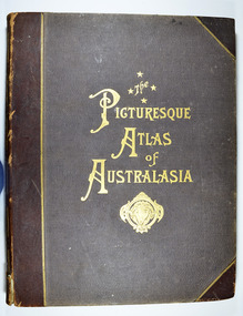
Book - Hardcover book, Picturesque Atlas Publishing Company Limited, The Picturesque Atlas of Australasia-Volume 2, 1886
The Picturesque Atlas of Australasia-Volume 2Hardcover. Cover is brown with the title in gold lettering. Underneath the title is a symbol of a solid wreath surrounding the head of a ram. Three fold-out maps are included; Railway Postal and Telegraph Map of South Australia, 1888; Railway Postal & Telegraph Map of Queensland, 1888; Railway, Postal, Telegraph and Rainfall Map of Tasmania 1889. non-fictionThe Picturesque Atlas of Australasia-Volume 2atlas, australasia, history -
Bendigo Historical Society Inc.
Map - CAMPBELL COLLECTION: BENDIGO AND DISTRICT MAPS, 23-4-29
Map. Whirrakee, Parish of Whirrakee, Total area 4419 acres, scale 20 chains to 1 inch. Unused water race in centre of map. Eucalypt Oil Distillery, bottom of map. Prepared in W.P.B. from Assessor's Plan and Parish Plan. G.W.Latimer 23-4-29. (number 385 in map cupboard 1)G.W.Latimermap, bendigo, agricultural lands -
 Victorian Aboriginal Corporation for Languages
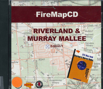
CD-ROM, Country Fire Services South Australia, FireMapCD Riverland &? Murray Mallee, 2001
The area covered by this map is the same as the CFS Riverland & Murray Mallee Map Book. The area covered adjoins the Mount Lofty Ranges map book on the eastern boundary at Murray Bridge, north to Morgan and east to Renmark and the State Border. It extends southwards to join the northern boundary of the Lower South East map book at Padthaway.CD-ROMfire protection, victorian maps -
University of Melbourne, Burnley Campus Archives
Plan - Photocopy, Sunshine Planning Scheme, 1993
Photocopies. 18.02.1993. (1) 5 copies Map User Guide - Sunshine Planning Scheme. List of Zones, Reservations and additional Planning Controls. (2) Sunshine Planning Scheme - Local Section. Zones and Reserved Land Map No 2. (3) Map No 3. (4) Map No 4. Used in planning Native Garden Woodlandsunshine, reservations, native garden, planning scheme, victoria department of planning and development -
 Eltham District Historical Society Inc
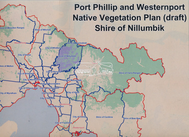
Book, Port Phillip and Westernport Native Vegetation Plan (draft), Shire of Nillumbik
Entire report available www.ppwema.vic.gov.au -
 Greensborough Historical Society
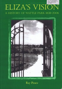
Book, Ray Pearce, Eliza's vision: a history of Wattle Park 1838-2006, 2006
An outline of the history of Wattle Park (Vic).207 p., illus., colour map.non-fictionAn outline of the history of Wattle Park (Vic).urban parks - melbourne, wattle park (vic.), parks - melbourne - history -
Greensborough Historical Society
Newsletter, Greenhills and North Greensborough Progress Association, Community News: official journal of the Greenhills and Nth. Greensborough Progress Association and the Apollo Parkways Progress Association. July 1978. Edition No. 6/78, 07/1978
Orchids can still be found!, Yandell Bushland Reserve: a management study, School news, This and that, Did you know?, From the Council Chamber, A quarry in Plenty???, The restoration of access from Pinehills to Greensborough,Newsletter, 16 p., illus., map.greenhills and north greensborough progress association, greenhills, apollo parkways progress association, apollo parkways -
 Greensborough Historical Society
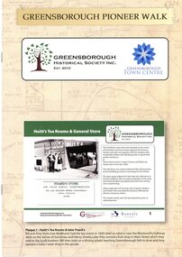
Booklet, Greensborough Historical Society Inc, Greensborough Pioneer Walk, 2021
A guide to the historic photographs which have been mounted on 12 plaques in Greensborough Town Centre. 8 p., photographs, captions and mapgreensborough, pioneer walks, greensborough historical society -
 Greensborough Historical Society
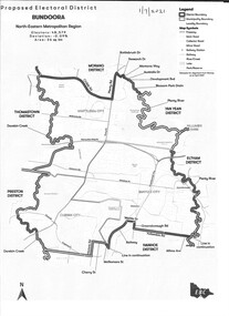
Map - Map (Copy), Electoral Boundaries Commission, Proposed electoral district: Bundoora, 01/07/2021
Proposed revised electoral boundaries for the electoral district of Bundoora (North-Eastern Metropolitan Region) as at 01/07/20211p. black and white copy of mapelectoral boundaries, bundoora - maps, victoria - parliament