Showing 14064 items
matching properties
-
 Bendigo Historical Society Inc.
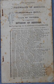
Administrative record - Electoral Roll, 1915
Voting registers, or electoral rolls, are a census of those who were eligible to vote. They are valuable because a country-wide census wasn't taken until 1911. Early electoral rolls give an individual’s name, residence, status of property occupation/ownership, and the nature of the rateable property. Electoral rolls are arranged by electoral district and subdistrict. Electoral rolls were published by each state during election years.Commonwealth of Australia Electoral Roll, State of Victoria, Division of Bendigo, 1915 (Second Print). Roll of electors for the Sub Division of Eaglehawk. Includes Name, Address, Occupation and gender. Assembled and fastened with two large staples.electoral rolls, voting in bendigo -
 Bendigo Historical Society Inc.
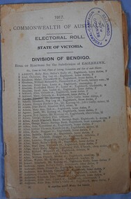
Administrative record - Electoral Roll, 1915
Voting registers, or electoral rolls, are a census of those who were eligible to vote. They are valuable because a country-wide census wasn't taken until 1911. Early electoral rolls give an individual’s name, residence, status of property occupation/ownership, and the rate value of the property. Electoral rolls are arranged by electoral district and subdistrict. Electoral rolls were published by each state during election years.Commonwealth of Australia Electoral Roll, State of Victoria, Division of Bendigo, 1917. Roll of electors for the Sub Division of Eaglehawk. Includes Name, Address, Occupation and gender. Assembled and fastened with two large staples.electoral rolls, voting in bendigo -
 Bendigo Historical Society Inc.
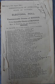
Administrative record - Electoral Roll, 1915
Voting registers, or electoral rolls, are a census of those who were eligible to vote. They are valuable because a country-wide census wasn't taken until 1911. Early electoral rolls give an individual’s name, residence, status of property occupation/ownership, and the rate value of the property. Electoral rolls are arranged by electoral district and subdistrict. Electoral rolls were published by each state during election years.. Commonwealth of Australia Electoral Roll, State of Victoria, Division of Bendigo, 1941. Roll of electors for the Commonwealth Division of Bendigo, State Assembly of Bendigo and Roll of electors for the Subdivision of Bendigo. Includes Name, Address, Occupation and gender. Assembled and fastened with string.electoral rolls, voting in bendigo -
 Bendigo Historical Society Inc.
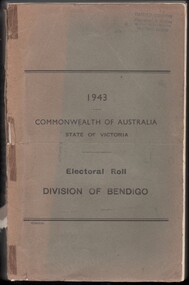
Administrative record - Electoral Roll, 1915
Voting registers, or electoral rolls, are a census of those who were eligible to vote. They are valuable because a country-wide census wasn't taken until 1911. Early electoral rolls give an individual’s name, residence, status of property occupation/ownership, and the rate value of the property. Electoral rolls are arranged by electoral district and subdistrict. Electoral rolls were published by each state during election years... Commonwealth of Australia Electoral Roll, State of Victoria, Division of Bendigo, 1943 (made up to December 1942). Roll of electors for the Commonwealth Division of Bendigo, State Assembly of Bendigo and Roll of electors for the Subdivision of Bendigo. Includes Name, Address, Occupation and gender. Assembled and bound with string.Stamp of owner Harold Curnowelectoral rolls, voting in bendigo -
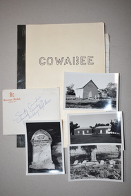 Warrnambool and District Historical Society Inc.
Booklet with Photographs, Stan Baulch, Cowabee, 1978 (booklet)
These items concern the history of the Baulch family ownership of Cowabee, a large grazing property in the Riverina in N.S.W. In the 1870s Samuel Baulch, the son of pioneer Kirkstall settlers, Francis and Ann Baulch, established a property in the Macarthur/Hawkesdale area called Rose Park. In 1893 he acquired Dunmore, a nearby property, and Rose Park became part of that estate. In 1910 Samuel Baulch purchased Cowabee in N.S.W. and Stan Baulch, the son of Samuel and Eliza, later managed Cowabee for some years. After Samuel’s death Stan Baulch and his two brothers split up Dunmore and Stan acquired the eastern third which he named Rose Park. Cowabee was sold in 1922. This booklet and associated material is of some historical interest as a summary of the history of Cowabee, one of the properties owned by the Baulch family of the Western District in the early 20th century. It will be of some use to researchers, with the photographs an added bonus. .1 This is a booklet of 41 pages with a buff-coloured paper cover with a black tape binding. The front cover has a title in hand-printed lettering and the back cover has a red stamp (partly obliterated). The booklet contains typed information on Cowabee Station. .2 This is a small envelope containing six black and white photographs, all with handwritten information on the back. .21 & .22 These are two loose sheets of writing pad paper with handwriting in blue ink. .1 Cowabee .2 Snaps Cowabee Church Cemetry(sic) & pise buildings left there cowabee station, n.s.w., baulch family western district victoria, history of warrnambool -
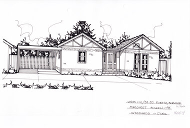 Whitehorse Historical Society Inc.
Artwork, other - Ink Line Drawing, Margaret Picken, Units 1-10/35-37 Ruby St., Burwood, 1995
A property illustration by Margret Picken Commissioned by the real estate agency Woodards for the purpose of advertising Units 1-10/35-37 Ruby St., Burwood in 1995. Made by using Rotring ‘Rapidigraph’ drafting pens with Rotring ink on Rapidigraph polyester drafting film, double matte. This property is listed as having had unit 10 sell for $149,000 in 1995 Trained as a cartographic draftsman within the mining industry, Margaret Picken is an artist who worked producing property illustrations for real estate agencies in eastern suburbs of Victoria from 1983-2005. Retiring from the industry as technological changes favored coloured photography over illustrations, and commissioning companies over sole contractors.This artwork is of Historical Significance as a record of local domestic architecture.A black ink line drawing on drafters film by Margaret Picken, of Units 1-10/35-37 St., Burwood. a single story brick house with two pitched roofs either side of a central porch and front door. There is a connected carport on the left. There are two hole punches near the upper edge.Units 1-10/35-37 Ruby St., Burwood Margaret Picken - 95 Woodards - c'well whitehorse historical society, schwerkolt cottage, housing, architecture, margaret picken, burwood, house, garden -
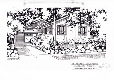 Whitehorse Historical Society Inc.
Artwork, other - Ink Line Drawing, 9 Tainton Rd., Burwood, circa 1990's
A property illustration by Margret Picken Commissioned by the real estate agency Woodards Box Hill for the purpose of advertising 9 Tainton Rd., Burwood circa 1990's Made by using Rotring ‘Rapidigraph’ drafting pens with Rotring ink on Rapidigraph polyester drafting film, double matte. This property is listed as having had unit 10 sell for $137,000 in 1990 Trained as a cartographic draftsman within the mining industry, Margaret Picken is an artist who worked producing property illustrations for real estate agencies in eastern suburbs of Victoria from 1983-2005. Retiring from the industry as technological changes favored coloured photography over illustrations, and commissioning companies over sole contractors.This artwork is of Historical Significance as a record of local domestic architecture.A black ink line drawing on drafters film by Margaret Picken, of 9 Tainton St., Burwood. A single story brick house with multiple pitched roofs, to the left is a driveway leading to a garage in the background. and in front of the house is a lawn enclosed by a low rock fence and shrubbery. There are two hole punches near the upper edge, And a black wear mark running left below the upper edge9 Tainton Rd., Burwood Margaret Picken Woodards - Box Hillwhitehorse historical society, schwerkolt cottage, housing, architecture, margaret picken, burwood, house, garden -
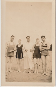 Melbourne Legacy
Photograph, Somers Camp, c1930
A black and white photo of Legatee Stanley Savige and four others in swimwear standing on a beach. In the early years, Legacy organised outings to the property of Legacy founder, Legatee Stan Savige, who had a place in Balnarring close to the beach. Permanent camp buildings were built in 1930. In 1930 Lord Somers (Governor of Victoria) also started a camp at a nearby property and the area was renamed Somers. Legacy Somers Camps continued intermittently at Stan's property until it was decided in 1951 to make other arrangements for holidays. Legatee Savige was the key founder of Legacy in 1923. This photo was with other photos from the early days of Legacy, including cricket team, football team, and camps at Balnarring/Somers.Legatee Savige was an important figure in Legacy's history and his property at Balnarring became very important for Legacy providing outings and camps for junior legatees.Black and white photo of Legatee Savige with 4 others on a beach.Stamped 'Kodak print S 856' on back in grey ink.beach, swimwear, stan savige, legacy somers camp -
 Warrnambool and District Historical Society Inc.
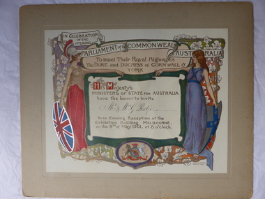
Certificate, Duke of Cornwall
This certificate is an invitation to the Evening Reception in Melbourne in 1901, an event which was part of the celebrations in Melbourne to commemorate the Federation of the six colonies into the six States of Australia in January 1901. The certificate was sent to the invitees after the event as a souvenir of the occasion. The certificate was designed by the artists Julian and Howard Ashton and lithographed and issued by Sands and McDougall Limited of Melbourne. This particular certificate was sent to George Rolfe and his wife Annie. George Rolfe (1836-1919), a tea merchant from Melbourne, began buying blocks of land near the mouth of the Hopkins River in the 1870s. By the early 1880s he had acquired 50 acres of land in the town and several nearby farming properties. He used the buildings on the land at the mouth of the River Hopkins as holiday accommodation and called this property Lyndoch. Rolfe improved this property adding stables, jetty, boathouse, bone and chaff sheds, reservoir and windmill and extensive gardens. Rolfe spent most of his later life at Lyndoch. Today the property is the site of an Aged Care Facility. This certificate is of considerable importance for two reasons: 1. It is an attractive and valuable memento of a signal event in Australia’s history – the Federation of the States in 1901. 2. The certificate was an invitation to Mr and Mrs George Rolfe. Rolfe was a prominent person in Warrnambool in the late 19th and early 20th centuries. This is a multi-coloured certificate mounted on a piece of grey cardboard. The certificate is highly embossed and has a figure of Britannia in a red dress and a mailed vest holding a shield with the Union Jack emblem. Britannia is extending her hand to a figure of a younger woman representing Australia. This figure is dressed in blue and holds a shield which has a blue cross with white stars. The borders have vines and vine leaves and the Royal Crest is at the base of the certificate. The names of the invitees are handwritten in black ink. ‘In Celebration of the Opening of the Parliament of the Commonwealth of Australia, To Meet Their Royal Highnesses, the Duke and Duchess of Cornwall and York, His Majesty’s Ministers of State for Australia have the honor to invite Mr & Mrs G. Rolfe to an Evening Reception at the Exhibition Building, Melbourne on the 9th of May 1901, at 8 0’clock’. george rolfe of lyndoch, warrnambool, federation of australia, history of warrnambool, george rolfe -
 Glen Eira Historical Society
Plan - Centre Road, 734, Bentleigh East
A one page typed letter, dated 30/09/1970 addressed to S P Simmonds Estate Agency from William Lasica and Co Solicitors requesting a valuation of the property at 734 Centre Road, Bentleigh East. The file also includes four pages of handwritten, undated and unattributed working notes with property description, calculations and a rough plan (96mm x 94mm) of the ground floor of the building for the valuation. Also included in the file is a two page duplicate copy of a typed letter, dated 08/10/1970 from W V Scott to William and Lasica Co Solicitors containing the valuation of the relevant property and rental details. The file also includes a one page photocopy of a handwritten document dated 15/11/1967. It gives details of a previous mortgage. The file also includes a photocopy, dated 26/09/1970, of the Certificate of Title of Lot 6 of Subdivision No 60044 Parish of Moorabbin. It includes a plan of the property (139mm x 123mm).klauss anna sara, klauss edward, green william james, green margaret estelle, green william thomas, myers thomas lee, lombard joseph patrick, graham george kinnell, tobin thomas norman, mcintosh edward joseph, bentleigh east, east bentleigh, centre road, bentleigh station, omeo court, east boundary road, s p l constructions pty ltd, r k c nominees pty ltd, maryland street caulfield investors, flats, land values, land titles, rents, renting, \ -
 Glen Eira Historical Society
Photograph - Blencairn
Four items about this mansion: 1/A black and white copy of a photograph (140mm x 110mm) of a Caulfield property with 2 adults and 4 young people positioned across the garden 2/Photocopied pages (2) out of the article '100 Years of Local Government - Early Caulfield' contained in 'Caulfield Centenary 1857-1957' by Mrs A. P. Bell showing the same photograph above as 'Slaney's Home, Hawthorn Road, Cnr Glen Eira Road'. Refer file 1441C for orignial copy of this booklet. 3/A one page typed document of the Caulfield Historical Society that identifies the property in the photograph as a Caulfield home and requests help in further identifying the property. The document contains handwritten notes concerning the property’s identification as 'Slaney's Home' and 'Blencairn'. 4/Additional research notes of cataloguer Lee Johns, taken 12/08/2011, concerning the identification and occupation of the house shown in the photograph and sourced from the book 'Caulfield’s Heritage' Volume 1 1989.blencairn, slaney’s home, hart thomas, centenaries, mansions, hawthorn road, slaney family, blencairn, caulfield, bell a. p. mrs, solomon geulah dr, glen eira road -
 Kiewa Valley Historical Society
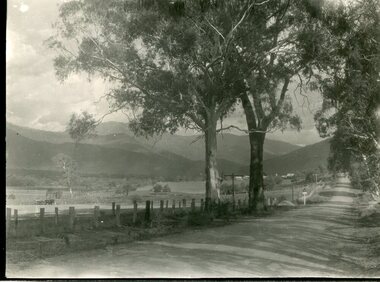
Photograph - Tawonga Valley 1937, 06/05/1937
Hume and Hovell discovered the area in 1824 and by the end of the 19th century the valley was transformed by logging, dairy and beef cattle properties and tobacco farms. Historic photograph of the Tawonga Valley as it appeared in May 1937Black and white photograph of Tawonga Valley looking towards Mt BeautyHandwritten on rear of photograph in pencil - Thursday May 6th, 1937. Tawonga Valleytawonga, kiewa valley -
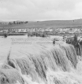
 Eltham District Historical Society Inc
Photograph, Fay Bridge, Longridge, Alexander Road, Warrandyte, 4 May 2019
Situated on the Warrandyte side of the Yarra River opposite Glynn's Dairy Farm, North Warrandyte, the property is in ruins and remains fenced off as of 2023fay bridge collection, glynns, longridge, ruins, warrandyte, 2019-05-04, alexander road -
 Eltham District Historical Society Inc
Album - Photograph, J.A. McDonald, Eltham-Yarra Glen Road, 19 Oct. 1956
Dixons Creek Road 19th October, 1956 Scour developing back onto road from Smedley’s property near Blease RoadRecord of various Shire of Eltham infrastructure works undertaken during the period of 1952-1962 involving bridge and road reconstruction projects, sometimes with Eltham Shire Council Project Reference numbers quoted. It was during this period that a number of significant improvements were made to roads and new bridges constructed within the shire that remain in place as of present day (2022). In many situations, the photos provide a tangible visible record of infrastructure that existed throughout the early days of the Shire. The album was put together by or under the direction of the Shire Engineer, J.A. McDonald.infrastructure, road construction, shire of eltham, bridge construction, eltham-yarra glen road, 1956-10-19, dixons creek bridge, dixon's creek road, floods -
Glen Eira Historical Society
Document - Wisteria, Normanby Road, 135, Caulfield North
Caulfield Conservation study by Andrew Ward on the residence Wisteria. Includes history of the property, the owners from 1897 to 1905, and a description of the architectural features.caulfield north, normanby road, wisteria, architectural features, weatherboard buildings, house names, mayfield grove, blake a.h., luke ida mrs., luke edmund, artists, queen anne style, ward andrew, e.s.a. bank -
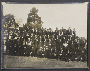 Mission to Seafarers Victoria
Photograph, Gathering - New Year's Day 1909
An outing for a large number of seafarers to one the picturesque properties made available to them on public holidays, in this case New Year's Day 1909 Small monochrome photograph, depicting a formal arrangement of four rows of a large number of men, outdoors 1909, new year, picnic -
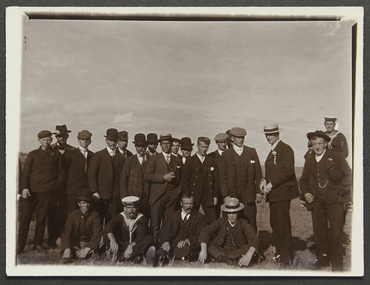 Mission to Seafarers Victoria
Photograph - Photograph, Sepia, Picnic at Orchard House, Cup Day 1907
Typical outdoor photo of group of seafarers benefitting from a mission excursion out to one of the larger properties, in this case Orchard House, Malvern.Group o 21 seamen standing or sitting on the grass, with Reverend Gurney Goldsmith standing on the right.orchard house, 1907, malvern, george higgins, picnic, cup day, beatrice elizabeth higgins (nee shuter), charles shuter, picnics, entertainments, social events, goldsmith album, bowler hat, boater hat, sailor cap -
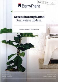 Greensborough Historical Society
Booklet, Barry Plant Greensborough 3088 Real estate update 2019, 2019_
Barry Plant Greensborough 3088 Real estate update 2019, market report 2019. Includes properties for sale or sold in the Greensborough area.12 pages. black text and colour images.real estate, greensborough houses -
 Greensborough Historical Society
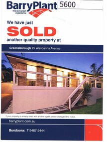
Advertising Leaflet, 25 Wanbanna Avenue Greensborough, 30/05/2012
25 Wanbanna Avenue Greensborough, Notice of sale of property; sold 30/05/2012 for $480,000, previously sold July 2011 for $502,000Real Estate advertising leaflet, one card, printed in colour both sides -
 Greensborough Historical Society
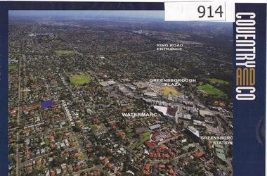
Photograph, Diamond Valley Leader, Greensborough: Aerial photograph, 21/05/2013
This advertisement for a property at 95 Alexandra Street Greensborough includes several aerial photographs of Greensborough with the Ring Road, Watermarc and Greensborough Plaza marked.An aerial view of Greensborough and surrounding areas in 2013.Colour advertisement including aerial photograph of Greensborough.alexandra street, greensborough plaza, watermarc -
 Greensborough Historical Society
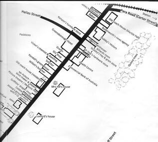
Map, U. M. Woods, Map of Greensborough early to mid 1950s, 1839-1959
Map of Main and Grimshaw Streets Greensborough by U.M. Woods. Properties shown are drawn from memory and represent the town in the early to late 1950s.Sketch map, black on white paper. letter of explanation.u. m. woods, grimshaw street greensborough -
 Orbost & District Historical Society
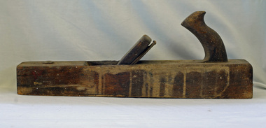
trying plane, first half 20th century
A heavy trying plane would have been used in construction work on rural properties. It can be used for planing hard, difficult timbers.Tools such as this would have been used in the construction of local homes, or rural outbuildings in early Orbost.. It is representative of an era before power tools. A long, heavy wooden plane used in smoothing the edges of roughly planed wood.woodwork tools plane-trying -
 Federation University Historical Collection
Documents, Holmes Family of Ascot: Private papers - Wills, Financial Statements
Private papers relating to the Holmes Family at Ascot. It includes Wills, property settlements, land transfers, wool prices and asset distribution to the family.edith holmes, registration of a firm, live stock prices, lamb numbers, affidavit and statement, memorandum of agreement, land purchase agreement, contractor's account and receipt, solicitor - cuthberts, transfer and conveyance paperstax return, will of violet holmes, distribution of estate of violet holmes, administration account, wool results from dennys,lascelles -
 Ringwood and District Historical Society
Work on paper, Sepia Photogragh of unknown man, on paper in cardboard cylinder with Paris address dated 1903 (In Wieland family collection)
Ernest Ferdinand Wieland was Carl's son and one of the earliest pupils at BayswaterSchool . The title of the property was transferred to him on his father's death in 1904..Cardboard cylinder with partial Paris address with" boutique de portrait " on it and partial hand written address with "Tasma" just visible.Inside a sepia portrait of possibly Ernest Ferdinand Wieland as a young man. Dated 1903. -
 St Kilda Historical Society
Administrative record - Notice, Valuation and General Rate Notice, 1948
A valuation and general rate notice that was issued in 1948 by the City of St Kilda for property held by the 2nd St Kilda Boy Scouts Troop.Pink coloured paper printed in black on both sides and inscribed with typed details in blueTyped details of addressee: Trustees 2nd. St. K. Boy Scouts Troop, 61b Pakington Street, St Kilda S.2. Typed details of assessment: no. 7702/4; location 59a/61a Pakington Street; net annual valuation 60 pounds; general rate 6 pounds 15 shillings. Valuations same as last year. Stamped notation that the general rate was twenty seven pence in the pound as made by the City of St Kilda on 10th November 1947boy scouts, city of st kilda, st kilda rates -
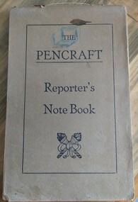 Tatura Irrigation & Wartime Camps Museum
Book - Note book, Reporter's Note Book, 1940's
Property of former internee, Eberhard Schuster, at Camp 1 Tatura. Used as a school book/note taker. Has maths notes in it in German.Soft covered buff coloured reporters notebook, stapled at spine (narrow edge). Lettering on cover in black, "the Pencraft Reporter's Note book" logo below. Two crossed torches. Entries in pencil, mainly mathematics.has a blue cube drawn around "The"eberhard schuster, camp 1 tatura, camp education -
 National Wool Museum
Sample, Wool
From Ian and Janet Harrison's Camden Park property, N.S.W. direct descendant flock, shorn 2nd Nov, 1987. (Tom Crocker)sheep breeding, wool history, camden park estate, nsw, wool - history -
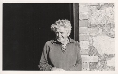 Rutherglen Historical Society
Image, 1970s
Cliff Booth second generation winemaker and owner of Booth's Taminick Cellars.This property has been owned by the Booth family since 1904Black and white photograph of a silver haired man standing in the doorway of a winery.On back of photo: "S/S [upper case D in small circle] Booth Bros."wineries, north east victoria, wine industry, booth brothers, cliff booth, taminick, glenrowan -
 Whitehorse Historical Society Inc.
Photograph, Colombo Street Mitcham
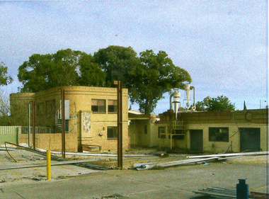
Property in Colombo Street Mitcham was opposite the train station exit, bought by NADRASCA to train and employ disabled persons. Sold to a developer in 2002Coloured photo of Brewer family house and factory on Colombo Street Mitcham c2002. Factory manufactured bowling balls and tennis racquetnadrasca, colombo street, mitcham -
 Whitehorse Historical Society Inc.
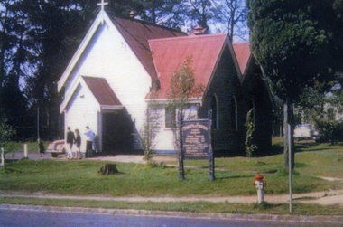
Photograph, St Luke's, Vermont
In 1922 the building was extended. In 1961 it was moved to it's present location at the rear of the church property. In 1999 it was restored and is now know as 'The Pioneer Church'Coloured photo of the original St Luke's Church, Vermont. It was erected on the corner of Mitcham Road & Canterbury Roads Vermont, and dedicated on 3rd September 1907st luke's vermont, canterbury road vermont