Showing 11583 items
matching surveyor-general
-
 University of Melbourne, Burnley Campus Archives
Newspaper - Newspaper Cutting, The Argus, Horticultural Society of Victoria, 1860
Copy of article in "The Argus" 19 January, 1860 p1. Adjourned annual general meeting. Discussion of threat by Botanic Gardens to disallow its use by the Society.the argus, botanic gardens, horticultural society of victoria, annual general meeting -
 Linton and District Historical Society Inc
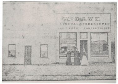
Photograph, Dawe's Store
The Dawe family shop is thought to have been in Sussex Street/Skipton Road, opposite Wishart's forge. W. Dawe is shown on the Township of Linton plan as the owner of Allotment 4, Section 1A. Municipal directories show "William Dawe, Fruiterer" in the 1880s, and from the 1890s "Thomas Dawe, Fruiterer". (Thomas was William Dawe's son.)A black and white copy of an original faded Photostat which shows three women standing in front of a building "Wm. Dawe General Storekeeper Fruiterer Confectioner".william dawe, shops, general store, sussex street, robert s. nelson (jnr) -
 Bendigo Historical Society Inc.
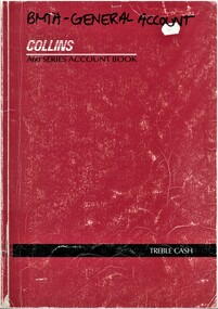
Book - BMTA COLLECTION: GENERAL ACCOUNT BOOK, 1992 - 2005
BHS CollectionBendigo Music Teachers Association General Account Book A4 red exercise Book White Pages Handwritten List of Members Letters Sent by Treasurer -
 Bendigo Historical Society Inc.
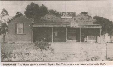
Newspaper - JENNY FOLEY COLLECTION: MEMORIES
BHS CollectionBendigo Advertiser ''The way we were'' from 2003. Memories: the Hart's general store in Myers Falt. This picture was taken in the early 1900s. The clip is in a folder.newspaper, bendigo advertiser, the way we were -
Glenelg Shire Council Cultural Collection
Plan - Plans / Line Drawing 'FV Kosmo' general arrangement, Apr-87
Front: '29' - black texta, top right cornerport of portland -
 Falls Creek Historical Society
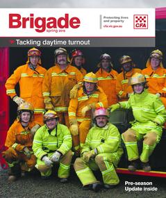
Magazine - Brigade Magazine Spring 2016
Brigade Magazine is issued to members of the Victorian CFA. The Spring edition of 2016 includes an article to acknowledge 21 years of service by the Falls Creek CFA. The article was written by Joy Nowakowski on behalf of the Falls Creek CFA with information provided by the Falls Creek Historical Society. Falls Creek Fire Brigade protects Falls Creek Village from fires throughout the year and supports other brigades to fight bushfires nearby and further away. In 2016 the brigade had 23 year-round volunteers. At a celebratory function at Falls Creek in June 2016, alpine pumper and brigade snowmobiles were on display. Falls Creek’s alpine pumper was the first of its kind in Australia. It had a pumping capacity of 4,000 litres a minute and its tracks enabled it to access areas of the village and ski fields. Until 2016 Falls Creek Village has been threatened by two major fires, the worst being in 2003 when CFA crews saved the village and the adjoining ski field infrastructure right at the boundaries. Snow making equipment was used to create a water/fog barrier that helped stop the fires from taking the village. The team that saved the village was considered heroic Support for fighting fires at Falls Creek dates back to 1956 but this support came from Mount Beauty, 30 kilometres down the mountain. Falls Creek locals were concerned by this, so used six available hydrants and a canvas hose to fight any fires on the mountain. In 1964 the SECV gave the village a trailer which could be used with both wheels and skis for summer and winter operations. But this trailer only lasted two years. In the early 1970s, the village was given a 2,000-gallon Ford Blitz 4WD truck, and additional equipment was quickly acquired by the village including a new locally-constructed trailer with a pumper unit. In the 1990s, a change in land status meant the Falls Creek area became the responsibility of CFA. This status was formalised in 1995 by a public meeting that formed Falls Creek Fire Brigade.This magazine is significant because it contains an article celebrating 21 years of Falls Creek CFA.A publication for CFA members which includes stories about recent incidents, brigades, training, events, community safety, health and safety and general CFA news. falls creek cfa, alpine firefighting, falls creek cfa 21 years -
 Bendigo Historical Society Inc.
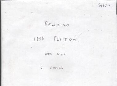
Document - CD OF BENDIGO 1856 PETITION, 1856
CD. Bendigo 1856 Petition. Original Petition from Sandhurst occupants to Major General Macarthur seeking to improve lands. See 1085, Box 500.bendigo, law, land improvements -
 4th/19th Prince of Wales's Light Horse Regiment Unit History Room
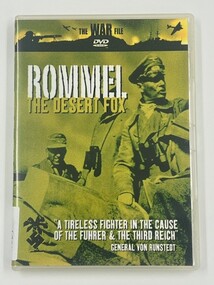
Film - DVD, Rommel The Desert Fox
RommelDVD in caseThe War File Rommel The Desert Fox "A tireless fighter in the case of the Fuhrer & the Third Reich" General Von Runstedtww2 -
 Federation University Historical Collection
Book, Sudtralasian Institute of Mining and Metallurgy, Latrobe Valley Brown Coal Resources: Geology, Exploration and Open Cut Mining Methods, 1960, 1960
Red hard covered book. Block Prints on white pages, and sections of the Yallourn-Morwell field and the Yallourn Coal Field Includes the following chapters: * Contribution of the Minerals Industry to the Development of Australia by G.R. Fisher (including Gold, Broken Hill Field, Coal, Copper, Tin) * PLanning and Development of the Brown Coal Open Cuts of the State Electricity Commission of Victoria by E.D.J. Stewart * Geology of the Latrobe Valley Coalfield by C.S. Gloe * Developments in Equipment USed for Overburden Removal and Coal Winning in the Brown Coal Industry by H.C.G. Rodgers / J.M. Alexander * Development of Methods for Use of Punch Cards in the Recording of Drill Clogs in the Exploration for Brown Coal by H.E.C. Beernon-fictionyallourn, morwell, loy yang, brown coal, latrobe valley, aus imm, australian institute of mining and metallurgy, ausimm -
 National Vietnam Veterans Museum (NVVM)
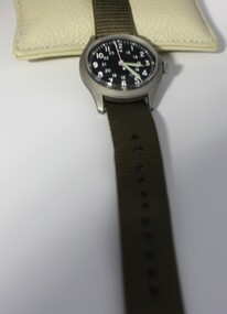
Functional object - Wrist watch
Standard issue Army wrist watch, commonly called a "Mickey Mouse" watch. This item was specifically made for Australian military use in 1970. A silver metal wrist watch with a glass cover over a round black face with white numbers for both 24 and 12 hour markings. The hands and 5-minute marks glow in the dark. Watch has wind up motion. Army issue green nylon band has a black clasp.Back: Watch. Wrist general purpose. MIL-W-46374A HAMILTON fsn6645-00-952-3767 Armymilitary issue, watch, 1200hr 2400hr watch, wrist watch, vietnam -
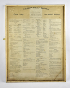 National Wool Museum
Photograph - Framed Printed Coursework, Gordon Institute of Technology, Textile College, 1950
Framed papers outlining the courses and coursework for the Textile College at the Gordon Institute of Technology in 1950. The courses include Woolcombing, Worsted Spinning, Woollen Yarn Manufacture, Designing, Weaving and Turning and Finishing. A digital copy of this item was made for the National Wool Museum Collection, with the original remaining with the donor. Digital TIFF file, 100 MB, showing image of framed printed paper.D.P.C. WILSON MEMORIAL BURSARIES. / Textile College / Gordon Institute of Technology. / GENERAL INFORMATION / TERM DATES 1950 ...courses, gordon institute of technology, textile college, geelong, woolclassing, weaving, spinning, coursework, 1950 -
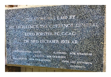 Camberwell RSL Sub-Branch
Foundation stone, Foundation stone of the Camberwell RSL laid by the GG Lord Forster on the 3 December 1921, 1921
First laid in 1921 at the Camberwell RSL in Canterbury Road Camberwell. Relaided in 1978 on a wall of a unit at the Camberwell Council retirement home on the same site after the Camberwell RSL was demolished. Discovered in 2017 by Peter Fielding and removed for rededication at the Camberwell RSL on the 100 centenary in 2019.Very significant historical piece.Marble and Granite Foundation stoneThis stone was laid by His Excellency the Governor General Lord Forster PC. CCMG on the 3rd December 1921 AD -
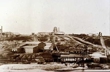 Clunes Museum
Photograph, C 1865
.1 PHOTOGRAPH - ORIGINAL SEPIA - OF PORT PHILLIP AND COLONIAL GOLD MINE, CLUNES, POPPET HEAD ON SKYLINE. .2 SEPIA PRINT OF PHOTOGRAPH .3 PHOTOCOPY OF A LITHOGRAPH OF THIS PHOTOGRAPH .4 BLACK AND WHITE COPY .5 MOUNTED BLACK AND WHITE COPY .6 BLACK AND WHITE COPY .7 BLACK AND WHITE COPY PORT PHILLIP AND COLONIAL MINING COMPANY, CLUNES. GENERAL VIEW, MINE AND WORKS. C. NETTLETON, PHOTO MELBOURNE.local history, photography, photographs, mining -
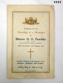 Bendigo Military Museum
Memorabilia - NURSE MEMORIAL, 1.5.1949
Matron (Major) Olive Dorothy PASCHKE No VX38812 enlisted in the AAMC on 3.8.40 age 35 years. Promoted to Matron 8.1.1941, posted to 10th AGH on 11.1.1941, embarked for Malaya 3.2.1941 disembarking 18.2.1941, awarded the RRC 1st Class 1.1.1942 in the New Years Honors list signed by Gordon Bennett, detached to 2/4th CCS on 6.1.1942, embarked from Singapore 12.2.1942 for Australia. She was serving in Singapore when the Japanese invaded. She with many other Nurses during the bombing left on the ill fated "Vyner Brooke" which was later bombed by the Japanese in the Sundra Straits near Banka Island. Abandoning the ship she and 5 other Nurses drifted away on a raft and never seen again on 14.2.42. Many others became POW,s, drowned or murdered by the Japanese. Her records state believed killed on or after 11.2.142 dated 8.6.1944 then Now reported missing and for official purposes presumed dead, dated 11.4.1945. Records state she was granted the promotion of Major in 1943. CCS (Casualty Clearing Station) RRC ( Royal Red Cross) AGH (Australian General Hospital)Five page "order of service" re the unveiling of a memorial to "Matron O.D. Paschke RRC AANS 10th Australian General hospital." at the Dimboola Memorial High school." A sepia tone photo of O.D Paschke is stapled inside the order of service." printing is in blue & Brown. Front page has the Australian coat of arms at the top.documents - pamphlets, religon - christian, paschke, pow -
Clunes Museum
Map - PLAN / MAP
.1 MAP, TOWN OF CLUNES, PARISH OF CLUNES, COUNTY OF TALBOT, STAMPED BOROUGH OF CLUNES .2 PLAN OF SUBDIVISION OF PART OF CLUNES COMMON, BOROUGH OF CLUNES, PARISH OF CLUNES,COUNTY OF TALBOT. P. CAMPBELL. ASSISTANT SURVEYOR, MARCH 1904 ON RIGHT HAND BOTTOM CORNER C71/1 CLUNES COMMON. MARKED: CHARTED R.L.A.7/2/57.1 PHOTO LITHOGRAPHED. DEPARTMENT OF LANDS AND SURVEY, MELBOURNE .2 PHOTO LITHOGRAPHED AT THE DEP. OF LANDS AND SURVEY, MELBOURNE PRICE 1/- 10.11.08map town of clunes, borough of clunes, parish of clunes, county of talbot -
 Whitehorse Historical Society Inc.
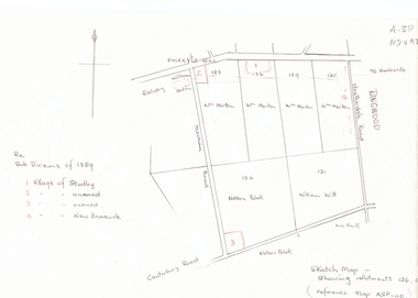
Document, Subdivisions 1859, nd
Sketch map of subdivisions of 1859.Sketch map of subdivisions of 1859. Allotment 126 and portions of 125, 126 and 130, including 'Village of Studley', 'Village of New Brunswick' and two unnamed. Information from Mr McComb, retired surveyor; sketch and notes. Areas near railway line east of Mitcham Station and North East corner of Canterbury and Mitcham Roads. Refer map A - SP 110.Sketch map of subdivisions of 1859.land subdivision, heatherdale road, mitcham, purches street, mitcham road, vermont, canterbury road, whitehorse road, brunswick road, creek road, centre road, studley village, new brunswick village -
 Bendigo Historical Society Inc.
Document - LAND AND SURVEY CIRCULARS 1876 - 1883, 1876 - 1883
Document: land and survey circulars - brown paper covered journal tied with string along spine. On front cover top LH corner '04A' Stuck to front cover is blue foolscap handwritten letter from Office of Lands and Survey (Occupation Branch) Melbourne 15th. March 1876. Journal contains copies of letters signed by District Surveyor, Sandhurst.Office of Lands and Surveyorganization, bendigo, sandhurst, land sales, land surveys -
University of Melbourne, Burnley Campus Archives
Plan, John S. Jenkins, Plan showing land required for Road Purposes from the temporary reservaton for Horticultural Gardens at Richmond, 1880
Plan drawn by hand on tracing paper by John S. Jenkins, Town Surveyor, Richmond. "The land required is coloured red & it is proposed to add the part of Swan Street coloured blue to the gardens." Plan depicts land required for road purposes from the temporary reservation for Horticultural Gardens at Richmond. (Also framed and glazed copy B92.0539.) Scanned on CD.john s. jenkins, gardens, richmond, hoticultural society of victoria -
 Warrnambool and District Historical Society Inc.
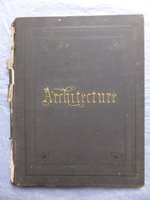
Book, Architecture, 1870s
This book belonged to John William Crawley an engineer, architect and surveyor who was appointed District Engineer for the Public Works Department in the Western District in 1866. He was the Shire of Warrnambool Engineer from 1874 to 1895 when he was succeeded by his son. This book is of minor importance as a memento of John William Crawley an important engineer in the Shire of WarrnamboolThis is a hard cover book with pages containing architectural plans,designs and printing. Some of the pages are blank.The cover is faded and spotted and has a gold title The spine is damaged .Inside the front cover is an inscription and on the following page is another inscription.J.W Crawley 1879 Architecture john william crawley, shire of warrnambool -
 Eltham District Historical Society Inc
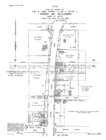
Document - Survey Plan, Country Roads Board, SP 6800, Eltham-Yarra Glen Road; Bridge St to Henry St, 1958
1958 C.R.B. Plan of Survey of Part of Crown Portions 12 and 13 Section 4 Parish of Nillumbik, County of Evelyn Eltham-Yarra Glen Road., Shire of Eltham Shows Surveyor field notes, property ownership and building type and construction.1958, a.m. gahan, a.s & s.j. davis, annie ellen davies, bridge street, country roads board, d.a. lyon, dave lyon, eltham, flora towell, g.e. gallagher, henry street, j. lyon, k. greene, main road, p.a. gahan, survey plan, w.l. chynoweth pty ltd, york street, neil webster collection -
 Kew Historical Society Inc
Plan - Subdivision Plan, Six Big Home Sites, Camberwell North, c.1936
Subdivision plans are historically important documents used as evidence of the growth of suburbs in Australia. They frequently provide information about when the land was sold on which a built structure was subsequently constructed as well as evidence relating to surveyors and real estate and financial agents. The numerous subdivision plans in the Kew Historical Society's collection represent working documents, ranging from the initial sketches made in planning a subdivision to printed plans on which auctioneers or agents listed the prices for which individual lots were sold. In a number of cases, the reverse of a subdivision plan in the collection includes a photograph of a house that was also for sale by the agent. These photographs provide significant heritage information relating house design and decoration, fencing and household gardens.A subdivision in what is currently Balwyn, but which was advertised as being in Camberwell North. The subdivision included six allotments facing Buchanan Avenue and Houghton Street. The subdivision was to the east of the Pointed Firs Estate (1936). In addition to the intrinsic value of this subdivision plan, it also reveals information about the development of transport infrastructure in this area. The subdivision plan notes that the Tramways Board has approved the extension of the tram route past the current terminus at Balwyn Road.subdivision plans - camberwell -
 Kew Historical Society Inc
Plan - Subdivision Plan, Windella-Darnley Subdivision, Studley Park, 1920s
Subdivision plans are historically important documents used as evidence of the growth of suburbs in Australia. They frequently provide information about when the land was sold on which a built structure was subsequently constructed as well as evidence relating to surveyors and real estate and financial agents. The numerous subdivision plans in the Kew Historical Society's collection represent working documents, ranging from the initial sketches made in planning a subdivision to printed plans on which auctioneers or agents listed the prices for which individual lots were sold. In a number of cases, the reverse of a subdivision plan in the collection includes a photograph of a house that was also for sale by the agent. These photographs provide significant heritage information relating house design and decoration, fencing and household gardens.Version 1 of two subdivision plans (the later one is MAP.0027) for the section of Studley Park Road near the Junction on the south side. Named in the subdivision are the mansions of Darley and Windella (now demolished). Before the subdivision of Darley and Windella, both houses fronted Studley Park Road. Both houses appear to be advertised as lots in the subdivision. Bisecting the subdivision is a street, Antrim Avenue that was never constructed. A street, which was subsequently constructed in this vicinity, was Merrion Place, which now runs between Studley Park Road and Highfield Grove. There are 14 proposed lots in this subdivision."Antrim Avenue. See over for new plan"subdivision plans - kew, studley park, windella, darnley, studley park road -- kew (vic.), merrion place -- kew (vic.), merrion grove -- kew (vic.), highbury grove -- kew (vic.) -
 Kew Historical Society Inc
Plan - Subdivision Plan, Shop Sites, East Kew, c.1927
Subdivision plans are historically important documents used as evidence of the growth of suburbs in Australia. They frequently provide information about when the land was sold on which a built structure was subsequently constructed as well as evidence relating to surveyors and real estate and financial agents. The numerous subdivision plans in the Kew Historical Society's collection represent working documents, ranging from the initial sketches made in planning a subdivision to printed plans on which auctioneers or agents listed the prices for which individual lots were sold. In a number of cases, the reverse of a subdivision plan in the collection includes a photograph of a house that was also for sale by the agent. These photographs provide significant heritage information relating house design and decoration, fencing and household gardens.This is one of a small number of subdivision plans for commercial property in the collection. The subdivision proposed to create six shop sites in High Street between the Harp of Erin and Station Street. The plan shows this stretch of High Street, East Kew already lined with shops that include the hotel on the corner, the new State Savings Bank, a dentist’s surgery and Lambert’s Store. The High Street Tram was to reach Burke Road in 1925, so the proposed subdivision must postdate that event, and the opening of the Bank in 1926.subdivision plans - east kew, high street - east kew -
 Kew Historical Society Inc
Plan - Subdivision Plan, Eastlawn Estate, 1914
Subdivision plans are historically important documents used as evidence of the growth of suburbs in Australia. They frequently provide information about when the land was sold on which a built structure was subsequently constructed as well as evidence relating to surveyors and real estate and financial agents. The numerous subdivision plans in the Kew Historical Society's collection represent working documents, ranging from the initial sketches made in planning a subdivision to printed plans on which auctioneers or agents listed the prices for which individual lots were sold. In a number of cases, the reverse of a subdivision plan in the collection includes a photograph of a house that was also for sale by the agent. These photographs provide significant heritage information relating house design and decoration, fencing and household gardens.The ‘Eastlawn Estate’ was surveyed and ready for auction in March 1914, three months before the outbreak of World War I. Sixty-six allotments, created on the ‘order of Mr & Miss Preston’ surrounded the mansion of Woodlands in Harp Road. Woodlands formed part of the Estate, being advertised as lot 1. The allotments faced High, Station and Wright Streets, Harp and Normanby Roads, and Woodlands Avenue. Pru Sanderson in the Kew Conservation Study (Vol.2, 1988) wrote that the Eastlawn Estate ‘covered the western half of the failed Harp of Erin Estate’. Contemporary advertisements promoted the Eastlawn Estate as: ‘There will be no more convenient district nor pleasant Suburb than East Kew for the busy business man. When the Electric Tram is laid, he will be able to journey quickly and pleasantly direct from Collins Street to his home in the Eastlawn Estate in about 20 minutes’. The actual plans of subdivision were included in advertisements in The Argus and in the local newspapers.subdivision plans - east kew, eastlawn estate -
 Kew Historical Society Inc
Plan - Subdivision Plan, Raheen Estate Subdivision, 1960
Subdivision plans are historically important documents used as evidence of the growth of suburbs in Australia. They frequently provide information about when the land was sold on which a built structure was subsequently constructed as well as evidence relating to surveyors and real estate and financial agents. The numerous subdivision plans in the Kew Historical Society's collection represent working documents, ranging from the initial sketches made in planning a subdivision to printed plans on which auctioneers or agents listed the prices for which individual lots were sold. In a number of cases, the reverse of a subdivision plan in the collection includes a photograph of a house that was also for sale by the agent. These photographs provide significant heritage information relating house design and decoration, fencing and household gardens.The Raheen Estate Subdivision of 1960 involved the creation of 36 residential allotments and the sale of 34 of these. The land on which the subdivision was created had until 1960 formed part of the grounds of the mansion Raheen in Studley Park Road. In 1917, the Catholic Church had purchased Raheen and its lands. It was to become the home of Archbishop of Melbourne, Daniel Mannix, for 46 years. The sale of the subdivision took place three years before the Archbishop’s death. Subsequent archbishops were to reside at Raheen until its sale to the Pratt family in 1981. When the sale of the Estate was reported in the newspapers in 1960, it was described as the last big subdivision near Melbourne. At the auction, 33 of the 36 allotments were sold. The auction realised £315,750. Purchasers were advised that the vendor intended to keep lots 22 and 23. The alllotments in the subdivision required the construction of new roads. These included Eamon Court and Raheen Drive. The justification provided by the Church for the sale was that the estate was being sold to finance school building projects.subdivision plans - kew, studley park, raheen estate, eamon court, studley park road, coombes avenue, raheen drive -
 Kew Historical Society Inc
Photograph, Standard Newspapers, Charles Grimes Re-enactment, Yarra River, 1978
The party of the British surveyor Charles Grimes were the first Europeans to view the River Yarra, as it was later to be named. Members of the party reached the area now known as Studley Park in 1803. This local re-enactment commemorated 175 years since that event. Charles Grimes Re-Enactment, Yarra River, Kew, 1978. The photograph is of a student of Trinity Grammar School and the Mayor of Kew, Cr. Whiting. Inscription on reverse: "KH-161. Society's contribution to the 1978 Festival of Kew. Re-enactment of first white man's journey and discovery of the Yarra River and the area now know (sic) as Kew. 1978. This was in the year 1903 when Grimes and party came upon the Yarra to seek a possible site for a new convict settlement. Cr. Whiting, Mayor of Kew, receiving the report from Grimes, 'Andrew Allen'. Cr. Hutchinson in top hat 'town cryer'. Bush band in backround." Ripped stamp on reverse: "Standard N[ewspapers]."charles grimes re-enactment, trinity grammar school, cr whiting -- mayors -- kew (vic.), yarra river, andrew allen, kew historical society -
 Kew Historical Society Inc
Photograph, Standard Newspapers, Charles Grimes Re-enactment, Yarra River, 1978
The party of the British surveyor Charles Grimes were the first Europeans to view the River Yarra, as it was later to be named. Members of the party reached the area now known as Studley Park in 1803. This local re-enactment commemorated 175 years since that event.Charles Grimes, Re-enactment, Yarra River, Kew, 1978. Inscription on reverse: "Trinity Grammar School students taking part in Grimes' journey up the Yarra, 1803. Re-enactment Historical Society Kew contribution to the 1978 Festival of Kew."charles grimes re-enactment, trinity grammar school, cr whiting -- mayors -- kew (vic.), yarra river, andrew allen, kew historical society -
 Kew Historical Society Inc
Photograph, Standard Newspapers, Charles Grimes Re-enactment, Yarra River, 1978
The party of the British surveyor Charles Grimes were the first Europeans to view the River Yarra, as it was later to be named. Members of the party reached the area now known as Studley Park in 1803. This local re-enactment commemorated 175 years since that event.Charles Grimes, Re-enactment, Yarra River, Kew, 1978. Inscription on reverse: "KH-191. Grimes' party in boat on Yarra 1978. Re-enactment organised by Kew Historical Society. Actors Trinity Grammar boys. Mrs Argyle's History class." Sticker on back: "771. Standard News. WHS. Festival. 4 cols. May 3. [Page] 5."charles grimes re-enactment, yarra river (kew) 1978, cr whiting (mayor of kew), andrew allen, trinity grammar school, kew historical society -
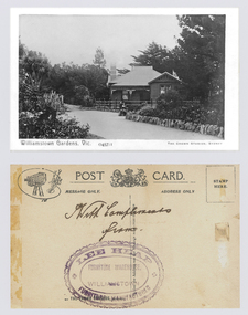 Williamstown Botanic Gardens- Hobsons Bay City Council
Postcard – Williamstown Botanic Gardens, The Crown Studios, Sydney, c1900-1920
The Curator’s lodge, designed by the Town Surveyor, HV Champion, was constructed in 1907 following the re-organisation of the north-east corner with the demolition of the old curator's cottage and erection of new gates. Lee Heap Furniture Warehouse of Williamstown used the postcards to advertise. The postcards are evidence of the interest the gardens held as a subject for postcard publishers. The text and images provide a snapshot into fashions, social interests and concerns of the time. The professionally produced images provide a pictorial history of Gardens including changing planting styles, various structures and features of the Gardens eg the aviary, cannons, the fountain, the second Curator’s Lodge and gates. The images offer an opportunity to compare garden vistas with the present day.A sepia image looking across a path bordered with rocks of a house (the Curators lodge) behind a fence. In front of the fence there is a young girl sitting on a rock with a young boy standing beside her. The house is timber with two brick chimneys, the right hand one half hidden by foliage. The house is federation style with timber battening above the front window. A timber frieze is above a verandah supported by three posts and light coloured brackets. Front: ‘Williamstown Gardens. Vic.’ ‘0457/1’ THE CROWN STUDIOS, SYDNEY’. Reverse: Centre top ‘POST CARD’ with a logo in the middle of the words. Left top corner a drawing of an artist’s board and brushes with a camera in the centre. Left side ‘MESSAGE ONLY.’ Right side ‘ADDRESS ONLY.’ Top right corner inside a dotted rectangle ‘STAMP HERE’. Bottom on card ‘BY THE CROWN STUDIOS, SYNDEY.’ Under the vertical line down the middle line ‘Neither the Address not the Message must cross this line’. In ink ‘With Compliments / from’. An oval stamp with scalloped rim ‘LEE HEAP FURNITURE MANUFACTURER’ inside inner oval ‘FURNITURE WAREHOUSE, / WILLIAMSTOWN’.postcard, gardens, post-card, williamstown-botanic-gardens, hobsons-bay-city-council, curator’s lodge, children, federation style, crown studios, lee heap furniture warehouse -
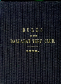 Federation University Historical Collection
Book, Ballarat Turf Club, Rules of the Ballarat Turf Club 1870, 1872 (estimated); The publishing date is given as 1870 but refrence is made to 1872 amendments
Small Brown/maroon booklet of 24 pages. Includes constitution, subscription, membership, rules of horse racing in general, standard weights for age, weighing, starting, heats, foul riding, nominations, disqualifications, stakes, forfeits, betting, scratching and amendments and additions made to the rules of the Ballarat Turf club approved at a special general meeting held at Craig's Royal hotel on 9 October 1872Ammended rules have been crossed out in red ink ballarat turf club, horse racing, sport of kings,