Showing 11366 items matching "land-clearing"
-
 Kew Historical Society Inc
Plan, Sydney Arnold Best & Co, Field Place, Kew, c.1929
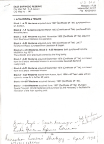
Pru Sanderson, in her groundbreaking ‘City of Kew Urban Conservation Study : Volume 2 - Development History’ (1988), summarised the periods of urban development and subdivisions of land in Kew. The periods that she identified included 1845-1880, 1880-1893, 1893-1921, 1921-1933, 1933-1943, and Post-War Development. These periods were selected as they represented periods of rapid growth or decline in urban development. An obvious starting point for Sanderson’s groupings involved population growth and the associated economic cycles. These cycles also highlighted urban expansion onto land that was predominantly rural, although in other cases it represented the decline and breakup of large estates. A number of the plans in the Kew Historical Society’s collection can also be found in other collections, such as those of the State Library of Victoria and the Boroondara Library Service. A number are however unique to the collection.The Kew Historical Society collection includes almost 100 subdivision plans pertaining to suburbs of the City of Melbourne. Most of these are of Kew, Kew East or Studley Park, although a smaller number are plans of Camberwell, Deepdene, Balwyn and Hawthorn. It is believed that the majority of the plans were gifted to the Society by persons connected with the real estate firm - J. R. Mathers and McMillan, 136 Cotham Road, Kew. The Plans in the collection are rarely in pristine form, being working plans on which the agent would write notes and record lots sold and the prices of these. The subdivision plans are historically significant examples of the growth of urban Melbourne from the beginning of the 20th Century up until the 1980s. A number of the plans are double-sided and often include a photograph on the reverse. A number of the latter are by noted photographers such as J.E. Barnes.An unnamed subdivision in Studley Park including five lots for sale in Studley Park Road, Highfield Grove and Tara Avenue. Unidentified on the plan, but clearly existing, are the Henty family mansion of Field Place and Tara Hall in Studley Park Road. The first attempted subdivision of Tara Hall was advertised in 1927 in which Lots 5, 6 and 7 in this plan were also advertised. Unusually, Lot 2 in Studley Park Road was created from the northern part of the Henty mansion, rather than Tara Hall. In the subdivision, lots were advertised at varying prices, with the highest price for land being Lot 2 in Studley Park Road. The plan notes that only one villa is to be allowed on each allotment.subdivision plans - kew, field place subdivision -- studley park – kew (vic.), highfield grove – kew (vic.), tara avenue – kew (vic.) -
 Stratford and District Historical Society
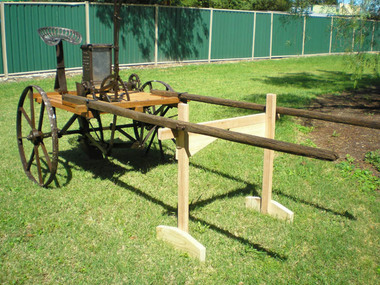
Poison Cart
Cart was operated by the Briagolong Rabbit Suppression League. It was purchased by the donor at the clearing sale for Jim Kelly in the late 1980s/early 1990s. Jim was the son of the main organiser of the Briagolong Rabbit Suppression League. Copies of the Minutes and accounts have been obtained, and are catalogued separately. Wood on cart was in much degraded condition, whole cart repaired by George Parker of the Stratford and District Historical Society, 2010.Rabbit poison cart by T.H. Hicks of Sydney. Consists of wooden frame and floor 80cm high, wheels with cast iron hubs. Chain-driven from one wheel, operator's seat at rear, with a lever mechanism to control the trench forming attachment. Horse shafts 2.6 metres long. Serial number is cast in one side of the bait bin, and not on the other."Ideal" / T.H. Hicks / Patentee / Nth Botany No 5102 / N.S.W.rabbits, vermin destruction -
 Warrnambool and District Historical Society Inc.
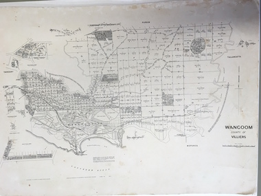
Document: Map, Map Wangoom County of Villiers, 1955
This map contains the names, acreage details and dates of the original property owners of the Parish of Wangoom (County of Villiers), excluding the township of Warrnambool. It also has details of the Crown Lands adjoining the Merri and Hopkins Rivers. This is a most important map as it has details on the original property owners. It is a most valuable research tool and is one of our most-used maps.This is a map, printed in black and white and mounted on cardboard. Where there was intensive land ownership the details have been reproduced in larger print on the margins of the map. There are scuff and dirt marks on the map but it is otherwise in good condition.‘Wangoom, County of Villiers’wangoom, warrnambool, county of villiers -
 Glenelg Shire Council Cultural Collection
Photograph - Photograph - aerial view of Portland coastline, c. 1954
Black and white aerial photograph of coastline around Portland. Black border, scale all sides, 5 rows of 3 't' at regular intervals. 10% ocean, 90% land. See 'Other Information'Front: '820- 52' - handwritten, white, border 'RUN 6' 'PORTLAND', printed, white, borderport of portland, aerial photography, south west coastline -
Glenelg Shire Council Cultural Collection
Photograph - Photograph - aerial view of Portland, c. 1954
Black and white aerial photograph of coastline around Portland. Black border, scale all sides, 5 rows of 3 't' at regular intervals. 25% ocean, 75% land. See 'Other Information'Front: '820 - 50' - handwritten, white, border 'RUN 6' 'PORTLAND', printed, white, borderaerial photography, central portland, portland harbour, south west coastline -
Glenelg Shire Council Cultural Collection
Photograph - Photograph - aerial view of Portland, c. 1954
Black and white aerial photograph of coastline around Portland. Black border, scale all sides, 5 rows of 3 't' at regular intervals. Mostly ocean, small area of land lower left.Front: '820-6' -- handwritten, white, lower border 'RUN 5' 'PORTLAND', printed, white, lower borderaerial photography, central portland, portland harbour, south west coastline -
Glenelg Shire Council Cultural Collection
Photograph - Photograph - Aerial photograph of coastline around Portland, Victoria, c. 1954
Black and white aerial photograph of coastline around Portland. Black border, scale all sides, 5 rows of 3 't' at regular intervals. Bottom 20% ocean, rest land, separated by beach.Front: '607 - 88' - handwritten, white, border 'RUN - 6 PORTLAND', printed, white, border -
Glenelg Shire Council Cultural Collection
Photograph - Photograph - aerial view of Portland, c. 1954
Black and white aerial photograph of coastline around Portland. Black border, scale all sides, 5 rows of 3 't' at regular intervals. Mostly ocean, small area of land, top left.Front: '607 - 49 ' - handwritten, white, border 'RUN 8' 'PORTLAND', printed, white, borderaerial photography, central portland, portland harbour, south west coastline -
Glenelg Shire Council Cultural Collection
Photograph - Photograph - aerial view of Portland, c. 1954
Black and white aerial photograph of coastline around Portland. Black border, scale all sides, 5 rows of 3 't' at regular intervals. Mostly ocean, small area of land, top centreFront: '607 - 50 ' - handwritten, white, border 'RUN 8' 'PORTLAND', printed, white, borderaerial photography, central portland, portland harbour, south west coastline -
Glenelg Shire Council Cultural Collection
Photograph - Photograph - aerial view of Portland, c. 1954
Black and white aerial photograph of coastline around Portland. Black border, scale all sides, 5 rows of 3 't' at regular intervals. Bottom third is ocean, the rest is land, separated by beach.Front: '607 - 89 ' - handwritten, white, border 'RUN - 6 PORTLAND', printed, white, borderaerial photography, central portland, portland harbour, south west coastline -
Glenelg Shire Council Cultural Collection
Photograph - Photograph - aerial view of Portland, c. 1954
Black and white aerial photograph of coastline around Portland. Black border, scale all sides, 5 rows of 3 't' at regular intervals. Bottom half ocean, top land, separated by beach.Front: '607 - 92 ' - handwritten, white, border 'RUN - 6 PORTLAND', printed, white, borderaerial photography, central portland, portland harbour, south west coastline -
Glenelg Shire Council Cultural Collection
Photograph - Photograph - aerial view of Portland, c. 1954
Black and white aerial photograph of coastline around Portland. Black border, scale all sides, 5 rows of 3 't' at regular intervals. Small strip of land across bottom. The rest is ocean.Front: '607 - 56 ' - handwritten, white, border 'RUN 7 PORTLAND', printed, white, borderaerial photography, central portland, portland harbour, south west coastline -
 Halls Gap & Grampians Historical Society
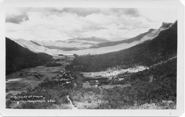
Postcard - B/W
Photo on card was taken by Gilbert Rogers, a photographer and tour guide during the 1930s. This postcard is one of a series.Depicts as valley with mountains on both sides. Cleared land can be seen on either side of a road which runs through the valley. Buildings are also visible in middle area. View is running south-west.scenery, fyans valley -
 Federation University Historical Collection
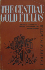
Book, Harley W. Forster, The Central Goldfields, 1969
Brown covered book of 80 pages. Topics include gold, McIvor diggings, Tarrangower goldfields, Maldon, quartz reefs, Chinese, land selection, Mt Alexander, Castlemaine, gold licence agitation, glossary. gold license, gold licence, castlemaine, goldfield agitation -
Federation University Historical Collection
Exercise Book, William Baragwanath, William Baragwanath's Exercise Book, 1898, 1898
William Baragwanath studied at the Ballarat School of Mines, obtained a Geology certificate in 1911. He was born on 01 August 1878 at Ballarat. He joined the Victorian Department of Mines in 1897 and was Chief Mining Surveyor from 1924 to 1943. Baragwanath died at Prahran on 20 Septemeber 1966.Marbled blue card covered exercise book with yellow tape spine containing handwritten notes by William Baragwanath on dividing land problems, earthworks, refraction, etc; Headings include: Tom Joe Smith ballarat school of mines, earthworks, land problems, refraction, william baragwanath, -
Glenelg Shire Council Cultural Collection
Photograph - Photograph - Main Breakwater construction, Portland, n.d
Port of Portland Authority Archivesport of portland archives, main breakwater, construction, portland, harbour, harbour development -
 Bendigo Historical Society Inc.
Book - ERROL BOVAIRD COLLECTION: NEW SETTLERS' HANDBOOK TO VICTORIA
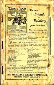
Book titled 'New Settlers' Handbook to Victoria. Book contains information of the State of Victoria, Welcoming the New Australian, The Farm Learner, Settling on the Land, The Settler's Home, The 'N.S.L.' Districts and a Buyers' and Sellers' Directory.New Settlers League of Australia3john bovaird collection - new settlers' handbook to victoria, the herald & weekly times ltd, the honorable john allan mla, new settlers league of australia (victorian division), archibald gilchrist -
 Bendigo Historical Society Inc.
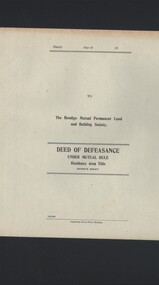
Document - CURNOW COLLECTION: FORM DEED OF DEFEASANCE, 19??
'Deed of Defeasance under Mutual Rule . Residence Area Title (Miner's Right). The Bendigo Mutual Permanent Land and Building Society. Four page blank (unused) form. Printer: Cambridge Press Print.Cambridge Press Printperson, individual, curnow collection -
Port Melbourne Historical & Preservation Society
Document - Correspondence re purchase of land by Port Melbourne Council for new Electricity Supply Depot, City of Port Melbourne, 1976
Correspondence etc concerning PMCC's attempt to purchase land for a new Electricity Supply depot in 1976. This paperwork was retained by the City Valuer, Mr Frank Julier, who served in that post from around 1974local government - city of port melbourne, built environment, f l julier - city valuer -
Port Melbourne Historical & Preservation Society
Document - SCDC Report, Ewan Ogilvy's Bayside Papers Box One, 1987 - 1998
Ewan Ogilvy, former Melbourne Councillor and also of Community Services Victoria, Inner Urban Ministerial Advisory Committee and Uniting Church's Centre for Urban Research and Action (CURA), was instrumental in social justice approaches to town planning. He and CURA's Social Justice and the City Project funded Port Melbourne community groups protesting against the SCDC development in 1987. His files were presented to the Society in May 2001 on his preparation for leaving Victoria.From Ewan Ogilvy's chronologically organised 'Bayside Papers' relating to the proposed development of Port Melbourne industrial land in the late 1980s: Extra photocopies of all documents in 1390.06, bound only with bulldog clipAll items signed 'Ewan Ogilvy'town planning, town planning - proposals shelved - bayside, public action campaigns, environmental issues, public housing, ewan ogilvy, centre for urban research and action, sandridge city development co pty ltd, scdc, tom roper, evan walker -
Port Melbourne Historical & Preservation Society
Document - Vendors Statement for the sale of Lot 35 Beacon Cove, Port Melbourne, 1996
Lot 35 is now titled 18 Park Square, Beacon Cove, Port MelbourneFolder with pale green cover and black spiral binding. Folder contains Vendors Statement to the Purchaser of Real Estate pursuant to Section 32 of the Sale of Land Act 1962 for Lot 35 Beacon Cove.built environment - domestic, department of planning and development, park square, beacon cove, mirvac -
Clunes Museum
Document - DOCUMENTS
.1 DATED 12/05/1926 ACCOUNT FOR FUNERAL ARRANGEMENTS FOR HARRIET RICHARDS FROM W BARKELL UNDERTAKER .2 COPY OF TITLE OF LAND SITUATED SMEATON RD., CLUNES FOR JAMES WILLIAMS OF SMEATONw. barkell, harriet richards, james williams of smeaton -
Tatura Irrigation & Wartime Camps Museum
Book, Department of Agriculture Victoria, Institute for Sustainable Agriculture, 1993
Investigation of salinity problems by staff at Tatura, Kyabram, Shepparton, and Cobram Institutes.Department of Agriculture photos on front. Saline waterlogged land near Shepparton. Measuring white clover growth. Salinity management plans for research. Farm planning blueprint. Satellite image of plains and Lodden river.salinity, department of agriculture, kyabram, tatura, shepparton, cobram -
Clunes Museum
Newspaper - NEWSPAPER CUTTING, AUSTRALIA POST PUBLICATIONS, 1986
NEWSPAPER CUTTING REPORTING THE CONFUSION AT CLUNES BETWEEN LAND DEVELOPER AND TALBOT CLUNES SHIRE COUNCIL. 11/9/1986 RE DEVELOPMENT McLENNANS ROAD. REPORTER BOB O'BRIEN - PHOTOGRAPHER PAUL O'BRIEN.local history, document, newspaper cutting, clunes land development -
 Whitehorse Historical Society Inc.
Document, Mrs Daisy Matthews, 30/12/1927
A photocopy of letter from L.V. Higgins, solicitor of Geelong to Jones, Morton & Son re land valuation of property belonging to Mrs Daisy Matthews in Main Street Blackburn, 30 December 1927 and reply.land values, matthews, daisy, main street, blackburn -
 Whitehorse Historical Society Inc.
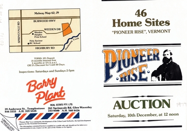
Document, Pioneer Rise, ca 1977
Brochure advertising auction of 'Pioneer Rise',Brochure advertising auction of 'Pioneer Rise', Vermont South. 46 sites offered by the Urban Land Authority 10 December 1977?. Agent Barry Plant Real Estate Pty Ltd. Colour photos.Brochure advertising auction of 'Pioneer Rise', auctions, vermont south, pioneer rise, pioneer close, sewart close, mont court, victoria. urban land authority -
 Whitehorse Historical Society Inc.
Letter - Correspondence, East Burwood Reserve, 1993
Various documents relating to the establishment of East Burwood ReserveVarious documents relating to the establishment of East Burwood Reserve including acquisition of land, details, plans, locality map, news cuttings and photographs. Appears to be copy of Nunawading City Council File April 1993Various documents relating to the establishment of East Burwood Reserve sportsgrounds, east burwood reserve, soilleur (dr), hitchens, anna, blue moon fruit co-operative ltd., jacobson and logan, king family, central methodist mission, aussat, tally ho, sewart, bill -
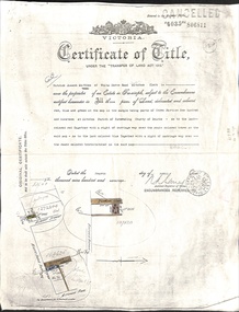 Whitehorse Historical Society Inc.
Document - Land Title, Certificate of Title, 4/04/1917
Certificate of Title of three blocks of land owned by Patrick Joseph Markham in Deakin Street, Albert Street and Britannia Street, Mitcham dated 4 April 1917 and records of sales of the blocks up to 1926.deakin street, mitcham, albert street, britannia street, markham, patrick joseph, dodsworth, george, smith, lily maud, hunt, james charles, land sales -
Whitehorse Historical Society Inc.
Document, Memorandum of Association, 1913
Memorandum of Association of the Commonwealth Art Pottery and Insulator Company Proprietary Limited, 1913.Memorandum of Association of the Commonwealth Art Pottery and Insulator Company Proprietary Limited, 1913. Mentions 2 original shareholders and price paid for land ( Springfield Road, Blackburn and Croydon Road, Ringwood), plant and machinery.Memorandum of Association of the Commonwealth Art Pottery and Insulator Company Proprietary Limited, 1913. commonwealth pottery pty ltd, springfield road, blackburn north, levy, henry wolff, staughton, robert allen -
Whitehorse Historical Society Inc.
Postcard - Illustration, Heidelberg School
Folio of coloured postcards of artists paintings from the Heidelberg School. The Heidelberg School set up tents in 1885 on land belonging to David Houston on Gardiner's Creek. Included is a history on each artist and painting.heidelberg school, davies, david, conder, charles, phillips, fox emanuel, mccubbin, frederick, roberts, tom, streeton, arthur, sutherland, jane, withers, walter, alston, alby, box hill artists camp