Showing 10532 items
matching land
-
 Bendigo Historical Society Inc.
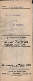
Document - H.A. & S.R. WILKINSON COLLECTION: CONDITION OF SALE
Conditions of sale by private contract dated 27th May, 1927 between G. J. Wilkinson and I. H. Herrick for land at corner Buckley and Reviere Streets, Bendigo certificate of registration 30313 together with 5-roomed weatherboard and german brick dwelling for the price of 235 pounds.organization, business, h.a. & s.r wilkinson real estate -
 Bendigo Historical Society Inc.
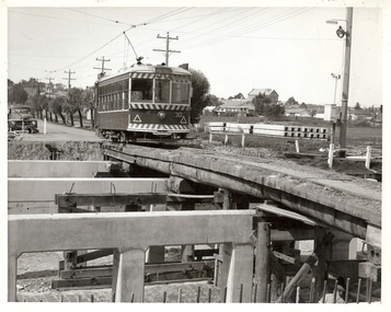
Photograph - BASIL MILLER COLLECTION: NO 30 TRAM
Black and white photo of No 30 Birney Car crossing the Nolan Street Bridge which is under going reconstruction. Vacant land on right of photo is now occupied by the Bendigo Tennis Complex..Written on back in pen '5 1/2'' x 5'' page 69 52.5 %'.person, individual, basil miller -
 Bendigo Historical Society Inc.
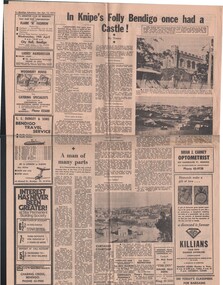
Document - BASIL MILLER COLLECTION: TRAMS AND KNIPE'S CASTLE/FOLLY'
Newspaper clipping, Bendigo Advertiser, Saturday April 15, 1972.'In Knipe's Folly Bendigo once had a castle', by Toora, (alias Amy Huxtable). John Hanlon Knipe bought land from W. E. Walleston, located in Boundary Street, (now known as Valentine Street).person, individual, basil miller -
 Bendigo Historical Society Inc.
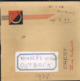
Newspaper - LYDIA CHANCELLOR COLLECTION: WONDERS OF THE OUTBACK
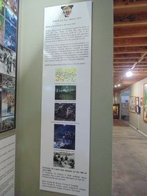
A handkerchief box containing newspaper cuttings from 'The Sun-News Pictorial' dated 1938, 'Wonders Of The Outback' on the beauty of and life in the outback. A series numbered 1 to 83. these clips contain photos and descriptions of Aboriginal/Indigenous People, Flora, Fauna, Lizards, Insects, land formations etc.Wonders of the outback 1938. 25 + 26 missing. Up to 83sciences, general, flora and fauna, lydia chancellor, collection, australian outback, outback, australian wildlife, wildlife, australian aborigines, aborigines, australian birds, birds, australian rock carvings, rock carvings, australian deserts, deserts, aboriginal, place, sciences, region, australia, plants, flora, fauna -
 Port Melbourne Historical & Preservation Society
Document - Report, Ewan Ogilvy's Bayside Papers, Executive Summary Bayside EES Inquiry, Ewan Ogilvy's Bayside Papers, Box One, 1988
Ewan Ogilvy, former Melbourne Councillor and also of Community Services Victoria, Inner Urban Ministerial Advisory Committee and Uniting Church's Centre for Urban Research and Action (CURA), was instrumental in social justice approaches to town planning. He and CURA's Social Justice and the City Project funded Port Melbourne community groups protesting against the SCDC development in 1987. His files were presented to the Society in May 2001 on his preparation for leaving Victoria.From Ewan Ogilvy's chronologically organised 'Bayside Papers' relating to the proposed development of Port Melbourne industrial land in the late 1980s: Executive summary of panel report, signed by panel for EES Inquiry 1997/8, included in bound black file (also contains Appendices to the enquiry)All items signed 'Ewan Ogilvy'town planning, town planning - proposals shelved - bayside, public action campaigns, environmental issues, public housing, ewan ogilvy, centre for urban research and action, sandridge city development co pty ltd, scdc, linton r lethlean, judy arndt, francis b barnes -
Port Melbourne Historical & Preservation Society
Poster - Public Transport Victoria, stylised view of Bay Street, Port Melbourne, Public Transport Victoria, 2017
Art deco style representation of Bay Street Port Melbourne with palm trees, bus and Mediterranean looking buildings. yachts in the Bay and moon rising behind land. Reverse side pale blue with text (Charles Rennie Macintosh style font) Same image as postcard 3992.01"Take a stroll under the palms of Port Melbourne. Explore the world of Melbourne by bus."built environment, bay street, public transport victoria -
Port Melbourne Historical & Preservation Society
Archive - File, Bayside Project Bill, Ewan Ogilvy's Bayside Papers, Box Three, 1987
Ewan Ogilvy, former Melbourne Councillor and also of Community Services Victoria, Inner Urban Ministerial Advisory Committee and Uniting Church's Centre for Urban Research and Action (CURA), was instrumental in social justice approaches to town planning. He and CURA's Social Justice and the City Project funded Port Melbourne community groups protesting against the SCDC development in 1987. His files were presented to the Society in May 2001 on his preparation for leaving Victoria.From Ewan Ogilvy's chronologically organised 'Bayside Papers' relating to the proposed development of Port Melbourne industrial land in the late 1980s: Bayside Project Bill documents including VP Hansard, copy of Act and of memorandum (a and b) plus related correspondence and documents, bound in clear fileSigned 'Ewan Ogilvy'town planning, town planning - proposals shelved - bayside, public action campaigns, environmental issues, public housing, missions to seamen, ewan ogilvy, centre for urban research and action, sandridge city development co pty ltd, scdc, linton r lethlean, barry pullen - mlc -
 National Vietnam Veterans Museum (NVVM)
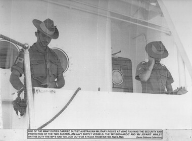
Photograph, Naval Supply Vessel Security
A black and white photograph - One of the many duties carried out by the Australian Military Police at Vung Tau was the security and protection of the two Australian Naval Supply vessels, The MV Boonaroo & MV Jeparit, whilst on this duty the MP's had to look out for attack from water and land.photograph, vung tau, military police, supply ship, hmas boonaroo, hmas jeparit, gibbons collection catalogue, australian naval supply vessels -
Whitehorse Historical Society Inc.
Article, Club saddles-up to move, 1993
Nunawading Pony Club is forced to re-locate outside the city to make way for a housing development.Nunawading Pony Club is forced to re-locate outside the city to make way for a housing development. Mayor, Kevin Abbott said the council cannot afford to purchase the land to allow the club to stay in Blackburn. Council has agreed to consider assisting the club with some money for relocation.Nunawading Pony Club is forced to re-locate outside the city to make way for a housing development. horse-riding, nunawading pony club, abbott, kevin -
 Whitehorse Historical Society Inc.
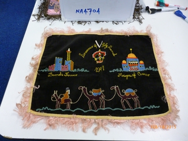
Domestic object - Cushion Cover, 1940s
Item donated by RWT Rowlands and was sent to wife of a friend serving in 2/7th Battalion A.I.F.Black Velvet Cushion Cover 42 x 31 with coloured embroidered designs of David Tower, Mosque of Oman; a row of five camels, across the bottom, and the words Souvenir of the Holy Land, across the top and around the edges a hem with gold coloured fringe and a white cotton backing.military history, army -
 Lakes Entrance Regional Historical Society (operating as Lakes Entrance History Centre & Museum)
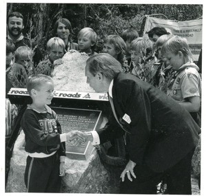
Photograph, 1991
This photo appeared in the L P Newspaper 13 November 1991Black and white photograph taken at the celebration to open the new concrete Princes Highway bridge over Toorloo Arm. Plaque unveiled by Minister for Land Transport, Bob Brown, seen greeting the youngest member of the community, Toorloo Arm Sea Scouts in attendance. Toorloo Arm Victoriabridges, waterways, animals -
 Bendigo Historical Society Inc.
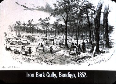
Slide - DIGGERS & MINING: THE DIGGINGS - THE DIGGERS
Diggers & Mining: The Digging - The Diggers. Slide depicts: Iron Bark Gully, Bendigo, 1852. Shows tents a woman with child, miners and diggings. Most of the land has been cleared, but some trees still remain. Markings: 20 994.LIF:6. Used as a teaching aid.Hanimounteducation, tertiary, goldfields -
City of Kingston
Photograph - Black and white, 20 December 1945
This aerial image covers a section of Cheltenham, with a large paddock yet to be converted to an industrial and later a commercial zone.This aerial photograph provides evidence of the changing landscape of Cheltenham and Highett since WWII. Photographed in 1945, the image features a large block of land now the site of site the major transformation of Cheltenham with the development of the Southland shopping centre in the 1960s and expansion in the 1990s.Aerial photograph of the Cheltenham area in the City of Kingston. This 1945 image is concentrated on the area between Bay Road and Garfield Lane with the distinctive bend into Jean Street. A large block of land runs between the Nepean Highway and the rail line. This is now the area occupied by the extension of Southland in the 1990s.cheltenham, southland, aerial photograph, highett -
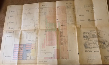 Melbourne Tram Museum
Drawing, Melbourne & Metropolitan Tramways Board (MMTB), "Footscray Depot - Layout Plan - Scheme II", 23/03/1960 12:00:00 AM
Drawings - coloured - titled "Footscray Depot - Layout Plan - Scheme II", signed by D. H. Eakins on 23-3-1960 showing a proposed layout of the depot following the closure of the Footscray system and the use of the entire block of land for buses. Has drawings of the Traffic Office and Amenities.trams, tramways, footscray, buses, depots -
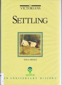 Greensborough Historical Society
Book, Settling: The Victorians. By Tony Dingle, 1984_
Part 2 of a 3-part series deals with land use from Aboriginal land use to European settlement.Published to commemorate the 150th anniversary of European settlement in Victoria.Hard cover. 274 pages, illus., maps, end maps.victoria land use, victoria history, victoria social conditions, tony dingle -
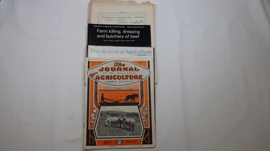 Kiewa Valley Historical Society
Journals - Department of Agriculture, 1. 1950s and 2. one 1932 & others 1970s
The Kiewa Valley has been a farming district from early settlement of white people. This has continued until the present although the nature of farming has varied over the years. Access to information has improved with transport and technology. The journals kept the farmers informed and up to date.These booklets and journals were one of the few sources of information during the 1950s for the isolated farmers of the Kiewa Valley. The Kiewa Hydro Electric Scheme improved both transport and technology during the scheme's construction from the 1940s. It provided the township of Mt Beauty at the upper end of the valley where shops and schools were constructed, roads were improved out of the valley and the supply of electricity for milking etc. became available. 1. 14 articles each bounded by 2 staples, and each reprinted from Dept. of Agriculture Journal on a particular topic relating to Agriculture. All black & white and c1950s. 2. 4 Journals with colored covers 3 from Victoria Dept. of Agriculture (1932, 1974 & 1975) and 1 from Sth. Australia.1. "J.H.Wallace" hand written top right corner of covers of pamphlets titled 'Diseases Affecting /Young Cattle' and 'Mastitis'. "AHW" hand written top right corner of cover of pamphlet titled ' Grading Land for Irrigation' 2. Nonefarming, agriculture, cattle, pasture, kiewa valley, department of agriculture in victoria, kiewa hydro electric scheme, -
 Kew Historical Society Inc
Plan - Subdivision Plan, J R Mathers & McMillan, Normanby Estate, c.1913
The Kew Historical Society's map collection includes a substantial number of real estate subdivision plans, mainly of Kew but also of surrounding suburbs in Melbourne. Most of the subdivision plans date from the 1920s and 1930s when the districts old homes and local farmland were being split up to accommodate residential growth in the postwar period. These early plans were assembled by a local firm, Jas R Mather & McMillan, which had an office in Cotham Road. Many of the plans, and sometimes photos, were annotated by the agents.Subdivision plans are historically important documents used as evidence for the growth of suburbs in Australia. They frequently provide information about when the land was sold as well as evidence relating to surveyors and real estate and financial agents. The numerous subdivision plans in the Kew Historical Society's collection represent working documents, ranging from the initial sketches made in planning a subdivision to printed plans on which auctioneers or agents listed the prices for which individual lots were sold. In a number of cases, the reverse of a subdivision plan in the collection includes a photograph of a house that was also for sale by the agent. These photographs provide significant heritage information relating house design and decoration, fencing and household gardens.The photograph may also be aesthetically significant depending on the importance of the photographic atelier.The Normanby Estate, which was adjacent to Normanby Road, Kew East, included thirty-one lots for sale. Streets on the subdivision plan include Adeney Avenue, Park Hill Road, Normanby Road, Weir Street and Wharton Street. Cotham Road and its tramway are shown nearby. The plan is interesting as it shows Wharton Street, named after the architect and town planner George Wharton, who was the first chairman of the Municipality of Kew. The street was to later be renamed Cecil Street. Also shown are proposed ‘Municipal Gardens’ where Parkhill Drive is now located."D" in top left corner. Stamped auctioneers contact details: "Jas. R. Mathers & Son & McMillan / Auctioneer & Land Salesmen, / 271 Collins Street / Melbourne" and Jas. R. Mathers / Estate & Financial Agent / Cotham Road / Kew".weir street - kew, wharton street - kew, normanby road - kew, cotham road - kew, municipal gardens - kew, park hill parkhill road - kew, braemar - kew, subdivision plans - kew -
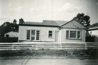 Ringwood and District Historical Society
Photograph, House at 28 Georges Road, Ringwood circa 1950s
Photos donated by Dawn Jones. Her in-laws Cath & Len Jones built the house on land subdivided in 1940s. Cath lived there for 75 years and was 97 in March 2024 (time of donation). Their car a 1934 Chrysler iis outside the house. -
Phillip Island and District Historical Society Inc.
Photograph, 1993
The cemetery land was set aside in 1870 and surveyed in 1903. The gazebo stands on land set apart as a public park in 1991.Photograph of gazebo in Phillip Island Cemeterylocal history, photography, photographs, slides, film, gazebo in phillip island cemetery, coloured photograph, phillip island cemetery, edwin rayner, major donor -
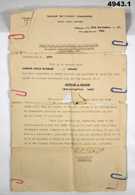 Bendigo Military Museum
Certificate, Certificate of eligibility and suitability for soldier settlement
1. Foolscap size sheet (see condition) Letterhead is for the soldier Settlement Commission. State Public Offices. Tel F 0234. Dated Melb 16 Sep 1947. Letter No 8945. In the text is Cert No. 4677 for Kenneth Edwin Beckman of Cowangi. The purpose of the land is for cropping and grazing (non irrigation land) 2. Letter quarto size paper. Letterhead of Australian Mil Forces. Tel No. M 45966 Ext 30. Victoria Echelon and records 291 Lonsdale St Melbourne dated 2 Nov 1945. In the text is printed EX V64354 K E Beckman. Cert of Discharge 294425. RAS Badge No. A 99448. Will (AAF A.131) One..admin record, ww2 -
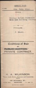 Bendigo Historical Society Inc.
Document - H.A. & S.R. WILKINSON COLLECTION: CONTRACT OF SALE
Conditions of sale by private contract dated 6th July 1932 between Bendigo Mutual Permanent Land and Building Society (seller) and J. Shade (buyer) for land situate Wood Street, California Gully, at present occupied by Mrs. Dumble as tenant, containing three roods thirty-five and two-tenths perches, having a frontage of 500 links to Wood Street by a depth of 193 links being Crown allotment 1 section P described in Crown grant volume 2129 folio 425693, together with 5-roomed weatherboard dwelling and all sundry. Also ''Lux'' wood fire stove, bath and venetian blinds. Price 340 pounds.organization, business, h.a. & s.r wilkinson real estate -
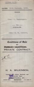 Bendigo Historical Society Inc.
Document - H.A. & S.R. WILKINSON COLLECTION: CONTRACT OF SALE
Conditions of sale by private contract dated 11th January, 1938 between Mrs. E. Banninger (seller) and Mrs. M.M. Spicer (buyer) for land situate in Wood Street, Long Gully, being Crown allotment 1 section P described in Crown grant volume 2129 folio 425693, together with 5-roomed weatherboard dwelling and all sundry, also bath, cement troughs and copper, wire doors, three venetian blinds, built in wardrobe, and vendor's interest in poultry pens built on land adjoining the above freehold, also all poultry and poultry farm equipment as per schedule on page 2. Price 550 pounds.organization, business, h.a. & s.r wilkinson real estate -
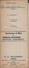 Bendigo Historical Society Inc.
Document - H.A. & S.R. WILKINSON COLLECTION: CONTRACT OF SALE
Conditions of sale by private contract dated 30th March, 1932 between A. McKinnon (seller) and P. Thompson (buyer) for land situate in Murphy Street, Bendigo being the balance of the subdivision unsold of Crown allotment 151,270A, 271A, 271C, 271R, 195, 196, 270C, 271B and 271D described in certificate of title volume 2666 folio 533101, and being the land at present occupied by the vendor, not including the allotments or read showed on plan of subdivision. Together with weatherboard dwelling and all sundry including galvanized iron tank and stand, water trough and loose timber in paddock but does not include any window or verandah blinds. Price 800 pounds.organization, business, h.a. & s.r wilkinson real estate -
 National Vietnam Veterans Museum (NVVM)
Poster - Poster, Information Board, 5 RAR 2nd Tour 1969 to 1970
An Poster, Information Board of a Schematic drawing and two colour photos with description of Battle of Binh Ba 1969. Two other photos of other actions of 2nd tour. Tiger emblem on black V. Black text on white background Under the bottom black and white photograph reads: Survivors of a land mine disaster on the 15th of June 1969. D comapny 12 Platoon 5 RAR suffered heavy casualties due a land mine detonation at Dat Do. Pictured are the six survivors. Rear Private W Morgan, Private A Tuckfield, Front B Savige, Lance Corporal R Chaplin, Lance Corporal R Knapp, Private A Van Hulst.dat do, 5 rar, pte w.morgan, pte a. tuckfield, pte b. savage, pte a van hulet, l/cpl r. chaplin, l/cpl r knapp, poster, information board, battle of binh ba, 12 platoon, 33 nva regiment, viet cong, battle honour, 1 atf -
 Bendigo Historical Society Inc.
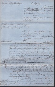
Document - CONNELLY, TATCHELL, DUNLOP COLLECTION: LEGAL PAPERS, 1878 1889
Document. Various legal papers. 1 - 1856? - Petition for Vesting Order in the matter of Diviney Michael, late of Sandhurst. Mentions Hughes Joshua and Freame H S? for Flegg Wm Sandhurst. 2 - Hughes J. Application for Vesting Order. Mentions Doran Joseph Christopher & Diviney. 3 - 1878 - In the matter of the Hope Tribute Mining Company Reg and in the matter of the Mining Companies Act 1891 between the Commercial Bank of Australia Ltd. (Appellant) and the Hope Tribute Mining Company Reg (Respondent). Appeal case. 4 - 1889 - Transfer of Land in Kerang from Ellis Asher (Postmaster) to Victorian Railways Commissioners. Contains map of said land.cottage, miners, connelly, tatchell & dunlop, diviney michael, hughes joshua, freame h s?, flegg wm, doran joseph christopher, hope tribute mining company, commercial bank of australia, ellis asher, victorian railways commissioners -
 Southern Sherbrooke Historical Society Inc.
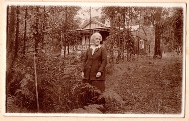
Photograph
Photo of a woman of about sixty standing in a garden with a house in the background. The woman has thick grey/white hair swept back, and she is unsmiling and looking to her left. She is wearing a dark skirt and jacket with three buttons over a pale blouse with a frilled collar. In her hands is a twig or piece of grass or similar. There is a wedding ring on her hand. The house in the background is the same house as in other photos. The land slopes upwards and Monbulk Road is most likely hidden by the thick bush behind the house. Trees and bracken edge a cleared area of land. The house is probably located at present-day 20 Monbulk Road, Belgrave and is no longer standing. -
 Bendigo Historical Society Inc.
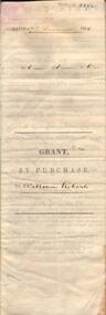
Document - JOHANSON COLLECTION: GRANT BY PURCHASE WILLIAM ROBERTS
Legal document. On front: Dated 17th December 1855. Ac1 R1 P 1. ( acres, roods, perches ) Grant by purchase to William Roberts. In pencil Allot 7 of Sec 12. Inside: 'Victoria - Township Lot. Grantee W. Roberts. Document details purchase of land by above William Roberts of Heathcote, for the sum of two pounds, 12 shillings. Allotment 7, section 12, Township of Heathcote. Land sold as Lot 14. Dated 30 July 1855. Signed by C.W. Hotham ( Sir Charles Hotham ) Property is now 42 Beauchamp Street, Heathcote ( Landata research, 28.3.2017, https://www.landata.vic.gov.au/tpc_confirm_map.aspx?pfi=45257085 )heathcote, land sale, william roberts -
 Bacchus Marsh & District Historical Society
Map, Bacchus Marsh Township and Nearby Districts Maps Volume
This volume of maps is believed to have been compiled by staff at the Shire of Bacchus Marsh and was presumably used to inform and assist Shire staff and Councillors in the carriage of their duties.This collection of maps are significant due to their rarity as many of them are unique maps made for local purposes in the Bacchus Marsh region. They are also of strong research value containing a wide variety of information including landholders, land sales, infrastructure, such as roads, bridges, public, commercial and private buildings, houses, land use, and geographic features over multiple decades from the late nineteen century into the middle part of the twentieth century.One bound volume of maps comprising cadastral maps, (indicating property owners and land boundaries), land plans and real estate auction plans and advertising material, and other maps indicating major infrastructure like proposed roads and irrigation areas. Most of the maps and plans are of Bacchus Marsh and nearby areas but some maps are of nearby towns such as Melton, Ballan and Blackwood. The volume comprises 52 pages. Most pages have a single map or plan pasted onto it but some contain 2 or 3 different maps. There are 81 maps in total. Map 1 Liquidators Sale 1896. Map 2. Woodside Estate Sale 1913. maps, maps bacchus marsh, maps bacchus marsh region -
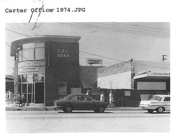 Ringwood and District Historical Society
Document, Certificate of Title and miscellaneous property records - Carter Real Estate, 122 and 124-128 Maroondah Highway, Ringwood, Victoria
Transfer of Land Act Title dated 24/4/2002 - Volume 10314 Folio 972 Crown Allotments 11H and 11J, Parish of Ringwood, Entitlement Grant to a depth of fifteen metres - 29/1/1997, City of Ringwood planning permit and diagram of office floor plan - 1973. -
 Bendigo Historical Society Inc.
Document - H.A. & S.R. WILKINSON COLLECTION: CONDITION OF SALE
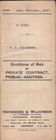
Conditions of sale by private contract dated 14th. February, 1928 between F. Ford and G. J. Wilkinson for land situate in Thistle Street, Bendigo area No. 30459 together with workshop, wash house, stable, bath, copper and wash tube for the price of 7 pounds and 10 shillingsorganization, business, h.a. & s.r wilkinson real estate