Showing 4549 items matching "historical map"
-
 Clunes Museum
Document - NEWSPAPER CUTTING AND HISTORICAL GUIDE, WHAT TO LOOK FOR IN AND WHERE TO FIND IT, 1971/1972
HISTORY LOCATIONS CLUNES SITES.1 NEWSPAPER CUTTING CLUED ONTO PAPER - HISTORY OF CLUNES .2 3 X PAGES AND MAP DETAILING PLACES OF INTEREST IN CLUNESlocal history, places of interest clunes -
Tatura Irrigation & Wartime Camps Museum
Folder, Karlsruhe, 1987
History of "Karlsruhe" homestead on Nation Trust of historical homes built by Baon Von Swaine. Also plans maps, photographs. Tape of official opening 1986Black and white mottled binder, contains newspaper articles on renovation of Karlsruhekarlsruhe homestead, lancaster, baron von swaine, tatura, documents, history, local, newspapers -
Tatura Irrigation & Wartime Camps Museum
Booklet, History of the Waranga Basin, 1989 (reprint)
Includes details of construction of Waranga systemBuff soft covered book with map of Waranga Basin and text in brown Written by Joyce Hammond giving historical information from aboriginal presence to the situation in 1977 with reference to members of the Gunn and Hammond familiesirrigation, boat club, books, history, local -
 Anglesea and District Historical Society
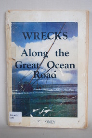
Book, J Loney, Wrecks Along the Great Ocean Road, 1967
Book first published in 1967 dealing with the shipwrecks along the Great Ocean Road. Illustrated with both maps and photographs and with a chrononolgy of the list of wrecks from pre-1800 through to 1958.Title: WRECKS / Along the / Great Ocean / Road J.K. LONEYjack loney, dewey no 910.453, book -
 Anglesea and District Historical Society
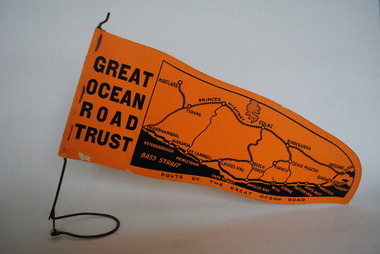
Pennant, Unknown
Orange pennant flag listing towns on and near the Great Ocean Road. List of town names on pennant - (west to east) Mortlake, Warrnambool, Nirranda, Terang, Port Campbell, Lavers Hill, Colac, Beech Forest, Apollo Bay, Wye, Birregurra, Forrest, Deans Marsh, Peterborough, Princetown, Lorne, Eastern View, Airy's Inlet, Anglesea, Torquay, Geelong, Barwon Heads.GREAT/ OCEAN/ ROAD/ TRUST. Map of Area/ Route of the Great Ocean. (Orange - on wire stand. Printed on both sides.) great ocean road trust -
 Anglesea and District Historical Society
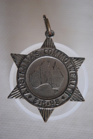
Medal Commemorative Australian Federation, 1898
Ref/ Car. 1898/2. Star shapped medal issued in 1898 tocommemorate the forthcoming Commonweath of Australia - a map of Australia in the centre divided into six states/colonies, each state represented by a ray - inscribed around the circumferance and with provision for a pin to be attached with hole and metal ring on the top ray of star. Back of medal perfectly plain.Map of Australia within ring. Around ring: "AUSTRALIA'S COMMONWEALTH" *3.6.98*medal, commemorative, australian federation -
 Anglesea and District Historical Society
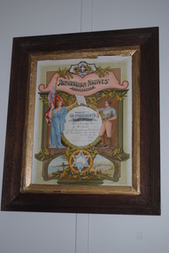
Framed Certificate, Australian Natives' Association, Estimated 1947
Ex-president's Certificate from the Australian Natives' Association with details of recipient's details in central circle - an Australian emblem on the top - female figure on one side of circle holding flag in one hand and male figure on other side / symbolising bushman? Smaller circle underneath encloses star with map of Australia in centre and six state emblems in points. Scenes either side depict native Australian first fleet and Canberra Parliament House. All decorated with wattle and in a wooden frame.Certificate reads: Branch No 311 / EX PRESIDENT'S / CERTIFICATE / This is to certify that / J.W. Read / occupied the position of President of / this branch from 20.11.45 / to 25.2.47 / faded signature of President / faded signature of Secretary. australian natives' association, j.w. read -
 Anglesea and District Historical Society
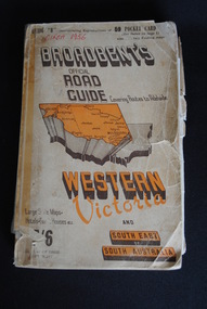
Road Directory, Broadbent's Official Road Guides Company, Broadbent's Official Road Guide Western Victoria, 1956
Contains maps and advertisements for Western Victoria in 1956 as well as some of South-East of South Australia. 240 pages. Fold out maps included.Circa 1956maps, advertisements, broadbent -
 Anglesea and District Historical Society
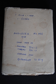
Map, Royal Australian Survey Corps, Anglesea, Victoria, 1954
Anglesea, Victoria [cartographic material] produced by Royal Australian Survey Corps. Colour; Scale [1:63,360] 1 mile to 1 inch; transverse Mercator projection; Sheet No. 866, Zone 7. Two stamps: 1. Rankine and Dobbie Pty Ltd. 2. Authorised for sale / Price 2/- / By Department of the Army Original date: November 1928.(See above)anglesea map, topographic map -
Numurkah & District Historical Society
Postcard - Postcard showing map of Australia
Postcard featuring a hand holding a map of Australia, with a bush road scene printed inside it -
Tatura Irrigation & Wartime Camps Museum
Photograph, Camp 3
Photographs taken in Camp 3, Tatura. Official group photo including the Girschik family. Children with Father Panico. Departure of internees by train. Map of invasion of Persia by Britain & Russia. Helga Griffin (nee Girschik) addressing the Tatura Historical Society and presenting a dress embroidered in Camp 3 by Helga's mother. Peter Girschik addressing Historical Society, 23 October 2007, two digitised photos.helga griffin, helga girschik, father panico, camp 3 tatura, persia -
 Inverloch Historical Society
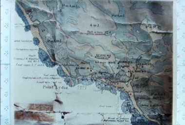
000587 - Map - Point Lydia - Harmers Haven - Location of coal test bore holes - from Iris Earnshaw
-
 Robin Boyd Foundation
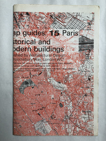
Map, Architectural Design, Map guides: 15 Paris historical and modern buildings
... Map guides: 15 Paris historical and modern buildings... of historical buildings. Map Paris Historical Buildings Modern Buildings ...Map of significant Paris buildings and categorizing of historical buildings.map, paris, historical buildings, modern buildings, walsh st library -
 Victorian Aboriginal Corporation for Languages
Periodical, Royal Historical Society of Victoria, Victorian historical journal : S.T. Gill and the arm-chair, 2009
maps, b&w illustrations, b&w photographs -
 Victorian Aboriginal Corporation for Languages
Periodical, Royal Historical Society of Victoria, Victorian historical journal : George Bass's amazing Western Port adventure, 1998
maps, b&w illustrationsgeorge bass, western port -
 Victorian Aboriginal Corporation for Languages
Periodical, Royal Historical Society of Victoria, Victorian historical journal : Australia's imperial war, 2000
maps, b&w photographsvictorian history, war history -
 Victorian Aboriginal Corporation for Languages
Periodical, Royal Historical Society of Victoria, Victorian historical journal : Victoria?s coastal history, 2003
maps, b&w illustrations, b&w photographs -
 Victorian Aboriginal Corporation for Languages
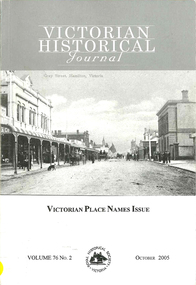
Periodical, Royal Historical Society of Victoria, Victorian historical journal : Victorian place names issue, 2005
maps, b&w photographs, word lists, document reproductions -
 Victorian Aboriginal Corporation for Languages
Periodical, Royal Historical Society of Victoria, Victorian historical journal, 2005
Includes articles on Simon Wonga, Aboriginal leader, Antecedent Force: The Port Phillip Aboriginal Protectorate Domestic European Constabulary 1840-1843, by Ian Clark.maps, b&w illustrations, b&w photographsbunurong, boon wurrung, woiworung, woi wurrung, taungurong, taungurung, wathaurung, wathaurong, jajowrong, dja dja wurrung, port phillip -
 Victorian Aboriginal Corporation for Languages
Periodical, Royal Historical Society of Victoria, Victorian historical journal : Victoria : 150 years of gold, 2001
maps, b&w illustrations, b&w photographs, document reproductions -
 Victorian Aboriginal Corporation for Languages
Periodical, Royal Historical Society of Victoria, Victorian historical journal, 2010
maps, tables, b&w photographs, document reproductions -
 Victorian Aboriginal Corporation for Languages
Thesis, Cathrine Koukmenides, Pronouns as evidence for genetic relationships in Victorian languages, 1997
Thesis on language in Victoria, includes historical notes.Maps, charts, word listspama-nyungan, warnman, gundungurra, dyirringan, wathaurong, wathawurrung, tyattyalla, wudjubaluk, wuttyabullak, woiwurrung, kulin, madhi-madhi, wadi-wadi, wamba-wamba, wemba wemba, bereba-bereba, barababaraba, colac, warrnambool, bunganditj, kulin, yorta yorta, yabula yabula, jabulajabula, dhudhuroa, pallanganmidda, gippsland, ganai, gunai kurnai -
 Victorian Aboriginal Corporation for Languages
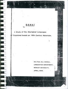
Thesis, Eve Fesl, Ganai : a study of the Aboriginal languages of Gippsland based on 19th century materials, 1985
... maps, extensive discussion of historical sources, and a fairly... Street Brunswick melbourne Ganai Gippsland Maps, word lists ...Honours thesis in linguistics (unpublished) at Monash University. Detailed studies of Gippsland languages (Ganai) including maps, extensive discussion of historical sources, and a fairly detailed grammatical study of Ganai. Includes wordlists organised by areas of meaning.Maps, word listsganai, gippsland -
 Victorian Aboriginal Corporation for Languages
Book, Through their eyes : an historical record of Aboriginal people of Victoria as documented by the officials of the Port Phillip Protectorate, 1839-1841, 1994
maps, b&w illustrations, b&w photographswathaurung, woiworong, woi wurrung, bunorong, boon wurrung, taungurong, taungurung, derrimut, william thomas, port phillip protectorate -
 Victorian Aboriginal Corporation for Languages
Book, Elizabeth Nelson, Letters from Aboriginal women of Victoria, 1867-1926, 2002
This edited collection of women's correspondence constitutes an important historical record of the experiences of Aboriginal women during a crucial period of social change. In particular the letters are valuable for the insight they offer into the impact on Aboriginal communities of government legislation and mission policies and the women's assertion of their entitlement to freedom and agency. Written by 81 different women, the letters cover such issues as children, family, religion, land, housing and material assistance.maps, b&w photographsvictorian aboriginal women, correspondence, government policy -
 Victorian Aboriginal Corporation for Languages
Book, Giordano Nanni et al, Coranderrk : we will show the country, 2013
Comprises twenty-three extracts from the Minutes of Evidence of the Coranderrk Inquiry, accompanied by an analysis of the historical text and context. The book relies strongly on primary-source materials and accurately references historical analysis from scholarly and Aboriginal perspectives. This book is derived from a verbatim-theatre performance in which professional actors portrayed the witnesses who gave evidence before the 1881 Coranderrk Inquiry.illustrations, photographs, facsimiles, maps, portraitswurundjeri, woi wurrung, william barak -
 Victorian Aboriginal Corporation for Languages
Book, Bruce Pascoe et al, Wathaurong : the people who said no, 2003
The Wathaurong people of South Western Victoria said no to European invasion. Learn about this heroic resistance to the occupation of their lands. Can white and black live together or must we be always at war? The answer can only be given by young Australians. Includes a comprehensive historical timeline.maps, colour illustrations, b&w illustrations, colour photographs, word listswathaurong, wadtharung, port philllip bay, western port bay, lorne, south west victoria, battle creek, aire river, werribee, ballarat, wathaurong aboriginal cooperative, coast action, koori studies, john batman, william buckley, aboriginal studies policy, secondary school education, hissing swan, victorian history -
 Victorian Aboriginal Corporation for Languages
Book, Sue Wesson, An historical atlas of the Aborigines of Eastern Victoria and Far South-eastern New South Wales, 2000
An extremely detailed atlas of tribes, clans, and languages in eastern Victoria and south-eastern New South Wales. Includes maps, census information about the numbers and makeup of these clans in historical records, meanings and comparative spellings of all known named tribes and clans.maps, b&w photographs, colour photographs, tables -
 Victorian Aboriginal Corporation for Languages
Book, John Henderson, Language in native title, 2002
Introduction /? John Henderson and David Nash Language and native title /? John Henderson Linguistic evidence and native title cases in Australia /? Peter Sutton Linguistic continuity in colonised country /? Jeanie Bell Country and the word: linguistic evidence in the Croker Sea claim /? Nicholas Evans Linguistics and the Yorta Yorta native title claim /? Heather Bowe The language of the Peak Hill Aboriginal people: a linguistic report in a native title claim /? Tamsin Donaldson Labels, language and native title groups: the Miriuwung-Gajerrong case /? Greg McIntyre and Kim Doohan Historical linguistic geography of south-east Western Australia /? David Nash Language ownership: a key issue for native title /? Michael Walsh Can lexicostatistics contribute an absolute time-scale to discussions of continuity of occupation in native title determinations? /? Barry Alpher Linguistic stratigraphy and native title: the case of ethnonyms /? Patrick McConvell Making your skin fit properly: displaced equivalence in 'skin' systems in the Barkly /? Gavan BreenMaps, tables, b&w diagramsyorta yorta, yoda yoda, yabala yabala, bangerang, shepparton, miriuwung, gajerrong, native title