Showing 15563 items
matching stillwell-valley
-
 Canterbury History Group
Photograph - Canterbury Lawn Bowls
Bowlers on the Canterbury Lawn Bowls Green at 9 Wattle Valley Road. Malone's Hotel can be seen in the background. black and white photographcanterbury, canterbury lawn bowls, wattle valley road, bowling clubs, malones hotel -
Canterbury History Group
Photograph - Members of the Canterbury Lawn Bowling Club on the green
Members bowling on the green at 9 Wattle Valley Road Canterbury. Part of a set of four black and white photographs names and date unknown.canterbury, canterbury lawn bowling club, wattle valley road, bowling clubs -
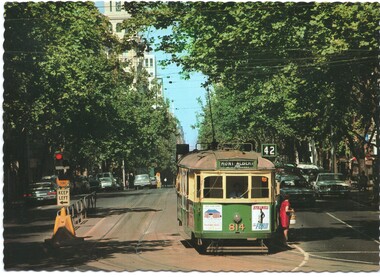 Melbourne Tram Museum
Postcard - Collins Street at Spring Street - Biscay W5 814, Biscay Greetings, late 1980's
Postcard looking west along tree lined Collins Street at Spring Street with W5 814 (Mont Albert Route 42) about to turn into Spring Street. Note the flashing red light assembly above the Safety Zone prow to try and warn motorists about it when they were turning from Spring St. The tram has advertisements for Stillwell Ford and a rent car company,Yields information about Collins Street late 1970s.Postcard - serrated edges, Collins Street at Spring St - Biscay Greetings, BG 82collins street, tram 814, w5 class, trams, tramways, spring street, safety zones -
 Kew Historical Society Inc
Photograph - Yarra in Flood from Willsmere, North Kew, 1923
Flooding of the Yarra Valley, including that section of the Yarra bordering Kew and Kew East in the north and west of the municipality, was a regular occurrence. Extreme flood events of the Yarra River are recorded to have occurred in 1891, 1901, 1916, 1923 and 1934. The Municipality of Kew's response to these floods was to enact planning decisions restricting residential development in flood prone areas following the floods of 1916, 1921 and 1934. While floods continued after the development of the Upper Yarra Reservoir (construction 1948-57), the regularity and extent of these inundations diminished. Original, large sepia photograph showing men, women and children who have gathered on a grassy verge, probably farm land, to look out across the flooded Yarra Valley at Willsmere, North Kew. In the medium distance are three houses that are largely submerged by the flood waters as well as a number of Eucalypts. Judging by the clothes of the spectators, the date might be 1901 or 1916, but probably the latter due to the hats worn by a number of the women. Inscribed reverse: "Gift of Kerrie Woollard (KCC) (P)C.1923yarra river valley, kew east (vic.), floods, willsmere -
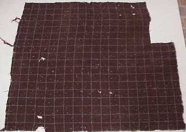 National Wool Museum
Sample, Textile
Fred Murgatroyd's twed fabric to be used in conjunction with Nino at Foster Valley for Loom in G2textile industry textile mills, foster valley mill pty ltd valley worsted mill, tweed, murgatroyd, mr fred, textile industry, textile mills -
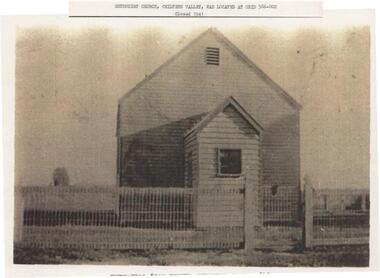 Rutherglen Historical Society
Image, 1994
One of two sepia coloured photographs, photocopied on A4 paper. Photographs copied either way up. Each has a typed caption.Caption: "Methodist Church, Chiltern Valley, was located at grid 586-002 | Closed 1941"methodist church, churches, chiltern valley -
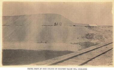 Rutherglen Historical Society
Image, 1994
One of two sepia coloured photographs, photocopied on A4 paper. Photographs copied either way up. Each has a typed caption.Caption: "Gravel heaps at grid 575-602 of Chiltern Valley No. 2, Gold-Mine"chiltern valley, mining industry, gold mines, gold mining -
 Numurkah & District Historical Society
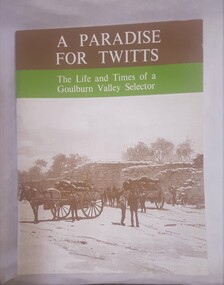
Book - Family History Book, A Paradise of Twitts
Book was written & published by ex-local, Adrian Twitt in 1974. Donated surplus books to H.S. for sale (& keep one copy)( Set of 18)Book with Brown, Green cover with sepia photo of horse & cart near a wheat-bag stack Title: A Paradise of Twitts, the life and times of a Goulburn Valley selector (Adrian Twitt, 1974)book, family history, settlement, twitt -
 Greensborough Historical Society
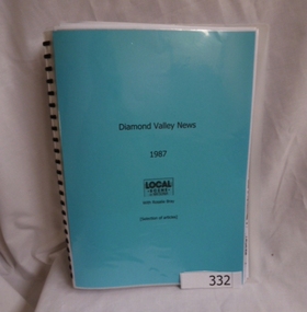
Folder, Rosalie Bray, Local Scene in Watsonia with Rosalie Bray 1987, 1987_
This local news column details events, people and places of interest as they occurred in Watsonia in 1987.This column was a means of advertising for local community groups and gives a snapshot of the Watsonia area at the time.Spiral bound plastic binder with 20 pockets. Blue title page. Contains photocopies of selected articles from Diamond Valley News 1987.watsonia, rosalie bray, diamond valley news -
 Greensborough Historical Society
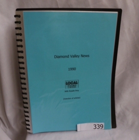
Folder, Rosalie Bray, Local Scene in Watsonia with Rosalie Bray 1990, 1990_
This local news column details events, people and places of interest as they occurred in Watsonia in 1990.This column was a means of advertising for local community groups and gives a snapshot of the Watsonia area at the time.Spiral bound plastic binder with 20 pockets. Blue title page. Contains photocopies of selected articles from Diamond Valley News 1990.watsonia, rosalie bray, diamond valley news -
 Greensborough Historical Society
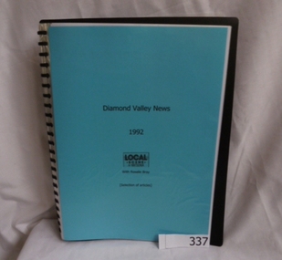
Folder, Rosalie Bray, Local Scene in Watsonia with Rosalie Bray 1992, 1992_
This local news column details events, people and places of interest as they occurred in Watsonia in 1992.This column was a means of advertising for local community groups and gives a snapshot of the Watsonia area at the time.Spiral bound plastic binder with 20 pockets. Blue title page. Contains photocopies of selected articles from Diamond Valley News 1992.watsonia, rosalie bray, diamond valley news -
 Greensborough Historical Society
Folder, Rosalie Bray, Local Scene in Watsonia with Rosalie Bray 1994, 1994_
This local news column details events, people and places of interest as they occurred in Watsonia in 1994.This column was a means of advertising for local community groups and gives a snapshot of the Watsonia area at the time.Spiral bound plastic binder with 20 pockets. Blue title page. Contains photocopies of selected articles from Diamond Valley News 1994watsonia, rosalie bray, diamond valley news -
 Greensborough Historical Society
Folder, Local Scene in Watsonia with Rosalie Bray 1995, 1995_
This local news column details events, people and places of interest as they occurred in Watsonia in 1995.This column was a means of advertising for local community groups and gives a snapshot of the Watsonia area at the time.Spiral bound plastic binder with 20 pockets. Blue title page. Contains photocopies of selected articles from Diamond Valley News 1995.watsonia, rosalie bray, diamond valley news -
 Greensborough Historical Society
Folder, Local Scene in Watsonia with Rosalie Bray 1991, 1991_
This local news column details events, people and places of interest as they occurred in Watsonia in 1991.This column was a means of advertising for local community groups and gives a snapshot of the Watsonia area at the time.Spiral bound plastic binder with 20 pockets. Blue title page. Contains photocopies of selected articles from Diamond Valley News 1991.watsonia, rosalie bray, diamond valley news -
 Halls Gap & Grampians Historical Society
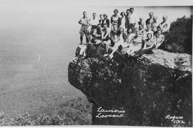
Photograph, C 1930s/40s
C 1930's/40's. This is a photo of a group of tourists on Lawson's Lookout, taken by Gilbert Rogers, a well known Hall's Gap photographer.The photo shows a group of twenty-one men and women posed on a rocky outlook. A bushy valley can be seen below with a road winding into the distance."Lawson's Lookout Rogers 1012" inscribed into lower part of photo.scenery, lookouts, people, tourists -
Bendigo Historical Society Inc.
Map - VICTORIA HILL - MAP - HAPPY VALLEY RD - DARE ST
Small map showing some blocks of land in the Happy Valley Road, Dare Street and Wells Streets area. Three of the blocks are in the name of Rae.map, bendigo, victoria hill, victoria hill, victoria hill - map - happy valley road - dare street, w rae, j rae -
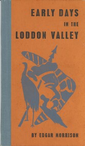 Bendigo Historical Society Inc.
Book - EARLY DAYS IN THE LODDON VALLEY, 1966
Early days in the Loddon Valley, Memoirs of Edward Stone Parker 1802-1865, 98 Pages, with photographs and maps, Limited Edition of 1000 copies,Edgar Morrisonhistory, australian, loddon valley, history of loddon valley, castlemaine, daylesford, edward stone parker, aborigines, aboriginal stations -
Tatura Irrigation & Wartime Camps Museum
Book, Closer Settlement Days
Story of three Scottish imigrant families - Geals, Stark, Forbes. Arrived in Australia 1924White plastic front cover. Black spine and backcover. Black letters title CS Days in the Goulburn Valley by Agnes Mary Brown (Nessie)closer settlement days, geals, stark, forbes, brown a, brown n, undera, tatura, closer settlement gv, books, history, local -
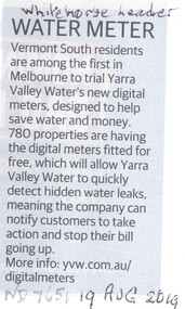 Whitehorse Historical Society Inc.
Article, Water Meter, 2019
Vermont South residents are among the first in Melbourne to trial Yarra Valley Water's new digital meters.Vermont South residents are among the first in Melbourne to trial Yarra Valley Water's new digital meters. Designed to alert customers of water leaks.Vermont South residents are among the first in Melbourne to trial Yarra Valley Water's new digital meters. vermont south, water, yarra valley water -
Lakes Entrance Regional Historical Society (operating as Lakes Entrance History Centre & Museum)
Postcard, 1940 c
For over 20 years from 1893 gold mining was undertaken in the mountains around Glen Wills.Black and white postcard looking towards the Glen Wills Road situated between the valley and steep hills taken in summer Glen Wills Victoriaaccommodation, hotels -
 Sunbury Family History and Heritage Society Inc.
Photograph, Rupertswood Viaduct
The stone bridge is one of the many bridges built along the Bendigo Rail Line. This one along with four others ar in Sunbury which were built in the late 1850s. his bridge spans the Ruoertswood Viaduct which is north of the Sunbury Station. The building in the LH corner was a pump house where water was pumped and taken to the water tower on Sunbury Station where the steam trains stopped to replenish the water tanks. The Bendigo Rail Line was the first Government owned and operated to be constructed in Victoria. Along the railway a number of famous bridges and tunnels were built and are of historical significance. The bridge spanning the Rupertswood Viaduct is one of them. A black and white photograph with a cream border of a high bridge spanning a deep valley. The roof of a small building is visible in the bottom LHS corner of the photograph.bridges, railways, rupertswood viaduct -
Canterbury History Group
Ephemera - 36 Wattle Valley Road Canterbury, 1994
Real Estate Advertisement for the auction on 12th November 1994 of 36 Wattle Valley Road c1937. Includes black and white sketch of the exterior of the housecanterbury, wattle valley road, reeves john, sinclair & co -
Canterbury History Group
Photograph - Rear view of 3 shops in Maling Road. View from the Wattle Valley Road car park, Jan Pigot, 1994
Coloured photograph of the rear view of 3 shops, No. 114, 116 and 118 Maling Road. View from the Wattle Valley Road car park.canterbury, maling road, shops -
Canterbury History Group
Document - Mirabella, 62 Wattle Valley Road, Canterbury
, From the Camberwell Conservation Study - Significant Sites, on "Mirabella" 62 Wattle Valley Road Canterbury. Includes a list of comparative sites in the Camberwell area.canterbury, wattle valley road, mirabella, camberwell conservation study, williams> frank, zelman family -
Canterbury History Group
Photograph - Canterbury Mansions, Jan Pigot, 27/03/1993 12:00:00 AM
Coloured photograph of the view of the Canterbury Mansions from the front door facing Canterbury Road. Also visible are Wattle Valley Road and Maling Road.canterbury, maling road, shops, victorian architecture, canterbury post office -
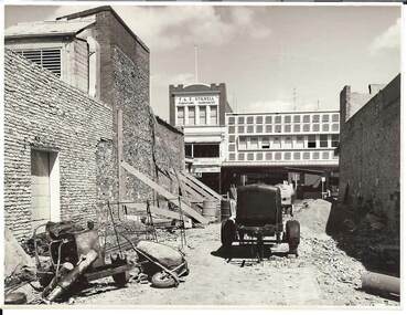 Bendigo Historical Society Inc.
Photograph - BENDIGO ARCADE, c1950
Black and white photograph. Demolition site, taken from Old Bennett's Arcade. Brick walls each side, wheelbarrows and machinery on site. Opposite 2 & 3 storey buildings with shops and offices. In image F & E Stillwell, Furniture Warehouse. On windows 'Pitson Bros', GH? Pitson, GJ? Pitson, Public Accountants, Estate Agents, Travel Agents, Sister McKenzie, Chiropodist. Identified by James Lerk as a Alan Doney photo.Alan Doney Photoplace, arcade, bendigo arcade -
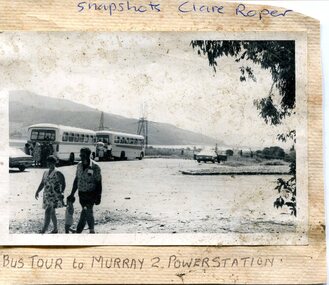 Kiewa Valley Historical Society
Photograph- Bus tour to Murray 2 Power Station
The Murray Region Hydroelectric Power Stations are two of seven hydro power stations, located near Khancoban in NSW. The two power stations are part of the Snowy Mountains Hydro-electricity Scheme, which is an extensive hydroelectricity and irrigation complex constructed in south-east Australia between 1949 and 1974 and now run by Snowy Hydro. Although both power stations are located in NSW, since 1 July 2008 all power generated has been allocated to the Victorian region of the National Electricity Market. Murray 2 Power Station was the first in the Snowy Scheme to use Japanese supplied large electrical and mechanical components Photographs demonstrate local Kiewa Valley residents enjoying an educational visit to Murray 2 Power Station which holds significance to the early history of the Hydro-electric Scheme in the area. Also demonstrates a pictorial history of social activities undertaken during this periodBlack and white photograph mounted on buff card Bus tour to Murray 2 Power Station showing 2 buses and group of Kiewa Valley residentsHandwritten in blue ink above photo "Snapshots Clare Roper' Handwritten in black ink below photo "Bus tour to Murray 2 Power Station'kiewa valley residents, clare roper -
 Kiewa Valley Historical Society
Paper Sheet - Shire of Bright Plans
Oblong sheet of paper - bright yellow (or orange). Black typed writing and subdivision maps of the Kiewa Valley Planning Scheme in the Shire of Bright. Circa 1980s2 pages of maps and scriptshire of bright, maps, kiewa valley -
 Greensborough Historical Society
Folder, Rosalie Bray, Local Scene in Watsonia with Rosalie Bray 1988-1989, 1988-1989
This local news column details events, people and places of interest as they occurred in Watsonia in 1988-89.This column was a means of advertising for local community groups and gives a snapshot of the Watsonia area at the time.Spiral bound plastic binder with 20 pockets. Blue title page. Contains photocopies of selected articles from Diamond Valley News 1988-89.watsonia, rosalie bray, diamond valley news -
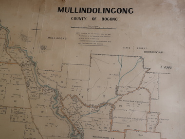 Kiewa Valley Historical Society
Parish Map - Mullindolingong, County of Bogong
The Department of Lands regularly updated the occupiers with leases or licences of the land.The names of the early settlers of the Kiewa Valley occupying land by lease or licence are shown. Many of these familie's descendants still live in the Kiewa Valley.Government (Lands Department?) cloth map showing the leases or licenses of occupiers of the land in the valley. The Kiewa River is shown in blue and roads in yellow. There is no date on the map.parish of mullindolingong map, settlers of the kiewa valley