Showing 6697 items
matching river
-
 Orbost & District Historical Society
black and white photograph, mid - second half 20th century
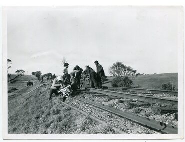
This photograph was taken near the Nicholson River Bridge. The gang re-laying the rail tracks on the Bairnsdale - Orbost line were working in the Bruthen area. In this photograph the men had just finished work near the Nicholson River Bridge.This photograph is associated with the Easy Gippsland Railway.A black / white photograph of a group of men working on a railway line. There is another group behind them.on back - typed information as beloweast-gippsland-railway nicholson-railway railway-construction -
 Tatura Irrigation & Wartime Camps Museum
Folder, Rural Water Corporation
Contents include material on dethridge water meter, Murray-Darling basin, Lake Nillahcootie, Western port rivers. Management study of State of the rivers, Rural Water Commission school project package. 3 papers on Lake DartmouthFolder, marbled black and white cover. metal lever insiderural water corporation, tatura, water, documents, reports -
 Port of Echuca
Black and white photograph
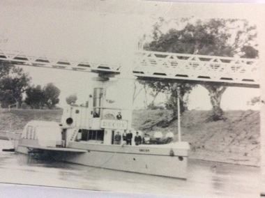
P.S Decoy was built in Scotland and reassembled in 1878 in Melbourne. It steamed to Goolwa, arriving in July 1878. It was used on the Darling River, and as a South Australian tug. In 1905 it sailed to Fremantle W.A for use as an excursion vessel. It was towed back to work on the inland river trade on the Darling -Murray system in 1909. It is now a house boat at Mannum. It's owner is Dick Bromhead.( Ref; Parsons, Ron. "Ships of the inland Rivers. P. 65.)The P.S Decoy is significant because it worked as a passenger vessel as well as a transport vessel. It was built in Scotland and reassembled in Melbourne. It was built to use coal, but when it started work on the inland rivers system it was converted to wood fuel.Two black and white photographs ( P000385.1 is missing) of the P.S Decoy passing under a bridge. There are high banks behind the boat and there are nine people on board.On the boat is the word 'Decoy' written on the bow and under the wheelhouse.p.s decoy, darling river, murray river, goolwa, mannum, passenger vessel, bromhead, dick -
 Port of Echuca
Black and white photograph, Early 20th Century
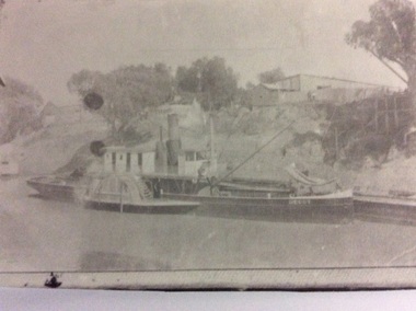
P.S Decoy was built in Scotland and reassembled in 1878 in Melbourne. It steamed to Goolwa, arriving in July 1878. It was used on the Darling River, and as a South Australian tug. In 1905 it sailed to Fremantle W.A for use as an excursion vessel. It was towed back to work on the inland river trade on the Darling -Murray system in 1909. It is now a house boat at Mannum. It's owner is Dick Bromhead.( Ref; Parsons, Ron. "Ships of the inland Rivers. P. 65.)The P.S Decoy is significant because it worked as a passenger vessel as well as a transport vessel. It was built in Scotland and reassembled in Melbourne. It was built to use coal, but when it started work on the inland rivers system it was converted to wood fuel.A black and white copy of a photograph of the P.S Decoy tied up to a riverbank with a barge alongside . The banks are high and there are buildings on the top of the banks.On the boat is the word 'Decoy' written on the bow .p.s decoy, darling river, murray river, goolwa, mannum, passenger vessel, bromhead, dick -
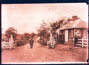
 Orbost & District Historical Society
black and white photograph, July 1897
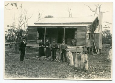
Snowy River Shipping Company formed in 1880. They were soon shipping produce (mainly vegetables) from the area to Melbourne. The Snowy River Shipping Company was formed by Mr Henry James during the 1880s, with Captain McNeil as master. Captain McNeil was an always cheerful Marlo identity and local children had many times sailing with him on the river. Captain McNeil with tug went out through the entrance and brought in the schooners.This photograph is associated with an early Marlo identity.A black / white photograph of five people, three men and two women, standing in front of a wooden cottage. The man on the left is wearing what appears to be a ship's captain's uniform.on back - "Capt. McNeil in front of house, Marlo, July 1897" -
 Wangaratta Historical Society
Toll Gates, Wangaratta Toll Bridge, Mid 19th Century
Wangaratta Toll Gates were erected after the punt was sunk and the new bridge over the Ovens river was opened in 1855; a charge was made for people, animals, carts, cars and buses and trucks later on. A gatehouse keeper lived in a residence near the gates to charge users when they crossed. The gates were refurbished by the students at the local GOTAFE college and are being rehoused as a feature of the river beautification works along the Ovens River.The Toll Gates were on the first (and only bridge at the time) that crossed near the junction of the Ovens & King rivers at Wangaratta in the mid 1800's. They are a vital part of the city's heritage.Two white timber gates, hung on white timber posts by metal hinges. wangaratta toll gates -
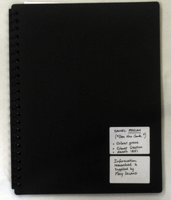 Orbost & District Historical Society
folder, Daniel Moylan (Dan the Cook), October 2012
This research record was part of a thesis that Mary Doland was preparing.This record is an excellent research tool for the study of the Indigenous history of Orbost.A 38 pp black spiral bound plastic folder containing a CD and research evidence compiled by Mary Doland on the topic of Dan Moylan, known as "Dan the Cook". He was speared to death in 1851 at Orbost Station, Snowy River.handwritten on a white label - Daniel Moylan handwritten on a white label below -Information researched and supplied by Mary Doland (Dan the Cook) Orbost grave Orbost station death 1851daniel-moylan aboriginal-history-orbost -
 Bendigo Historical Society Inc.
Photograph - BENDIGO HISTORICAL SOCIETY COLLECTION: KENNEDY'S OLD STABLE BUILDING , BARNADOWN
Colour photograph of Kennedy's old stables, Barnadown, situated near the Burke and Wills Memorial site. Shed has timber uprights and iron roof, no cladding on the walls. Large trees behind. Property is situated near the Campaspe River.agriculture, farm, kennedy's woolshed -
Port Melbourne Historical & Preservation Society
Photograph - Double-sided aerial photograph, Hobson's Bay and the Yarra River/Port Phillip and Western Port Bay, Surveyor General and Director of Mapping, Apr 1990
Landsat imagery - an extract from the atlas of VictoriaAerial photos of Port Phillip and Western Port (double sided aerial photographs). 1995 side A: Hobson's Bay and Yarra River - aerial photo mosaic; side B. Port Phillip and Western Port Bays - satellite photo.port of melbourne authority -
Port Melbourne Historical & Preservation Society
Photograph - Nairana, 15 Jan 1942
"Nairana" probably in the Derwent River (?). Turbine vessel built just before WWI and commandeered by British Government as an aircraft carrier. Later ferry to Tasmania and went around west of Station Pier, came to Australia c 1920/21.maritime, transport - shipping, nairana -
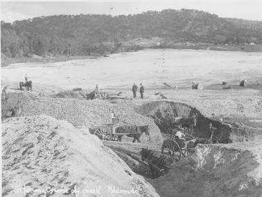 El Dorado Museum Association Inc.
Photograph (item) - Digital Image
Altering course of Reedy Creek, El Dorado. Cocks Pioneer Electric Gold & Tin Mine Company was formed in 1899. The company's first power station, located at the eastern end of the valley began operating with its 340 Kilowatt steam-powered generator. By 1909, from 2,500,000 cubic yards worked, reported recovery was 17,284 ounces of gold and 224 tons of tin ore. By 1909, Cocks Pioneer’s power plant had become inadequate and uneconomical. The barge was floated downstream about a mile, but lost time caused the operations to cease. Following testing, a new mine was established by diverting Reid's Creek at a cost of £25 000. Settling dams were built, one of which held 1,935,900 cubic feet. Sold earth banks, built against a wall of stringy bark saplings constructed and laced with vertical props, were built. In 1914, the company was reformed as Cock’s Pioneer Gold and Tin Mines NL, another power station was constructed at the western end of the township, near the junction of Clear and Reid's Creeks. From 6,800,000 cubic yards of material processed, the returns were 64,397 ounces of gold and 855 ton of tin. Cocks Pioneer mine then moved the barge downs stream and continued sluicing. In 1929 Cocks Pioneer Electric Gold and Tin Mining Company ceased operations due to a drop in values. Cock’s Pioneer Gold and Tin Mines NL carried on large-scale hydraulic sluicing operations until 1941. Handwritten across the front: 'Altering course of creek. Eldorado'mining, gold, tin, sluicing, reedy creek, cocks pioneer, el dorado, eldorado, men, horses -
 Victorian Aboriginal Corporation for Languages
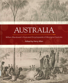
Book, Harry Allen, Australia : William Blandowski's illustrated encyclopaedia of Aboriginal Australia, 2010
William Blandowski was an explorer, natural scientist and artist who led a Victorian government expedition to the junction of the Murray and Darling Rivers from 1856 to 1857. This is the first publication in English of his nineteenth century illustrated encyclopaedia of Aboriginal life.Maps, b&w illustrationsaboriginal australian history, pictorial histories, william blandowski -
Victorian Aboriginal Corporation for Languages
Book, Harry Allen, Australia : William Blandowski's illustrated encyclopaedia of Aboriginal Australia, 2010
William Blandowski was an explorer, natural scientist and artist who led a Victorian government expedition to the junction of the Murray and Darling Rivers from 1856 to 1857. This is the first publication in English of his nineteenth century illustrated encyclopaedia of Aboriginal life.b&w illustrations, mapswilliam blandowski, pictorial works -
 Clunes Museum
Photograph
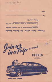
PICTURESQUE SOUVENIR OF CLUNES. A FOLDER OF 8 PHOTOS CONSISTING OF VIEWS OF CLUNES 1. 4 PANORAMAS 2. CLUNES HOSPITAL 3. OLD POST OFFICE 4. TALLAROOP RIVER CLUNES 5. 2 OF FRASER STREET, CLUNESJOIN US IN A TRIP AROUND CLUNESlocal history, photography, photographs, township & buildings -
 Bendigo Historical Society Inc.
Slide - DIGGERS & MINING. DIGGERS AND MINERS, c1850s
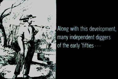
Diggers & Mining. Diggers and miners. Along with this development, many independent diggers of the early 'fifties' - - - Slide shows a miner caring a shovel and a rope. A cradle by the river in the background. Markings: 30 994:LIF I. Used as a teaching aid.hanimounteducation, tertiary, goldfields -
 Kew Historical Society Inc
Map, Robert Russell, Map Shewing the Site of Melbourne and the Position of the Huts & Buildings Previous to the Foundation of the Township by Sir Richard Bourke in 1837
Map shows the first layout of Melbourne by Government surveyor Robert Russell, who accompanied Governor Richard Bourke in 1837. The surveyed blocks extend from present-day Flinders Street to Lonsdale Street, and Spring Street to Spencer Street, with extensive vacant land west to a salt lake (afterwards Batman's Swamp, later drained), north beyond Flagstaff Hill and south towards South Melbourne. Vegetation coverage is indicated, and tracks and existing buildings and cultivated land are shown.Printed map was created by Day & Haghe, Lithographers to the Queen, sometime after 1838, when the company received its Royal appointment. Copies of the 1837 map exist in several major map collections in Australia; most are uncoloured. This particular map is the earliest in the Kew Historical Society's map collection. It is a nationally significant artefact. Black and white lithographed map hand-coloured in blue and yellow gouache of the town of Melbourne in 1837. In contrast to the original lithograph, the river and the township blocks are coloured blue and yellow. A similar, partly coloured copy is in the collection of the University of Melbourne.maps - melbourne - 1830s, governor sir richard bourke, robert russell - surveyor, cartography -
Beechworth Honey Archive
Map- Albury/Wodonga
(5x) Map centred on Albury and Wodonga. Shows Albury and Wodonga, Murray River, Hume Highway, Murray Valley Highway and Riverina Highway. Scale 1:50,000. Paper is white on back and yellow on front. Ca 1974-1975 Labelled 'Albury series R 652'map, albury, wodonga, paper, beechworth honey -
 Wodonga & District Historical Society Inc
Album - Hume Reservoir Australia Album - Quarry plant being erected September 1921
This set of photos is from a leather bound album bearing the inscription "HUME RESERVOIR AUSTRALIA" plus 'The Rt. Hon. L. C. M. S. Amery, P. C., M .P.' all inscribed in gold. It was presented to The Rt. Hon. L. C. M. S. Amery, P. C., M. P, Secretary of State for Dominion Affairs on the occasion of his visit to the Hume Reservoir on 2nd November 1927. This album is of local and national significance as it documents the planning and development of the Hume Reservoir up to 1927. It was the largest water reservoir in the British Empire. The album records the pioneering engineering work that went into its construction.DEPARTMENT OF PUBLIC WORKS, N.S.W. RIVER MURRAY WATERS SCHEME. HUME RESERVOIR. 7. Quarry plant (New South Wales) being erected, September 1921. Murray Flats (in foreground) and Mitta Mitta Flats (beyond) flooded.hume reservoir australia, river murray waters scheme, quarry plant hume -
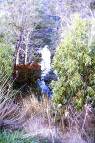
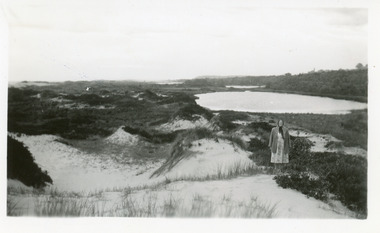 Lakes Entrance Historical Society
Photograph, 1950c
Also enlargement 15x25cmBlack and white photograph of the Warm Holes, from the sand hummocks looking west. The Warm Holes are the remnant of Reeves River, the original waterway from the Gippsland lakes to the natural entrance. Lady with shawl in foreground. Lakes Entrance Victoria waterways, topography -
Lakes Entrance Historical Society
Book, Gippsland Heritage Journal - issue 23, 1999
This issue contains articles on the McMahon brothers voyage to Sydney by rowing boat, Dorothy Humphreys Soprano, Photographers Bert Boardman and Neil Macfarlane, Aboriginal historical sites on the Snowy river, Wilson's Promontory National Park, Crosslea Hphotography, aboriginals, ships and shipping -
 Lakes Entrance Historical Society
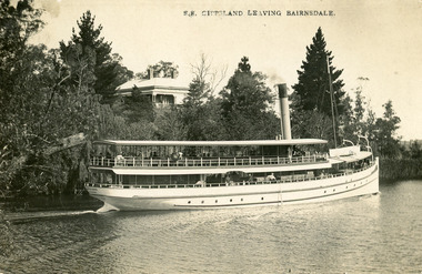
Postcard - S.S. Gippsland, Segerberg and Bulmer, 1909
S S Gippsland was launched at Paynesville 1908. Letter on back mentioning 'Our New Boat'Black and white postcard print showing S S Gippsland in Mitchell river at Bairnsdale, shows three pine trees, large house vegetation on eastern bank, ship leaving Bairnsdale newly painted. Lakes Entrance VictoriaS.S. Gippsland Leaving Bairnsdalevegetation, waterways, ships and shipping, houses -
 Lakes Entrance Historical Society
Photograph - Foreshore Lakes Entrance, Bulmer H D, 1923c
Second copyBlack and white photograph showing aerial view of the entrance to the Gippsland Lakes, shows Cunninghame Arm, North Arm, Reeves River and Hopetoun Channel, Rigby Island and Snake Island, the barrier on right foreground. Lakes Entrance Victoriawaterways, islands, aerial photograph, fishing industry, coast -
 Lakes Entrance Historical Society
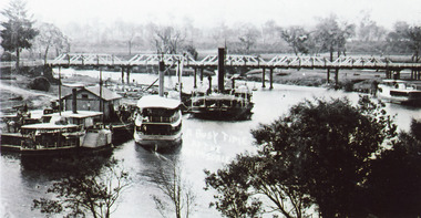
Photograph - Bairnsdale Wharf, 1911
Black and white photograph showing P S Tanjil, S S Gippsland and dredge Pioneer at Bairnsdale wharf, steamer J C D at opposite bank. Early road bridge across Mitchell River. Bairnsdale Victoriaships and shipping, waterways, wharfs, bridges -
 Bendigo Historical Society Inc.
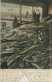
Postcard - Alice McGregor Postcard Collection, 1900 - 1920
Alice McGREGOR Born: 1908; unknown parents. Possibly adopted by the Salter family? Electoral Roll 1936: Highland Terrace Kangaroo Flat. Alice Mary Salter and William Robert Salter living together; presumed to be sister and brother. William Robert Salter was killed in a MVA in Bendigo in 1937 aged 26. In Victoria in 1938, Alice Mary Salter married James Thomas McGregor (born Victoria 1917, died Victoria 1983, buried Fawkner Cemetery) Lived: 1968; 22 Wade Street Golden Square Alice McGregor Died: 1999 aged 91 at Anne Caudle Centre, Bendigo Buried: Kangaroo Flat Cemetery See additional research. Postcard Album of Alice McGregor contained 86 post cards.Postcard Album of Alice McGregor containing 86 post cards. See 1400 Colour image of fish on Cannery Wharf, Fraser River, British Columbia, Canada 4 people overlooking a vast pile of fish. Wharf in background Addressed to Miss A. Stapleton, Arcade, Bendigo, Victoria, Australia Sender - Harold Nation, Cranbrook, British Columbia, Canada dated Oct 2 '05 postcard, collector, alice mcgregor -
 Melbourne Tram Museum
Negative, Wal Jack, 10/02/1941 12:00:00 AM
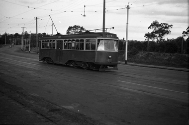
Black and white negative, by Wal Jack, of No.Y1 611 inbound in Swan St Richmond or Burnley after crossing the Yarra River bridge. Photo dated 10-2-1941 in the Wal Jack album along with details of the location.trams, tramways, swan st, y1 class, burnley, tram 611 -
 Melbourne Tram Museum
Negative, Wal Jack, 1/09/1941 12:00:00 AM
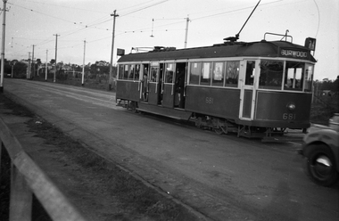
Black and white negative, by Wal Jack, of CW5 681, (Burwood, Route 74) in Swan St Burnley, prior to crossing the Yarra River. Photo dated 1-9-1941 in the Wal Jack album along with details of the location.trams, tramways, burnley, cw5 class, swan st, route 74, tram 681 -
 Phillip Island and District Historical Society Inc.
Photograph, Launch of the Penguin, 1940s
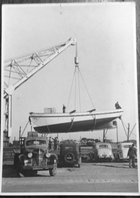
The Legg family boat, Penguin, was launched on the Yarra River.Matt black and white photo of the launch of the Penguin by craneNilfishing boat-penguin, legg family, fishing boats -
 Greensborough Historical Society
Slide - Photograph, John Ramsdale, Plenty Gorge: Slide 11, 1990s
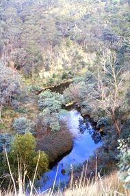
Photograph shows a river through bushland; this is the Plenty Gorge.Part of the John Ramsdale collection of slides and audio visual material.Colour photograph scanned from slide.No maker's marks. No caption on slide.plenty river, plenty gorge metropolitan park -
 Greensborough Historical Society
Slide - Photograph, John Ramsdale, Plenty Gorge: Slide 59, 1990s
Photograph shows a river through bushland. This is in Plenty Gorge.Part of the John Ramsdale collection of slides and audio visual material.Colour photograph scanned from slide.No maker's marks. No caption on slide.plenty gorge, plenty gorge metropolitan park -
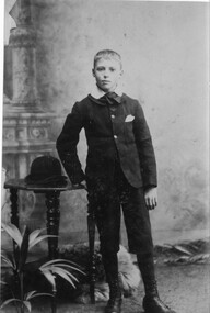 Halls Gap & Grampians Historical Society
Photograph - Sepia, C 1890
The Knight family ran a teashop at Henham and then on the Wannon riverPhoto shows Augustus (Gus) Knight C 1890 probalby in a professional photographer's studio Gus is standign with his hand resting on a table people, knight