Showing 10429 items
matching sites
-
 Federation University Historical Collection
Photograph, Lydiard Street South Streetscape Featuring Carlton and United Breweries, 10/12/1994
This image was taken to the commenement of the Stage 3 Ballarat School of Mines development on the Brewery site. Coloured photograph looking north alonf Lydiard Street South.towards Craig's Royal Hotel. carlton and united breweries, ballarat school of mines, brewery building, ballarat brewery -
Federation University Historical Collection
Photograph, Ian Robinson (SMB Audio Visual), Carlton and United Breweries, Lydiard Street South, 10/12/1994
This image was taken to the commenement of the Stage 3 Ballarat School of Mines development on the Brewery site. Coloured photograph of the former Calrlton and United Brweries, Lydiard Street South Ballarat.carlton and united breweries, ballarat school of mines, brewery building, ballarat brewery -
Federation University Historical Collection
Photograph, Ian Robinson (SMB Audio Visual), Demolition of Carlton and United Breweries, Lydiard Street South, 10/12/1994
This image was taken to the commenement of the Stage 3 Ballarat School of Mines development on the Brewery site. Coloured photograph of the former Calrlton and United Breweries, Lydiard Street South Ballarat, while under demolitioncarlton and united breweries, ballarat school of mines, brewery building, ballarat brewery -
Federation University Historical Collection
Photograph, Ian Robinson (SMB Audio Visual), Demolition of Carlton and United Breweries, Lydiard Street South, c1994
This image was taken to the commenement of the Stage 3 Ballarat School of Mines development on the Brewery site. Coloured photograph of the former Calrlton and United Breweries, Lydiard Street South Ballarat, while under demolitioncarlton and united breweries, ballarat school of mines, brewery building, ballarat brewery, lydiard street south -
Ringwood and District Historical Society
Newspaper Cutting, The Sun, Ringwood Development article (Sun Newspaper) 23 Aug 1960, 23-Aug-60
Article about land 'frieze' of the 16 acres of land for the proposed development site for Eastland.Article about Ringwood development in Sun newspaper. Double page. +Additional Keywords: Lavis, A.G., Mayor / Dwerryhouse, F.P., Town ClerkLand 'Frieze' at Ringwood. -
 Alfred Health (The Alfred, Caulfield Hospital, and Sandringham Hospital)
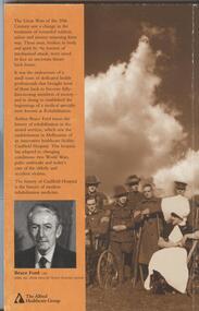
Book, The wounded warrior and rehabilitation: including the history of no. 11 Army General Hospital - Caulfield Rehabilitation Hospital, No publisher listed
Key document recording history of hospitals located on Caulfield Hospital site since 1916.Key document outlining medical treatment research and training on Caulfield Hospital site in Kooyong Road MelbournePaper back edition of The wounded warrior and rehabilitation: including the history of no. 11 Army General Hospital - Caulfield Rehabilitation Hospital Published by The Alfred Healthcare Group [Caulfield general Medical Centre] 1966 by Bruce Ford former Medical Director of Caulfield HospitalUnmarkedhistory, hospital, caulfield, no 11 army general hospital, repatriation hospital caulfield, convalescent hospital caulfield, caulfield general medical centre, southern memorial hospital [later renamed royal southern memorial hospital], artificial limb factory [rehabtech] -
University of Melbourne, Burnley Campus Archives
Plan, Emerald Environmental Horticulture Annexe VCAH Burnley, 1992-1996
In 2012 was owned by John Rayner who purchased site from The University of Melbourne in c2006.(1) Tracing paper Sketch. Scale 1:500 dated 26.7.96 drawn by JK. (2) Tracing paper and paper copies, "Proposed Location of Toilet Facility and Septic System." Scale 1:500. (3) Tracing paper copy,"Revegetation Program Works 1993/94." Scale 1:500. (4) Coloured laminated and tracing paper copies, "Proposed Concept Plan for Development." (5) Tracing paper and paper copies of labelled sketch. Scale 1:500. (6) Proposed Development 1994-95 - List of Proposed New Works. (7) Tracing paper and paper copies, Exisiting Ornamental Plants, Drawing No E1 drawn by J.J.W. 1.8.92. Scale 1:100. (8) Proposed Amenities Block at Lot Charman Ave, Emerald 3782 by Belgraphic. Drawn by Rosemarie, Plan No 93 003 tp March 1993. Scale 1:50. emerald, vcah, john rayner -
 Tatura Irrigation & Wartime Camps Museum
Photograph, John and Val Fortuna Camp 3 1995
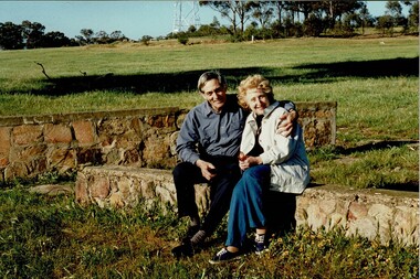
John and Val revisiting the site where they were internees in Camp 3 A during WW2.Colour photograph of a John and Val Fortuna sitting on the remains of a structure at Camp 3 in 1995internment camp 3, italian internees camp 3, john fortuna, val fortuna -
 Tatura Irrigation & Wartime Camps Museum
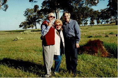
Photograph, Con Mafalda, John and Val Fortuna Camp 3A December 1995
John and Val revisiting the site where they were internees in Camp 3 A during WW2.Colour photograph of a Con Mafalda, John and Val Fortuna sitting on the remains of a structure at Camp 3 in 1995.internment camp 3, italian internees camp 3, john fortuna, val fortuna -
 Darebin Parklands Association
Rockbeare Park 1970s, 1973-1980
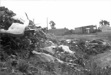
This photograph shows an area of the Darebin Parklands that was a tip site before it became part of the park.B&W photograph. Rubbish at the tip. -
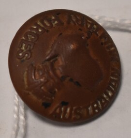 Tatura Irrigation & Wartime Camps Museum
Button - brass, P J King Pty Ltd, 1940's
Found at POW camp 13 site post war by war time camp guardBrass button with Australian Military Forces around front edge, map of Australia in centre with a crown above. Has a brass loop on the back to attach to clothing. Contained in a black material covered display case with gold around edge.on front: Australian Military Forces and a map of Australia and crown. on back P J King Pty Ltd Melbbrass buttons, camp 13, military uniform accessories -
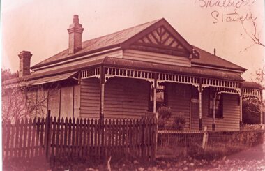 Stawell Historical Society Inc
Photograph, "Braeside" Heal Family home in Moonlight Street site now No 45
Home of Heal Family in Moonlight Street site now No 45. Home named Braeside. stawell -
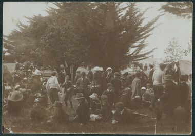 Uniting Church Archives - Synod of Victoria
Photograph, undated c.1912 - 1920
The Malvern Congregational Church was built in 1886 and demolished in 1996. A Coles Supermarket was built on the site.Sepia photograph of the Malvern Congregational Church Sunday School Picnic.Sunday School Picnicmalvern congregational church, sunday school, picnic -
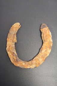 Glen Eira City Council History and Heritage Collection
Horseshoe
The horseshoe was found during excavating the site for the development of GESAC, East Boundary Road, Bentleigh. Iron horseshoe, U-shaped, dark and corroded with concretion / accretion of rusty coloured debris over much of the surface.No legible inscriptions. -
Federation University Historical Collection
Book, Tourism at the University of Ballarat - 1996 AH&TE Conference: Historic Mining Site Management, 1996
Tourism at the University of Ballarat - 1996 AH&TE Conference: Historic Mining Site ManagementWhite soft covered folder. mary hollick, public land in victoria, heritage legislation commonwealth, management issues, list of key mining heritage trails, preliminary market research, survey locations, university of ballarat, school of business, historic mining site, historic mining site management, tourism, mining heritage trails -
 Kyneton RSL Sub Branch
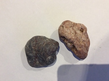
Gallipoli pebbles
The stones are a momento from Anzac Cove, the site of the Australian Infantry Force's landing in 1915.Landing at ANZAC Cove , 25 April 1915 Description As part of the attempt to seize the Gallipoli Peninsula in order to suppress the Turkish defences guarding the Dardanelles, military landings were made at Cape Helles at the southern tip of the peninsula (the main landing) and on the west coast near Ari Burnu. At this secondary objective two Divisions of the Australian and New Zealand Army Corps (ANZAC) landed in the darkness and faced rugged and difficult country. Units mixed up on their arrival rushed inland and became separated from the main force, which came under growing fire from the Turkish defenders. While Turkish reinforcements arrived, the ANZAC position became increasingly precarious as the assaulting force failed to secure their initial objectives. Falling back on improvised and shallow entrenchments the ANZACs held on for a crucial first night. By that first evening 16,000 men had been landed; of those over 2,000 Australians had been killed or wounded. www.awm.gov.au ANZAC Cove landingTwo smooth stones. Both would fit into the palm of a medium sized hand. One is dark, almost black, the other lighter, with a pinkish tinge.Catalogued as 108A and 108 Banzac cove, gallipoli -
 Eltham District Historical Society Inc
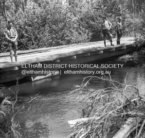
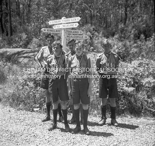
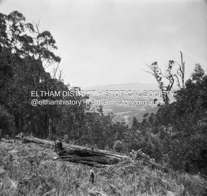
Photograph - Negative, Lewis Tulk, Scouting activities near Kinglake, Vic, c.May 1957
The Scouts used to set up camp at an old timber site near Tommys HutPrint copy stamped "17" on reverselewis tulk collection, kinglake, scout leader training, scouts victoria, tommys hut, timber mill -
 Eltham District Historical Society Inc
Photograph - Negative, Lewis Tulk, Scouting activities near Kinglake, Vic, c.May 1957
The Scouts used to set up camp at an old timber site near Tommys HutPrint copy stamped "17" on reverselewis tulk collection, kinglake, scout leader training, scouts victoria, tommys hut, timber mill -
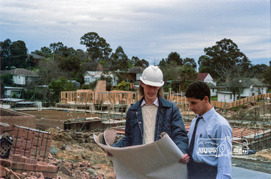 Eltham District Historical Society Inc
Photograph, Building site inspections, Shire of Eltham, c.1989, 1989c
Building inspectors (Danny Hick on left) from the Shire of Eltham review plans on site.Roll of 35mm colour negative film, 6 stripsFuji 100council staff, eltham shire council, shire of eltham, building construction, building inspector, danny hick, infrastructure -
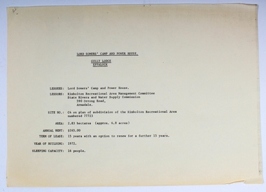 Melbourne Legacy
Plan - Document, plans, Lord Somers' Camp and Power House. Gully Lodge, Eppalock
Plans for the permanent camp site used by Melbourne Legacy in the second half of the 20th century.Most of the Junior Legatees would have stayed at Lord Somers' camp, which is still in use.6 photocopied plans and 1 cover sheet - A4 size - black on white, single sided.camp, lord somers camp, power house, eppalock -
 Ballarat Heritage Services
Photograph, Clare Gervasoni, 105 Lyons Street South, Ballarat Central from Dana Street, 05/2023
This photograph was taken while painters were on-site, the colour changing from green to grey. 105 Lyons Street South, Ballarat Central is a double brick Spanish Mission house with slate roof.105 lyons st south ballarat central, spanish mission, architecture, slate roof -
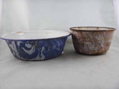 Parks Victoria - Days Mill and Farm
Domestic object - Bowls
Found in the above ground rubbish pile at Days Mill and Farm. Probably used on site.Two enamel bowls with marbleized patterning on the outside. The larger wider bowl is blue and white the smaller but taller bowl is pinky/beige and white. Both have white interiors. Both are rustedwilliam day, ann day, joseph day, robert day -
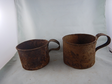 Parks Victoria - Days Mill and Farm
Domestic object - Mugs
Found in an above ground rubbish pile at Days Mill and farm. Probably used on site.Two rusted straight sided tin mugs with largish handles. One is smaller than the other.nowilliam day, ann day, joseph day, robert day -
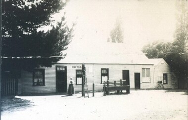 City of Ballarat Libraries
Photograph - Card Box Photographs, White Swan Hotel, Ballarat circa 1870
The site is now the White Swan Reservoir. The person pictured could be the licensee, Mrs Ritchie. white swan hotel, white swan reservoir, building, commerical, hotel, person -
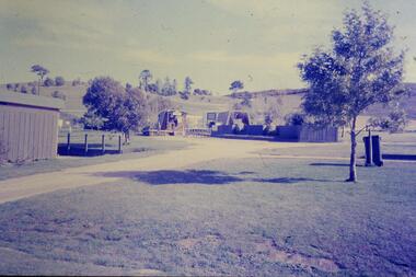 Greensborough Historical Society
Slide - Photograph, John Ramsdale, Park and kiosk, Whittlesea: Slide 63, 1990s
Photograph shows farm park and kiosk on Plenty Road Whittlesea. This is the future site of Funfields.Part of the John Ramsdale collection of slides and audio visual material.Colour photograph scanned from slide.No maker's marks. No caption on slide.funfields, plenty road whittlesea -
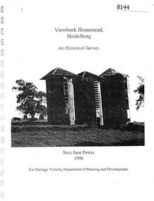 Greensborough Historical Society
Booklet, Sera Jane Peters, Viewbank Homestead, Heidelberg: an historical survey, by Sera Jane Peters for Heritage Victoria, Department of Planning and Development, 1996
History of the Viewbank Homestead, originally a 90 acre site with homestead and outbuildings, now demolished.Black and white photocopy of typescript, with photographs, plans, reproductions of documents. 25 p plus 17 p of Appendices, unboundviewbank homestead, heritage victoria -
 Buninyong & District Historical Society
Photograph - B/W photograph, Buninyong Masonic Lodge, 1993
The Buninyong Masonic Lodge was originaly formed in 1858. This brick building is the second hall on the site.Third oldest Masonic Lodge in Ballarat area, example of C20th public building.Black and White photograph of the Buninyong Masonic Lodge, double-fronted brick building, decorative concrete low-relief pillars, door and windows blocked. Also showing nature strip and roadway in Warrenheip Streetbuninyong, warrenheip st., masons., hall, building, streetscape