Showing 23838 items
matching boggy-creek-nowa-nowa
-
 Brimbank City Council Art Collection
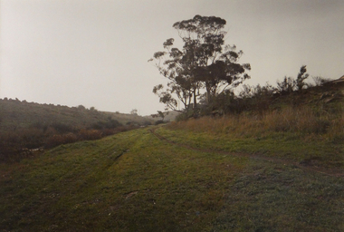
Photograph, Robert Pointon, East bank of the Kororoit Creed looking North, Deer Park, 1988
Local SceneDeer Park looking North up the river - Kororoit Creek - AR0021 -
 Stawell Historical Society Inc
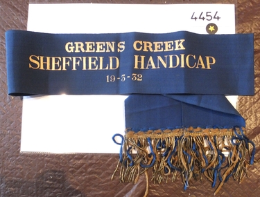
Memorabilia - Realia, 1932
Greens Creek Sheffield Handicap, Winners Sash 19-3-1932 stawell, sport -
 Stawell Historical Society Inc
Memorabilia - Realia, c1920's
Switchboard type phone from Pleasant Creek Hospital Training Centrestawell -
 Falls Creek Historical Society
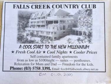
Article - Region Boasts Premier Skifields, 01/01/20000
A newspaper article from the Border Morning Mail on 01/01/2000. It describes developments on Victoria's skifields including Falls Creek, Mount Hotham and Mount Bogong.A newspaper article and advertisement for Victoria's skifields and the Falls Creek Country ClubA newspaper article from the Border Morning Mail on 01/01/2000. It describes developments on Victoria's skifields including Falls Creek, Mount Hotham and Mount Bogong.victoria's skifields, falls creek 2000, falls creek country club -
 Falls Creek Historical Society
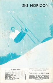
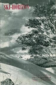
Journal - Ski-Horizon Vol 6 No 1, September 1954
Ski-Horizon is the official journal of the Federation of Victorian Ski Clubs which began publication in 1949. The were 26 original member clubs which included Albury Ski Club, Bogong Ski Club, Myrtleford Ski Club, Tallangatta and District Ski Club and Wangaratta Ski Club. Two pioneers of Falls Creek, Tom Mitchell, M.L.A., and Martin Romuld were Vice-Presidents of the Federation.This Journal is significant because it documents the early development of skiing in Victoria.The journal features stories and events chronicling developments in Victoria and internationally. Items related to the Falls Creek Area in this issue include:- Cover - Rudi Wurth, winner of the National Slalom and Downhill titles at Kosciusko, 1954. Page 2 - Rover Scouts help injured skier on Bogong High Plains Page 3 - Cecil Dobson is a real asset to the village. Apart from provisions he also provides services including ski repairs, carpentering and plumbing. Page 5 - "Wongapussie" - a word for an overboot. Originally found in disposal stores as they were used for anti-gas purposes, but something similar is now being made in Albury and being used extensively at Falls Creek.rudi wurth, cecil dobson, rover scouts rescue, "wongapussie" -
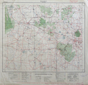 Federation University Historical Collection
Map, Ballarat, Victoria, 1942
Two copies of a map of the district around Ballarat, including Creswick, Scarsdale, Smythesdale, Lake Bolac, Ararat, Talbot, Sebastopol, Maryborough, Cardigan, Skipton, Mount Emu Creek, Leigh River, Fiery Creek, Hopkins River. Street names are listed on the back of the map. It includes roads, timber, creeks, rivers, telephone lines, railwayPrinted in red at the base of the map "This map is an official document. If found, itmust be handed in to the nearest Military Headquarters or Police Station.ballarat, map, world war two, skipton, creswick, ararat, lake bolac -
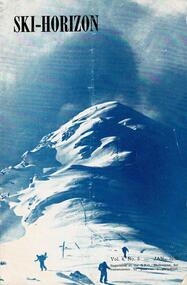 Falls Creek Historical Society
Journal - Ski-Horizon Vol 4 No 5, January 1953
Ski-Horizon is the official journal of the Federation of Victorian Ski Clubs which began publication in 1949. The were 26 original member clubs which included Albury Ski Club, Bogong Ski Club, Myrtleford Ski Club, Tallangatta and District Ski Club and Wangaratta Ski Club. Two pioneers of Falls Creek, Tom Mitchell, M.L.A., and Martin Romuld were Vice-Presidents of the Federation.This Journal is significant because it documents the early development of skiing in Victoria.The journal features stories and events chronicling developments in Victoria and internationally. There were no items directly related to the Falls Creek Area in this issue, but the inside back cover also included an advertisement for Fred Griffith's Romney Stud at Toonallock which was the regular venue for the Albury Ski Club Annual Ball.tom mitchell m.l.a., toonallook, fred griffith -
Bendigo Historical Society Inc.
Map - KNOWSLEY : COUNTY OF BENDIGO, 7-11-1941
Map. Knowsley, County of Bendigo, County of Rodney, Weston, Axedale, Eppalock, Knowsley East, Langwornor, Heathcote, Campaspe River, Mt. Ida Creek or Wild Duck Creek, Sandhurst and Heathcote Railway, Kilmore-Heathcote-Bendigo Road. Knowsley Station Ground. Shingle Hut Creek, Forest Creek. By authority H.E. Daw, Government Printer, Melbourne. Drawn and reproduced at the Department of Lands and Survey, Melbourne. 7-11-1941. Price 2/-. (number 103 in map cupboard 1)H.E. Daw, Government Printer, Melbourne.map, bendigo, knowsley -
 Southern Sherbrooke Historical Society Inc.
Photograph - Photos of three watercolour paintings by Les Cope
Photos of watercolour paintings of Menzies Creek by Les Cope. - based on a photograph of Menzies Creek in the early 20th Century. It shows Kings' store, the railway station, and the stationmaster's house, as seen from Menzies Rd. - image of the Menzies Creek store around the 1950s. It shows a man and woman talking on a bench, a red postbox, a telephone box, and a streetlight. - based on a photo of Menzies Creek, c.1900. It shows Kings Store and Post Office, with a postman on horseback and a group of adults and children in front of store. -
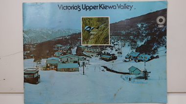 Kiewa Valley Historical Society
Booklet - SEC x2, 1. Victoria's Kiewa Valley 2. Victoria's Upper Kiewa Valley, No. 2 is dated October 1978
The State Electricity Commission of Victoria built the Kiewa Hydro Electric Scheme and was keen to promote tourism in the area. The booklet includes Facilities, Falls Creek Ski Resort, the Kiewa Works Area, the Three Floras of Bogong, the Geology of the Kiewa area, the Bird and Animal life of Bogong and the Kiewa Hydro Electric Scheme. The colored photos and the map on the back appeal to the reader/tourist.The SECV promoted tourism in the Kiewa Valley especially the area of the Kiewa Hydro Electric Scheme. This booklet is attractive and informative with a lot of detail. This proved to be the early stages of tourism in the area in what is now a very popular tourist destination and the main industry for the Upper Kiewa Valley.Blue cover with photo of Falls Creek at night. Title in black print at the centre top under which is an insert photo of a blue wren and SEC logo in white towards the top far right. Back cover is light green with a tourist map of the area. The text is complimented with brightly colored photos throughout.state electricity commission of victoria; kiewa hydro electric scheme; tourism; bogong; flora; fauna; geology; -
 Bendigo Military Museum
Book - BOOK DEMOBILIZATION, Demobilization procedure, Issued 9 Oct 1945
C.W Curnow. Refer Cat No 1444, 1445.2, 1446.2.Demobilization procedure book, AAB87, No 373082 re C.W Curnow."VX100151, L/Cpl Curnow, Clarence Wilfred, Campbells Creek Vic"documents, demobilization, curnow -
 Greensborough Historical Society
Aerial Photograph, Flintoff land - View from above, 1945_
Section of the 1945 Greensborough aerial survey, focusing on the land belonging to the Flintoff familyPhotocopy of section of 1945 aerial survey of Greensborough area"Flintoff land to west of Diamond Creek Rd" written in pencil on backflintoff family, aerial photograph -
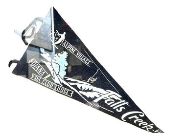 Falls Creek Historical Society
Memorabilia - Diana Ski Lodge Banner, 1960s
Diana Lodge was built and operated by Kevin Shoebridge as a family lodge in the 1950s and it has grown and evolved over 60 years to become Diana Alpine Lodge. After Mr. Shoebridge moved to Wodonga he leased Diana Lodge to Bob Scott and it also became the Post Office and Telephone Exchange. From early early 1967 until about 1975, Diana Lodge was owned and operated by John and Gwyn van Burck. It was then purchased by a group of 12 families operating as Swan Hill Alpine Holdings. Diana Alpine Lodge has operated under several owners and was sold again as recently as 2023. This pennant was used in the early 1960s as a souvenir to promote Diana Lodge.This item is significant because it promotes Diana Lodge, a long standing accommodation venue at Falls Creek.A black and white triangular banner including an image of a skier and a second person on a chair lift.ALPINE VILLAGE DIANA SKI CLUB LODGE FALLS CREEK, VICdiana alpine lodge, falls creek accommodation -
Whitehorse Historical Society Inc.
Document, Eastern Freeway Extension, 2000 - 2002
Eastern Freeway ExtensionEastern Freeway Extension- Cost estimates for community consultation option Public consultation process : report on analysis submissions Deep Creek Road - Landscape concept Media Release from Premier of Victoria VicRoads - Works update newsletters Whitehorse City Council minutes VicRoads Correspondence Schwerkolt Cottage Precinct - Concept Plan VicRoads maps.Eastern Freeway Extensioneastern freeway extension, vicroads, victoria. department of infrastructure, city of whitehorse, schwerkolt cottage, landscape planning, maps -
 Bendigo Historical Society Inc.
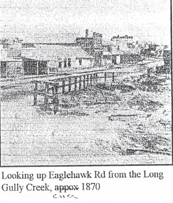
Photograph - LONG GULLY HISTORY GROUP COLLECTION: EAGLEHAWK ROAD FROM THE LONG GULLY CREEK
Photocopy of a photo with printing at the bottom: Looking up Eaglehawk Rd from the Long Gully Creek, circa 1870. The photo has buildings along the left of the road and in the foreground is a timber railing at the edge of a creek.bendigo, history, long gully history group, the long gully history group - eaglehawk road from the long gully creek circa 1870 -
 Bendigo Historical Society Inc.
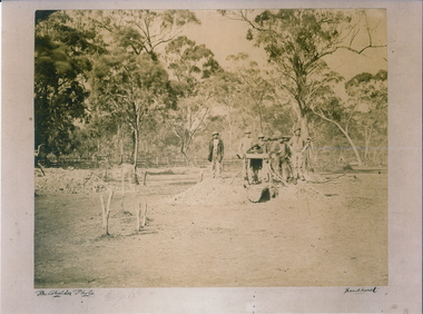
Photograph - MYERS CREEK DIGGINGS, c1867
Sepia Photograph: Myer's Creek Diggings 'Bachelder Photo Sandhurst'. 6 male 'Diggers' gathered around a windlass at a mine opening amongst the trees in a paddock. Inscription Markings: Myers Creek Diggings 1867place, mining site, myer's creek diggings -
Lakes Entrance Regional Historical Society (operating as Lakes Entrance History Centre & Museum)
Book, Fairweather, Keith Mc D, Brajerack - Mining at Omeo and Glen Wills
A Description of the mining industry in the northern part of of the Shire of Omeo, Victoria,dealing with the settlements of Omeo, Glen Wills, Sunnyside, Saltpetre Creek and Wombat, also Cobungra River and Newrush Creek. Aboriginal identities IllustratedRuth Clarkaboriginals, mines and mining, land settlement -
 Falls Creek Historical Society
Journal - Ski-Horizon Vol. 2 No 10, June 1951
Ski-Horizon is the official journal of the Federation of Victorian Ski Clubs which began publication in 1949. The original member clubs were Albury Ski Club, Alpine Club of Victoria, Australian Postal Institute Ski Club, Australian Women's Ski Club (Victoria), Beechworth Ski Club, Bogong Ski Club, Bull Lodge Ski Club, Chamois Ski Club, C.S.I.R. Ski Club, Edelweiss Ski Club, Howqua Ski Club, Lazy Eight Ski Club, Melbourne University Ski Club, Melbourne Walking Club, Monsanto Ski Club, Moose Ski Club, Myrtleford Ski Club, Rongbuk Ski Club, Tallangatta and District Ski Club, Tanjil Ski Club, Telemark Ski Club, University Ski Club, Victorian Rover Scouts (B.S.A.), Wangaratta Ski Club, Youth Hostel Association, Yurredla Ski Club. Two pioneers of Falls Creek, Tom Mitchell, M.L.A., and Martin Romuld were Vice-Presidents of the Federation. The journal features stories and events chronicling developments in Victoria and internationally.Ski-Horizon is the official journal of the Federation of Victorian Ski Clubs which began publication in 1949. The were 26 original member clubs which included Albury Ski Club, Bogong Ski Club, Myrtleford Ski Club, Tallangatta and District Ski Club and Wangaratta Ski Club. Two pioneers of Falls Creek, Tom Mitchell, M.L.A., and Martin Romuld were Vice-Presidents of the Federation.This Journal is significant because it documents the early development of skiing in Victoria.The journal features stories and events chronicling developments in Victoria and internationally. Items related to the Falls Creek Area in this publication include:- Page 2: Albury Ski Club is set for a positive year. Present membership of the club is 130 and officials. recently elected are: -President, Mr. Fred Griffith; Vice-President and Booking Officer, Bob Howe; Secretary. Nell Newton; Asst. Sec., Angela Bowler; Treasurer. Sam Roxburgh; Social, Bruce Colquhoun: Trips, June Watson; Bus, Len Egan; Building. John Perger; Equipment, Peter Hadow. Page 3 Toni St. Elmo is planning the monster party the Bogong Ski Club will give at their Falls Creek Lodge on 4th August to the visiting N.Z. team. Page 8 - 9 Article - The Old Order Passes on the Bogong High Plains - an extensive response to the State Development Committee's Report "The Alpine Regions of Victoria; Skiing and Tourist Resorts" and suggestions for the construction of roads, ski tows and other facilities. A sketch map of Falls Creek Village is included.ski history victoria, federation of victorian ski clubs, development of falls creek -
 Bendigo Historical Society Inc.
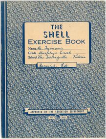
Document - M. Symons' Murpheys Creek Exercise Book
Land was first selected at Murphy's Flat in 1865. The first Wesleyan church was built in 1866 and from 1869 this was used as State School 149. A purpose built school, No. 1311 opened mid 1876. The areas name was changed to Murphy's Creek in 1915.A blue and white exercise book. Attached within are various subscription receipts in the front and back, including the "Australian Home Journal," "Singer Sewing Machine Company," and an "Annual Audit of Depositors' Pass-books by the State Savings Bank of Australia. Also included in approximately half the book are handwritten record of correspondence notes in blue ink, many regarding sewing from 1949-1956.The Shell Exercise Book. Name: M. Symons (Handwritten Blue Ink). Grade: Murphys Creek. School: Via, Tarnagulla, Victoria (Handwritten Blue Ink). Receipts, Etc.(Handwritten Blue Ink), Approved by the Education Department. Shell Series. On the back is printed Arithmetic Tables and a Multiplication Tableexercise book, receipts, tarnagulla -
 Falls Creek Historical Society
Photograph - Fitgerald's Hut to Shannonvale, 1937
MEYER COLLECTION - FALLS CREEK PHOTOS In 1947 a determined group of like-minded State Electricity Commission (SEC) staff including Ray Meyer, the chief surveyor of the Kiewa Hydro-Electric Scheme, had a common interest that revolved around the skiing potential of the snow-covered high plains which included what is now the resort of Falls Creek. The six SEC employees, Toni St Elmo, Ray Meyer, Jack Minogue, Lloyd Dunn, Adrian Ruffenacht and Dave Gibson (together with their families) banded together to secretly build a 'hut' that was the first ski lodge at Falls Creek. Using a road built in 1930s to gain access to Falls Creek, their hut project was carried out in secret as efforts by other skiers were blocked by H.H.C. Williams – the engineer in charge of the Hydro Scheme. In 1946 Ray Meyer made a trip to the Lands Office in Melbourne. He came away with a 99-year lease on three acres that was ideally suited for a hut designed by Lloyd Dunn. Adrian Ruffenacht (Design Engineer for the KHS) had suggested where the group should build because of easy access to a spring for water. Much of the building material required was scavenged from derelict huts on the high plains. Due to the need for secrecy, the determined group worked on the hut in the evenings and weekends to avoid detection. During the building period the group had met at Echidna Rock (now known as Eagle Rock) where Skippy St Elmo announced, "This is my favourite ‘Skyline’.” And so the first lodge in the area at Falls Creek Ski Resort came into existence. With the development of the International Poma in the 1970s, the Skyline Lodge, which was sited between the ski-lift’s pole one and pole two, was demolished. However, the legacy of Ray Meyer, Toni St Elmo, Jack Minogue, Lloyd Dunn, Adrian Ruffenacht and Dave Gibson and Skyline lives on in the vibrant atmosphere of Falls Creek Resort. The MEYER COLLECTION documents developments on the Kiewa Hydro Scheme and their life at Falls Creek from the mid 1930s to 1960s.These images are significant because they depict aspects of the life of a pioneering family of Falls Creek and the founders of "Skyline", the first lodge at Falls Creek.A collection of photos related to a sledge trip between Fitzgeralds Hut and Shannonvale in September 1937. 1. L - R:- Cyril Louder, Eileen McEvoy, Bill Burrows (?), Dad Fitzgerald, Olive Sandell (standing in front of Marie Hatters) 2. Little Jimmy Wheeler 3. Fitz's Hut - leaving for Shannonvale 4. Looking down Middle Creek valley from SEC Camp Bogong High Plains 5. Tom Fitzgerald has a nap at Fitz's Hutfalls creek, fitzgerald hut, shannonvale, sledge party 1937 -
Tarnagulla History Archive
Telegram, circa 1862
A large lot of papers, including this and other telegrams, were apparently found in the ceiling cavity of the Sandy Creek/Tarnagulla Post and Telegraph Office in the later 20th Century, during building works. Donald Clark Collection. Telegram sent from Sandy Creek / Tarnagulla Telegraph Office. From John Papineau (on behalf of E.N. Francis) to Mrs Giradini, Sandhurst. Text reads 'Your brother and his mate bought a horse at Cochrane's Diggings which had been stolen and the police found it in their possession. They are innocent but I have to bring witnesses a long distance. I shall defend them in expectation of securing the five pounds from you'. -
Bendigo Historical Society Inc.
Photograph - POSTCARD - ANTICLINE ON BENDIGO CREEK
Postcard: anticline on Bendigo Creek. Sepia print on postcard. Anticline in centre of photo. Paling fence extends along entire back of photo. Behind fence small weatherboard building ( outhouse ? )Written on back in pencil ' anticline in creek at Golden Square, area of old bridge over Bgo creek' Stamped in blue ' Bendigo Institute of Technology, Geology Dept. 'place, gold, bendigo creek, bendigo, gold, anticline, bendigo creek, discovery of gold in bendigo -
Bendigo Historical Society Inc.
Map - CAMPBELL COLLECTION: BENDIGO AND DISTRICT MAPS
Map. Lockwood, Parishes of Lockwood and Shelbourne, scale 20 chains to 1 inch. Spring Creek centre of map and Bullock Creek to the right. Total area 4405 acres. (number 358 in map cupboard 1)map, bendigo, allotments -
Bendigo Historical Society Inc.
Drawing - HARRIS COLLECTION: CHARCOAL SKETCH OF CREEK AND HUT
Charcoal sketch on cream background of creek, small hut on bank, eucalypts on LH side and in background. Most probably a depiction of the Harris orchard/vineyard on Axe Creek, Axedale, near the bridge on the Mt. Sugarloaf Road.George Harris, Axedaleartwork -
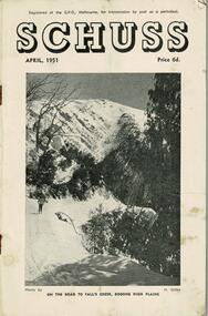 Falls Creek Historical Society
Journal - Schuss Vol. 17. No. 4 April 1951
Schuss was advertised as Victoria’s Official Ski Journal It was issued monthly from 1935 to 1961 except during the war when summer issues covered two months. This continued after the war, but it averaged 10 issues annually over its 25 year life. Schuss was published by the Ski Club of Victoria which had a membership of 38 Ski Clubs and demanded to be recognised as the prime authority on skiing in the state. The other 30 ski clubs with 85% of the members disagreed and the politics of skiing became heated. These clubs formed the Federation of Victorian Ski Clubs with their own journal, Ski Horizon. With the establishment of the Victorian Ski Association, Ski-Horizon published its last issue in Nov - Dec. 1955 and the role of the official journal was fully taken over by “Schuss”. This item is significant because it contains stories, images and information documenting the development of the ski industry in Victoria.The journal features stories and events chronicling developments in Victoria and internationally. Items related to the Falls Creek Area in this issue include:- Cover - Features a photo by H.Gibbs titled "On the road to Falls Creek, Bogong High Plains"schuss journal, the ski club of victoria -
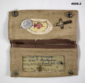 Bendigo Military Museum
Accessory - IDENTIFICATION, CATHOLIC, C.1940 - 45
H.V.Rooke. Refer Cat No 4906.2 for service details..1) Cloth folding wallet light brown colours, inside has small crucifix, badge and oval created edge piece sewn in, has central flower with black writing, other half has open piece with clear plastic sleeve for ID card. .2)Catholic Identification card black print 4 pages, front has space for owners details, written in blue ink..1) “Thy Kingdom Come”. .2) hand written, “VX47141 Pte H.V. Rooke 2/29th Battalion 31 creek St Bendigo, wife 31 Creek St Bendigo”accessory, id, identification, catholic -
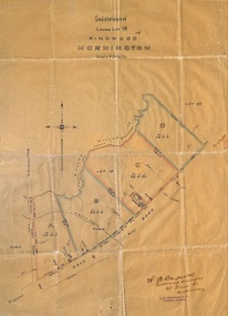 Ringwood and District Historical Society
Plan, Subdivision of Crown Lot 19, Ringwood, Victoria - circa 1915
Surveyor's map on wax paperSubdivision map includes Mullum Creek, Government Road to Anderson's Creek, later Warrandyte Road, Government Road to Lillydale, later Whitehorse Road, small creek bridge, later Sandy Creek at Ringwood Lake. Buildings marked include Roman Catholic Church, O.J. Pratt's House and Pratt's butcher shop (photos attached). Map by A.B. Bruford & Co., Licensed Surveyor, 47 Queen Street, Melbourne. -
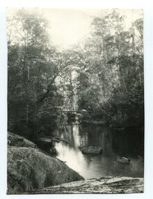 Orbost & District Historical Society
black and white photograph
A black / white photograph of a bush scene with a creek and what might be a bridge in background.creek river bush-scene -
Glenelg Shire Council Cultural Collection
Negative, c. 1936
Transparency for black and white photo. Portland Botanic Gardens, Salt Creek in foreground -
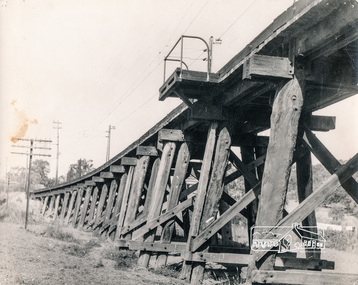 Eltham District Historical Society Inc
Photograph, George W. Bell, Trestle Bridge, Eltham, 1960c
Black and white photograph of Railway Bridge over Diamond Creek c.1960railways, bridges, eltham, diamond creek, george w bell collection