Showing 25660 items
matching plenty-township-estate
-
 Whitehorse Historical Society Inc.
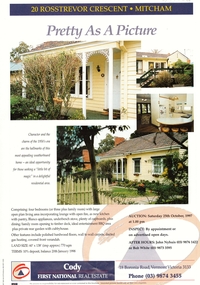
Document, 20 Rosstrevor Crescent, 1/10/1997 12:00:00 AM
Estate agent's advertisement for No 20 Rosstrevor Crescent, Mitchamrosstrevor crescent, mitcham, no 20 -
 Whitehorse Historical Society Inc.
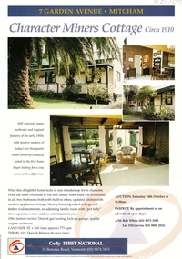
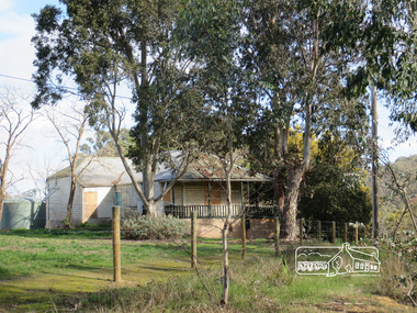
Document, Miners Cottage, 1/10/1997 12:00:00 AM
Estate agent's advertisement fEstate agent's advertisement for No 7 Garden Avenue, MitchamEstate agent's advertisement fgarden avenue, mitcham, no 7 -
 Robin Boyd Foundation
Slide, Robin Boyd, 1969
Robin Boyd travelled to the USA and Britain for several weeks. He attended the opening of the new Australian Chancery in Washington DC, where he had designed an innovative exhibition with cylindrical display cases and sound recordings.Colour slide in a mount. Thamesmead Estate, London, EnglandMade in Australia / 1 / JUN 69M2slide, robin boyd -
 Bendigo Historical Society Inc.
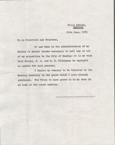
Document - EDWIN BUCKLAND COLLECTION: EXECUTORS AND TRUSTEES, 29/06/1951
Document. Letter of instructions to the Executors and Trustees of my Estate. -
 Stawell Historical Society Inc
Memorabilia - Realia
Health Care Wallet from Estate of Jill Gammonstawell, medical -
 Port Fairy Historical Society Museum and Archives
Photograph, Jock Varcoe
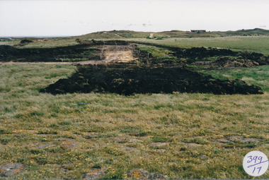
South Beach DevelopmentColoured photograph of Road building on South Beach Estatesouth beach, development, road, street, building -
 Melton City Libraries
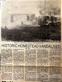
Newspaper, Historic Homestead Vandalised, 1990
Edna Barrie describes the Darlingsford property. C.E. Barrrie Land developers bought the property from my husband’s brother. It was one big farm and they were a big family. When the father died he left it to be cut up for the family. The youngest son had to reach age 21 before the property could be divided and portioned out to the mother and children, but it was deferred until Jim returned from the war. Eventually it was cut up into two parts, we were married by then and so was Edgar. Part of the land included the block on the other side of Ferris road, which became the quarry, Edgar’s section was on the Toolern Creek end, he was the last one married and lived in the old bluestone house until 1974. The developers bought this section but they could not get permits due to the state of the old bridge due to the cost. Barries had built the bridge across the creek [1926]. It took the big loads of hay and the family kept it maintained. Once the Barries had gone it did not get any upkeep. The developers found the cost of replacing the bridge and developing site with sewerage and drainage power before they sell. The rural land itself is not worth much as the developer has to complete the subdivision before any blocks can be sold. The developer from Sydney had a man living in the house, who let it go the rack and ruin. He managed to buy from the developer 25 acres with the bluestone house. Bernard Coburn had it for a while but is was well out of our hands by then. There were various people who have bought into and tried to develop and have given up. There was a project sometime ago to save the buildings from ruin but nothing has happened as yet, they are six or seven years to late. The buildings continue to deteriorate and were badly damaged vandals and fire. The Shire bought all the rest of it from the developer, where the tip is now, that was also part of Edgars land. Article about a fire at Darlingsford Estate featured in the Telegraphlocal architecture, local identities, emergency services -
 Melton City Libraries
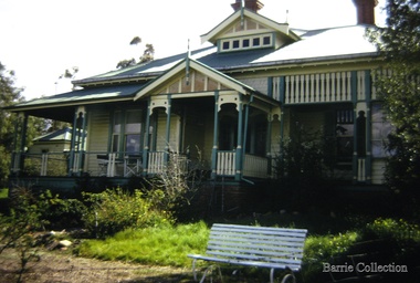
Photograph, "Green Hills" Borbidge, 1978
Built by Water Browne c.1903 Greenhills was one of the first pastoral runs, and centres of European settlement, established in the Shire of Melton. Estate in Diggers Rest Coimadai Road, Toolern Valelocal architecture, pioneer families -
Bendigo Historical Society Inc.
Map - CAMPBELL COLLECTION: BENDIGO AND DISTRICT MAPS, 21-8-1972
Map. Shire of Strathfieldsaye, Locality Plan. Scale I inch=1 mile. Shire of Huntly, Shire of McIvor, City of Bendigo, Shire of Marong, Shire of Maldon, Shire of Metcalfe. Lake Eppalock. Mileage markers on some roads. Melbourne to Bendigo Railway Line, Big Hill Tunnel, Mt.Herbert 1596.Axedale Township, Strathfieldsaye Township.M.Higgs 21-8-1972map, bendigo, locality plan -
Bendigo Historical Society Inc.
Map - CAMPBELL COLLECTION: BENDIGO AND DISTRICT MAPS, 1962
Map. Mandurang, County of Bendigo. Scale 40 chains to 1 inch. Sandhurst, Strathfieldsaye, Sedgwick, Sutton Grange, Ravenswood, Lockwood, Township of Kangaroo Flat, Township of Mandurang. By Authority A.C. Brooks, Government Printer, Melbourne. Drawn and Reproduced at the Department of Lands and Survey, Melbourne,1962, Price 2/-. (number 401 in map cupboard 1)A.C. Brooks, Government Printer.map, bendigo, allotments -
 Bendigo Historical Society Inc.
Photograph - HARRY BIGGS COLLECTION: LONG GULLY TOWNSHIP
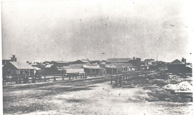
Photograph. Harry Biggs Collection. 1 black & white photo of Long Gully township looking from Eaglehawk towards Bendigo near the bridge. On 1 shop can be seen P Pentreath. A wooden bridge can be seen over the creek. Long Gully Township looking from Eaglehawk to Bendigo near bridge (written on the back).photograph, streetscape, long gully, harry biggs collection, long gully township -
 Phillip Island and District Historical Society Inc.
Newspaper clippings
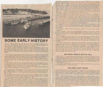
Album donated by Miss Edith Elms via Chrisy Northcote. Details from 1758 visit by Bass, Wattle Bark export in 1833, opening of surrounding district with pioneering families, Estate Agent, John Keam & Co and the installation of Postal services in 1873 (brief history of San Remo 1798 - 1928)Two clippings with sub-headings "some early history" - San Remo Heights Estate Hall and San Remo Post Office. Photo of San Remo Port with fishing, boat middle, at top of article large sub-heading "San Remo"Titled San Remolocal history, documents, newspapers, san remo, local area development by europeans, newspapers san remo -
 Orbost & District Historical Society
black and white photograph, 1960s - 1970s
This photograph shows the former Orbost Police Station in Wolseley Street before it was demolished and a new larger brick building was built behind it in Lawson Lane - late 1980s.This is a pictorial record of a significant community building no longer existing.A large black / white photograph of the Orbost township police station. It is a weatherboard building surrounded by trees. A sign "POLICE" is hanging from a pole.on back - " Orbost Police Station in Wolseley Street, Donated by Debbie Hall 31/8/94"orbost-police-station -
Clunes Museum
Document
.1 DAYLESFORD AND HEPBURN SPRINGS 14 PAGES, ACCOMMODATION, SITES, CHURCHES, MAPS .2 TALBOT TOWNSHIP, SHORT HISTORY AND POINTS OF INTERESTtalbot, daylesford hepburn springs, history maps points of interest -
Lakes Entrance Regional Historical Society (operating as Lakes Entrance History Centre & Museum)
Postcard, W S Vogt Bairnsdale, 1918 c
Black and white postcard showing township, roads and rail, bridges and barked trees with cultivated land beside Tambo River Bruthen VictoriaTambo River at Bruthenjetties, waterways, topography, boats and boating -
Clunes Museum
Map - MAPS
A MAP OF CLUNES TOWNSHIP. ORIGINAL AND COPY. ALL STREETS WITH ALLOTMENT NUMBERS CRESWICK CREEK - KILKENNY CREEK - BALLARAT TO MARYBOROUGH RAILWAY LINE.CLUNESlocal history, document, maps, clunes township -
 Clunes Museum
Photograph, 1911
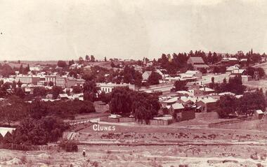
COPY OF POSTCARD OF TOWNSHIP OF CLUNES 1911, TAKEN FROM SCENIC DRIVE, SHOWING FRASER STRRET BUILDINGS, ST PAUL'S CHURCH ETC.CLUNESlocal history, document, postcard, clunes township -
Clunes Museum
Print - DISPLAY PANEL
COPIES OF DISPLAY PANELS DONATED TO THE PEOPLE OF CLUNES BY THE HUGH WILLIAMSON FOUNDATION.1 INTERPRETIVE DISPLAY PANEL DEPICTING THE DISCOVERY OF GOLD AND THE DEVELOPMENT OF THE TOWNSHIP OF CLUNES IN A WOODEN FRAME .2 LAMINATED COPY OF THE DISPLAY PANELlocal history, civic momentoes, presentations., williamson, hugh foundation -
 Clunes Museum
photograph
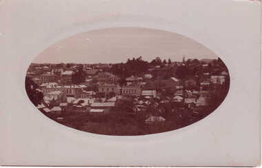
OVAL PHOTOGRAPH - POST CARD PHOTOGRAPH, OF CLUNES TOWNSHIP. .1 ORIGINAL POSTCARD, OVAL PHOTOGRAPH ON GRAY CARDBOARD .2.3 PHOTOCOPIES OF THE POSTARDlocal history, photography, photographs, clunes township -
 Lakes Entrance Regional Historical Society (operating as Lakes Entrance History Centre & Museum)
Postcard, 1945c
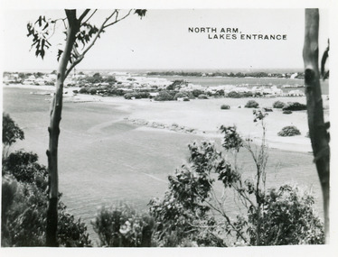
Photo taken soon after extensive dredging operations when tons of sand were dumped on low lying land at western end of town.Black and white small format postcard of the North Arm. It shows the township between North Arm and Cunninghame Arm. Lakes Entrance VictoriaNorth Arm Lakes Entrancewaterways, topography, fences -
 Lakes Entrance Regional Historical Society (operating as Lakes Entrance History Centre & Museum)
Postcard, 1930c
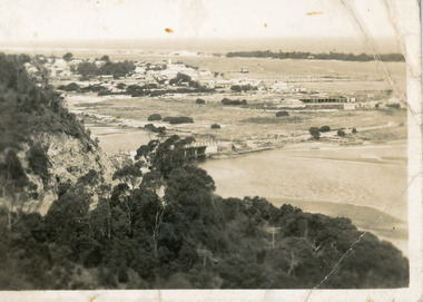
Black and white small format postcard showing the township situated on the land between the Cunninghame Arm and North Arm. Lakes Entrance VictoriaLakes Entrance from Princes Highway (on back)bridges, township, topography, waterways -
 Lakes Entrance Regional Historical Society (operating as Lakes Entrance History Centre & Museum)
Photograph, Fraser, Nancy, 1970c
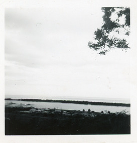
Black and white photograph of a distant view township and Cunninghame Arm and scrub covered hummocks of southern shore in distance. Lakes Entrance Victoriaislands, jetties, topography, waterways, roads and streets -
Lakes Entrance Regional Historical Society (operating as Lakes Entrance History Centre & Museum)
Photograph, F Cornell, 1870
Black and white photograph of the punt on the Mitchell River and the first bridge under construction. In distance can be seen the growing township of Bairnsdale Victoriaboats and boating, waterways, businesses -
Lakes Entrance Regional Historical Society (operating as Lakes Entrance History Centre & Museum)
Photograph, 1/04/1990 12:00:00 AM
There was a deluge overnight in headwaters of Mitchell and Avon Rivers so the rivers rose overnight and flooded low lying areasColour aerial photograph of Mitchell River in flood showing Clifton Waters Village in centre and township of Wy Yung near Bairnsdale Victoriawaterways -
Southern Sherbrooke Historical Society Inc.
Book - Local History, Longman Cheshire Pty Ltd, Story Of The Dandenongs, First published 1959, thisa copy reprinted 1982
pp.xv, 415, hardback, appendices, index of names. History of exploration & development,local government & services and the townships of the Dandenong Ranges, 1838-1958.dandenong ranges, local government, white settlement -
 Federation University Art Collection
Work on paper - Artwork - Printmaking, Jack, Kenneth, 'Long Gully near Bendigo' Kenneth Jack, 1960
Framed Limited Edition print showing a mining township at Long Gully, Bendigo. Donated through the Australian Gifts Programme by Katherine Littlewood.29/40goldfields, poppet head, bendigo, long gully, tram -
 Eltham District Historical Society Inc
Photograph, Shire of Nillumbik World War One Memorials tour, 10 August 2016, 10 August 2016
As part of a program to acknowledge the Anzac Centenary Nillumbik Shire Council partnered with Yarra Plenty Regional Library to provide a bus tour with commentary of local sites of significance. These included Eltham township, the Shire of Eltham War Memorial at Kangaroo Ground, Christmas Hills war memorial, Hurstbridge memorial recreation park and finshed at Eltham Library to view the Writing the War exhibtion at Eltham Library Community Gallery. House located near the Christmas Hill War MemorialBorn Digitalchristmas hills -
 Eltham District Historical Society Inc
Photograph, Shire of Nillumbik World War One Memorials tour, 10 August 2016, 10 August 2016
As part of a program to acknowledge the Anzac Centenary Nillumbik Shire Council partnered with Yarra Plenty Regional Library to provide a bus tour with commentary of local sites of significance. These included Eltham township, the Shire of Eltham War Memorial at Kangaroo Ground, Christmas Hills, Hurstbridge memorial recreation park and finshed at Eltham Library to view the Writing the War exhibtion at Eltham Library Community Gallery. Display - The Roads through Christmas Hills in the Christmas Hills Mechanics InstituteBorn Digitalchristmas hills mechanics institute, heritage display -
 Eltham District Historical Society Inc
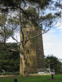
Photograph, Shire of Eltham War Memorial, 10 August 2016
As part of a program to acknowledge the Anzac Centenary Nillumbik Shire Council partnered with Yarra Plenty Regional Library to provide a bus tour with commentary of local sites of significance. These included Eltham township, the Shire of Eltham War Memorial at Kangaroo Ground, Christmas Hills, Hurstbridge memorial recreation park and finished at Eltham Library to view the "Writing the War" exhibition at Eltham Library Community Gallery. Shire of Eltham War memorial at Kangaroo Ground War Memorial ParkBorn Digitalworld war 1, war memorials, shire of nillumbik, kangaroo ground, shire of eltham war memorial, tower, fire spotting cabin, park -
 Ringwood and District Historical Society
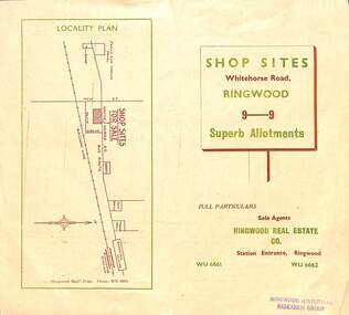
Flyer, Ringwood Mail, Retail Subdivision Brochure - Plan of New Shop Sites, Ringwood, Victoria. - circa 1950
Double sided folded page advertising shop sites in Whitehorse Road, Ringwood, with locality plan, price list, terms of sale, summary of local facilities and services, and diagram showing layout of 9 retail allotments for sale. These sites were originally zoned as residential as part of the 1926 "Olive Grove Estate" subdivision. (See Vicorian Collections Reference 5169). The 9 new shops were later allocated street numbers 58 to 64 Whitehorse Road, Ringwood.Locality plan showing shop sites for sale on Whitehorse Road, Ringwood, between New Street and Olive Grove. Sole Agents: Ringwood Real Estate Co., Station Entrance, Ringwood, (Telephone) WU6661, WU6662.